
The Voyages of s/v Silverheels III
...a virtual ship's logbook, and some thoughtful (unabashed?) reflections on our sea-going experiences.
04 November 2017 | Somewhere in the Eastern Caribbean
18 October 2017 | Le Marin, Martinique in the French West Indies
25 January 2017 | Gosier, Guadeloupe
19 January 2017 | Le Gosier, Guadeloupe
19 January 2017 | Le Gosier, Guadeloupe
19 January 2017 | St Pierre, Martinique
06 January 2017
01 January 2017 | Fort Du France, Martinique
28 December 2016 | Grand Anse d'Arlet, Martinique
24 December 2016
14 November 2016 | St Anne, Martinique
06 October 2016 | St Anne, Martinique
04 October 2016
20 July 2016 | Rodney Bay, St Lucia
15 June 2016
15 June 2016
13 June 2016
13 June 2016 | Grand Anse d'Arlets
13 June 2016 | Grand Anse d'Arlets
09 May 2016 | Deshaies, Guadeloupe
"Tough"-ton Falls?
25 August 2014 | St George, Grenada
Lynn
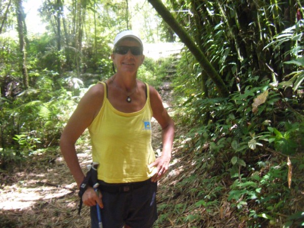
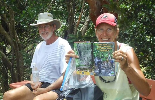
A friend of mine here in Grenada publishes a very good map of Grenada and her sister islands. It is a tourist map, and this one takes care to mention historical sites and some of the more interesting natural attractions. He has Tufton Falls on the map. He is also the publisher of "Discover Grenada", a useful tourist guide, and also mentions that hike in there. This is a hike that has intrigued me for a while.
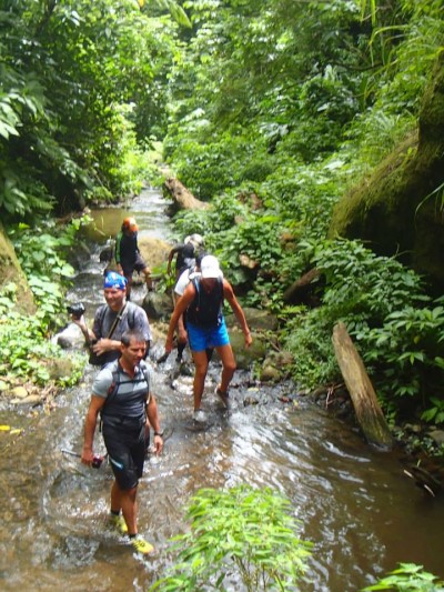
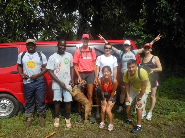
I finally did a shout out to the Grenada hashers to see if someone else was interested in doing this hike. It ends up there were 13 other people who were interested... but not everyone knew what they were getting into. Tufton Falls is arguably the toughest hike that one can do without wielding a machete and bushwhacking your own trail. No, you only have to climb up a river for about 3.5 hours.
Rolf, my publishing friend, was one of the hikers. He had never done the full hike, and since his birthday was the next day, the timing was ideal for him. We had a medical student, Mia, who decided that this would be a neat hike to do on her birthday and coerced three other friends to join her. A few more experienced hashers and cruisers rounded out the group.
The hike starts out going through some farmers' fields, and we saw nutmeg and cocoa, as well as staple foods like dasheen/callalloo and bananas. Eventually, the focus becomes more concentrated on the river. At this point, it turns into more of a spawn than a hike at times. Hikers pass through mini rapids and climb rocks down which water cascades merrily down and around. There is no way anyone could ever hope to stay dry on this hike.
At about 45 minutes in, we had the first casualty. One of the cruisers slipped and tried to catch his balance on a large rock. Unfortunately for him, the rock wasn't as solid as it looked to be, and he broke his wrist. I was going to walk back with him to the parking area, but one of the medical students said that she had enough and was willing to accompany our wounded companion back. Fortunately for him it was a very stable fracture, and they took their time getting back down.
We continued on. Sometimes we would find a trail that went off to the side and would help us avoid the more formidable climbs. In all of this, we were surrounded by cascades of water leaping off boulders and rock walls, with little calm areas giving way to more rushing water as it coursed through a narrowing in the stream bed. Footing varied from pebble bottom to slippery rocks, or possibly even a pool that was too deep to wade. We all took turns leading and looking for alternate routes around the larger obstacles.
There were some tricky areas, with poor footing or slick rocks, but we managed to get through it without further major injury. We did end up with only two of us not paying the "forest tax" in blood or bruises, and some paid more than others. Our friend Dalynn slid down off a path when her hand hold broke, basically beating up her left side. It was too late for any possible stitches for her elbow by the time we returned to civilization. The abrasion on her left leg was quite colourful.
We finally got up to what may be dubbed as either "WTF Rock" (everyone's initial reaction at seeing it) or "Chicken Rock", for the two of us who chose not to go up it. This is a rocky drop (or climb when going up) that someone has put a rope on. It goes behind a waterfall, and then one must use the rope and the slick looking rocks to climb up the rest of the way. This is the path to the Tufton Falls. This is when I said "no, not me". One other person had the same feeling, and the rest continued up. The pictures of the upper part are quite impressive, and I WILL get up there this year. I just thought of the accidents I have been around while hiking and having fun, and it just didn't seem worth it. If something had happened to me, Ken would have been very upset. (When he saw the pictures, Ken actually commented that he was relieved I didn't go up. He is not so happy about me saying I want to go back.)
When we regrouped (some looked more practiced than others at the rope thing), we had a bite of lunch and headed down. Going down had some advantages, as some of the chutes and up climbs were much easier to go down. There were a few natural slides into pools that a couple of us took advantage of. But we still had to slog down the river to get back. We found a few more trails that made it a touch easier to get down, but it still took about careful footing and work to climb back down the river.
We made it back to the last river crossing. We cleaned the river gravel out of our shoes and socks, and had a nice soak in the cool water, getting a little dirt off, checking for wounds, and relaxing. We then headed back the rest of the way to the cars and our bus... and our wounded who waited for us through it all.
We stopped for birthday rum for Mia and Rolf, and a shot and a beer for our injured. Well, they weren't the only ones to have a drink. And we stopped for (somewhat) frozen custard at Mom's rum shop on the drive back down from Victoria. We eventually managed to communicate with everyone "back home" to let them know we were alive, as we actually thought the hike would be about 4 hours round trip! Cell phone coverage was not an option on the river, or even where the cars were.
We ended up taking 7.5 hours to do it all (okay, I waited for about an hour of that for the others at Chicken Rock). We did not waste a lot of time, and moved pretty steadily. The hike is a workout, and all of us felt our muscles protest the next day, both upper and lower body. It is a hike that takes you through rapids and water chutes, through mud and bush, easily traversed fords and areas that challenge the most practiced trekkers. And I will do it again! Just next time, we may not do a return trip, but continue up and over Mt. St. Catherine, the highest peak in Grenada. I doubt it could be much harder.
Photo courtesy Dalynn Kearney
Comments
| Vessel Name: | Silverheels III |
| Vessel Make/Model: | Hinterhoeller, Niagara 35 Mk1 (1979) |
| Hailing Port: | Toronto |
| Crew: | Lynn Kaak and Ken Goodings |
| About: | After five summers and winters living on our boat in Toronto Harbour, we've exchanged those cold Canadian winters for Caribbean sunshine. "Nowadays, we have ice in our drinks, not under the boat." |
| Extra: |
Silverheels III's Photos - Silverheels III (Main)
Photos 1 to 14 of 14 |
1 |
 |
 |
 |
 |
 |
 |
 |
 |
 |
 |
 |
 |
 |
 |
1 |
 |
 |
The completely biased and unabashed musings from the crew of Silverheels III
Who: Lynn Kaak and Ken Goodings
Port: Toronto
SailBlogs Friends


