Slow Sailing
25 February 2020
29 November 2019 | Vero Beach
09 October 2019 | Washington, NC
27 September 2019
06 September 2019 | Norfolk, VA
07 August 2019 | Washington, NC
07 July 2019 | Washington
10 June 2019 | Washington, NC
15 May 2019 | St Augustine
30 April 2019 | Black Point, Exuma
16 April 2019 | Bahamas
02 April 2019 | Washington, NC
15 March 2019 | Washington, NC
10 February 2019 | Washington, NC
22 January 2019 | Washington, NC
07 January 2019 | Washington, NC
15 December 2018 | Washington, NC
03 November 2018 | Thetford, VT
21 September 2018 | Bradford, VT
13 August 2018 | Thetford, VT
Introducing VentureFarther.com
25 May 2014
Heather
Imagine a website developed by cruisers, for cruisers & contributed to by.... you guessed it- cruisers that utilizes a lot of the newest technology to make using it flexible & interesting. Shouldn't it be VentureFUrther you ask? Well, is it fur? No, it's FAR! Think worldwide far!
Let me introduce you to VentureFather.com.
Jon starting working on this project last season when we were cruising around Vanuatu passing info between friends on dive sites, anchorages & reef passages. He began doing the programming and I began collecting waypoints and info on the things we saw & did. When we haven't been working on the boat or touring around, Jon's had his head down programming up a storm. And to help get us started with some markers for other countries, we have Jon Hacking (S/V Ocelot) & Sherry (S/V Soggy Paws) to thank. After a great deal of work, the website is finally up & running with more development in the works!
So what's special about VentureFarther? Here's what it can do:
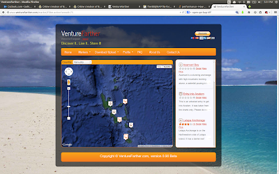
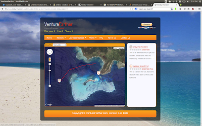
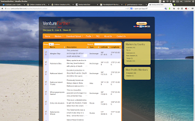
1. VIEW MARKERS FOR ANCHORAGES, ROUTES, DIVE SITES & HIKES
Once you create a username (free & easy), you can see & do everything on the site. You need a username for the community based aspect of the website as well as it's site wide filtering capability. By selecting a country, you can then see markers on a Google Earth map. Go in to any marker to view details including feature icons & user uploaded pictures. Use the filtering feature to see only what you want to see.
2. CREATE NEW MARKERS TO SHARE WITH OTHERS
You can create new markers for things you want to share with others, anywhere in the world as long as you have a GPS coordinate. In fact, this website counts on user contributions to make it grow and to keep it up to date. Put up marker related pictures if you like. You can create markers via GPX uploads from your chart package or manually using the marker creation wizard. When creating a marker, the marker wizard guides you through the creation of it. It's easy!
3. REVIEW & RATE MARKERS
Any user can review & rate a marker. And when a new marker is created by someone, he/she can open up the marker to be edited by anyone or keep the editing to himself. If the marker is open for editing, then updates can be made to keep the data accurate. No one can delete your marker but you. And we all know reviews can really help us out.
4. CREATE YOUR OWN PERSONALIZED E-BOOK ANYTIME YOU WANT
Going to be away from internet? You can create an E-book for yourself and customize it for your needs. Maybe it will be all the markers listed for Vanuatu or maybe you want to focus on just dive sites. Or maybe you just want to sort the markers your friend Bob entered (this is where the username comes in to play) because he's a really good marker creator. You can download as many e-books as you want & even give them as Christmas gifts to your family & friends! Automatically included in the e-book is info on the country & current exchange rate for your personal currency. Every time you create an e-book, it will reflect the latest markers available so there is less chance for stale info as there might be with a traditional cruising guide.
5. DOWNLOAD & UPLOAD GPX FILES
For using the markers within your industry standard charting software, you can download a GPX file for import into your charting package. No more re-typing waypoints! Upload GPX files for creation of new markers to share with others. Do you want to view or share a route for a reef pass or a hike? This is all possible through marker creation as well as GPX file upload.
Well, that's it in a nutshell... for now anyway. What else would you like this website to be? Let us know what you think. We're open to any & all suggestions and will incorporate as much as we can. We have other ideas for further development and will be entering new markers this season as we cruise Vanuatu, New Caledonia & Australia. If you're cruising somewhere on the globe and feel like sharing, by all means, go ahead and enter some too!
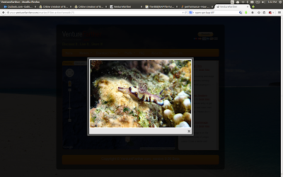
Below are a few screen shots of the website. Or just go to www.VentureFarther.com and see for yourself!
 From VentureFarther.com
 From VentureFarther.com
 From VentureFarther.com
 From VentureFarther.com
Let me introduce you to VentureFather.com.
Jon starting working on this project last season when we were cruising around Vanuatu passing info between friends on dive sites, anchorages & reef passages. He began doing the programming and I began collecting waypoints and info on the things we saw & did. When we haven't been working on the boat or touring around, Jon's had his head down programming up a storm. And to help get us started with some markers for other countries, we have Jon Hacking (S/V Ocelot) & Sherry (S/V Soggy Paws) to thank. After a great deal of work, the website is finally up & running with more development in the works!
So what's special about VentureFarther? Here's what it can do:
1. VIEW MARKERS FOR ANCHORAGES, ROUTES, DIVE SITES & HIKES
Once you create a username (free & easy), you can see & do everything on the site. You need a username for the community based aspect of the website as well as it's site wide filtering capability. By selecting a country, you can then see markers on a Google Earth map. Go in to any marker to view details including feature icons & user uploaded pictures. Use the filtering feature to see only what you want to see.
2. CREATE NEW MARKERS TO SHARE WITH OTHERS
You can create new markers for things you want to share with others, anywhere in the world as long as you have a GPS coordinate. In fact, this website counts on user contributions to make it grow and to keep it up to date. Put up marker related pictures if you like. You can create markers via GPX uploads from your chart package or manually using the marker creation wizard. When creating a marker, the marker wizard guides you through the creation of it. It's easy!
3. REVIEW & RATE MARKERS
Any user can review & rate a marker. And when a new marker is created by someone, he/she can open up the marker to be edited by anyone or keep the editing to himself. If the marker is open for editing, then updates can be made to keep the data accurate. No one can delete your marker but you. And we all know reviews can really help us out.
4. CREATE YOUR OWN PERSONALIZED E-BOOK ANYTIME YOU WANT
Going to be away from internet? You can create an E-book for yourself and customize it for your needs. Maybe it will be all the markers listed for Vanuatu or maybe you want to focus on just dive sites. Or maybe you just want to sort the markers your friend Bob entered (this is where the username comes in to play) because he's a really good marker creator. You can download as many e-books as you want & even give them as Christmas gifts to your family & friends! Automatically included in the e-book is info on the country & current exchange rate for your personal currency. Every time you create an e-book, it will reflect the latest markers available so there is less chance for stale info as there might be with a traditional cruising guide.
5. DOWNLOAD & UPLOAD GPX FILES
For using the markers within your industry standard charting software, you can download a GPX file for import into your charting package. No more re-typing waypoints! Upload GPX files for creation of new markers to share with others. Do you want to view or share a route for a reef pass or a hike? This is all possible through marker creation as well as GPX file upload.
Well, that's it in a nutshell... for now anyway. What else would you like this website to be? Let us know what you think. We're open to any & all suggestions and will incorporate as much as we can. We have other ideas for further development and will be entering new markers this season as we cruise Vanuatu, New Caledonia & Australia. If you're cruising somewhere on the globe and feel like sharing, by all means, go ahead and enter some too!
Below are a few screen shots of the website. Or just go to www.VentureFarther.com and see for yourself!
From VentureFarther.comFrom VentureFarther.comFrom VentureFarther.comFrom VentureFarther.com
Comments
| Vessel Name: | EVERGREEN |
| Vessel Make/Model: | Tashiba 40 Hull #158 |
| Hailing Port: | E. Thetford Vermont |
| Crew: | Heather and Jon Turgeon |
| Extra: |
Gallery not available
Profile for Evergreen and crew
Who: Heather and Jon Turgeon
Port: E. Thetford Vermont
SailBlogs Friends


