S/V Earendil
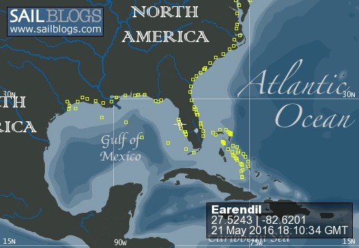
21 May 2016 | Snead Island Boat Works, Manatee River
11 April 2016 | Regatta Pointe Marina, Palmetto, FL
17 March 2016 | Regatta Pointe Marina, Palmetto, FL
02 March 2016 | Regatta Pointe Marina, Palmetto, FL
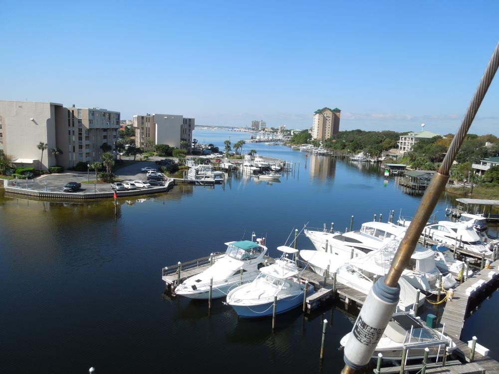
02 March 2016 | Crow's Nest Marina, Venice, FL
21 February 2016 | Ft. Meyers Beach Mooring Field
17 February 2016 | Gulf Harbor Marina, Fort Myers, FL
16 February 2016 | Gulf Harbor Marina, Fort Myers, FL
15 February 2016 | Gulf Harbor Marina, Fort Myers, FL
13 February 2016 | Ft. Meyers Beach Mooring Field
31 January 2016 | Ft. Meyers Beach Mooring Field
25 January 2016 | Burnt Store Marina, FL
21 January 2016 | Platinum Point Yacht Club, Burnt Store Marina, Charlotte Harbor Florida
20 January 2016 | Sarasota Mooring Field
28 December 2015 | Regatta Pointe Marina, Palmetto, FL
16 December 2015 | Regatta Pointe Marina, Palmetto, FL
06 December 2015 | Gulfport Municipal Marina, Gulfport, FL
02 December 2015 | Gulfport Municipal Marina, Gulfport, FL
30 November 2015 | Clearwater Harbor Marina, Clearwater, FL
28 November 2015 | Moorings Marina, Carrabelle, FL
Elizabeth Harbour
17 March 2011 | Elizabeth Harbour
Jill
We sailed into Elizabeth Harbor this afternoon. This is the harbor for Georgetown, but we are probably a mile by dingy from the town. We had a good sail, for the most part. We wanted to leave Little Farmer's Cay as early as we could because we had to go out Farmer's Cut into Exuma Sound. It can be really rough going out the cuts if the wind and current are opposing each other. High tide was at about 6:30 this morning, after that the water starts to flow back out, so the current would be going towards the east, while the wind would be coming from the east. Not good. But, you can't leave until you can see because there's no navigation aids and we don't know the waters. However, the earlier we left, the lighter the current (we hoped) and the wind (again we hoped). So we got up at 5:30 and readied whatever we hadn't been able to do last night. As soon as there was any light at all we took Fuzzy ashore. Then we still had to lift the engine off the dinghy and then lift and stow the dinghy. We managed to leave at about 7:50, which was about as early as I'd want to go (we're on Eastern Daylight Savings time here) as the sun wasn't too far up, and the glare in the water was substantial. I could really only see the bottom about 20 feet in front of the boat, but happily the information we'd gotten on finding the channel was correct, so I never had to ask Bud to change course. The cut was wavy, but really not bad.
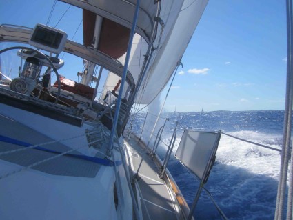
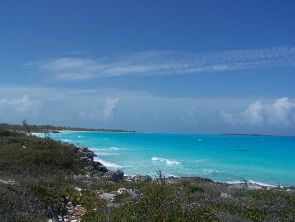
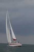
We had quite a sail on the sound. Leaving early was the thing to do as the wind increased all day, as did the waves. The early going was pretty easy, but we were sailing fairly tight to the wind. As the day went on the wind increased and moved a bit further abeam, so Earendil was clipping along at well over 7 knots. That's good time when you consider that the waves by then were 4 to 5 feet. Since Earendil has a low bow, it was a very wet sail. The photo is just after we came up through a wave and the water is pouring off the jib. We did manage to pass a couple of boats that were probably 3 or 4 miles ahead of us when we came out of the cut. That was nice.
The next issue was negotiating the entrance to Elizabeth Harbor. A boater we'd talked to a day or so ago said it wasn't too tough, and the waypoints in the Explorer Chartbook for the Exumas worked well. I had those all entered into the chartplotter last night. Then today, as I was reviewing things before we came in I read the information in our other guidebook. "Don't ever enter Elizabeth Harbor by relying on waypoints." Oh great! Well, we used the waypoints, but of course we also watched the water and we really didn't have any trouble. The hardest part was getting the foresails furled, it was still pretty rough where we took them in, and Bud was having to negotiate the entrance turns. We managed, though.
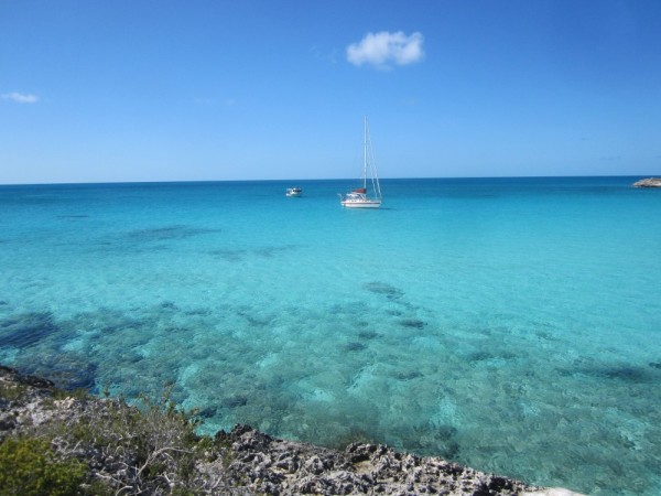
Then we looked ahead and I was somewhat dismayed. There were masts everywhere! We wanted to anchor at Monument Beach, off the west shore of Stocking Island. Stocking Island lies to the east of Great Exuma and the area between these two long islands is Elizabeth Harbor. Since the prevailing winds are from the east and everything in the forecast is from NE to SE, we wanted to be along the west shore of Stocking, rather than the east shore of Great Exuma. So did everyone else. We went along the rows of boats looking for a place to anchor out of the ship channel (not marked, of course) but not in anyone else's way. We finally found a spot and anchored. Once we let out enough chain I thought we were a bit behind the boats on either side. I was worried, the ship channel isn't marked on the chartplotter charts, so we couldn't really tell if we were in it.
Meanwhile, we launched the dinghy, put the engine back on it, loaded up the gas can, paddles, lifejackets, anchor, viewing bucket and Fuzzy and went up to check our anchor and take Fuzzy to the beach. When I looked for the anchor I couldn't find it! We went back and checked and indeed, the Rockna was buried so deep not even the bail was showing, you could just see a little disturbed place where it had dug in (and it looked like it buried itself within a foot of where it landed). That is a stellar anchor! After we took Fuzz for his walk Bud dinghied off to the side to see if we really did stick out. We do, by almost a boat length compared to the people right around us.
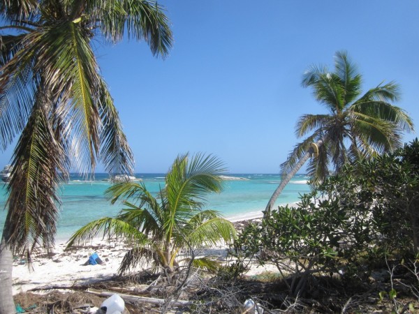
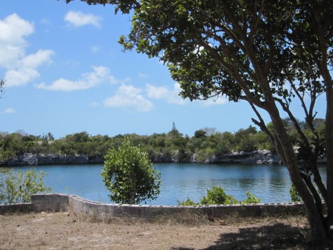
We got back to the boat and finished tidying up the lines and covering the main. Even though we are getting really good at these tasks, it was 4:30 by the time we finished. And we arrived at the anchorage at 2:30. (That's another reason we like to leave as early as we can in the morning. At least with the change in time, and the longer days we have until 7:30 or so before the light really starts to fade.) Anyway, once things were done, we decided to plot our current position per the GPS on the one paper chart that shows a ship channel. Oh, yeah, we're in it. But actually, we're on the edge, and a ferry went by not long after we got here, and other than rocking us a lot with his wake, he didn't seem to have any problems getting by. Maybe if some people move we'll try to move forward, or maybe once we explore the harbor by dinghy we'll see somewhere better to move, but for the moment, we are here. I put photos in the gallery of the "monument" that gives Monument Beach it's name, and the view south of Earendil, with a forest of masts further in the harbor.
We had quite a sail on the sound. Leaving early was the thing to do as the wind increased all day, as did the waves. The early going was pretty easy, but we were sailing fairly tight to the wind. As the day went on the wind increased and moved a bit further abeam, so Earendil was clipping along at well over 7 knots. That's good time when you consider that the waves by then were 4 to 5 feet. Since Earendil has a low bow, it was a very wet sail. The photo is just after we came up through a wave and the water is pouring off the jib. We did manage to pass a couple of boats that were probably 3 or 4 miles ahead of us when we came out of the cut. That was nice.
The next issue was negotiating the entrance to Elizabeth Harbor. A boater we'd talked to a day or so ago said it wasn't too tough, and the waypoints in the Explorer Chartbook for the Exumas worked well. I had those all entered into the chartplotter last night. Then today, as I was reviewing things before we came in I read the information in our other guidebook. "Don't ever enter Elizabeth Harbor by relying on waypoints." Oh great! Well, we used the waypoints, but of course we also watched the water and we really didn't have any trouble. The hardest part was getting the foresails furled, it was still pretty rough where we took them in, and Bud was having to negotiate the entrance turns. We managed, though.
Then we looked ahead and I was somewhat dismayed. There were masts everywhere! We wanted to anchor at Monument Beach, off the west shore of Stocking Island. Stocking Island lies to the east of Great Exuma and the area between these two long islands is Elizabeth Harbor. Since the prevailing winds are from the east and everything in the forecast is from NE to SE, we wanted to be along the west shore of Stocking, rather than the east shore of Great Exuma. So did everyone else. We went along the rows of boats looking for a place to anchor out of the ship channel (not marked, of course) but not in anyone else's way. We finally found a spot and anchored. Once we let out enough chain I thought we were a bit behind the boats on either side. I was worried, the ship channel isn't marked on the chartplotter charts, so we couldn't really tell if we were in it.
Meanwhile, we launched the dinghy, put the engine back on it, loaded up the gas can, paddles, lifejackets, anchor, viewing bucket and Fuzzy and went up to check our anchor and take Fuzzy to the beach. When I looked for the anchor I couldn't find it! We went back and checked and indeed, the Rockna was buried so deep not even the bail was showing, you could just see a little disturbed place where it had dug in (and it looked like it buried itself within a foot of where it landed). That is a stellar anchor! After we took Fuzz for his walk Bud dinghied off to the side to see if we really did stick out. We do, by almost a boat length compared to the people right around us.
We got back to the boat and finished tidying up the lines and covering the main. Even though we are getting really good at these tasks, it was 4:30 by the time we finished. And we arrived at the anchorage at 2:30. (That's another reason we like to leave as early as we can in the morning. At least with the change in time, and the longer days we have until 7:30 or so before the light really starts to fade.) Anyway, once things were done, we decided to plot our current position per the GPS on the one paper chart that shows a ship channel. Oh, yeah, we're in it. But actually, we're on the edge, and a ferry went by not long after we got here, and other than rocking us a lot with his wake, he didn't seem to have any problems getting by. Maybe if some people move we'll try to move forward, or maybe once we explore the harbor by dinghy we'll see somewhere better to move, but for the moment, we are here. I put photos in the gallery of the "monument" that gives Monument Beach it's name, and the view south of Earendil, with a forest of masts further in the harbor.
Comments
| Vessel Name: | Earendil |
| Vessel Make/Model: | Norseman 447 |
| Hailing Port: | Wilson, New York USA |
| Crew: | Bud Campbell & Jill Bebee |
| About: | We are a newly retired couple about to embark for points south. Our crew includes our 14 year old toy poodle, Knaidel, better known as Fuzzy. He is a somewhat reluctant crew member, but would rather sail than stay without us. |
Earendil's Photos - Main
 |
 |
 |
 |
 |
 |
 |
 |
 |
 |
 |
 |
 |
 |
 |
 |
 |
 |
 |
 |
 |
 |
 |
Who We Are
Who: Bud Campbell & Jill Bebee
Port: Wilson, New York USA