'Til the Butter Melts
Pete & Pokey on PRIM
17 August 2010
17 August 2010 | Dowry Creek Marina, NC
16 August 2010
16 August 2010 | Elizabeth City, NC
13 August 2010
12 August 2010 | Deltaville, VA
11 August 2010 | Deltaville, VA
04 August 2010 | Calvert Marina, Solomons
02 August 2010 | Trtacys Landing, MD
15 July 2010 | Tracys Landing, MD
15 February 2010 | Palm Coast
10 January 2010 | St. Augstine
05 January 2010 | St. Augustine
02 January 2010 | New Smryna
24 December 2009
15 December 2009
05 December 2009 | The Riverview Hotel & Marina
30 November 2009 | Daytona - Seven Seas Marina
28 November 2009 | Palm Coast Marina
24 November 2009 | Comachee Cove Yacht Harbor, St. Augustine
At least the bottom was sandy...
28 September 2009 | Alligator River Marina
Pete
The forecast this morning called for 8-10 kts of wind, 1 foot waves, building in mid-afternoon to 20 kts. Someone should check the Sound's wristwatch and the weatherman's coffee cup. The proverbial stink was flying off the dogs by 9:30. Gusts were well above 25 kts and of course this was all straight on the nose. Waves were choppy at 3-4 feet. Blackie and Red were temporarily renamed Emerald and Chartreuse but are rebounding well. Fun day, especially when we finally entered the Alligator River.
Do NOT believe your charts if they are more than 10 minutes old. Green "3" is west of its original position. That has been well-documented in the Waterway Guide, NTM's and other publications. Past that, things changed. Do NOT follow your GPS. Do NOT believe your charts. FOLLOW THE MARKS! When you pass through the gate at Green "6" and Red "7", do NOT zig right and zag left around what the charts show as a potato-shaped shoal south of Red "7". It ain't there! It is now southwest of Green "6" and is something less than 4-10", PRIM's draft. A trawler docked next to us ran up on the same spot earlier today drawing 4 feet. The wind and wave action bounced us back toward Green "6", and I mean right towards it. Within 30 yards of tangling with the mark we bumped back off the shoal and immediately turned south towards Green "9" and all was well again. [i.e., leaving Green "6", head straight for Green "9" and you will be okay.
We are now docked at the Alligator River Marina, fueled up, pumped out, enjoyed a terrific praline ice cream cone and have a load of laundry going. Time to start dinner - ham steak and baked potato, the latter in honor of the shoal that wasn't.
Toddles. Smooth sailing and safe landings (if you enter the Alligator Rv.)
Comments
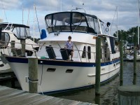
| Vessel Name: | PRIM |
| Vessel Make/Model: | Defever 44 Trawler |
| Hailing Port: | Palm Coast, FL |
| Crew: | Pete & Pokey |
| About: | |
| Extra: | PRIM: 1983 Defever 44 Poof*: 2001 Novurania 360DL Email: Pete.svPrim@yahoo.com |
Gallery not available
PRIM
Who: Pete & Pokey
Port: Palm Coast, FL
SailBlogs Friends

