S/V Uhuru
The excellent adventures of S/V Uhuru.

Never pass up an opportunity to do something extraordinary.
Who: Brian
Port: San Diego, CA
19 February 2019
18 November 2017 | Portobello, Panama
26 August 2017
06 April 2017
06 April 2017
06 April 2017
05 April 2017
05 April 2017
05 April 2017
28 March 2017
11 March 2017
08 March 2017
07 March 2017
05 March 2017
05 March 2017
26 February 2017
25 February 2017
24 February 2017
24 February 2017
A word about charting
01 December 2016
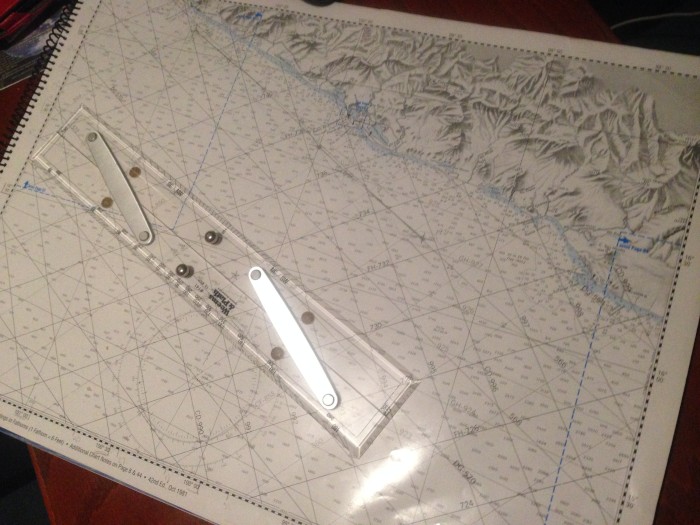
A word about charting
We have two chart plotters on Uhuru, one of them is inside the boat and one is outside. They are linked together and they are FABULOUS!
You may remember when we arrived in Ensenada, that our chart plotter stopped showing detail because we didn't have the Mexico app loaded ☹ We used other means (paper charts and phone apps) until we finally were able to get the one we needed and loaded it.
Chart plotters are great tools. They show you the depth, the detailed sea floor, anchorages, they provide great auto pilots, estimates of arrival, distance to destinations, wind speed, boat speed, latitude and longitude positions, tracks, anchor alarms, time, radar and much more. However, sometimes they are not completely accurate.
When we are cruising, we plot our course into the chart plotter, and use the waypoints to get from place to place, but I also continually chart where we are on a paper chart. I feel more secure knowing that we have a secondary means of seeing where we are. Plus it's old school pirate stuff ☺
Comments
| Vessel Name: | Uhuru |
| Vessel Make/Model: | CT-41 |
| Hailing Port: | San Diego, CA |
| Crew: | Brian |
| Social: |
|
Uhuru's Photos - Main
 |
Never pass up an opportunity to do something extraordinary.
Who: Brian
Port: San Diego, CA