
Swingin' on a Star
Ship's log for the circumnavigating Saint Francis 50 catamaran, "Swingin on a Star".
01 April 2010 | Palau
13 July 2009 | Palau
05 July 2009 | Yacht Harbor
03 July 2009 | Peleliu
02 July 2009 | Palau
01 July 2009 | Two Dog Beach
30 June 2009 | Mecharchar
29 June 2009 | Mecharchar
28 June 2009 | Ulong
27 June 2009 | Ngeruktabel
17 June 2009 | Ngeruktabel
16 June 2009 | Ngeruktabel
15 June 2009 | Ngeruktabel
14 June 2009 | Ngeruktabel
13 June 2009 | Ngerutable
25 May 2009 | Yacht Harbor
30 April 2009 | Malakal
29 April 2009 | Koror
28 April 2009 | Malakal
27 April 2009 | Malakal
Night into Day
16 February 2007 | Provo
Randy
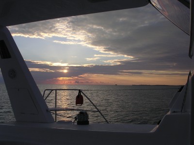
My Nike wrist watch began beeping at 01:15. This is not a civilized hour. Fortunately both Hideko and I had hit the sack at about 8PM the night before. We were amped up with plenty of adrenaline and had no problem waking up. It would be our first night sail without an instructor aboard and certainly the first out in the middle of no where on our own boat. As luck would have it the moon was new (for you land lubbers, that means there was no moon) and it was pitch black out.
We had prepared the night before for our O'Dark Thirty exit with several means to navigate clear of the two entrance reefs. First we had soundings along our track that would guide us out once in the exit channel, tide adjusted of course. The channel runs 10 feet inside the harbor and quickly goes to 30 as you exit. Any shallower and you are going into the anchorage or, less preferably, getting cozy with the reef. Sailing at night by the depth sounder is a tactic highlighted by Bruce Van Sant in his Passages South book and I really see its merits. It is hard to go aground if you're watching the depth, possible, but hard.
Second we had a magnetic heading that would take us all the way out into deep water from our anchor. I used this to line up some stars with our exit heading when the anchor came onto the bow. Neither the compass nor the stars do you any good if you don't start from the expected point. When we brought the anchor up we knew the boat would be pretty much where it was when we dropped it. Any wandering around the anchorage though and the bearing would be useless or even dangerous.
Thirdly we had our chart plotter, and we recorded our entrance track just for kicks. The plotter makes navigating a cake walk of course, unless it is wrong... A bad or slow GPS fix, mismatched datum and several other things that come to mind make me leery of using a plotter for close quarters maneuvers.
It was dark. Really dark. Hideko was taking care of some things below while I brought up the anchor. Then we crept out of the harbor using all three of our tools to ensure everything agreed. Did I mention that it was really dark? Hideko was up on the bow anyway and she could see around us a little. The masthead light made close things easier to see and far things invisible. Even with maximum dimming on the instruments I could not see a thing from the helm.
After a few nail biting minutes the depth, the stars and log, as well as the chart plotter said we were clear. We left the quietly lapping waters of Atwood harbor behind us as we headed out into the greater darkness. A chop had built up during the night and we began to get into a bumpy routine as we moved up to 9 knots under power. It is very strange to have a force, like a moderate chop, working on your boat without having any ability to see it whatsoever.
The radar didn't help much in the harbor but once we were out in the open water the coastline of Acklins came to life on the screen. We had never used our radar before and it was nice to know it worked. It is a Raymarine system and is rated at 24 nautical miles but I found it most effective at 16 nm or less.
We were running without any sails partly because we were nervous about having too many things to cope with on our first night sail, partly because it was too dark to try to get anything flying and largely because it was going to be on the nose as soon as we rounded Acklins and headed down to West Plan Cay. As we came around the tip of Acklins the wind and the chop really built up. The wind was blowing near southeast straight up the channel between Acklins and Plana.
It was a little after 2AM and we were well underway, perhaps making up some for our prior tardiness. We both were really enjoying the new and bizarre nature of sailing, motoring really, without seeing where you are going. For the first hour or two I was checking the instruments every 2.63 seconds. The ocean currents run up to a knot and bend around a lot between the islands. I was glad to have the Radar, Chart Plotter and GPS. The ability to cope with our changing course over ground was important given the substantial currents. Traveling in this kind of dark with just a compass and changing currents would be a very serious challenge.
We always plan our route on paper and then enter it into the ships computer, which then gets downloaded to the E120 chart plotter, giving us triple redundancy. We make passage log entries every half hour with a large set of data. Hideko and I find this far from a hassle. In fact it is a great way to stay up on your plan and keep busy while traveling large distances. We took most of our log ideas from John Rousmaniere's Boater Log. I particularly like his way of plotting the barometric pressure graphically.
As we made our way down toward Plana Cays we picked up a target moving our way on the radar. Shortly thereafter we began to make out a complicated cluster of lights on the horizon. A lot of lights usually means a fishing boat or a tug and barge. It was too far out to make out but we hailed the skipper just to make sure that we stayed clear. It was an ocean tug with a barge in tow. After a short chat with the skipper we agreed to stay on our perspective sides of the channel. He also alerted us to two other targets he had picked up. We never saw the other boats on our screen but we heard one of them on the radio. This is another vote for always having your VHF on 16 when underway, especially at night. You learn a lot about what's around you by just listening to the radio traffic.
Other than the image on the radar screen we never saw the Plana Cays. By dawn we were approaching Mayaguana and I could just make out the thin line of the low lying island across the sun rise. The island disappeared as the sun rose higher in the sky.
As soon as there was decent light we raised the main and pulled out the jib. We have a two part main halyard (thank God) with a block attached to the head board of the main. Unfortunately the block has a swivel base and it seems to want to twist the halyard lines up over night. Raising 60 some feet of fully roached and battened main sail is a chore. I can use the electric windless but it is tricky to tail and hard to watch the tailing on the windless and the main battens, etceteras, at the same time. Hideko always wants me to use the winch to get a work out anyway. As I got the main up near the top I noticed the halyard was twisted again. Ug. You can't raise the sail all the way with more than one or two twists in the halyard and I had a good five. So, lower the main all the way and straighten out the halyard or take it up to the first reef and call it a day. One reef it was.
I brought the jib in as flat as possible moving the block all the way back on the track and I flattened out the main with the traveler a little to windward. The sails gave us another half knot or so but we were very close to the wind. We didn't have time to tack so we just hunkered down at about 10 knots and continued on toward the Sand Bore waypoint at the entrance to the Caicos Banks. I dropped our Bahamas flag for the first time in over two months and raised the quarantine flag.
Hideko and I traded off at the helm as we used up the last bit of the morning. West Caicos came into view first and then Providenciales shortly there after. We had an ETA of 13:30 at the Sand Bore, surprisingly, right on time. It is about eight miles east over the banks to the Sapoldilla Bay anchorage so you want plenty of light to get in with. If the trades are blowing this could take a while. We had the luxury of a southwest wind and good light with only a few clouds in the sky. We dropped the sails at the way point and headed for the light green water.
Entering a new bank is always nerve wracking to me. The charts show rocks and shoals everywhere and the deep water is 12 feet. We were both a little tired so we had to really focus to keep on top of things. Hideko went up to the bow to spot and I motored us into the cut. It was a beautiful day but very hot and Hideko cooking on the bow. We motored in at 5 knots and after a half hour of seeing eight to ten feet on the sounder we got used to the skinny water and moved up to 7 knots.
The islands looked beautiful as we approached. Unfortunately the south side of Provo is not quite the same as the north side. It is pretty from afar with low rocky headlands and there's a large rock on the way into the main anchorage known as turtle rock but as you approach Sapodilla Bay, the only real anchorage on the south side of Provo, the luster begins to dim.
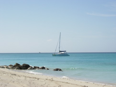
All of the other cruising boats were anchored on the north east side of the anchorage in the area of the beach. We drove around the anchorage checking the depth and noticed a sunken sail boat in the middle of the bay with a red bouy on it. There were some dodgy vessels in the anchorage. A couple looked like they were barely floating. There were also some very nice sailboats and a custom schooner that was particularly pretty.
The entire area seemed to have six or seven feet of water as long as you didn't get too close to the shore. We decided to anchor by ourselves over in the north west part of the anchorage due to the 20 some knot winds expected from that direction. We were hoping the small bluff would afford us a little lee. We also wanted plenty of swinging room because we just put down one anchor.
The government dock is just around the point and it has container barges going in and out and forklifts running all day. The beach at Sapodilla has houses all across it, making you feel a little like a trespasser when you go ashore. Once ashore I discovered that the locals had also decided to use the beach as a dumping ground. There was trash everywhere and stray dogs wandering about. I was sad to see the odd plastic wrapper or piece of wire here and there in the Bahamas, but compared to this the Bahamas is pristine. I would not go ashore without shoes here. Provo is supposedly the Nassau of the TCI so perhaps the rest of the island is nicer.
I hailed the Dockmaster on 16 per the cruising guide to await instruction on entry. It was 15:30 on Friday. No answer. I tried again three more times and by 5PM gave up. We were quarantined until Monday morning! Hanging out on the boat was not exactly our plan for the weekend but with the in climate weather predicted it would be a nice break. A dingy with three kids aboard came by to say hi and see if we wanted to buy some necklaces they made with twine and shells. They were very impressive and Hideko bought a nice one for $5.
It had been a long but fun day and our first at over 100 miles.
We had prepared the night before for our O'Dark Thirty exit with several means to navigate clear of the two entrance reefs. First we had soundings along our track that would guide us out once in the exit channel, tide adjusted of course. The channel runs 10 feet inside the harbor and quickly goes to 30 as you exit. Any shallower and you are going into the anchorage or, less preferably, getting cozy with the reef. Sailing at night by the depth sounder is a tactic highlighted by Bruce Van Sant in his Passages South book and I really see its merits. It is hard to go aground if you're watching the depth, possible, but hard.
Second we had a magnetic heading that would take us all the way out into deep water from our anchor. I used this to line up some stars with our exit heading when the anchor came onto the bow. Neither the compass nor the stars do you any good if you don't start from the expected point. When we brought the anchor up we knew the boat would be pretty much where it was when we dropped it. Any wandering around the anchorage though and the bearing would be useless or even dangerous.
Thirdly we had our chart plotter, and we recorded our entrance track just for kicks. The plotter makes navigating a cake walk of course, unless it is wrong... A bad or slow GPS fix, mismatched datum and several other things that come to mind make me leery of using a plotter for close quarters maneuvers.
It was dark. Really dark. Hideko was taking care of some things below while I brought up the anchor. Then we crept out of the harbor using all three of our tools to ensure everything agreed. Did I mention that it was really dark? Hideko was up on the bow anyway and she could see around us a little. The masthead light made close things easier to see and far things invisible. Even with maximum dimming on the instruments I could not see a thing from the helm.
After a few nail biting minutes the depth, the stars and log, as well as the chart plotter said we were clear. We left the quietly lapping waters of Atwood harbor behind us as we headed out into the greater darkness. A chop had built up during the night and we began to get into a bumpy routine as we moved up to 9 knots under power. It is very strange to have a force, like a moderate chop, working on your boat without having any ability to see it whatsoever.
The radar didn't help much in the harbor but once we were out in the open water the coastline of Acklins came to life on the screen. We had never used our radar before and it was nice to know it worked. It is a Raymarine system and is rated at 24 nautical miles but I found it most effective at 16 nm or less.
We were running without any sails partly because we were nervous about having too many things to cope with on our first night sail, partly because it was too dark to try to get anything flying and largely because it was going to be on the nose as soon as we rounded Acklins and headed down to West Plan Cay. As we came around the tip of Acklins the wind and the chop really built up. The wind was blowing near southeast straight up the channel between Acklins and Plana.
It was a little after 2AM and we were well underway, perhaps making up some for our prior tardiness. We both were really enjoying the new and bizarre nature of sailing, motoring really, without seeing where you are going. For the first hour or two I was checking the instruments every 2.63 seconds. The ocean currents run up to a knot and bend around a lot between the islands. I was glad to have the Radar, Chart Plotter and GPS. The ability to cope with our changing course over ground was important given the substantial currents. Traveling in this kind of dark with just a compass and changing currents would be a very serious challenge.
We always plan our route on paper and then enter it into the ships computer, which then gets downloaded to the E120 chart plotter, giving us triple redundancy. We make passage log entries every half hour with a large set of data. Hideko and I find this far from a hassle. In fact it is a great way to stay up on your plan and keep busy while traveling large distances. We took most of our log ideas from John Rousmaniere's Boater Log. I particularly like his way of plotting the barometric pressure graphically.
As we made our way down toward Plana Cays we picked up a target moving our way on the radar. Shortly thereafter we began to make out a complicated cluster of lights on the horizon. A lot of lights usually means a fishing boat or a tug and barge. It was too far out to make out but we hailed the skipper just to make sure that we stayed clear. It was an ocean tug with a barge in tow. After a short chat with the skipper we agreed to stay on our perspective sides of the channel. He also alerted us to two other targets he had picked up. We never saw the other boats on our screen but we heard one of them on the radio. This is another vote for always having your VHF on 16 when underway, especially at night. You learn a lot about what's around you by just listening to the radio traffic.
Other than the image on the radar screen we never saw the Plana Cays. By dawn we were approaching Mayaguana and I could just make out the thin line of the low lying island across the sun rise. The island disappeared as the sun rose higher in the sky.
As soon as there was decent light we raised the main and pulled out the jib. We have a two part main halyard (thank God) with a block attached to the head board of the main. Unfortunately the block has a swivel base and it seems to want to twist the halyard lines up over night. Raising 60 some feet of fully roached and battened main sail is a chore. I can use the electric windless but it is tricky to tail and hard to watch the tailing on the windless and the main battens, etceteras, at the same time. Hideko always wants me to use the winch to get a work out anyway. As I got the main up near the top I noticed the halyard was twisted again. Ug. You can't raise the sail all the way with more than one or two twists in the halyard and I had a good five. So, lower the main all the way and straighten out the halyard or take it up to the first reef and call it a day. One reef it was.
I brought the jib in as flat as possible moving the block all the way back on the track and I flattened out the main with the traveler a little to windward. The sails gave us another half knot or so but we were very close to the wind. We didn't have time to tack so we just hunkered down at about 10 knots and continued on toward the Sand Bore waypoint at the entrance to the Caicos Banks. I dropped our Bahamas flag for the first time in over two months and raised the quarantine flag.
Hideko and I traded off at the helm as we used up the last bit of the morning. West Caicos came into view first and then Providenciales shortly there after. We had an ETA of 13:30 at the Sand Bore, surprisingly, right on time. It is about eight miles east over the banks to the Sapoldilla Bay anchorage so you want plenty of light to get in with. If the trades are blowing this could take a while. We had the luxury of a southwest wind and good light with only a few clouds in the sky. We dropped the sails at the way point and headed for the light green water.
Entering a new bank is always nerve wracking to me. The charts show rocks and shoals everywhere and the deep water is 12 feet. We were both a little tired so we had to really focus to keep on top of things. Hideko went up to the bow to spot and I motored us into the cut. It was a beautiful day but very hot and Hideko cooking on the bow. We motored in at 5 knots and after a half hour of seeing eight to ten feet on the sounder we got used to the skinny water and moved up to 7 knots.
The islands looked beautiful as we approached. Unfortunately the south side of Provo is not quite the same as the north side. It is pretty from afar with low rocky headlands and there's a large rock on the way into the main anchorage known as turtle rock but as you approach Sapodilla Bay, the only real anchorage on the south side of Provo, the luster begins to dim.
All of the other cruising boats were anchored on the north east side of the anchorage in the area of the beach. We drove around the anchorage checking the depth and noticed a sunken sail boat in the middle of the bay with a red bouy on it. There were some dodgy vessels in the anchorage. A couple looked like they were barely floating. There were also some very nice sailboats and a custom schooner that was particularly pretty.
The entire area seemed to have six or seven feet of water as long as you didn't get too close to the shore. We decided to anchor by ourselves over in the north west part of the anchorage due to the 20 some knot winds expected from that direction. We were hoping the small bluff would afford us a little lee. We also wanted plenty of swinging room because we just put down one anchor.
The government dock is just around the point and it has container barges going in and out and forklifts running all day. The beach at Sapodilla has houses all across it, making you feel a little like a trespasser when you go ashore. Once ashore I discovered that the locals had also decided to use the beach as a dumping ground. There was trash everywhere and stray dogs wandering about. I was sad to see the odd plastic wrapper or piece of wire here and there in the Bahamas, but compared to this the Bahamas is pristine. I would not go ashore without shoes here. Provo is supposedly the Nassau of the TCI so perhaps the rest of the island is nicer.
I hailed the Dockmaster on 16 per the cruising guide to await instruction on entry. It was 15:30 on Friday. No answer. I tried again three more times and by 5PM gave up. We were quarantined until Monday morning! Hanging out on the boat was not exactly our plan for the weekend but with the in climate weather predicted it would be a nice break. A dingy with three kids aboard came by to say hi and see if we wanted to buy some necklaces they made with twine and shells. They were very impressive and Hideko bought a nice one for $5.
It had been a long but fun day and our first at over 100 miles.
Comments
| Vessel Name: | Swingin' on a Star |
| Vessel Make/Model: | Saint Francis 50 |
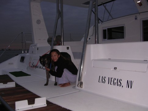
| Hailing Port: | Las Vegas, NV |
| Crew: | Randy Abernethy |
| Home Page: | http://swinginonastar.com |
Swingin' on a Star's Photos - Swingin on a Star (Main)
 |
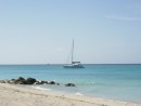
Selected photos of Swingin' on a Star at anchor.
7 Photos
Created 18 September 2007
|
 |
Swingin on a Star
Who: Randy Abernethy
Port: Las Vegas, NV
Gallery

History
Links
SailBlogs Friends

