Log of Taiga
29 April 2014 | 14 05'N:060 57.7'E, Rodney Bay, St Lucia
27 April 2014 | 16 18.5'N:061 47.9'E, Deshaies, Guadeloupe
27 April 2014 | 17 09.1'N:062 37.9'E, Island of Nevis
27 April 2014 | 17 15'N:062 39.6'E, Island of St. Christopher
27 April 2014 | 17 55.5'N:062 52.2'E, Island of St. Barthelemy
07 April 2014 | 18 03'N:063 05.9'E, Island of St. Martin
07 April 2014 | 18 29.9'N:064 23.2'E, Norman Island to North Gorda Sound
07 April 2014 | 18 19.1'N:064 37.1'E, Soper's Hole, then Norman Island
05 April 2014 | 18 20.6'N:064 40.7'E, Round Bay, St. Johns, USVI
05 April 2014 | 18 20'N:064 58'E, St. Thomas, USVI
05 April 2014 | 18 18.4'N:065 17.8'E, Culebra Island, PR
05 April 2014 | 18 8.1'N:065 18'E, Bahia Salinas del Sur, Vieques
05 April 2014 | 18 5.5'N:065 28.2'E, Esperanza, Vieques
05 April 2014 | 17 57.5'N:066 17.5'E, Salinas, Puerto Rico
05 April 2014 | 17 53.2'N:066 31.8'E, Isla Caja de Muertos
05 April 2014 | 17 56.7'N:066 52.4'E, Bahia Guanica, P.R.
05 April 2014 | 18 04.5'N:067 11.3'E, Puerto Real, P.R.
08 March 2014 | 18 04.5'N:067 11.3'E, Puerto Real, P.R.
08 March 2014 | 19 17.2'N:069 19.8'E, Puerto del Valle
27 February 2014 | 19 24'N:069 45'E, Luperon to Puerto del Valle
Nevis to Guadeloupe, 70 NM
27 April 2014 | 16 18.5'N:061 47.9'E, Deshaies, Guadeloupe
Jack
Tuesday, April 15, 2014 Off the mooring ball at Nevis at 6 am for the 70 mile sail to Guadeloupe. In the morning lee of the island there was almost no wind, but as we rounded the south tip we got wind and seas. We quickly headed up and put in a reef, then headed SE for the north tip of Montserrat. We decided to skip that island on this trip, because there was a pretty big NE swell running, and the open roadstead at Little Bay, Montserrat is reported bad in those conditions, and landing a dinghy in the surf would be dangerous. When we rounded the northern end of Montserrat we turned to coast along the east side of the island. The wind was just great now, running 16 knots right on the beam, so we shook out the reef and took off. This was dreamlike sailing with gentle seas, the volcanic island rising up to our starboard side, sun shining. We let the autopilot do the driving and repaired to the trampoline up front to enjoy the ride.
We could see steam rising from the heights of Soufriere Hills volcano, which erupted in 1995, burying the main town of Plymouth in several feet of hot ash from a pyroclastic flow. We could also identify the remains of a sugar mill and plantation house on an island of green that was left intact as the ash flowed down the valleys on either side. The ash flow includes many angular boulders the size of houses.
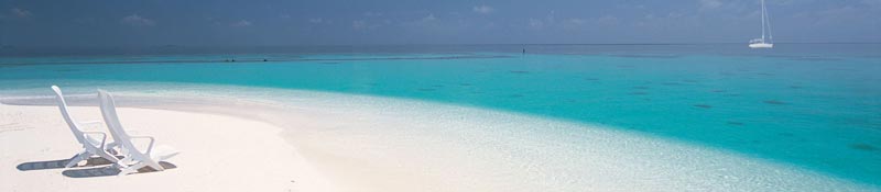
Deshaies, Guadeloupe We pulled into the tiny, protected anchorage at Deshaies (pronounced Day Ay), Guadeloupe. Another volcanic island, and the highest point is another Soufriere volcano. This one with steam vents visible when the clouds part. We got Taiga settled on her anchor and went ashore to check in. The French have a very sensible check-in system: it's done a computer in a small tourist shop. Pay the man 4 euros and you're done.
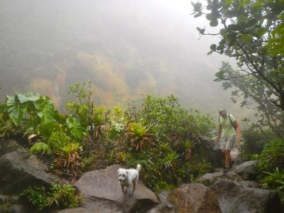
On Wednesday with Edgar and Hella, we took a hike up the Deshaies River, that flows through the town and empties into the bay. Really, it's a creek, but a lovely boulder scramble in the shade of the overhanging trees as you go up, up, up the creek bed, crossing and recrossing the tumbling stream as the mountain slopes rise on either side. The tropical rainforest here is full of birds, and it felt great to be stretching our legs and bodies. In a couple of hours, we reached a road that crosses near the headwaters, and we took this back into town, passing a Catholic retreat center, with beautiful landscaped grounds. Quite a surprise after our wild scramble up the creek below, where we saw no sign of this area hidden on the forested slopes above us.
On Friday the four of us took a bus about 5 miles north to Fort Royal to pick up a rental car at the hotel there. We discovered that if we reserved it online for three days we'd save 100 euros over the same car and rental period if we just walked in and rented it. So the charges were 124 euros with insurance, plus fill the tank with gas at the end, which came out to another 41 euros.
We drove the highway around the north end of Basse Terre, the mountainous part of this roughly butterfly-shaped island. Grande Terre is bigger, but flat. We could see Grand Terre from the mountains during our later hikes, but we never went there. For the next three days we took different drives to scenic spots each day, and got out and hiked. This has been a period of strong tradewinds and pretty heavy rainsquall activity, so the mountains have mainly been in the clouds.
Saturday we decided to drive to Guadeloupe's Soufriere Volcano National Park for a hike to the top. What a day! The road is paved all the way to the parking area, although it is very narrow, with several tight switchbacks. At the parking lot our rented Nissan couldn't muster the engine power to make the last grade, so everyone else piled out into the rain and I clutched it into a parking spot. The path up out of the parking lot is beautifully done in cobblestones with many areas of stairsteps and wooden bridges across the water courses. The whole way we were in either heavy mist or driving rain and the wind was whipping. As we climbed, the groomed trail petered out and it turned into a steep, rocky scramble, with slippery mud patches. We also climbed out of the rainforest into a scrub forest. Everything was dripping. As we neared the final pitch about 1 1/2 hours into the hike, Sherri and Hella took a look at the next steep pitch and decided to head back down. By now it was o bvious we would see only mist and fog at the summit, as well as being exposed to the strong, gusty winds on a vertical, muddy, rocky trail. Theirs was a good decision, as Edgar and I should have known. At the summit the winds were so strong that each gust would stagger you, and sure enough, even standing on the edge of one of the volcanic fissures, we could see nothing through the fog and rain, although we could sometimes smell the strong sulphur from the vents. We beat a hasty retreat, proud we'd toughed it out, but wondering why. Of course, going down was much tougher than going up, especially in my flip-flops. In some places I just went barefoot for safety. We were carrying umbrellas, but they were utterly useless in these conditions, so we were all absolutely soaked to the skin.
We caught up with Sherri, Hella and Toby, looking like tornado survivors partway down the mountain, and we were only too glad to get back in the car and head down out of the clouds and rain for a rewarding ice cream at a shop on the beach.
On Sunday we drove the Basse Terre Traverse highway and it was a beautiful day. We took two hikes, one to the Mamelle Pigeon ridgetop, another steep, muddy path; the other along the Bras David River, through the lower level rainforest. Really spectacular. There some huge trees here, and all the trees, large and small are festooned with various species of epiphyte plants and streamers and vines. It is really a grand place. We ended our hike at the river where we flaked out on the rocks after washing the mud off ourselves and Toby.
We could see steam rising from the heights of Soufriere Hills volcano, which erupted in 1995, burying the main town of Plymouth in several feet of hot ash from a pyroclastic flow. We could also identify the remains of a sugar mill and plantation house on an island of green that was left intact as the ash flowed down the valleys on either side. The ash flow includes many angular boulders the size of houses.
Deshaies, Guadeloupe We pulled into the tiny, protected anchorage at Deshaies (pronounced Day Ay), Guadeloupe. Another volcanic island, and the highest point is another Soufriere volcano. This one with steam vents visible when the clouds part. We got Taiga settled on her anchor and went ashore to check in. The French have a very sensible check-in system: it's done a computer in a small tourist shop. Pay the man 4 euros and you're done.
On Wednesday with Edgar and Hella, we took a hike up the Deshaies River, that flows through the town and empties into the bay. Really, it's a creek, but a lovely boulder scramble in the shade of the overhanging trees as you go up, up, up the creek bed, crossing and recrossing the tumbling stream as the mountain slopes rise on either side. The tropical rainforest here is full of birds, and it felt great to be stretching our legs and bodies. In a couple of hours, we reached a road that crosses near the headwaters, and we took this back into town, passing a Catholic retreat center, with beautiful landscaped grounds. Quite a surprise after our wild scramble up the creek below, where we saw no sign of this area hidden on the forested slopes above us.
On Friday the four of us took a bus about 5 miles north to Fort Royal to pick up a rental car at the hotel there. We discovered that if we reserved it online for three days we'd save 100 euros over the same car and rental period if we just walked in and rented it. So the charges were 124 euros with insurance, plus fill the tank with gas at the end, which came out to another 41 euros.
We drove the highway around the north end of Basse Terre, the mountainous part of this roughly butterfly-shaped island. Grande Terre is bigger, but flat. We could see Grand Terre from the mountains during our later hikes, but we never went there. For the next three days we took different drives to scenic spots each day, and got out and hiked. This has been a period of strong tradewinds and pretty heavy rainsquall activity, so the mountains have mainly been in the clouds.
Saturday we decided to drive to Guadeloupe's Soufriere Volcano National Park for a hike to the top. What a day! The road is paved all the way to the parking area, although it is very narrow, with several tight switchbacks. At the parking lot our rented Nissan couldn't muster the engine power to make the last grade, so everyone else piled out into the rain and I clutched it into a parking spot. The path up out of the parking lot is beautifully done in cobblestones with many areas of stairsteps and wooden bridges across the water courses. The whole way we were in either heavy mist or driving rain and the wind was whipping. As we climbed, the groomed trail petered out and it turned into a steep, rocky scramble, with slippery mud patches. We also climbed out of the rainforest into a scrub forest. Everything was dripping. As we neared the final pitch about 1 1/2 hours into the hike, Sherri and Hella took a look at the next steep pitch and decided to head back down. By now it was o bvious we would see only mist and fog at the summit, as well as being exposed to the strong, gusty winds on a vertical, muddy, rocky trail. Theirs was a good decision, as Edgar and I should have known. At the summit the winds were so strong that each gust would stagger you, and sure enough, even standing on the edge of one of the volcanic fissures, we could see nothing through the fog and rain, although we could sometimes smell the strong sulphur from the vents. We beat a hasty retreat, proud we'd toughed it out, but wondering why. Of course, going down was much tougher than going up, especially in my flip-flops. In some places I just went barefoot for safety. We were carrying umbrellas, but they were utterly useless in these conditions, so we were all absolutely soaked to the skin.
We caught up with Sherri, Hella and Toby, looking like tornado survivors partway down the mountain, and we were only too glad to get back in the car and head down out of the clouds and rain for a rewarding ice cream at a shop on the beach.
On Sunday we drove the Basse Terre Traverse highway and it was a beautiful day. We took two hikes, one to the Mamelle Pigeon ridgetop, another steep, muddy path; the other along the Bras David River, through the lower level rainforest. Really spectacular. There some huge trees here, and all the trees, large and small are festooned with various species of epiphyte plants and streamers and vines. It is really a grand place. We ended our hike at the river where we flaked out on the rocks after washing the mud off ourselves and Toby.
Comments
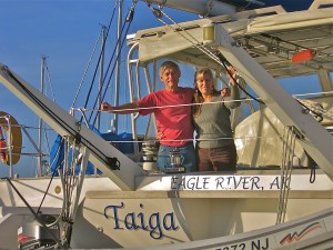
| Vessel Name: | Taiga |
| Vessel Make/Model: | Catana 44 |
| Hailing Port: | Eagle River, Alaska |
| Crew: | Jack and Sherri Hayden |
| About: | Taiga is a 1997 Catana 44 catamaran. We bought her in November, 2010 in Hampton, Virginia. This is our second sailboat and we love it. It is fast and comfortable. |
Gallery not available
Crew of Taiga
Who: Jack and Sherri Hayden
Port: Eagle River, Alaska