Log of Taiga
04 May 2013 | 'N: 'W, 03/25/2013
04 May 2013 | 21 04.8'N:075 57.6'W, 03/24/2013
04 May 2013 | 21 04.8'N:075 57.6'W, 03/25/2013
04 May 2013 | 21 04.8'N:075 57.6'W, 03/23/2013
04 May 2013 | 22 20.9'N:075 47.9'W, 03/22/2013
02 May 2013 | 22 52.8'N:075 52.1'W, 03/22/2013
02 May 2013 | 23 01.7'N:075 42.9'W, 03/1/2013
01 May 2013 | 23 25.1'N:075 08'W, 03/16/2013
01 May 2013 | 23 25.1'N:075 08'W, 03/15/2013
01 May 2013 | 23 25.1'N:075 08'W, 03/10/2013
09 March 2013 | 23 25.1'N:075 08'W, 03/09/2013
09 March 2013 | 23 29.1'N:075 44.3'W, 03/08/2013
09 March 2013 | 23 29.1'N:075 44.3'W, 03/05/2013
09 March 2013 | 23 29.1'N:075 44.3'W, 03/05/2013
09 March 2013 | 23 29.1'N:075 44.3'W, 03/05/2013
04 March 2013 | 23 29.1'N:075 44.3'W, 03/04/2013
19 February 2013 | 23 29.1'N:075 44.3'W, 02/19/2013
12 February 2013 | 23 29.1'N:075 44.3'W, 02/12/2013
12 February 2013 | 21 53.4'N:076 13.6'W, 01/30/2013
12 February 2013 | 23 51.8'N:076 24.2'W, 01/29/2013
Moving South
29 April 2014 | 14 05'N:060 57.7'E, Rodney Bay, St Lucia
Jack
April 29, 2014 Brief temporary update: we're moving a little faster now, because we are scheduled to haul Taiga out for hurricane season storage in Trinidad on May 20, now three weeks away. So as of right now, we're sitting in a nice seaside bar in Rodney Bay, St. Lucia, catching up on emails. Since our last post, we sailed to the island of Dominica and spent a few days in the bay in Portsmouth, taking a fine hike on our own up a small river one day and also taking a taxi tour of the island with a guide and two other cruiser couples another day. Then we sailed to St. Pierre, Martinique and spent two days, one of which we hiked up a long steep road to the DePaz rum distillery for a tour and tasting. Scott, brace yourself, we're bringing you a bottle of their best....if we don't make planter's punch out of it first. Today we sailed 42 miles to Rodney Bay. Once again, the forecast was for 15 knots of wind and we never saw less than 21 all day, and some fine, rolling seas, too. We checked in and out with Customs and Immigration this afternoon. Tomorrow we'll come in for fuel then sail to the south end of this island to Vieux Fort to spend a night, then Thursday we'll sail for Bequia, part of St. Vincent and the Grenadines. More later, with pictures. We've done several dives and need to edit photos before posting.
Nevis to Guadeloupe, 70 NM
27 April 2014 | 16 18.5'N:061 47.9'E, Deshaies, Guadeloupe
Jack
Tuesday, April 15, 2014 Off the mooring ball at Nevis at 6 am for the 70 mile sail to Guadeloupe. In the morning lee of the island there was almost no wind, but as we rounded the south tip we got wind and seas. We quickly headed up and put in a reef, then headed SE for the north tip of Montserrat. We decided to skip that island on this trip, because there was a pretty big NE swell running, and the open roadstead at Little Bay, Montserrat is reported bad in those conditions, and landing a dinghy in the surf would be dangerous. When we rounded the northern end of Montserrat we turned to coast along the east side of the island. The wind was just great now, running 16 knots right on the beam, so we shook out the reef and took off. This was dreamlike sailing with gentle seas, the volcanic island rising up to our starboard side, sun shining. We let the autopilot do the driving and repaired to the trampoline up front to enjoy the ride.
We could see steam rising from the heights of Soufriere Hills volcano, which erupted in 1995, burying the main town of Plymouth in several feet of hot ash from a pyroclastic flow. We could also identify the remains of a sugar mill and plantation house on an island of green that was left intact as the ash flowed down the valleys on either side. The ash flow includes many angular boulders the size of houses.
Deshaies, Guadeloupe We pulled into the tiny, protected anchorage at Deshaies (pronounced Day Ay), Guadeloupe. Another volcanic island, and the highest point is another Soufriere volcano. This one with steam vents visible when the clouds part. We got Taiga settled on her anchor and went ashore to check in. The French have a very sensible check-in system: it's done a computer in a small tourist shop. Pay the man 4 euros and you're done.
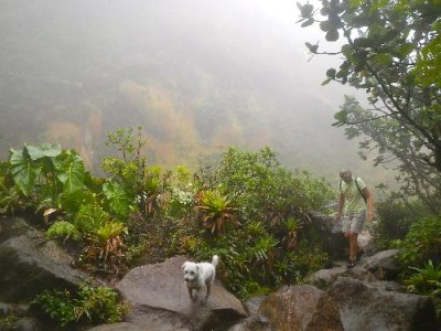
On Wednesday with Edgar and Hella, we took a hike up the Deshaies River, that flows through the town and empties into the bay. Really, it's a creek, but a lovely boulder scramble in the shade of the overhanging trees as you go up, up, up the creek bed, crossing and recrossing the tumbling stream as the mountain slopes rise on either side. The tropical rainforest here is full of birds, and it felt great to be stretching our legs and bodies. In a couple of hours, we reached a road that crosses near the headwaters, and we took this back into town, passing a Catholic retreat center, with beautiful landscaped grounds. Quite a surprise after our wild scramble up the creek below, where we saw no sign of this area hidden on the forested slopes above us.
On Friday the four of us took a bus about 5 miles north to Fort Royal to pick up a rental car at the hotel there. We discovered that if we reserved it online for three days we'd save 100 euros over the same car and rental period if we just walked in and rented it. So the charges were 124 euros with insurance, plus fill the tank with gas at the end, which came out to another 41 euros.
We drove the highway around the north end of Basse Terre, the mountainous part of this roughly butterfly-shaped island. Grande Terre is bigger, but flat. We could see Grand Terre from the mountains during our later hikes, but we never went there. For the next three days we took different drives to scenic spots each day, and got out and hiked. This has been a period of strong tradewinds and pretty heavy rainsquall activity, so the mountains have mainly been in the clouds.
Saturday we decided to drive to Guadeloupe's Soufriere Volcano National Park for a hike to the top. What a day! The road is paved all the way to the parking area, although it is very narrow, with several tight switchbacks. At the parking lot our rented Nissan couldn't muster the engine power to make the last grade, so everyone else piled out into the rain and I clutched it into a parking spot. The path up out of the parking lot is beautifully done in cobblestones with many areas of stairsteps and wooden bridges across the water courses. The whole way we were in either heavy mist or driving rain and the wind was whipping. As we climbed, the groomed trail petered out and it turned into a steep, rocky scramble, with slippery mud patches. We also climbed out of the rainforest into a scrub forest. Everything was dripping. As we neared the final pitch about 1 1/2 hours into the hike, Sherri and Hella took a look at the next steep pitch and decided to head back down. By now it was o bvious we would see only mist and fog at the summit, as well as being exposed to the strong, gusty winds on a vertical, muddy, rocky trail. Theirs was a good decision, as Edgar and I should have known. At the summit the winds were so strong that each gust would stagger you, and sure enough, even standing on the edge of one of the volcanic fissures, we could see nothing through the fog and rain, although we could sometimes smell the strong sulphur from the vents. We beat a hasty retreat, proud we'd toughed it out, but wondering why. Of course, going down was much tougher than going up, especially in my flip-flops. In some places I just went barefoot for safety. We were carrying umbrellas, but they were utterly useless in these conditions, so we were all absolutely soaked to the skin.
We caught up with Sherri, Hella and Toby, looking like tornado survivors partway down the mountain, and we were only too glad to get back in the car and head down out of the clouds and rain for a rewarding ice cream at a shop on the beach.
On Sunday we drove the Basse Terre Traverse highway and it was a beautiful day. We took two hikes, one to the Mamelle Pigeon ridgetop, another steep, muddy path; the other along the Bras David River, through the lower level rainforest. Really spectacular. There some huge trees here, and all the trees, large and small are festooned with various species of epiphyte plants and streamers and vines. It is really a grand place. We ended our hike at the river where we flaked out on the rocks after washing the mud off ourselves and Toby.
We could see steam rising from the heights of Soufriere Hills volcano, which erupted in 1995, burying the main town of Plymouth in several feet of hot ash from a pyroclastic flow. We could also identify the remains of a sugar mill and plantation house on an island of green that was left intact as the ash flowed down the valleys on either side. The ash flow includes many angular boulders the size of houses.
Deshaies, Guadeloupe We pulled into the tiny, protected anchorage at Deshaies (pronounced Day Ay), Guadeloupe. Another volcanic island, and the highest point is another Soufriere volcano. This one with steam vents visible when the clouds part. We got Taiga settled on her anchor and went ashore to check in. The French have a very sensible check-in system: it's done a computer in a small tourist shop. Pay the man 4 euros and you're done.
On Wednesday with Edgar and Hella, we took a hike up the Deshaies River, that flows through the town and empties into the bay. Really, it's a creek, but a lovely boulder scramble in the shade of the overhanging trees as you go up, up, up the creek bed, crossing and recrossing the tumbling stream as the mountain slopes rise on either side. The tropical rainforest here is full of birds, and it felt great to be stretching our legs and bodies. In a couple of hours, we reached a road that crosses near the headwaters, and we took this back into town, passing a Catholic retreat center, with beautiful landscaped grounds. Quite a surprise after our wild scramble up the creek below, where we saw no sign of this area hidden on the forested slopes above us.
On Friday the four of us took a bus about 5 miles north to Fort Royal to pick up a rental car at the hotel there. We discovered that if we reserved it online for three days we'd save 100 euros over the same car and rental period if we just walked in and rented it. So the charges were 124 euros with insurance, plus fill the tank with gas at the end, which came out to another 41 euros.
We drove the highway around the north end of Basse Terre, the mountainous part of this roughly butterfly-shaped island. Grande Terre is bigger, but flat. We could see Grand Terre from the mountains during our later hikes, but we never went there. For the next three days we took different drives to scenic spots each day, and got out and hiked. This has been a period of strong tradewinds and pretty heavy rainsquall activity, so the mountains have mainly been in the clouds.
Saturday we decided to drive to Guadeloupe's Soufriere Volcano National Park for a hike to the top. What a day! The road is paved all the way to the parking area, although it is very narrow, with several tight switchbacks. At the parking lot our rented Nissan couldn't muster the engine power to make the last grade, so everyone else piled out into the rain and I clutched it into a parking spot. The path up out of the parking lot is beautifully done in cobblestones with many areas of stairsteps and wooden bridges across the water courses. The whole way we were in either heavy mist or driving rain and the wind was whipping. As we climbed, the groomed trail petered out and it turned into a steep, rocky scramble, with slippery mud patches. We also climbed out of the rainforest into a scrub forest. Everything was dripping. As we neared the final pitch about 1 1/2 hours into the hike, Sherri and Hella took a look at the next steep pitch and decided to head back down. By now it was o bvious we would see only mist and fog at the summit, as well as being exposed to the strong, gusty winds on a vertical, muddy, rocky trail. Theirs was a good decision, as Edgar and I should have known. At the summit the winds were so strong that each gust would stagger you, and sure enough, even standing on the edge of one of the volcanic fissures, we could see nothing through the fog and rain, although we could sometimes smell the strong sulphur from the vents. We beat a hasty retreat, proud we'd toughed it out, but wondering why. Of course, going down was much tougher than going up, especially in my flip-flops. In some places I just went barefoot for safety. We were carrying umbrellas, but they were utterly useless in these conditions, so we were all absolutely soaked to the skin.
We caught up with Sherri, Hella and Toby, looking like tornado survivors partway down the mountain, and we were only too glad to get back in the car and head down out of the clouds and rain for a rewarding ice cream at a shop on the beach.
On Sunday we drove the Basse Terre Traverse highway and it was a beautiful day. We took two hikes, one to the Mamelle Pigeon ridgetop, another steep, muddy path; the other along the Bras David River, through the lower level rainforest. Really spectacular. There some huge trees here, and all the trees, large and small are festooned with various species of epiphyte plants and streamers and vines. It is really a grand place. We ended our hike at the river where we flaked out on the rocks after washing the mud off ourselves and Toby.
St. Kitts to Nevis
27 April 2014 | 17 09.1'N:062 37.9'E, Island of Nevis
Jack
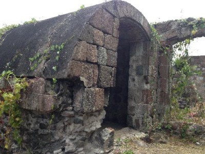
Monday, April 14, 2014 This morning we motored an hour from St. Kitts over to the neighboring island of Nevis and picked up a mooring just off the Four Seasons resort. We picked up Edgar and Hella in our dink and went to the town dock for check-in. As we were walking up the dock, an older gentleman named Sydney asked if we'd like to hire him for a taxi tour, and we agreed. The price was as follows: $75 for me: everyone else free. So he drove us all around this beautiful small island, recounting some of its history and showing some of the many old sugar and cotton plantations. Like other islands in this part of the Leewards, this island is an extinct volcano with enough sloping benches to afford agriculture. He told us that before slavery was abolished in by the British 1834 there were 165 plantations. We stopped at a couple of old sugar cane mills and were impressed by the huge, heavy gears that drove the crushers and all the associated machinery for making steam to drive the steam engine powering the crushers. Some of the old cane mills have been converted to hotels or other tourist attractions. This island is also the birthplace of Alexander Hamilton. I just finished a biography of this man who was a right hand of George Washington during the American Revolutionary War and during Washington's presidency.
St. Bart's to St. Kitts
27 April 2014 | 17 15'N:062 39.6'E, Island of St. Christopher
Jack
Sunday, April 13, 2014
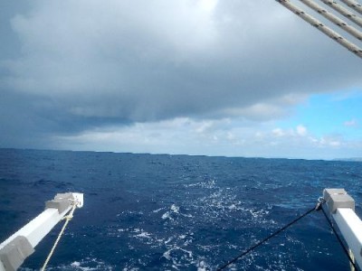
Up at 5am for early breakfast. Forecast winds look good for passage to Montserrat Island, but the day dawned with lots of clouds and gusty winds into the anchorage. We decided to go for it, so after breakfast we dropped our mooring and headed out by 6:30. Sailing down the west coast of St. Bart's we had quite gusty winds, which is to be expected sailing on the lee side of the island. As we cleared the south end of the island, the wind settled to a steady 20 knots on the beam, and the seas were running 4 to 6 feet. The wind angle was great for our course, until about 10 am, when the rain squalls all around began bending the tradewind more to the southeast, turning it into a headwind. The squalls also increased the wind velocity into the middle 20's, so we headed up and put a reef in the main. At the same time, we took about 45 minutes to replace a block (pulley) on the mainsheet that was plainly failing. While we changed that, we looked up to see a waterspout (funnel cloud tha t touches the water) dropping out of a rainsquall about 4 miles away, so we were anxious to finish up the repair and get back underway.
Eventually, the squalls bent the wind so far south that we gave it up and changed course to cross the north end of St. Kitt's. With the wind on the beam and a reef in main and jib we were surfing down the crests at over 12 knots, making 8 knots up the backs of the waves. It was an exhilirating ride that lasted about three hours, until we turned the corner to sail down the west side of the island. Then the wind got so shifty that we dropped the sails and motored the last 8 miles to the check-in anchorage at Basseterre, St. Kitts. The waves were rolling in there, so we dinghied in, did the check-in, then rehoisted the dink and headed down island to White House Bay, which was calm and secluded. We shared the anchorage with our friends on Edgar and Hella on Lucky Palima and two other boats. St. Kitts and Nevis are English speaking islands. St Barts, St Martin, Guadeloupe: French.
St. Barthelemy
27 April 2014 | 17 55.5'N:062 52.2'E, Island of St. Barthelemy
Sherri
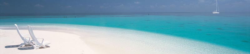
We sailed to the French island of St Bart's, Columbier Bay on Thursday, 4/9. The wind was pretty much on our nose at about 20K so that was not very comfortable, but in 4 hours we were anchored in this lovely bay on the NW shore. There are about 20 boats in here this morning, after the morning exodus, and by this evening there will probably be 30 or so, most of them charter boats. We are very protected here with high hills all around that are covered in cactus, low trees and a few palms. At the head of the bay is the best beach we've seen since we left the Bahamas, and parts of it are staked out for camping spots. We wake up to kid goats calling for their mamas and their bells tinkling on the craggy hillside. The Tropic birds on the bluffs are spectacular, swooping and sailing in groups of 4 or 5. We watched a Frigate bird chase one of the Tropics and nearly caught him. After that the Tropics dispersed. We're guessing the Tropic birds are nesting, but we haven't seen that yet .
Friday we walked about 5K to the town of Gustavia with our German friends Edgar and Hella. The 1st kilometer was over a mountain trail to a small village, as there are no roads to this anchorage. The rest of the walk was on narrow, extremely steep and windy roads. I was surprised at how tall the hills are here. I couldn't stop taking pictures because everywhere was another scenic view looking down on waves crashing, various shades of blue ocean, clean and orderly towns with closely packed colorful houses and shops and beautiful flowering gardens.
We were standing at an intersection on a ridge saddle, looking down at Gustavia on one side and the airport on the other as a twin engine otter buzzed us so closely that Hella dropped to the ground on it's literal dive for the airport. The strip has waves lapping at it on the far end and a bluff with the traffic circle on it on the approach. From our vantage point looking nearly vertically down at the runway we couldn't see the numbers on the approach end. The trade winds are such that the approaching airplanes cross the ridge top roadway at less that 50' height and then dive for the strip. Your dad says the approaching aircraft likely can't see any part of the strip until they cross the ridge! It looks like the strip might be about 3,000' long.
The water is warm, the sun is shining. We have everything we need. Can't ask for more!
On Saturday, April 12, we were joined by Edgar and Hella for a dive at Petit Jean, just off the SW tip of the bay we're anchored in. The corals were pretty good there, not the best we've seen. We did watch a grouper catch a smaller fish, and Jack swam into a shallow cave that had 25 or 30 same-size tarpon, all about 4' length. They weren't the least bothered by his presence, even when he reached out and touched one with his hand. We mostly swam at depths from 30 to 50 feet, because that's where the colors were best seen with the light filtering effect of the water.
Across the Anegada Passage
07 April 2014 | 18 03'N:063 05.9'E, Island of St. Martin
Jack
April 3, 2014 Across the Anegada Passage to St. Martin 18d, 03m N, 63d, 05.9 W
Up at 5am in April 2, we had breakfast, Sherri made sandwiches and got snacks handy for the all-day crossing. We got the boat ready for going to sea with all hatches secured and all the loose bits inside stowed in their proper places. By first light at 6am we were already in the channel for the exit to round the top of Virgin Gorda, just inside Necker Island, Sir Richard Branson's private Caribbean island. We stopped briefly before the narrow part of the channel to let a megayacht pass, giving him priority for the deepest course. The brilliant sunrise revealed a relatively calm sea, which stayed that way for the 80 nautical mile, 12 hour crossing. We experienced two heavy rain squalls as we approached St. Martin, but wind stayed well below 20 knots all day, and the highest seas may have been 6' at about 9 seconds; a very easy ride.
The sun had just set when we rounded the corner into Simpson Bay, St. Martin, and it was completely dark by the time we crossed the bay and got the hook down between the beach and a bunch of megayachts anchored in deeper water toward the center of the bay.
In the morning, we took the 9:30 am bridge opening on the Dutch side of the island, from Simpson Bay on the outside, into Simpson Lagoon. We had to wait a few minutes for a second bridge opening of the new bridge across the lagoon to the Princess Juliana Airport, so we could anchor on the French side of the lagoon. On the French side there is no charge for anchoring and the check in is only US $7.25, or 5 Euros. If you check in on the Dutch side they nick you $40 for each bridge opening and $40/week to anchor. The second part isn't so bad, but those bridge openings can add up by the time you pass both ways.
Anchor down, boat secured, we dinghied over to the town of Marigot on the French side and found the tiny customs office on the dock. They direct you upstairs to a garret with three computers, and you check yourself in. Of course, you have to interpret the French instructions, but it's not a great burden. Back downstairs you pay the fee, get a receipt and stroll around the dockside and back into the town to choose from the many elegant French restaurants. Toby was happy to be ashore again, and we enjoyed window shopping the high-end jewelry and clothing stores. We decided we could pass on the $200 shirts and $180 pants displayed. None of the many diamond shops had prices displayed in the windows. I guess if you have to ask.....
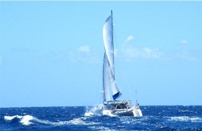
| Vessel Name: | Taiga |
| Vessel Make/Model: | Catana 44 |
| Hailing Port: | Eagle River, Alaska |
| Crew: | Jack and Sherri Hayden |
| About: | Taiga is a 1997 Catana 44 catamaran. We bought her in November, 2010 in Hampton, Virginia. This is our second sailboat and we love it. It is fast and comfortable. |
Gallery not available
Crew of Taiga
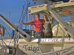
Who: Jack and Sherri Hayden
Port: Eagle River, Alaska