
Tai Mo Shan
05 December 2022 | Tasman Sea
06 January 2021 | Moreton Bay, Australia
23 October 2020 | Brisbane, Australia
15 October 2020 | Gladstone, Australia
12 October 2020 | Mackay, Australia
07 October 2020 | Mackay, Australia
03 October 2020 | Townsville Australia
25 September 2020 | Magnetic Island, Australia
20 September 2020 | Hinchinbrook Island, Australia
12 September 2020 | Great Palm Island, Australia
12 September 2020 | Horseshoe Bay, Magnetic Island, Australia
06 September 2020 | Townsville, Australia
18 August 2020 | Townsville, Australia
12 August 2020 | Hook Reef, Australia
10 August 2020 | Hook Island, Australia
10 August 2020 | South Molle Island, Australia
06 August 2020 | Airlie Beach, Australia
06 August 2020 | Cid Harbour, Whitsunday Group, Australia
29 July 2020 | Shaw Island, Australia
29 July 2020 | Goldsmith Island, Australia
Brisbane - well Moreton Bay and bits
12 January 2015
18 December 2014 to 7 January 7 2015
Well, quite a gap to fill!
Social. We spent Christmas Day at our Nephew, Matt’s family. He and his wife Debs were great hosts to us and Debs parents. And of course the three children were great, showing what Christmas is about. Plan A was to drive there and then return the same day. Plan B was soon in force as we celebrated Christmas properly and stayed the night!
New Year’s Eve looked a little lack luster, with no fireworks at Manly. We thought about sailing up the Brisbane River to anchor and watch the fireworks planned for the CBD. These are traditionally excellent, with some 80,000 crowding the river side to watch. Unfortunately we were late planning, so could not get an overnight mooring (indeed, we cannot see where to book river moorings at all!), and did not really fancy anchoring in the river (the risk of fouling the anchor on stuff in the riverbed is too high). So, being us, we put the word out that we would be having a few drinks under the big tree at the marina entrance. A dozen or so other people turned up and we saw the New Year in properly.
Sailing. Yes, we have got out sailing in Moreton Bay a couple of times! Initially we headed out to ‘Sand Hills’ for a few days. Sand Hills are just that, some sizeable sand dunes 30m or so high on Moreton Island. There are two patches, Big Sand Hills are some 50m high and extend half way across the island, whilst Little Sand Hills are a bit lower, but spread almost across the island, some 2km. For the first trip we concentrated on Little Sand Hills, climbing them about 1/3 of the way in to get the view (and some exercise). The anchorage is well sheltered from the prevailing Easterly winds by Moreton Island. However, the coastline there is shallow which means anchoring in 5 metres of so of water nearly 1km from the high water mark. Of course, the tide then retreats and leaves 500m or so of mud and sand flats to explore. Sea birds abound but what got our attention were the soldier crabs. These are only small, about the size of a large marble. But they exist in numbers, thousands of them, if not hundreds of thousands of them. Fortunately they are too small to pinch and, unusually for Australian natives, are not poisonous or really cause any harm. This is just as well as they act in concert. The crabs swarm together and run away in a group. They collect and move in a carpet of crabs with only the stragglers rapidly burying themselves in the sand and mud. It is really quite a sight, with the gentle rustling sound of thousands of little legs to accompany it.
Beachcombing, we also came across a Morton Bay Bug, or Slipper Lobster. This was covered in sand and lying motionless. Initially we thought it was dead and it was only when Helen touched it with her shoe that it came to life, rapidly backed off and buried itself. Now Lobster is good, even great, food, so Paul was there digging after it. Suffice to say the lobster easily won the race, no feed there!
Our second trip out was a bit more extensive. First stop was Saint Helena Island. The anchorage was a bit open with some motion in the water. The bottom also only has a slight slope. So we had to anchor shallow (one metre or so under the keel at low tide) but still some way off. More importantly the bottom had odd ‘lumps’ on it, meaning a couple of anchoring attempts to ensure we had good clearance under the keel. Still we did get ashore, noting the small coral heads on the way in; our strange ‘lumps’ had been identified. The island used to be a penal colony and many of the old buildings still remain as ruins. Unfortunately most of the island, including almost all the ruins, can only be accessed as part of a prearranged guided tour. Still we were able to wander around and see such sights as the old jetty and shark proof swimming pool for the warders. Apparently one of them died in the pool, not from shark attack, although we did suspect perhaps a prisoner attack? The island is a reserve and the natives are in force. The wallabies were a bit shy, but the mosquitoes were not. We beat a hasty retreat and could only sympathise with those early inhabitants who could not!
Next stop was Sand Hills again, after a fruitless stop at a fishing hole Paul had identified from the Internet. The hole was indeed about the deepest part of Moreton Bay, at over 27m, but the fish still ignored it! And Little Sand Hills, well the challenge was to get to the ocean on the other side of the island. It is only a couple of km direct. However, the bush has no paths through it and being lowland bush is pretty dense. That just left going over the sand hills; easy! 4 ridges, a bit of scrub and there you are. Well the first attempt saw us over the first 2 ridges using a meandering course to avoid the steep parts. But that was that as the 3rd ridge was simply too steep and high for Helen. Still there was a challenge, unmet. So the next day Paul set out. The subtle use of weaving tracks had failed so in typical style Paul just hit it head on, storming up the steep slopes with great strides (that rapidly got shorter!). Still 4 ridges conquered and some scrub cut through and Paul stood on the ocean shore. And what a shore! The white sand beach, edged by brown green bush stretched into the distance North and South. The blue sea turned into white surf that pounded the beach and formed a mist that gently faded out the distant beach. There was a single set of quad bike tracks on the beach, gradually disappearing as the waves lapped over them. And no one else, no vehicle or boat as far at the eye could see. The only sound was the surf rhythmically hitting the sand. This was well worth bursting lungs scrambling over shifting sand!
Next stop was Peel Island. We went in to the anchorage on the Western side to shelter from the Easterly winds. Another shallow anchorage some way out, albeit with what appeared to be a uniform bottom. The tide was out so the shoreline was unpleasant mud over coral rock with exposed sea grass beds. Still worth a (quick) look. Back on board and the anchorage was proving to have a lot of motion as the tide swept past the island and the wind appeared to flow around it. This was not going to be good overnight, so we decided to push onto Deanbilla Bay near Dunwich on North Stradbroke Island. This involves taking a narrow channel between an island and a shoal. It is marked by a yellow post and we have seen ferries take the route before; indeed we left Deanbilla this way on our first trip. Still the leap through was interesting, not through the depth as the tide ensured we had plenty of clearance. No, it was the ferry behind and one in front who also wanted to go close to the yellow post. No problems just a bit of a squeeze! Deanbilla is also interesting. It is shallow (it seems all anchorages in Moreton Bay are!), and the tidal flow is enough to push the boat and overcome the wind so instead of ending up anchored facing into wind, one can have the wind from any direction over the boat. Ah well, a good muddy bottom means the anchor holds really effectively.
The weather the next day consisted of a series of short, heavy showers. Still we watched the sky and got ashore in the dingy dry. We had looked around Dunwich before, but after 4pm on a Friday, and the place was tightly closed up for the night. This time we were in the morning and the small town was open and welcoming. The museum was a highlight. It had a limited number of exhibits but told the story of Dunwich and indeed North Stradbroke Island really well. The place has always been a bit different from aboriginal beginnings through a penal colony, ship pilot station, quarantine post and benevolent asylum for the ‘inebriate and elderly’, to its present day sand extraction and tourism. Of course, the record of shipwrecks on the treacherous passage also held some fascination. A quick look at the ‘Little Ship Club’, an outstation of the Royal Queensland Yacht Squadron, fish and chips in town, fresh meat from the butcher and that was Dunwich. Possibly the best part was a good run back, Yankee poled out in 20 knot winds, an easy 6 knots through flat water; nice!
Car trip to Gold Coast. We had been thinking of sailing down the inland waterways to the Gold Coast for some time. However, these waterways are narrow, and shallow; we would be at the mercy of the tide in a few places. In addition we were not sure what there would be for us at the Gold Coast. It is renowned for its tourist hotels and fine beaches, but the inland side seemed to consist of several developments of houses with boat parking attached. Suitable anchorages looked few and far between, and we suspect, full of moorings. In the end we decided to drive the hour or so to the Gold Coast to have a look.
The trip down was easy on good roads and motorways. Once at the Gold Coast we headed for Seaway Tower, if only because this had an exit to the ocean and we often heard the Volunteer Marine Rescue on the radio. Indeed, they were probably the clearest station! So off the motorway, along a few hotels, over a bridge (far too low for a yacht, and we watched a large launch inch underneath, with an inch or so to spare!), past the Waterworld theme park with its big rollercoaster rides and bigger car park, along the end of the sand spit to the Gold Coast Seaway. This is a 300m wide channel some 1km or so long between the sandy South Stradbroke Island and the Mainland sand spit. It is lined with man-made large erosion protection boulders to avoid the tide from the inland waters up to the Southern end of Moreton Bay scouring the sand away. We thought the tide against the ocean swell would make the seaway ‘interesting’. We were there at a mid ebb tide with one to two metre swell and watched a catamaran negotiate the seaway quite happily. No problems there. However, looking inland we could see few anchorages, and those we could see were very tight with many boats at anchor or moored. We then drove south along the length of the Gold Coast. It does indeed have an excellent beach, which produces some nice surf (Surfers’ Paradise on one of the beaches!). There is good beach access and regular lifeguard areas. The area close to the beach is a green strip of parks with good, mostly free, parking. Of course this makes it a major tourist destination, and there are very, very many large high rise hotels, and lots more lower rise apartment and hotel blocks as well. We followed the beach for 20km or so to Point Danger. This is famous as it marks the boundary between Queensland and New South Road (driving to the Point on the North side of Boundary Road one is in Queensland, driving back on the South side one is in New South Wales!), and because Captain Cook noted the landmark on his voyages. In fact he named the point because it, and the danger reefs, arose out of the sea but were partly obscured by mist. Still the aptly named Mount Warning inland to the South was visible!
So our conclusions of the Gold Coast; if we visited we would drive down and retain the flexibility of the car.
On the way back we detoured to Jacobs Well, a narrow turn on the inland waterway. It was as charted, narrow and shallow. Still it was a nice drive through the sugar cane fields. In addition there was a tackle shop there. We had not caught any fish since arriving in Moreton Bay and so sought advice. The shopkeeper, and several of his customers, were great and a good discussion ensured. In brief, we were still using the hooks that worked in New Zealand; size 5 or 6 to get good snapper and such like. Moreton Bay had the occasional (very occasional) snapper, but mostly much smaller fish. A good target species is Whiting (good eating!), using size 1 or 2 hooks! The other secret of Moreton Bay is the crabs. The use of crab pots is common, and for good reason; the crabs are plentiful and taste good. We did a good deal on four crab pots, and some small lures and hooks. Will they work, well that is for later blogs!
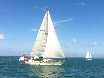
And the photo. Well we were sailing and saw another boat a little way ahead going in our direction. Now to the landlubbers the definition of a yacht race is two or more boats going in the same direction! We duly managed to pass them, after some interesting wind shifts. A little later we got an e-mail from ‘Genesis’, with the superb photo attached. So many thanks Fred and Marie; even if the photo shows we needed a bit more Main Halyard tension!
Well, quite a gap to fill!
Social. We spent Christmas Day at our Nephew, Matt’s family. He and his wife Debs were great hosts to us and Debs parents. And of course the three children were great, showing what Christmas is about. Plan A was to drive there and then return the same day. Plan B was soon in force as we celebrated Christmas properly and stayed the night!
New Year’s Eve looked a little lack luster, with no fireworks at Manly. We thought about sailing up the Brisbane River to anchor and watch the fireworks planned for the CBD. These are traditionally excellent, with some 80,000 crowding the river side to watch. Unfortunately we were late planning, so could not get an overnight mooring (indeed, we cannot see where to book river moorings at all!), and did not really fancy anchoring in the river (the risk of fouling the anchor on stuff in the riverbed is too high). So, being us, we put the word out that we would be having a few drinks under the big tree at the marina entrance. A dozen or so other people turned up and we saw the New Year in properly.
Sailing. Yes, we have got out sailing in Moreton Bay a couple of times! Initially we headed out to ‘Sand Hills’ for a few days. Sand Hills are just that, some sizeable sand dunes 30m or so high on Moreton Island. There are two patches, Big Sand Hills are some 50m high and extend half way across the island, whilst Little Sand Hills are a bit lower, but spread almost across the island, some 2km. For the first trip we concentrated on Little Sand Hills, climbing them about 1/3 of the way in to get the view (and some exercise). The anchorage is well sheltered from the prevailing Easterly winds by Moreton Island. However, the coastline there is shallow which means anchoring in 5 metres of so of water nearly 1km from the high water mark. Of course, the tide then retreats and leaves 500m or so of mud and sand flats to explore. Sea birds abound but what got our attention were the soldier crabs. These are only small, about the size of a large marble. But they exist in numbers, thousands of them, if not hundreds of thousands of them. Fortunately they are too small to pinch and, unusually for Australian natives, are not poisonous or really cause any harm. This is just as well as they act in concert. The crabs swarm together and run away in a group. They collect and move in a carpet of crabs with only the stragglers rapidly burying themselves in the sand and mud. It is really quite a sight, with the gentle rustling sound of thousands of little legs to accompany it.
Beachcombing, we also came across a Morton Bay Bug, or Slipper Lobster. This was covered in sand and lying motionless. Initially we thought it was dead and it was only when Helen touched it with her shoe that it came to life, rapidly backed off and buried itself. Now Lobster is good, even great, food, so Paul was there digging after it. Suffice to say the lobster easily won the race, no feed there!
Our second trip out was a bit more extensive. First stop was Saint Helena Island. The anchorage was a bit open with some motion in the water. The bottom also only has a slight slope. So we had to anchor shallow (one metre or so under the keel at low tide) but still some way off. More importantly the bottom had odd ‘lumps’ on it, meaning a couple of anchoring attempts to ensure we had good clearance under the keel. Still we did get ashore, noting the small coral heads on the way in; our strange ‘lumps’ had been identified. The island used to be a penal colony and many of the old buildings still remain as ruins. Unfortunately most of the island, including almost all the ruins, can only be accessed as part of a prearranged guided tour. Still we were able to wander around and see such sights as the old jetty and shark proof swimming pool for the warders. Apparently one of them died in the pool, not from shark attack, although we did suspect perhaps a prisoner attack? The island is a reserve and the natives are in force. The wallabies were a bit shy, but the mosquitoes were not. We beat a hasty retreat and could only sympathise with those early inhabitants who could not!
Next stop was Sand Hills again, after a fruitless stop at a fishing hole Paul had identified from the Internet. The hole was indeed about the deepest part of Moreton Bay, at over 27m, but the fish still ignored it! And Little Sand Hills, well the challenge was to get to the ocean on the other side of the island. It is only a couple of km direct. However, the bush has no paths through it and being lowland bush is pretty dense. That just left going over the sand hills; easy! 4 ridges, a bit of scrub and there you are. Well the first attempt saw us over the first 2 ridges using a meandering course to avoid the steep parts. But that was that as the 3rd ridge was simply too steep and high for Helen. Still there was a challenge, unmet. So the next day Paul set out. The subtle use of weaving tracks had failed so in typical style Paul just hit it head on, storming up the steep slopes with great strides (that rapidly got shorter!). Still 4 ridges conquered and some scrub cut through and Paul stood on the ocean shore. And what a shore! The white sand beach, edged by brown green bush stretched into the distance North and South. The blue sea turned into white surf that pounded the beach and formed a mist that gently faded out the distant beach. There was a single set of quad bike tracks on the beach, gradually disappearing as the waves lapped over them. And no one else, no vehicle or boat as far at the eye could see. The only sound was the surf rhythmically hitting the sand. This was well worth bursting lungs scrambling over shifting sand!
Next stop was Peel Island. We went in to the anchorage on the Western side to shelter from the Easterly winds. Another shallow anchorage some way out, albeit with what appeared to be a uniform bottom. The tide was out so the shoreline was unpleasant mud over coral rock with exposed sea grass beds. Still worth a (quick) look. Back on board and the anchorage was proving to have a lot of motion as the tide swept past the island and the wind appeared to flow around it. This was not going to be good overnight, so we decided to push onto Deanbilla Bay near Dunwich on North Stradbroke Island. This involves taking a narrow channel between an island and a shoal. It is marked by a yellow post and we have seen ferries take the route before; indeed we left Deanbilla this way on our first trip. Still the leap through was interesting, not through the depth as the tide ensured we had plenty of clearance. No, it was the ferry behind and one in front who also wanted to go close to the yellow post. No problems just a bit of a squeeze! Deanbilla is also interesting. It is shallow (it seems all anchorages in Moreton Bay are!), and the tidal flow is enough to push the boat and overcome the wind so instead of ending up anchored facing into wind, one can have the wind from any direction over the boat. Ah well, a good muddy bottom means the anchor holds really effectively.
The weather the next day consisted of a series of short, heavy showers. Still we watched the sky and got ashore in the dingy dry. We had looked around Dunwich before, but after 4pm on a Friday, and the place was tightly closed up for the night. This time we were in the morning and the small town was open and welcoming. The museum was a highlight. It had a limited number of exhibits but told the story of Dunwich and indeed North Stradbroke Island really well. The place has always been a bit different from aboriginal beginnings through a penal colony, ship pilot station, quarantine post and benevolent asylum for the ‘inebriate and elderly’, to its present day sand extraction and tourism. Of course, the record of shipwrecks on the treacherous passage also held some fascination. A quick look at the ‘Little Ship Club’, an outstation of the Royal Queensland Yacht Squadron, fish and chips in town, fresh meat from the butcher and that was Dunwich. Possibly the best part was a good run back, Yankee poled out in 20 knot winds, an easy 6 knots through flat water; nice!
Car trip to Gold Coast. We had been thinking of sailing down the inland waterways to the Gold Coast for some time. However, these waterways are narrow, and shallow; we would be at the mercy of the tide in a few places. In addition we were not sure what there would be for us at the Gold Coast. It is renowned for its tourist hotels and fine beaches, but the inland side seemed to consist of several developments of houses with boat parking attached. Suitable anchorages looked few and far between, and we suspect, full of moorings. In the end we decided to drive the hour or so to the Gold Coast to have a look.
The trip down was easy on good roads and motorways. Once at the Gold Coast we headed for Seaway Tower, if only because this had an exit to the ocean and we often heard the Volunteer Marine Rescue on the radio. Indeed, they were probably the clearest station! So off the motorway, along a few hotels, over a bridge (far too low for a yacht, and we watched a large launch inch underneath, with an inch or so to spare!), past the Waterworld theme park with its big rollercoaster rides and bigger car park, along the end of the sand spit to the Gold Coast Seaway. This is a 300m wide channel some 1km or so long between the sandy South Stradbroke Island and the Mainland sand spit. It is lined with man-made large erosion protection boulders to avoid the tide from the inland waters up to the Southern end of Moreton Bay scouring the sand away. We thought the tide against the ocean swell would make the seaway ‘interesting’. We were there at a mid ebb tide with one to two metre swell and watched a catamaran negotiate the seaway quite happily. No problems there. However, looking inland we could see few anchorages, and those we could see were very tight with many boats at anchor or moored. We then drove south along the length of the Gold Coast. It does indeed have an excellent beach, which produces some nice surf (Surfers’ Paradise on one of the beaches!). There is good beach access and regular lifeguard areas. The area close to the beach is a green strip of parks with good, mostly free, parking. Of course this makes it a major tourist destination, and there are very, very many large high rise hotels, and lots more lower rise apartment and hotel blocks as well. We followed the beach for 20km or so to Point Danger. This is famous as it marks the boundary between Queensland and New South Road (driving to the Point on the North side of Boundary Road one is in Queensland, driving back on the South side one is in New South Wales!), and because Captain Cook noted the landmark on his voyages. In fact he named the point because it, and the danger reefs, arose out of the sea but were partly obscured by mist. Still the aptly named Mount Warning inland to the South was visible!
So our conclusions of the Gold Coast; if we visited we would drive down and retain the flexibility of the car.
On the way back we detoured to Jacobs Well, a narrow turn on the inland waterway. It was as charted, narrow and shallow. Still it was a nice drive through the sugar cane fields. In addition there was a tackle shop there. We had not caught any fish since arriving in Moreton Bay and so sought advice. The shopkeeper, and several of his customers, were great and a good discussion ensured. In brief, we were still using the hooks that worked in New Zealand; size 5 or 6 to get good snapper and such like. Moreton Bay had the occasional (very occasional) snapper, but mostly much smaller fish. A good target species is Whiting (good eating!), using size 1 or 2 hooks! The other secret of Moreton Bay is the crabs. The use of crab pots is common, and for good reason; the crabs are plentiful and taste good. We did a good deal on four crab pots, and some small lures and hooks. Will they work, well that is for later blogs!
And the photo. Well we were sailing and saw another boat a little way ahead going in our direction. Now to the landlubbers the definition of a yacht race is two or more boats going in the same direction! We duly managed to pass them, after some interesting wind shifts. A little later we got an e-mail from ‘Genesis’, with the superb photo attached. So many thanks Fred and Marie; even if the photo shows we needed a bit more Main Halyard tension!
Comments
| Vessel Name: | Tai Mo Shan |
| Vessel Make/Model: | North Cape 43 (Ed Brewer) |
| Hailing Port: | Auckland, NZ |
| Crew: | Paul and Helen Dickinson |
| About: | |
| Extra: | Tai Mo Shan was built in Hong Kong in 1980 by Emsworth Ltd of Athang Hau. Her name translates to 'Big Hat Mountain' which overlooks the boat yard. We prefer 'Tai Mo Shan'; something is lost in translation. Tai Mo Shan has a proud tradition of cruising the Pacific, and we intend to continue that. |
Gallery not available
Who: Paul and Helen Dickinson
Port: Auckland, NZ