
Tai Mo Shan
05 December 2022 | Tasman Sea
06 January 2021 | Moreton Bay, Australia
23 October 2020 | Brisbane, Australia
15 October 2020 | Gladstone, Australia
12 October 2020 | Mackay, Australia
07 October 2020 | Mackay, Australia
03 October 2020 | Townsville Australia
25 September 2020 | Magnetic Island, Australia
20 September 2020 | Hinchinbrook Island, Australia
12 September 2020 | Great Palm Island, Australia
12 September 2020 | Horseshoe Bay, Magnetic Island, Australia
06 September 2020 | Townsville, Australia
18 August 2020 | Townsville, Australia
12 August 2020 | Hook Reef, Australia
10 August 2020 | Hook Island, Australia
10 August 2020 | South Molle Island, Australia
06 August 2020 | Airlie Beach, Australia
06 August 2020 | Cid Harbour, Whitsunday Group, Australia
29 July 2020 | Shaw Island, Australia
29 July 2020 | Goldsmith Island, Australia
Passage to Wallis
21 September 2014
17 to 19 Sep 14
Passage to Wallis
Early on we got the boat ready for the passage. As usual there were a myriad of small jobs to do; securing everything, getting the dingy on deck and such like. Paul then went off to Customs who, opening at just after 0900, duly stamped and sealed our paperwork. Back on board, a quick goodbye to our friends in the other boats and we cast off. Maneuvering out of the Marina was easy (that is why we went for a slot near the end) and we were soon motoring out past the reefs to sea.
It was an easy sail with SE to E wind; we had just the foresail up on a broad reach. There was a slight roll due to the sea but that was OK, and we made steady if not fast progress. Past Savaii the wind dropped so we slowed but still had progress. Then we had a fish strike our trolling line. The line fairly screamed off the reel. It was even taking line at full clutch and Paul had to apply pressure with his thumb as well to stop the line streaming away (indeed he had to use the string holding the reel to the boat between the reel and his thumb to reduce the friction). Eventually the line slowed and then Paul was able to slowly reel it in. Nevertheless, the fish kept on breaking away and taking line. It even jumped clear out of the water a few times. A hard 30 minute fight then followed. Eventually with the fish only some 30m from the boat, the weight disappeared and it escaped. Paul hauled the line in; the fish had bent the hook! This was 6/0 so not a small hook by any means. It just goes to show how it hard fought. We are not sure of the type of fish but suspect a Sailfish as it appeared blue when it jumped.
The wind dropped at night off Savaii, so we put the motor on and motor sailed in what is best described as a sloppy sea. There was quite a bit of movement which did not help setting the sail. We ended up with the sail poled out but reefed to a tight sail. Still progress kept up with the motor.
The autopilot then kept having ‘rudd drv’ error. Our rudder drive was failing so it was not the autopilot box itself. We did try to reset but to no avail. There was not a lot we could do at sea to fix it so we hand steered to a compass bearing. This was tiring as each person on watch has to be actively steering. The sloppy sea did not help as well. Still, onwards.
The next day wind increased so we could knock off the motor at about midday. Tai Mo Shan moves better under sail only so that was a partial relief. But it was still hand steering.
Day broke on the 3rd day, with Wallis some 30 miles off. It is charted as 114m high, so we should see it. However, some clouds on the horizon confused things, was it land or cloud. We got closer, 20 miles and we could still not be sure. Then, at 17 miles, yes, no doubt those dark grey lumps are land and not cloud. Land ahoy! And we were on track.
Some 10 miles out, Paul was on the wheel and got a shock. A small whale surfaced some 30m to our starboard side. Now, small is relative; this one was about the size of Tai Mo Shan. We are not sure of the type, possibly a Pilot Whale. Still it was dark grey with a blunt head. And it did not breach and blow off vapour as many whales do. Nor did it show its tail as it submerged. Instead it just surfaced, cruised by and dived again. It, or another one, then reappeared about 100m behind us. Time to start the motor and hope the vibration would let the whales know we were not another whale, and so keep clear. It seemed to work.
Wallis Island is surrounded by a reef with only on entry suitable for yachts and indeed any boat bigger than a small fishing dingy. The island is run by the French and, apparently, they are very good at maintaining their navigation marks. The chart shows the channel through the reef has a sight line (a white painted rock lines up with a white triangle on a grey wall on the hill some mile or so away). The chart also shows many posts and marks guiding the way not only through the fringing reef but also past the many smaller reefs, shoals and rocks to the anchoring area just off Matu Utu, the main town. The chart usefully gives compass headings between the main marks. All good, if the chart is accurate and the navigation marks maintained. Ah, yes, the cruising guide also warns that the GPS coordinates are slightly out; visual navigation is the order of the day again.
A few miles off the reef entrance we called up Wallis Island Customs, Port Control and well anyone on the VHF radio channel 16. No official answer, but a yacht anchored at Wallis Island did answer in broken English. The yacht, Maui, said that Wallis Island did not respond to the radio; ah well. However, the navigation marks were good and as charted, a huge relief. The sailing guide does warn of strong currents, up to 6 knots with the consequent turbulence) coming out of the reef (the swell breaking over the reef constantly fills the lagoon). We checked tide times and confirmed that we were approaching one of the two advisable ‘windows’ (i.e. 30 mins to 2 hours before high water and 15 to 45 mins after low water).
We dropped sails and lined up on the gap in the reef. We could see the breaking sea on the reef and the gap with no white water. Then we could see the white rock (with a white post next to it). Then the red and green poles became visible. Helen on the wheel and Paul outside calling out the headings Tai Mo Shan motored in at a steady 5 knots over the ground. We never spotted the white mark on the grey wall, but the posts and the clarity of the water saw us safely in. There is then a 7nm route inside the lagoon consisting of some 6 dog legs. Again Helen steered whilst Paul checked the chart, spotted posts and called the course. The water in the lagoon was wonderfully clear and it was easy to spot the channel. Still we got to our anchoring area with some caution. The chart indicated an anchoring area a little way off the wharf at Mata Utu. However, the bottom was not that flat. Again, caution applied we anchored a way offshore in a reasonably flat part some 8 to 10m under the keel.
The stats: 285 nm over the ground in 2 days, 6 hours and 10 minutes, giving an average speed of 5.3 knots. Steady if unexciting.
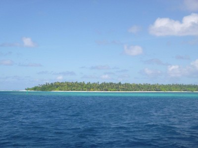
The photo: one of the outlying islands, note the colour of the water and the green navigation post.
Passage to Wallis
Early on we got the boat ready for the passage. As usual there were a myriad of small jobs to do; securing everything, getting the dingy on deck and such like. Paul then went off to Customs who, opening at just after 0900, duly stamped and sealed our paperwork. Back on board, a quick goodbye to our friends in the other boats and we cast off. Maneuvering out of the Marina was easy (that is why we went for a slot near the end) and we were soon motoring out past the reefs to sea.
It was an easy sail with SE to E wind; we had just the foresail up on a broad reach. There was a slight roll due to the sea but that was OK, and we made steady if not fast progress. Past Savaii the wind dropped so we slowed but still had progress. Then we had a fish strike our trolling line. The line fairly screamed off the reel. It was even taking line at full clutch and Paul had to apply pressure with his thumb as well to stop the line streaming away (indeed he had to use the string holding the reel to the boat between the reel and his thumb to reduce the friction). Eventually the line slowed and then Paul was able to slowly reel it in. Nevertheless, the fish kept on breaking away and taking line. It even jumped clear out of the water a few times. A hard 30 minute fight then followed. Eventually with the fish only some 30m from the boat, the weight disappeared and it escaped. Paul hauled the line in; the fish had bent the hook! This was 6/0 so not a small hook by any means. It just goes to show how it hard fought. We are not sure of the type of fish but suspect a Sailfish as it appeared blue when it jumped.
The wind dropped at night off Savaii, so we put the motor on and motor sailed in what is best described as a sloppy sea. There was quite a bit of movement which did not help setting the sail. We ended up with the sail poled out but reefed to a tight sail. Still progress kept up with the motor.
The autopilot then kept having ‘rudd drv’ error. Our rudder drive was failing so it was not the autopilot box itself. We did try to reset but to no avail. There was not a lot we could do at sea to fix it so we hand steered to a compass bearing. This was tiring as each person on watch has to be actively steering. The sloppy sea did not help as well. Still, onwards.
The next day wind increased so we could knock off the motor at about midday. Tai Mo Shan moves better under sail only so that was a partial relief. But it was still hand steering.
Day broke on the 3rd day, with Wallis some 30 miles off. It is charted as 114m high, so we should see it. However, some clouds on the horizon confused things, was it land or cloud. We got closer, 20 miles and we could still not be sure. Then, at 17 miles, yes, no doubt those dark grey lumps are land and not cloud. Land ahoy! And we were on track.
Some 10 miles out, Paul was on the wheel and got a shock. A small whale surfaced some 30m to our starboard side. Now, small is relative; this one was about the size of Tai Mo Shan. We are not sure of the type, possibly a Pilot Whale. Still it was dark grey with a blunt head. And it did not breach and blow off vapour as many whales do. Nor did it show its tail as it submerged. Instead it just surfaced, cruised by and dived again. It, or another one, then reappeared about 100m behind us. Time to start the motor and hope the vibration would let the whales know we were not another whale, and so keep clear. It seemed to work.
Wallis Island is surrounded by a reef with only on entry suitable for yachts and indeed any boat bigger than a small fishing dingy. The island is run by the French and, apparently, they are very good at maintaining their navigation marks. The chart shows the channel through the reef has a sight line (a white painted rock lines up with a white triangle on a grey wall on the hill some mile or so away). The chart also shows many posts and marks guiding the way not only through the fringing reef but also past the many smaller reefs, shoals and rocks to the anchoring area just off Matu Utu, the main town. The chart usefully gives compass headings between the main marks. All good, if the chart is accurate and the navigation marks maintained. Ah, yes, the cruising guide also warns that the GPS coordinates are slightly out; visual navigation is the order of the day again.
A few miles off the reef entrance we called up Wallis Island Customs, Port Control and well anyone on the VHF radio channel 16. No official answer, but a yacht anchored at Wallis Island did answer in broken English. The yacht, Maui, said that Wallis Island did not respond to the radio; ah well. However, the navigation marks were good and as charted, a huge relief. The sailing guide does warn of strong currents, up to 6 knots with the consequent turbulence) coming out of the reef (the swell breaking over the reef constantly fills the lagoon). We checked tide times and confirmed that we were approaching one of the two advisable ‘windows’ (i.e. 30 mins to 2 hours before high water and 15 to 45 mins after low water).
We dropped sails and lined up on the gap in the reef. We could see the breaking sea on the reef and the gap with no white water. Then we could see the white rock (with a white post next to it). Then the red and green poles became visible. Helen on the wheel and Paul outside calling out the headings Tai Mo Shan motored in at a steady 5 knots over the ground. We never spotted the white mark on the grey wall, but the posts and the clarity of the water saw us safely in. There is then a 7nm route inside the lagoon consisting of some 6 dog legs. Again Helen steered whilst Paul checked the chart, spotted posts and called the course. The water in the lagoon was wonderfully clear and it was easy to spot the channel. Still we got to our anchoring area with some caution. The chart indicated an anchoring area a little way off the wharf at Mata Utu. However, the bottom was not that flat. Again, caution applied we anchored a way offshore in a reasonably flat part some 8 to 10m under the keel.
The stats: 285 nm over the ground in 2 days, 6 hours and 10 minutes, giving an average speed of 5.3 knots. Steady if unexciting.
The photo: one of the outlying islands, note the colour of the water and the green navigation post.
Comments
| Vessel Name: | Tai Mo Shan |
| Vessel Make/Model: | North Cape 43 (Ed Brewer) |
| Hailing Port: | Auckland, NZ |
| Crew: | Paul and Helen Dickinson |
| About: | |
| Extra: | Tai Mo Shan was built in Hong Kong in 1980 by Emsworth Ltd of Athang Hau. Her name translates to 'Big Hat Mountain' which overlooks the boat yard. We prefer 'Tai Mo Shan'; something is lost in translation. Tai Mo Shan has a proud tradition of cruising the Pacific, and we intend to continue that. |
Gallery not available
Who: Paul and Helen Dickinson
Port: Auckland, NZ