
Tai Mo Shan
05 December 2022 | Tasman Sea
06 January 2021 | Moreton Bay, Australia
23 October 2020 | Brisbane, Australia
15 October 2020 | Gladstone, Australia
12 October 2020 | Mackay, Australia
07 October 2020 | Mackay, Australia
03 October 2020 | Townsville Australia
25 September 2020 | Magnetic Island, Australia
20 September 2020 | Hinchinbrook Island, Australia
12 September 2020 | Great Palm Island, Australia
12 September 2020 | Horseshoe Bay, Magnetic Island, Australia
06 September 2020 | Townsville, Australia
18 August 2020 | Townsville, Australia
12 August 2020 | Hook Reef, Australia
10 August 2020 | Hook Island, Australia
10 August 2020 | South Molle Island, Australia
06 August 2020 | Airlie Beach, Australia
06 August 2020 | Cid Harbour, Whitsunday Group, Australia
29 July 2020 | Shaw Island, Australia
29 July 2020 | Goldsmith Island, Australia
Passage Suva to Brisbane
26 November 2014
9 to 23 Nov 14
Passage Suva to Brisbane
The forecast was for light Westerly winds for first couple of days then back to trade winds. That would OK, we can sail into light winds fine, and then trade winds to push us to Australia. So off we went a nice bright Sunday, light winds. Through the reef passage; it is easy, honest. It has poles, leading lights (blue), sight boards, big boats, ships do it. We have done it have the GPS trace. Still we don’t like doing it! But we got safely through with no dramas, and are glad to be clear of reef passes for a few months.
Then sails up and tacking into a headwind, pretty much as forecast. But not a light wind, this was moderate to strong, 20 knots or so! Well, we put it down to the Kandavu Passage. Kandavu is the large Island to the South of where we were and it is a known phenomenon that the wind is squeezed between this and the main island of Viti Levu. As a result the wind increases in strength. Ah well, we spent the day tacking past Kandavu. The passage is some 20 miles or so wide so we could keep clear of the fringing reefs. We made steady, slow progress and darkness saw us just clearing Kandavu. However as we entered the ocean, the wind did not abate, indeed, if anything it increased to 25, gusting 30 knots. The next day saw us pushing hard in to this strong wind and rough sea. As the day progressed things got worse, more wind and higher seas. We had not been able to sleep properly with the significant movement on the boat throughout the passage so far. Still we had pushed on and whilst steering off target (we wanted to go WSW, the wind was pretty much WSW, and we could not sail directly into wind), we were now in open ocean with some searoom. Come nightfall we made the decision to hove to.
Hoving to is the maneuver where we tack (turn the bow through the wind) without changing the sails. As a result the sails work against each other and the boat sits pretty much across the wind, drifting slowly down and across the wind. The advantage is that the motion on the boat is dramatically reduced, the disadvantage is that we would be drifting at 1.5 knots away from Australia. Still, we lit up the exterior of the boat and set the radar guard (it would bleep if it detected ships, or indeed anything, within 10 miles), and went to sleep.
Come the morning the wind had dropped slightly and, refreshed after a reasonable sleep, we continued on, sailing close to our intended course. We were keeping a radio sked with Ed on AKA and Jim as ‘Rag of the Air’ based in Fiji. They were able to update the weather forecast for us. In addition we were getting ‘GRIB’ files from the HF Sailmail, which showed us forecast wind strength and direction for our area of the ocean. These forecasts all showed the wind from the SW, dropping and then becoming light.
Amazingly the forecasts were right for once. As the 11th progressed the wind swung around slightly and we could sail to our intended course. In fact, the wind strength was such that we could sail at a respectable 6 knots or so, in the direction we wanted; great!
And the forecasts were right on the wind drop to light winds. Our great progress slowed through the 12th until mid afternoon our speed dropped below 3 knots and we were forced to turn the motor on and motor sail.
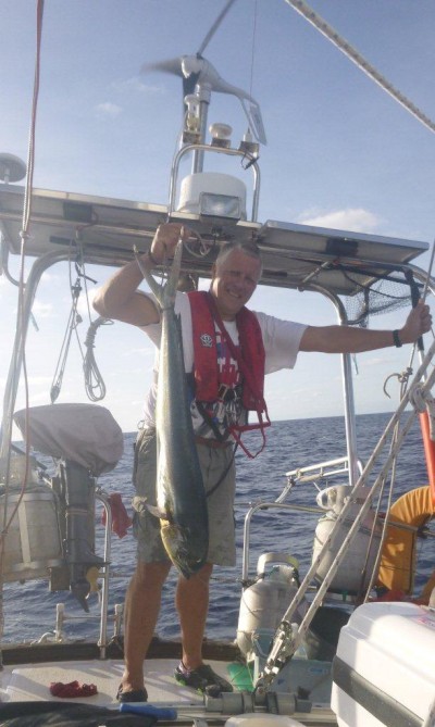
And from a sailing point of view that was it until the 19 Nov. Light to no wind, motoring or motor sailing. We did sail where we could when a gentle breeze set in, but rarely exceeded 4 knots. In fact, after a day or so of motoring at a respectable 5 knots we had to reduce speed significantly to conserve fuel; we still had a long way to go! Of course, the lack of wind did have a bright side as the sea state dropped. We even managed to raise the Genneker for 6 hours (and pushed along at 5 to 6 knots!) one day. We also set our fishing lines. We had moved away from rods, and now had hand lines tied out the back. These lines were light rope with a steel trace and trolling lure. The weak link was the 80lb trace; we reckoned if a fish broke that we did not want it near the boat! The advantage of the hand lines is that we did not need to react immediately to a fish strike, the fish would just be towed along behind us until we could haul it in. Of course a rod and reel allows the line to be taken out; more fun but less practical. On 13 Nov we hit a shoal of Mahi Mahi. We did not land the first as the hook pulled out as we got him close the boat. We got the second on board but it fought well, and a metre or so of mad muscular fish really moves! As a result it flipped itself up and over the side back into the water! And the third; well no chances here. First we gaffed him through the guts, got him aboard, and then gaffed him through the head as he thrashed around. A loop around the tail to calm the death throes, and we had dinner, and a couple of other meals!
On the 15th we spotted land! This was Ile Walpole, some 90 miles to the East of New Caledonia. It has very little information on the chart, just an outline and half a dozen soundings. The Pacific Anchorage guide, has an entry, noting a reported anchorage in some 40m (yes forty metres) of water, which slopes steeply to shore. In short, not a good place to stay! We saw it from some 10 miles or so. A low grey brown flat topped island. It looked like sheer cliffs with no features like houses or trees to be seen. No wonder it was not well charted.
Our HF reception had not been brilliant. Apparently we were coming out loud and clear, but incoming signals were weak. After much fault finding we put this down to interference from our on board systems. Basically the radio has an automatic gain control which ensures signals do not overload the system. The problem is that interference is a signal, and this can cause the radio to wind down the gain so that other incoming signals are lost. Eventually we had a practically electrically dead ship as we steadily turned off all our systems. The freezer, wind generator, freshwater system, fridge, instruments, and computer (and we suspect autopilot) all caused a degree of interference! Still at least then we could hear and communicate! Life is a compromise.
So, the 19th Nov and we are saving fuel by keeping the engine revs low (1000 rpm) and motor sailing at just about 4 knots. The sea is sapphire blue, reflecting the blue sky, and flat calm. The forecast is for the wind to swing back to light trade winds (i.e. South East to East) late afternoon, and there on the horizon the darker blue of a wind line. And in it, yes, the occasional white flecks of breaking crests – wind! Half an hour later and we are sailing. OK, only 4 knots, but motor off and sailing. And so the wind built and swung so come the 20th we were sailing a run (wind behind us) at 6 knots. It wasn’t all easy as there was quite a bit of roll that upset the sails, still a bit of judicious trimming and we could keep going making some 5 to 6 knots, and directly where we wanted to go.
Early on 22nd and we now had too much wind! We were reefing and reducing sail but still powering along at 7 to 8 knots. 0330 and we saw a ship which passed us some 2 miles off. By late afternoon the wind had steadily increased to the extent that we put away the Main Sail and were sailing on a reefed Yankee (foresail) only. And still we were travelling at a steady 7 knots in a rough sea. We were only 20 or so miles from land but a slight haze hid it from view. We spotted another ship, and perhaps smelled, well dust, on the air? Or were we imagining it?
Later on, 1900, and 3 ships, big ships at that, all missing us, but we must be close now! Then there, on the horizon, a blue smudge, 10 miles off and land ahoy!
We were still sailing fast, some 7 knots or so. Just as well as the entrance to Moreton Bay is some 40 miles from the entrance to the Brisbane River, and the marina is some 10 miles up the river; a way to go yet. Still, this was Australia and the charts were accurate, the GPS spot on, and the shipping lane well marked. Onwards!
First the clear water mark near the entrance to Moreton Bay. This is charted as a lit buoy. In reality it is a tower some 2 metres diameter and 10m high. Easy to see, and definitely something to miss! A little later we saw the mark showing the edge of the shoals in Moreton Bay entrance. We went round that in to the shipping channel. Of course, the mark is not a buoy, but instead a substantial post (to be fair probably just less than one metre diameter) some 5 metres high. Good to see, better to miss! It seems to be the Aussie way; why use a buoy or other minor mark when a big concrete post will do?
Darkness fell and we stormed down the channel a strong wind pushing us along at over 7 knots. Into the complex part of Moreton Bay. The channels are well marked, but at night the marks become a profusion of flashing lights. Red and Green for channel markers and white for ‘cardinal marks’ along with the odd yellow ‘other’ marker. Situation awareness becomes a problem especially as lights do not give a good indication of distance away. Still the GPS and chartplotter is clear and accurate, and frequent trips to look at the chart plotter and then outside the boat worked well.
We had the VHF tuned to channel 16 (general and distress) and channel 12 (port control). We could hear them talking to the cruise ship Pacific Princess and a cargo ship. And there they were ahead of us, all lit up. Were they going into the shipping channel we were using, if so could we avoid them or would we have to leave the channel? They were anchored; phew! We were now in a channel only 2 miles from the Pacific Princess doing 7 knots straight at her. Then one mile (thank goodness she was not a US warship!), then half a mile, and, our turn point; we turn away and get a good view of her lit up in her glory, immense screen at top playing some film or other!
As we approached the river entrance the wind was strong and gusty, the sea very choppy and rough, and the autopilot could not hold course. It had done extremely well until now, but the conditions were not too friendly so fair enough. It was time to hand steer and call Brisbane Port Control (called Brisbane VTS – Very Tired Secretaries?). We asked permission to enter the river, a slight delay, then permission granted but the cruise ship Pacific Dawn was coming out, and a couple of other ships as well, so we had to stay to the right (starboard) side of the channel. OK.
The channel starts with a long cutting through shoals well marked by lights either side. Yes, the lights are high up on big concrete posts, and flash red or green as appropriate.
We entered the channel staying right of centre. Soon the Pacific Dawn called us and asked us to go further to the right. Now cruise ships are well it from the side and rear; Christmas Trees are plain compared to them. However, from the front they are just a black shape. And we could just about make out the huge black shape coming past the dockland lights. We moved to the right staying as close to the posts as we dared in the rough sea. Of course the fact that the posts were only really visible when the lights flashed every couple of second just added to the fun!
Still we got a good view of the Pacific Dawn as she passed us a good 20m away. The radio call of ‘Thank You Tai Mo Shan’ was appreciated. Even better, the Pacific Dawn then called up the next ship saying that they had passed us, we were motoring sensibly, staying to the right of the channel and there was plenty of room; no problems!
We motored on through the cutting to the dockland. Fortunately this opens out a bit, so we passed the bulk carrier easily. Then on, beyond that the river itself. This has leading lights to guide us, as well as channel markers, and cardinal marks (to show hazards). Of course, these lights are against a background of darkness, and lots of lights from industrial areas. Ah, the chartplotter, a life saver! Paul was up and down constantly, whilst Helen had the helm, following Paul’s directions.
Into the river, which is pretty big. Ships use it and we passed several at the variety of wharves along the way; petroleum, grain, cement to list a few. Still it is a bit disconcerting as one passes the darker patches and cannot see the river bank, or even the river!
On 5 miles and we can see the Brisbane Bridge. Now Auckland Harbour Bridge has lights on it, primarily for the traffic. It is visible but somewhat subdued, perhaps even mellow; typical Kiwi. And the Brisbane Bridge; well it has bright green neon lights along its outside length, lighting the sky and proclaiming that here it is. Not subtle, mellow or gentle, just well, Aussie!
The customs wharf is at the end of E Arm, Rivergate Marina. This is, according to our guides, close to the bridge.
OK, a mile off, and we cannot see any lights or really anything stating ‘Marina’. Half a mile, and nope. 200m and there, a boat or two parked up. We head towards them. Out with the spot light and yes, boats and a post with ‘A Arm’ on it. Along a bit, count the piers, and there is E Arm. There is a big motor boat (well small ship!) either on the end of the arm of the next arm. We decide to go in front of it. There is a strong wind behind us, but an ebbing tide flowing out of the river. The tide wins out and we continue heading up river as we line up on the pier. Then there we are, alongside, lines tied up and 0345 (Fiji Time), 0045 (Australian Eastern Daylight Time) 23 Nov 14, we have arrived!
And the stats. A planned route of 1553 nm, we actually sailed 1643 nm. Time taken 13 days, 18 hours and 45 minutes giving an average speed of 4.97 knots; those last few days really increased the average!
The photo: dinner.
Passage Suva to Brisbane
The forecast was for light Westerly winds for first couple of days then back to trade winds. That would OK, we can sail into light winds fine, and then trade winds to push us to Australia. So off we went a nice bright Sunday, light winds. Through the reef passage; it is easy, honest. It has poles, leading lights (blue), sight boards, big boats, ships do it. We have done it have the GPS trace. Still we don’t like doing it! But we got safely through with no dramas, and are glad to be clear of reef passes for a few months.
Then sails up and tacking into a headwind, pretty much as forecast. But not a light wind, this was moderate to strong, 20 knots or so! Well, we put it down to the Kandavu Passage. Kandavu is the large Island to the South of where we were and it is a known phenomenon that the wind is squeezed between this and the main island of Viti Levu. As a result the wind increases in strength. Ah well, we spent the day tacking past Kandavu. The passage is some 20 miles or so wide so we could keep clear of the fringing reefs. We made steady, slow progress and darkness saw us just clearing Kandavu. However as we entered the ocean, the wind did not abate, indeed, if anything it increased to 25, gusting 30 knots. The next day saw us pushing hard in to this strong wind and rough sea. As the day progressed things got worse, more wind and higher seas. We had not been able to sleep properly with the significant movement on the boat throughout the passage so far. Still we had pushed on and whilst steering off target (we wanted to go WSW, the wind was pretty much WSW, and we could not sail directly into wind), we were now in open ocean with some searoom. Come nightfall we made the decision to hove to.
Hoving to is the maneuver where we tack (turn the bow through the wind) without changing the sails. As a result the sails work against each other and the boat sits pretty much across the wind, drifting slowly down and across the wind. The advantage is that the motion on the boat is dramatically reduced, the disadvantage is that we would be drifting at 1.5 knots away from Australia. Still, we lit up the exterior of the boat and set the radar guard (it would bleep if it detected ships, or indeed anything, within 10 miles), and went to sleep.
Come the morning the wind had dropped slightly and, refreshed after a reasonable sleep, we continued on, sailing close to our intended course. We were keeping a radio sked with Ed on AKA and Jim as ‘Rag of the Air’ based in Fiji. They were able to update the weather forecast for us. In addition we were getting ‘GRIB’ files from the HF Sailmail, which showed us forecast wind strength and direction for our area of the ocean. These forecasts all showed the wind from the SW, dropping and then becoming light.
Amazingly the forecasts were right for once. As the 11th progressed the wind swung around slightly and we could sail to our intended course. In fact, the wind strength was such that we could sail at a respectable 6 knots or so, in the direction we wanted; great!
And the forecasts were right on the wind drop to light winds. Our great progress slowed through the 12th until mid afternoon our speed dropped below 3 knots and we were forced to turn the motor on and motor sail.
And from a sailing point of view that was it until the 19 Nov. Light to no wind, motoring or motor sailing. We did sail where we could when a gentle breeze set in, but rarely exceeded 4 knots. In fact, after a day or so of motoring at a respectable 5 knots we had to reduce speed significantly to conserve fuel; we still had a long way to go! Of course, the lack of wind did have a bright side as the sea state dropped. We even managed to raise the Genneker for 6 hours (and pushed along at 5 to 6 knots!) one day. We also set our fishing lines. We had moved away from rods, and now had hand lines tied out the back. These lines were light rope with a steel trace and trolling lure. The weak link was the 80lb trace; we reckoned if a fish broke that we did not want it near the boat! The advantage of the hand lines is that we did not need to react immediately to a fish strike, the fish would just be towed along behind us until we could haul it in. Of course a rod and reel allows the line to be taken out; more fun but less practical. On 13 Nov we hit a shoal of Mahi Mahi. We did not land the first as the hook pulled out as we got him close the boat. We got the second on board but it fought well, and a metre or so of mad muscular fish really moves! As a result it flipped itself up and over the side back into the water! And the third; well no chances here. First we gaffed him through the guts, got him aboard, and then gaffed him through the head as he thrashed around. A loop around the tail to calm the death throes, and we had dinner, and a couple of other meals!
On the 15th we spotted land! This was Ile Walpole, some 90 miles to the East of New Caledonia. It has very little information on the chart, just an outline and half a dozen soundings. The Pacific Anchorage guide, has an entry, noting a reported anchorage in some 40m (yes forty metres) of water, which slopes steeply to shore. In short, not a good place to stay! We saw it from some 10 miles or so. A low grey brown flat topped island. It looked like sheer cliffs with no features like houses or trees to be seen. No wonder it was not well charted.
Our HF reception had not been brilliant. Apparently we were coming out loud and clear, but incoming signals were weak. After much fault finding we put this down to interference from our on board systems. Basically the radio has an automatic gain control which ensures signals do not overload the system. The problem is that interference is a signal, and this can cause the radio to wind down the gain so that other incoming signals are lost. Eventually we had a practically electrically dead ship as we steadily turned off all our systems. The freezer, wind generator, freshwater system, fridge, instruments, and computer (and we suspect autopilot) all caused a degree of interference! Still at least then we could hear and communicate! Life is a compromise.
So, the 19th Nov and we are saving fuel by keeping the engine revs low (1000 rpm) and motor sailing at just about 4 knots. The sea is sapphire blue, reflecting the blue sky, and flat calm. The forecast is for the wind to swing back to light trade winds (i.e. South East to East) late afternoon, and there on the horizon the darker blue of a wind line. And in it, yes, the occasional white flecks of breaking crests – wind! Half an hour later and we are sailing. OK, only 4 knots, but motor off and sailing. And so the wind built and swung so come the 20th we were sailing a run (wind behind us) at 6 knots. It wasn’t all easy as there was quite a bit of roll that upset the sails, still a bit of judicious trimming and we could keep going making some 5 to 6 knots, and directly where we wanted to go.
Early on 22nd and we now had too much wind! We were reefing and reducing sail but still powering along at 7 to 8 knots. 0330 and we saw a ship which passed us some 2 miles off. By late afternoon the wind had steadily increased to the extent that we put away the Main Sail and were sailing on a reefed Yankee (foresail) only. And still we were travelling at a steady 7 knots in a rough sea. We were only 20 or so miles from land but a slight haze hid it from view. We spotted another ship, and perhaps smelled, well dust, on the air? Or were we imagining it?
Later on, 1900, and 3 ships, big ships at that, all missing us, but we must be close now! Then there, on the horizon, a blue smudge, 10 miles off and land ahoy!
We were still sailing fast, some 7 knots or so. Just as well as the entrance to Moreton Bay is some 40 miles from the entrance to the Brisbane River, and the marina is some 10 miles up the river; a way to go yet. Still, this was Australia and the charts were accurate, the GPS spot on, and the shipping lane well marked. Onwards!
First the clear water mark near the entrance to Moreton Bay. This is charted as a lit buoy. In reality it is a tower some 2 metres diameter and 10m high. Easy to see, and definitely something to miss! A little later we saw the mark showing the edge of the shoals in Moreton Bay entrance. We went round that in to the shipping channel. Of course, the mark is not a buoy, but instead a substantial post (to be fair probably just less than one metre diameter) some 5 metres high. Good to see, better to miss! It seems to be the Aussie way; why use a buoy or other minor mark when a big concrete post will do?
Darkness fell and we stormed down the channel a strong wind pushing us along at over 7 knots. Into the complex part of Moreton Bay. The channels are well marked, but at night the marks become a profusion of flashing lights. Red and Green for channel markers and white for ‘cardinal marks’ along with the odd yellow ‘other’ marker. Situation awareness becomes a problem especially as lights do not give a good indication of distance away. Still the GPS and chartplotter is clear and accurate, and frequent trips to look at the chart plotter and then outside the boat worked well.
We had the VHF tuned to channel 16 (general and distress) and channel 12 (port control). We could hear them talking to the cruise ship Pacific Princess and a cargo ship. And there they were ahead of us, all lit up. Were they going into the shipping channel we were using, if so could we avoid them or would we have to leave the channel? They were anchored; phew! We were now in a channel only 2 miles from the Pacific Princess doing 7 knots straight at her. Then one mile (thank goodness she was not a US warship!), then half a mile, and, our turn point; we turn away and get a good view of her lit up in her glory, immense screen at top playing some film or other!
As we approached the river entrance the wind was strong and gusty, the sea very choppy and rough, and the autopilot could not hold course. It had done extremely well until now, but the conditions were not too friendly so fair enough. It was time to hand steer and call Brisbane Port Control (called Brisbane VTS – Very Tired Secretaries?). We asked permission to enter the river, a slight delay, then permission granted but the cruise ship Pacific Dawn was coming out, and a couple of other ships as well, so we had to stay to the right (starboard) side of the channel. OK.
The channel starts with a long cutting through shoals well marked by lights either side. Yes, the lights are high up on big concrete posts, and flash red or green as appropriate.
We entered the channel staying right of centre. Soon the Pacific Dawn called us and asked us to go further to the right. Now cruise ships are well it from the side and rear; Christmas Trees are plain compared to them. However, from the front they are just a black shape. And we could just about make out the huge black shape coming past the dockland lights. We moved to the right staying as close to the posts as we dared in the rough sea. Of course the fact that the posts were only really visible when the lights flashed every couple of second just added to the fun!
Still we got a good view of the Pacific Dawn as she passed us a good 20m away. The radio call of ‘Thank You Tai Mo Shan’ was appreciated. Even better, the Pacific Dawn then called up the next ship saying that they had passed us, we were motoring sensibly, staying to the right of the channel and there was plenty of room; no problems!
We motored on through the cutting to the dockland. Fortunately this opens out a bit, so we passed the bulk carrier easily. Then on, beyond that the river itself. This has leading lights to guide us, as well as channel markers, and cardinal marks (to show hazards). Of course, these lights are against a background of darkness, and lots of lights from industrial areas. Ah, the chartplotter, a life saver! Paul was up and down constantly, whilst Helen had the helm, following Paul’s directions.
Into the river, which is pretty big. Ships use it and we passed several at the variety of wharves along the way; petroleum, grain, cement to list a few. Still it is a bit disconcerting as one passes the darker patches and cannot see the river bank, or even the river!
On 5 miles and we can see the Brisbane Bridge. Now Auckland Harbour Bridge has lights on it, primarily for the traffic. It is visible but somewhat subdued, perhaps even mellow; typical Kiwi. And the Brisbane Bridge; well it has bright green neon lights along its outside length, lighting the sky and proclaiming that here it is. Not subtle, mellow or gentle, just well, Aussie!
The customs wharf is at the end of E Arm, Rivergate Marina. This is, according to our guides, close to the bridge.
OK, a mile off, and we cannot see any lights or really anything stating ‘Marina’. Half a mile, and nope. 200m and there, a boat or two parked up. We head towards them. Out with the spot light and yes, boats and a post with ‘A Arm’ on it. Along a bit, count the piers, and there is E Arm. There is a big motor boat (well small ship!) either on the end of the arm of the next arm. We decide to go in front of it. There is a strong wind behind us, but an ebbing tide flowing out of the river. The tide wins out and we continue heading up river as we line up on the pier. Then there we are, alongside, lines tied up and 0345 (Fiji Time), 0045 (Australian Eastern Daylight Time) 23 Nov 14, we have arrived!
And the stats. A planned route of 1553 nm, we actually sailed 1643 nm. Time taken 13 days, 18 hours and 45 minutes giving an average speed of 4.97 knots; those last few days really increased the average!
The photo: dinner.
Comments
| Vessel Name: | Tai Mo Shan |
| Vessel Make/Model: | North Cape 43 (Ed Brewer) |
| Hailing Port: | Auckland, NZ |
| Crew: | Paul and Helen Dickinson |
| About: | |
| Extra: | Tai Mo Shan was built in Hong Kong in 1980 by Emsworth Ltd of Athang Hau. Her name translates to 'Big Hat Mountain' which overlooks the boat yard. We prefer 'Tai Mo Shan'; something is lost in translation. Tai Mo Shan has a proud tradition of cruising the Pacific, and we intend to continue that. |
Gallery not available
Who: Paul and Helen Dickinson
Port: Auckland, NZ