Joy of Cruising

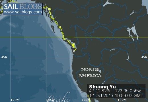
17 October 2017 | Boat position at Shelton: 47°12.82’N; 123°05.01’W
16 October 2017 | Boat position at Shilshole Marina: 47°40.65’N; 122°24.59’W
15 October 2017 | Boat position at Friday Harbor: 48°32.20’N; 123°0.59’W
27 September 2017 | Boat position on Granville Island: 49°16.35’N; 123°08.24’W
26 September 2017 | Boat position on Granville Island: 49°16.35’N; 123°08.24’W
22 July 2017 | Boat position at Granville Island: 49°16.35’N; 123°08.24’W
21 July 2017 | Boat position at Vancouver Rowing Club, Canada: 49°17.77’N; 123°07.85’W
20 July 2017 | Boat position at the Vancouver Rowing Club, Canada: 49°17.77’N; 123°07.85’W
19 July 2017 | Boat position at the Vancouver Rowing Club: 49°17.77’N; 123°07.85’W
18 July 2017 | Boat position in Active Pass: 48°51.64’N; 123°18.54’W
17 July 2017 | Boat position at Otter Cove, Pender Island, Canada: 48°47.84’N; 123°18.51’W
15 July 2017 | Boat position at Port Bedwell, Pender Island, Canada: 48 44.97'N; 123 13.97'W
14 July 2017 | Boat position at RVYC: 48 27.19'N; 123 17.73'W
13 July 2017 | Boat position at RVYC: 48 27.19'N; 123 17.73'W
12 July 2017 | Boat position at SNSYC: 48 40.44'N; 123 25.02'W
12 July 2017 | Boat position at SNSYC: 48 40.44'N; 123 25.02'W
11 July 2017 | Boat position at SNSYC: 48 40.44'N; 123 25.02'W
10 July 2017 | Boat position at Ganges: 48 51.00'N; 123 29.53'W
09 July 2017 | Boat position at Ganges: 48 51.00'N; 123 29.53'W
08 July 2017 | Boat position at Montague Harbour: 48 53.63'N; 123 24.03'W
Khutze Inlet to Shearwater
16 June 2017 | Boat position at Shearwater: 52 08.85'N; 128 05.21'W
Pam Lau and Ted Berry
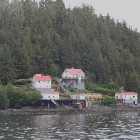
Picture: The lighthouse and all the buildings at Boat Bluff, Sarah Passage. It's hard to see the actual light but I believe its on the tower on the right.
Noon to noon miles: 71 Miles since Mexico: 25,682
Weather: Cloudy in the morning but clear and sunny in the afternoon and evening. Wind: SE winds. Boat speed: 3 - 5 knots with a head wind of 4 to 20 knots. We motored the whole way most times with mainsail.
Khutze Inlet was a magnificent sanctuary for us for two and a half days. It was so protected that we were not sure if there was a storm out there or not. Before dawn on 16th June at 04:45 we moved out to the main channel only to meet the same strong headwind (about 20 knots) as we had experienced two days earlier when we came in. "What happened to the forecast? Was it a deception all along?" we wondered. The day will be long, so I took first turn to sleep. Poor Ted, he was left alone in the dark and cold cockpit with the wind and currents pushing us back and the cold rain driving against us. When I got up with hot coffee and a snack of smoked salmon, alfalfa spouts and rye crackers, everything seemed to be fine again. The song "Ain't No Sunshine When She's Gone" came to mind because Ted said that all the time I was asleep in my nice warm bed, weather conditions were depressing. But, not long after I got up, we emerged from the narrow, dark, channel surrounded by high mountains, into a wider channel and sunshine.
Gradually the weather improved and we were able to make some progress even though the wind and currents were against us. It is a mystery to me that we can motor/sail the entire day and the currents were always against us. Don't the tides go in and out twice each day? In spite of the adversities, at least we were moving forward. The mountain scenery on both sides of the channel was magnificent. There were various shapes, heights and shades of mountains, covered mostly with dark green conifer trees and occasionally, weaved in with them, patches of lime green colored bushes, many of which looked like roads. It's as if nature is in the process of reclaiming old logging roads.
When I was on watch, we came to an area that showed signs of civilization. "Shuang Yu" passed a small hydro-electric plant in the middle of the wilderness with a dam above and waterfall below. From there I could see a road leading to a native village call Klemtu a couple of miles south of the dam. Around the corner there was one of the most elaborate lighthouses that we have ever seen. It was the famous Boat Bluff lighthouse at Sarah Passage. There were at least four or five buildings all painted creamy white with red roofs. It was quite a contrast to see something so European in the wilderness. The sun came out at that time as if to highlight the complex of buildings.
After passing the lighthouse we entered Finlayson Channel and then in a few miles we came to the open waters of Milbanke Sound. The weather forecast had predicted high winds but we were lucky this time, the wind was with us and the warm sun and the lighter wind made it a pleasant sail. As we entered Seaforth Channel, heading towards Shearwater, scores of fishing boats were heading in the opposite direction; out to the Sound. It reminded me of one evening when we came out of Pankor Island in Malaysia; the sea was filled with fishing boats.
Bella Bella, a native community, appeared two nautical miles before Shearwater Marine Resort. Arriving at the resort, there was one long pontoon, packed with motor and sailing yachts and no room left for us. While we were circling around looking for space, a fishing boat moved forward so that we could dock behind him. After settling in, the harbor master arrived and told us to move because five fishing boats were coming in. He said we could raft up to another sailboat. Just as we were following his instructions, a boat moved out and we were able to have a slip for the night. It was a 16-hour day but we made good progress. Even though we were exhausted we felt satisfied.
Comments
| Vessel Name: | Shuang Yu |
| Vessel Make/Model: | Catalina 400 |
| Hailing Port: | San Diego |
| Crew: | Ted Berry and Pam Lau |
| Home Page: | www.sailblogs.com/member/tedandpam/ |
| Social: |
|
Shuang Yu's Photos - Main
 |
These pictures were taken from my two favorite events in Ensenada: the "Women Spanish Class" and the "Knitters and the Dabbers"
11 Photos
Created 9 February 2011
|
 |
Van, Cida, Ted and Pam went to the Catalina Islands from 12/10 to 12/17/2010.
No Photos
Created 14 January 2011
|
Who: Ted Berry and Pam Lau
Port: San Diego