Joy of Cruising

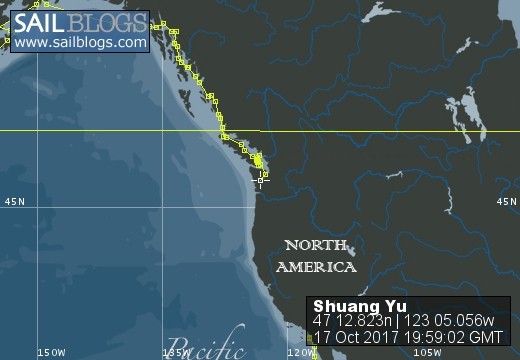
17 October 2017 | Boat position at Shelton: 47°12.82’N; 123°05.01’W
16 October 2017 | Boat position at Shilshole Marina: 47°40.65’N; 122°24.59’W
15 October 2017 | Boat position at Friday Harbor: 48°32.20’N; 123°0.59’W
27 September 2017 | Boat position on Granville Island: 49°16.35’N; 123°08.24’W
26 September 2017 | Boat position on Granville Island: 49°16.35’N; 123°08.24’W
22 July 2017 | Boat position at Granville Island: 49°16.35’N; 123°08.24’W
21 July 2017 | Boat position at Vancouver Rowing Club, Canada: 49°17.77’N; 123°07.85’W
20 July 2017 | Boat position at the Vancouver Rowing Club, Canada: 49°17.77’N; 123°07.85’W
19 July 2017 | Boat position at the Vancouver Rowing Club: 49°17.77’N; 123°07.85’W
18 July 2017 | Boat position in Active Pass: 48°51.64’N; 123°18.54’W
17 July 2017 | Boat position at Otter Cove, Pender Island, Canada: 48°47.84’N; 123°18.51’W
15 July 2017 | Boat position at Port Bedwell, Pender Island, Canada: 48 44.97'N; 123 13.97'W
14 July 2017 | Boat position at RVYC: 48 27.19'N; 123 17.73'W
13 July 2017 | Boat position at RVYC: 48 27.19'N; 123 17.73'W
12 July 2017 | Boat position at SNSYC: 48 40.44'N; 123 25.02'W
12 July 2017 | Boat position at SNSYC: 48 40.44'N; 123 25.02'W
11 July 2017 | Boat position at SNSYC: 48 40.44'N; 123 25.02'W
10 July 2017 | Boat position at Ganges: 48 51.00'N; 123 29.53'W
09 July 2017 | Boat position at Ganges: 48 51.00'N; 123 29.53'W
08 July 2017 | Boat position at Montague Harbour: 48 53.63'N; 123 24.03'W
Banda, Indonesia 2
06 August 2012 | At noon: 04° 31.42' S; 129° 53.84'E
Pam Lau
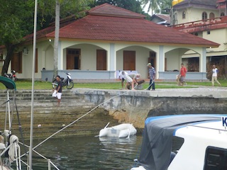
Picture:Securing the line from "Shuang Yu" to an old cannon on Banda harbor.
I met an English teacher named Miga who offered to take us on a walking tour of the island. Bargaining seems to be the culture here, so I played the game. I got a good deal for Jim and Andrea to come along and we each paid about AUS $6 (US$ 6) for Miga and his friend, John to take us around. They were with us for about four hours, so I felt somewhat guilty about paying them such small sum, so I bought a local pearl from him for $10AUS.
First he showed us a beautiful picture book giving a brief history of the island and then we started on our walking tour. There are about ten small volcanic islands in the Banda Island group. Where we are located is called Banda Neira, the capital village.
There is a wealth of historical events and legends in this place, which is fascinating and shocking. First we stopped at some aquarium concrete ponds. Our guide said once upon a time they were full of fish. Until the owner of the pond offended somebody by not paying for services rendered and the victim poisoned all the fish with casaba mixed with a toxic herb. Now there are only three baby sharks that swim lazily in one of the large rectangular ponds.
We continued to hike up the hill to the airport. The landing strip is a bit short but I don't image they have Jumbo jets up there so I'm sure the small planes wouldn't have a problem landing and taking off. It has a great view from all sides, especially the active volcano, "Mount of Fire", which is only a stones throw from the harbor. The last time it blew its top was in 1989. Hopefully it will not be "angry" while we are here.
Miga led us through a mountain path of tangled vine and brush to the Japanese cave. The entrance to the cave was camouflaged amongst the vegetation with only a slight indentation on the shady side of a hill. Jim did not go in because of his bad ankle so we plunged toward the darkness following the two locals with a flashlight. It was more of a tunnel than a cave; it was long and narrow and we had to crouch in order not to hit our head on the ceiling. I regretted going in the minute I felt the eeriness of the place. After what seemed to be a long time, (actually about 5 minutes) we came to the end. It was a bit wider than the passage. There were two holes in the ground. We were told that during World War II the Japanese used to execute people in there. They put the person horizontally with their head above one of the holes and then beheaded him. The blood ran into the hole. The idea of the tunnel was to make sure the locals did not hear the screams of the victims, so the tunnel was a series of zig-zags. How gruesome! I couldn't get out of there quickly enough. On our way out, there was another path but Miga said we couldn't go in there because it was a long ways. I immediately replied, "That is okay; we don't need to see it." I was the first one out.
We stopped at the massive Fort Belgica, which was built by the Dutch in the early 1600s to help them maintain control of the Spice Islands. At the time, they wanted a monopoly on the world supply of nutmeg, mace and cloves. There was a large open area when we first entered and off to the sides it was sectioned off into quarters. One was the jail, others were used to store the iron gallows for executions and there were others for soldiers to shoot at intruders. There were five towers to lookout in all directions. It was unbeatably secure except for the British, lead by Captain Christopher Cole and his men, who, around 1798, crept in while the Dutch were sleeping and took over the fort without a single shot being fired. The British took over the islands for seven years; it was the first even British colony. Cole's house still stands and is occupied to this very day. Then, as part of a European treaty, the British gave the islands back to the Dutch. Actually, the Dutch gave the British the Island of Manhattan in exchange for Banda. The British then changed the name of the settlement on Manhattan to New York. Before leaving Banda the British learnt how to grow and process the spices and took the seedlings and expertise to Singapore and Ceylon (Sri Lanka) to eventually break the Dutch monopoly. The Dutch were very cruel to the Banda natives. All the original natives on the island were either killed or escaped to other islands. The current population is descended from the immigrant plantation workers. Anyway, the modern Indonesians have done a tremendous amount of work in restoring the fort. Also, they planted colorful tropical plants to add more beauty to the place. It is definitely a tourist attraction.
We walked to Miga's grandfather's nutmeg orchard. Miga showed us the nutmeg trees and how they harvest and dry the nutmeg and mace. When nutmeg is ripe, it is a pale-golden color about the size of a golf ball. When it is opened, it reveals a juicy white flesh and a brown nut covered with a bright red loose growth, which is peeled off; that is mace. They soak the outside husks in saltwater overnight and then cook them into syrup or jam. I guess to get rid of the bitter taste. And then they carefully peel the mace off the nut and dry that separately. Then they dry the nutmeg. Besides the nutmeg trees, they also grow cinnamon and cloves. He said that after the cinnamon tree is three years old, they cut the tree down and then from the stump, it will grow several new cinnamon trees. He also said that they use the cinnamon wood to cook rice for special festivities, to give rice a special flavor. It was all very interesting. We must get some spice from the famous "Spice Islands".
Comments
| Vessel Name: | Shuang Yu |
| Vessel Make/Model: | Catalina 400 |
| Hailing Port: | San Diego |
| Crew: | Ted Berry and Pam Lau |
| Home Page: | www.sailblogs.com/member/tedandpam/ |
| Social: |
|
Shuang Yu's Photos - Main
 |
These pictures were taken from my two favorite events in Ensenada: the "Women Spanish Class" and the "Knitters and the Dabbers"
11 Photos
Created 9 February 2011
|
 |
Van, Cida, Ted and Pam went to the Catalina Islands from 12/10 to 12/17/2010.
No Photos
Created 14 January 2011
|
Who: Ted Berry and Pam Lau
Port: San Diego