Joy of Cruising

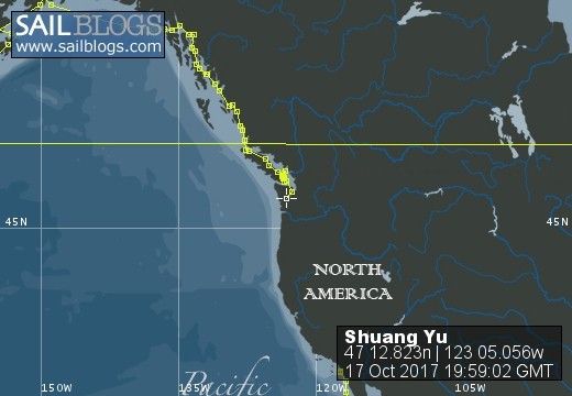
17 October 2017 | Boat position at Shelton: 47°12.82’N; 123°05.01’W
16 October 2017 | Boat position at Shilshole Marina: 47°40.65’N; 122°24.59’W
15 October 2017 | Boat position at Friday Harbor: 48°32.20’N; 123°0.59’W
27 September 2017 | Boat position on Granville Island: 49°16.35’N; 123°08.24’W
26 September 2017 | Boat position on Granville Island: 49°16.35’N; 123°08.24’W
22 July 2017 | Boat position at Granville Island: 49°16.35’N; 123°08.24’W
21 July 2017 | Boat position at Vancouver Rowing Club, Canada: 49°17.77’N; 123°07.85’W
20 July 2017 | Boat position at the Vancouver Rowing Club, Canada: 49°17.77’N; 123°07.85’W
19 July 2017 | Boat position at the Vancouver Rowing Club: 49°17.77’N; 123°07.85’W
18 July 2017 | Boat position in Active Pass: 48°51.64’N; 123°18.54’W
17 July 2017 | Boat position at Otter Cove, Pender Island, Canada: 48°47.84’N; 123°18.51’W
15 July 2017 | Boat position at Port Bedwell, Pender Island, Canada: 48 44.97'N; 123 13.97'W
14 July 2017 | Boat position at RVYC: 48 27.19'N; 123 17.73'W
13 July 2017 | Boat position at RVYC: 48 27.19'N; 123 17.73'W
12 July 2017 | Boat position at SNSYC: 48 40.44'N; 123 25.02'W
12 July 2017 | Boat position at SNSYC: 48 40.44'N; 123 25.02'W
11 July 2017 | Boat position at SNSYC: 48 40.44'N; 123 25.02'W
10 July 2017 | Boat position at Ganges: 48 51.00'N; 123 29.53'W
09 July 2017 | Boat position at Ganges: 48 51.00'N; 123 29.53'W
08 July 2017 | Boat position at Montague Harbour: 48 53.63'N; 123 24.03'W
Okinawa 1
10 June 2015 | Boat position at Ginowan Marina, Okinawa, Japan: 26 16.63'N; 127 43.70'E
Pam Lau
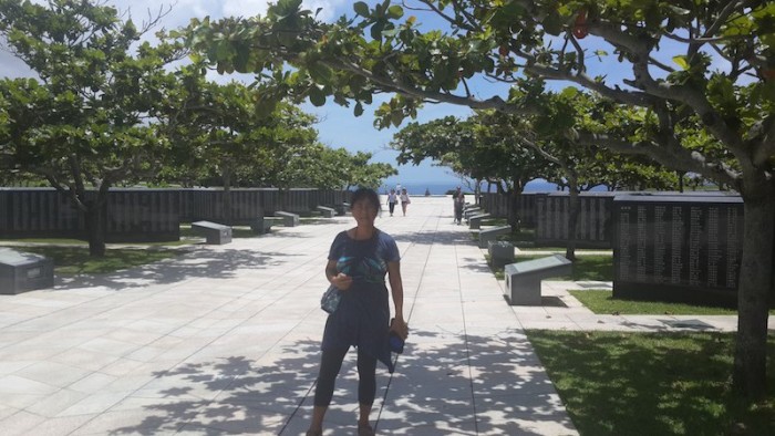
Picture: Pam at the Okinawa Peace Memorial Park
We left Ishigaki before noon. Our plan was to stop at Hirara port in the next group of islands, called Miyako Islands. The weather was foul with thunder and lighting overhead and rain later on that evening. We read in a guidebook that the island is famous for its beaches and we have seen enough beaches, especially in the South Pacific Islands, and are ready for something different. Without much debate, we continue on our way toward Ginowan Marina on Okinawa.
The wind came from behind when we first started so Ted put the spinnaker pole out to take advantage of it. No sooner had we struggled to put out the pole than the wind changed and the pole became a hindrance rather than a help. The sea was rough and the waves were pushing us constantly from side to side. Both our stomachs were knotted up like pretzels. I was nauseated all day and finally vomited toward evening. When I am seasick, the best remedy for me is to sleep. Poor Ted, he had to do most of the watches except when I came on at 02:00 in the morning. For most of the night Ted had been strategizing on how to take the spinnaker pole down so when I came on watch, immediately we had to execute his plan. It was nearly 2:00 a.m. and we were passing the island of Miyako so we had some shelter from the swell, enough for Ted take down the pole. The procedure was not painful except it was raining and dark, which made the task a bit more challenging. Nevertheless, we accomplished our task and put out the genoa once again and sailed straight to Ginowan Marina.
Okinawa is the largest island in the southern chain of islands in Japan, an historical seat of the Ryukyu dynasty. The island is special to Ted and me because we practice Shotokan karate and the founder, Funakoshi Sensei, originally came from here. After WWII, the United States had possession of the island until 1972 when it was returned to Japan with the condition that the USA has the right to use large tracts of land for military activities. Even today, there are more than 24,000 service men and women living on the island. There have been several unpleasant incidents in the past involving US personnel breaking the law, but today they are relatively low key. However, the roar of US-made fighter jets overhead is a constant reminder of their presence even though the jets appear to have no markings. We were told they belong to the Japanese military.
Ginowan Marina is located in the southern part of the island. The majority of boats in the marina are motor yachts used by local men for recreational fishing on weekends but there are a few foreign sailboats like us passing through. It is a well-run marina and reasonably priced. Its best features include a shopping mall with a large supermarket across the street and the laundry only a block away. The marina is about 15 kilometers (10 miles) from the capital of Okinawa, Naha, so we had plenty of exercise riding our bicycles to and from there.
The first time we rode to Naha we were just exploring the city with no particular purpose. First we went to Ted's favorite place, a hardware store. Then we rode to Naha harbor, which consists of warehouses and factories with semi-trailers everywhere. Ted was interested because it reminded him of his past life as a truck driver and his forever interest and academic training as an economist. I respected that because we have to examine the local economy in order to get a true picture of the place even though it was a hot day and we were touring on our bicycles. The factories were ugly and environment was dirty with many homeless people around the wharf area.
We could not rent a car because we don't have an international driver's license, another strange policy in this country. The regular bus service seemed complicated so we decided to buy a tour of historical sites to the south. Early on the morning of our tour we rode our bikes to the bus terminal in Naha. There were only two other people on the bus, both Japanese men, and the guide did not speak any English. Nevertheless, we had a great time. The tour included: the Okinawa World (limestone cave), Okinawa Peace Memorial Park, the Himeyuri Monument & Yubido Restaurant and Okinawa Outlet mall Ashibina. It was forty-two dollars per person including transportation, entrance fees and lunch.
The limestone cave was one of the best caves that we have ever seen. It is well developed and maintained. The walkway was wide, clean and safe and kept people away from the natural rock formations. The lighting in the cave accentuated its beauty and the unique features of the stalagmites and stalactites.
The next stop was definitely one of the most important sites we wanted to visit in Okinawa, the Peace Memorial Park. We strolled around the vast area, the most prominent feature of which is the Cornerstone of Peace. There are rows and rows of large grey polished marble stones with the names of people who died as a result of the Battle of Okinawa engraved on them. Japanese's names are on one side of the walkway while foreigner's names are on the other side. The following is a summary of the people who lost their lives:
149,329 people from Okinawa 77,380 people from other parts of Japan. 14,009 Americans 82 British (not a British theatre of war) 34 people from Taiwan 82 people from China 365 people from Korean 241,281 Total deaths as a result of the battle of Okinawa
We would have liked to have visited the museum for a longer period to see pictures and read in more detail about the effect of the war on the people of Okinawa but, unfortunately, the tour did not allocate enough time. Following the Peace Park, we stopped at the Himeyuri (No To) Memorial. During the battle of Okinawa, 240, mostly female high-school students were pressed into service as nurses for the Japanese military. The students were dismissed as the American troops were closing in and were forced to leave the cave that was used as the underground naval headquarters. Consequently most of the students were killed in the cross-fire. The memorial was built at the mouth of the cave. The land purchase for the memorial project was funded by a Japanese American living in Hawaii and supported locally by second generation descendants of students who survived. While we were there, some visitors solemnly placed flowers on the memorial plaque. We also noticed an enormous cluster of origami peace cranes hanging by the memorial. The message of both the Peace Memorial Park and the Himeyuri Memorial is quite clear: pray for world peace.
Comments
| Vessel Name: | Shuang Yu |
| Vessel Make/Model: | Catalina 400 |
| Hailing Port: | San Diego |
| Crew: | Ted Berry and Pam Lau |
| Home Page: | www.sailblogs.com/member/tedandpam/ |
| Social: |
|
Shuang Yu's Photos - Main
 |
These pictures were taken from my two favorite events in Ensenada: the "Women Spanish Class" and the "Knitters and the Dabbers"
11 Photos
Created 9 February 2011
|
 |
Van, Cida, Ted and Pam went to the Catalina Islands from 12/10 to 12/17/2010.
No Photos
Created 14 January 2011
|
Who: Ted Berry and Pam Lau
Port: San Diego