Joy of Cruising

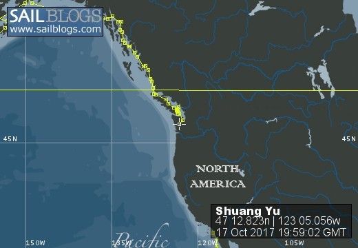
17 October 2017 | Boat position at Shelton: 47°12.82’N; 123°05.01’W
16 October 2017 | Boat position at Shilshole Marina: 47°40.65’N; 122°24.59’W
15 October 2017 | Boat position at Friday Harbor: 48°32.20’N; 123°0.59’W
27 September 2017 | Boat position on Granville Island: 49°16.35’N; 123°08.24’W
26 September 2017 | Boat position on Granville Island: 49°16.35’N; 123°08.24’W
22 July 2017 | Boat position at Granville Island: 49°16.35’N; 123°08.24’W
21 July 2017 | Boat position at Vancouver Rowing Club, Canada: 49°17.77’N; 123°07.85’W
20 July 2017 | Boat position at the Vancouver Rowing Club, Canada: 49°17.77’N; 123°07.85’W
19 July 2017 | Boat position at the Vancouver Rowing Club: 49°17.77’N; 123°07.85’W
18 July 2017 | Boat position in Active Pass: 48°51.64’N; 123°18.54’W
17 July 2017 | Boat position at Otter Cove, Pender Island, Canada: 48°47.84’N; 123°18.51’W
15 July 2017 | Boat position at Port Bedwell, Pender Island, Canada: 48 44.97'N; 123 13.97'W
14 July 2017 | Boat position at RVYC: 48 27.19'N; 123 17.73'W
13 July 2017 | Boat position at RVYC: 48 27.19'N; 123 17.73'W
12 July 2017 | Boat position at SNSYC: 48 40.44'N; 123 25.02'W
12 July 2017 | Boat position at SNSYC: 48 40.44'N; 123 25.02'W
11 July 2017 | Boat position at SNSYC: 48 40.44'N; 123 25.02'W
10 July 2017 | Boat position at Ganges: 48 51.00'N; 123 29.53'W
09 July 2017 | Boat position at Ganges: 48 51.00'N; 123 29.53'W
08 July 2017 | Boat position at Montague Harbour: 48 53.63'N; 123 24.03'W
Yoron Shima
16 June 2015 | Boat position at Yoron Shima, Japan: 27 02.94'N; 128 24.34'E
Pam Lau
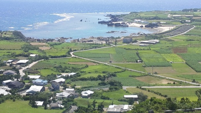
Picture: View of Yoron Shima taken from the observatory at the Southern Cross Museum.
Several members of the Japan Coast Guard visited us the second day after we arrived at Ginowan Marina, Okinawa. They were extremely courteous and took numerous pictures of our boat, especially the safety equipment such as the AIS, SSB radio, E-Perb, satellite phone and so on. We filled out some of the same forms that we had already filled out at Ishagaki. They told us that Ginowan is a "closed" port and we needed permission to be there but they dismissed their concerns after we showed them the form that stated we had changed our boat status from foreign to a domestic coastal boat. Evidently with the changed status we could go to any closed port in Japan without seeking permission from the Department of Land Claims Office. Anyway, they reminded us to call them before leaving Okinawa and so we contacted them on channel 16 at 06:30 on Tuesday as we were leaving Okinawa for Yoron Shima.
Yoron Shima is about 66 nautical miles from Okinawa so it's a day's sail for us and the wind blew from the south making it easy "downwind sailing". Out came the spinnaker pole making our ride smooth and pleasant all the way to Yoron. It was still light when we pulled into the harbor and we were not sure where to go, this being the first time we had entered a Japanese harbor without a marina. As we were dropping our anchor we saw a man riding up on a motorcycle. He signaled to us to dock at a floating pontoon, the only one in the harbor. With the help of another man he caught our lines and secured "Shuang Yu" to the dock. He told us that he was the harbormaster. We were pleasantly surprised because we called on the VHF before coming in and got no answer. We thanked him and had a wonderful night in the safe, calm anchorage.
There is an excellent road looping around the island and the grades are not too steep for a bicycle so next morning we unpacked our bikes and had a pleasurable, easy day's ride. We were told that before United States returned Okinawa to Japan in 1972, Yoron was the most southerly island in the country and domestic tourists flocked to there for holidays. Since 1972 however, Yoron is no longer at the "end of the trail" and tourists started to visit Okinawa or the other islands to the south. Hotels and other guest accommodation on Yoron lost clientele and today remain empty, reminders of a bygone era. Instead of allowing itself to become a "ghost" island, Yoron developed an intensive agricultural industry, specializing in sugar cane and other crops, and dairy. There is also a manufacturing industry which includes a sugar mill, brewery, pottery, silk textile plant and other factories producing numerous boutique foods, sauces and liquors. In addition, since 1992 the island has hosted an annual marathon, drawing runners from all over Japan and the world, especially from their "sister" island in Greece.
On the way around the island we stopped at a beach called Oganeku-kaigan, famous for a special type of sand, found only at low tide. Individual grains of sand are star-shaped! A man came up to us and showed us the sand and pointed out that some grains were shaped like moons and suns as well! Even though there were no people to be seen on this pristine beach, three ladies were selling souvenirs under large tarps. We bought some beautiful coral and shell necklaces from one of the ladies. From the beach, about 500 meters out to sea, we could see a small sand island with a few people walking on it. There was a boat moored near the island and we got the impression that a local tour operator takes tourists back and forth for a fee. We read that during high tide, the island disappears underwater.
Half way around the island we bought some ready lunch from grocery store and ate it under a nice shady tree in front of the Southern Cross Museum. The place seemed deserted. It is called the Southern Cross Museum because this latitude is the highest in the Northern Hemisphere that the "southern cross" star constellation can be seen. After we paid our entrance fee, the lady attendant advised us to take the elevator up to the fifth floor and then work our way down to the ground floor. When we stepped out of the elevator, we could not believe our eyes! The panoramic view was better than that seen from the "Space Needle" in Seattle or the "Empire State Building" in New York. We had changing views everywhere we turned. In one direction we saw rolling green hills and pale-blue skies with puffy white clouds, fringed by deep blue sea. In another direction there were various shades of green fields stretching out on the plain like a plush carpet, accented with dark green trees. Even the houses dotted amongst the greenery were an adornment to the landscape. We were the only visitors in the observatory. Cool, relaxing, air conditioning on such a hot day whilst being surrounded by such great beauty. What more can a person want? As we descended the observatory, floor by floor, we continued to observe and examine items on display in the museum. We were very impressed by this little island and thoroughly enjoyed ourselves there.
Comments
| Vessel Name: | Shuang Yu |
| Vessel Make/Model: | Catalina 400 |
| Hailing Port: | San Diego |
| Crew: | Ted Berry and Pam Lau |
| Home Page: | www.sailblogs.com/member/tedandpam/ |
| Social: |
|
Shuang Yu's Photos - Main
 |
These pictures were taken from my two favorite events in Ensenada: the "Women Spanish Class" and the "Knitters and the Dabbers"
11 Photos
Created 9 February 2011
|
 |
Van, Cida, Ted and Pam went to the Catalina Islands from 12/10 to 12/17/2010.
No Photos
Created 14 January 2011
|
Who: Ted Berry and Pam Lau
Port: San Diego