Joy of Cruising

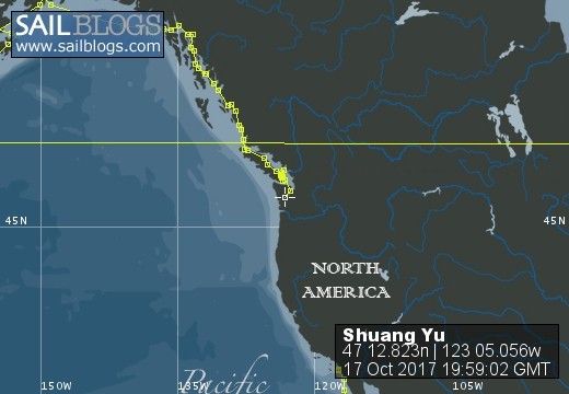
17 October 2017 | Boat position at Shelton: 47°12.82’N; 123°05.01’W
16 October 2017 | Boat position at Shilshole Marina: 47°40.65’N; 122°24.59’W
15 October 2017 | Boat position at Friday Harbor: 48°32.20’N; 123°0.59’W
27 September 2017 | Boat position on Granville Island: 49°16.35’N; 123°08.24’W
26 September 2017 | Boat position on Granville Island: 49°16.35’N; 123°08.24’W
22 July 2017 | Boat position at Granville Island: 49°16.35’N; 123°08.24’W
21 July 2017 | Boat position at Vancouver Rowing Club, Canada: 49°17.77’N; 123°07.85’W
20 July 2017 | Boat position at the Vancouver Rowing Club, Canada: 49°17.77’N; 123°07.85’W
19 July 2017 | Boat position at the Vancouver Rowing Club: 49°17.77’N; 123°07.85’W
18 July 2017 | Boat position in Active Pass: 48°51.64’N; 123°18.54’W
17 July 2017 | Boat position at Otter Cove, Pender Island, Canada: 48°47.84’N; 123°18.51’W
15 July 2017 | Boat position at Port Bedwell, Pender Island, Canada: 48 44.97'N; 123 13.97'W
14 July 2017 | Boat position at RVYC: 48 27.19'N; 123 17.73'W
13 July 2017 | Boat position at RVYC: 48 27.19'N; 123 17.73'W
12 July 2017 | Boat position at SNSYC: 48 40.44'N; 123 25.02'W
12 July 2017 | Boat position at SNSYC: 48 40.44'N; 123 25.02'W
11 July 2017 | Boat position at SNSYC: 48 40.44'N; 123 25.02'W
10 July 2017 | Boat position at Ganges: 48 51.00'N; 123 29.53'W
09 July 2017 | Boat position at Ganges: 48 51.00'N; 123 29.53'W
08 July 2017 | Boat position at Montague Harbour: 48 53.63'N; 123 24.03'W
Yakushima
27 June 2015 | Boat position at Miyanoura Port, Yakushima, Japan: 30 25.79'N; 130 34.26'E
Pam Lau
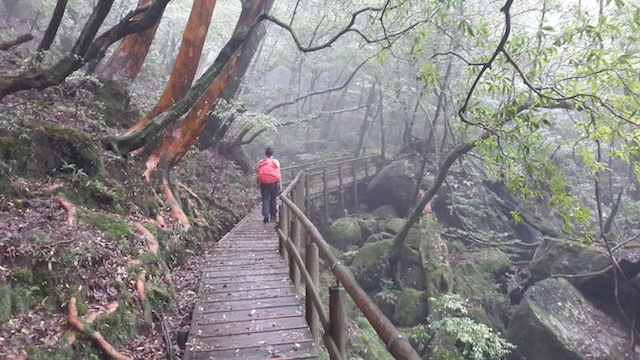
Picture: Hiking in the Shiratani Unsuikyo forest on Yakushima.
As the Coast Guard predicted, the passage from Naze port to Yakushima was unpleasantly turbulent. We knew it would be a high sea but I thought it would not as bad as the forecast suggested, however it was worse. Poor "Shuang Yu", was riding through the big waves like a man on a surfboard. At times like this, we are grateful that she is a good ocean-going boat. It was rainy, windy, high waves and strong currents. I had a glass sitting on the non-skit mat and it was flung against the wall and shattered. The kettle was tossed on its side over the food storage area and spilled water everywhere. Our stove has gimbals which make it stay level even in rough weather but I had to use my pot fastener, securing the pot onto the stove so it wouldn't slide. I have not used that since Catalina Island in California five years ago. However, I did not have to tie myself to the stove like the time near Catalina Island.
The current between Yakushima and Kagoshima was 2.8 knots against us and the head wind and rain so strong that we were actually going backwards. "Shuang Yu" totally lost steerage because no moving water was passing over the rudder. I was asleep at the time but Ted raised the mainsail just a little so we would have steerage and not be pushed in every direction. It worked! We were able to advance forward. We rounded a headland as we got closer to our destination and the sea suddenly became flat and the wind disappeared as if there had been no storm at all. Even the rain stopped and the current reduced to zero. We pulled into the harbor and docked in front of a building that looked like a fish processing plant. We prayed in thanksgiving for the safety of our trip.
Yakushima was awarded the Unesco World Heritage Site in 1993 because of its ancient cedar trees which range from several hundred years old to several thousand years old. The oldest and most famous amongst them is called Jomon Sugi, which is estimated to be 3,000 to 7,200 years old! Yakushima is also well known for its hiking trails through the craggy mountain passes and mossy valleys. The Shiratani Unsuikyo forest was the inspiration in Miyazaki Hayao's animation classic "Princess Mononoke" (Mononoke Hemi) in 1997; the film was release two years later in the United States. I read about Yakushima in Lonely Planet when we first arrived in Japan and I was looking forward to visiting the island. However, it warned that it is one of the wettest places in Japan.
A welcoming downpour came the following morning. While I was doing my yoga routine and Ted was still asleep, I heard a car horn. A car was parked next to "Shuang Yu" on the dock. I ignored it hoping it would go away. An hour later, I heard someone boarding the boat; this time, I could not ignore the situation and went out to look. A man with his umbrella was standing outside of our cockpit saying something in Japanese. I understood that he wanted us to move but "where?" I asked. He pointed to a piece of paper, which he had left by the hatch. It said, "Please do me a favor�... move" and showed a drawing of where to go. I thanked him and we moved immediately. The new position was closer to the sea. We docked alongside a shell-covered sea wall with all our fenders to protect against its rough surface. I cleaned the boat inside because it looked like it had been hit by a tornado and then we visited the tourist center nearby to get an idea of the trails and bus system. Afterwards we walked around town to familiarize ourselves with the area. There is a small park near the harbor and bus stop, a small grove of large pine trees stood tall on lush green grass. In the park was the nicest, cleanest, public toilet I have ever seen. It was like a model building, circular shaped and totally built of cedar. The floor was polished and required people to slip off their shoes and wear slippers which were provided!
The following morning was clear and sunny! Since we could not rent a car without an international driving permit, we had to take the bus. I bought two, three-day passes for about $US50 to go anywhere on the island. It sounded like a good deal. My idea was to hike a shorter and easier trail the first day and the following two days we could hike over-night; that way we would get the most out of our bus tickets. We also rented some hiking boots and some raingear for Ted. Needless to say, my plan flopped like a rotten fruit but in the end things turned out perfectly.
First of all, we missed the bus to the Shiratani Unsuikyo National Forest in the morning. The next bus would not come for four hours. We scratched plan A and resorted to plan B. The battery in our Samsung phone could not charge anymore, which means that we have no Internet. It is a critical problem for us because Internet is our main source of communication with the world as well as for navigation. Our plan B was to visit a phone company (Docomo) in Anbo, the next largest town, to see if we can solve the phone issue. While Ted went back to the boat to get the SIM card contract, the bus came and went. Again we missed the bus and we had to wait another hour and half before the next bus. It was absolutely frustrating.
The bus finally came and we were able to visit the phone company. The man spoke very little English but communicated to us that our cell phone battery is good but the terminal to charge the phone is damaged. He put the SIM card in our first generation iPad so we could use it for Internet but not as a hotspot because it did not support that type of technology when it came out five years ago. He spent over an hour with us and did not charge us. We were thankful to have Internet. We walked down to the small airport hoping to catch a bus to the museum in Anbo. While we were eating our crackers at the bus stop, a man pulled up in a car and asked where we were going. We had no idea but we told him the closest waterfall to the airport because we wanted to see at least one of the tourist destinations. He said "okay" and we got into his car. Later we learned his name, Nomoto. He speaks almost no English and our Japanese is nil so we rode in silence most of the time. We stopped at the Torohki-no-taki waterfall, short distance from the road. We were prepared to get out of the car with our packs but he motioned to us that we don't need to. We could not figure his motive for giving us a ride so Ted confronted him and said we don't have enough money for driving around the island. Nomoto seemed to understand said, "No, no, no money" so we continued with him. It turned out that he just wanted to show us his island, a very nice man. He worked in confectionary. When we got to the hot spring (onsen) by the sea, we wanted to get out and soak in the hot mineral water. Again, he made an "X" with his index fingers, which is a universal symbol for "no". We could not understand why he said "no" but think it was because the sea water was not very hot or clean like an onsen should be. Again, we followed him to the car and drove to see another onsen, like having a personal driver and guide. The souvenir shop charges $US80 per person per day by bus for a tour of the island. Nomoto stopped at two more waterfalls, each one more spectacular than the other one. Then we drove to a village, where a huge curtain fig tree resides and artistically forms an archway. Next we drove through a dense tropical forest on a mountain road and saw groups of deer and monkeys on, or near, the road. Obviously they were not afraid of humans because they just stood still and let us take pictures of them.
The most pristine beaches are located on the northwest coast. Nomoto stopped a couple times for us to look at green sea turtle tracks and the holes where they lay their eggs. The tracks we saw were quite fresh because the tide had not yet washed them away. The holes were about 3 or 4 feet across and partially filled back in by the turtles. Nomoto said the eggs are about one meter below the bottom of the holes. The Japanese are very protective of the turtles. The do's and don'ts are listed on a big chart in the car park. Nobody will disturb the eggs even though they are just a few meters away, such is the nature of Japanese people.
Nomoto took us back to "Shuang Yu" and we invited him aboard to have a cup of coffee. After the coffee and chat in sign language we invited him and his wife over for dinner on the Friday but they did not show up. We were overwhelmed with his generosity taking us on a complete tour of the island and never asking anything in return. In all our travels, we have never experienced such kindness. We hope we can learn from these exemplary models.
The day after we arrived at Yakushima, another boat tied up next to us. It was called S/V "Umehara Keiichi", manned by Captain Shinichi and his friend Taki from Tokyo. They were colleagues from their university days and friends from their local sailing club. Shinichi was in technology and now retired and Taki is an architect and still working. Shinichi gave Ted many good tips on various anchorages and marinas that we could visit. The day we left, Taki flew back to Tokyo and Shinichi planned to continue to Okinawa.
The following day, Ted and I were all ready to hike the trail to the most famous ancient cedar tree and planned to spend the night in a mountain hut and then return the next day. Shinichi and Taki rented a car and asked if we would like them to take us to the trailhead. The mountain road was steep, curvy, narrow and wet. Yes, it was pouring down rain nearly all the way up there. We stopped at the ranger's station and he warned us about several places that we could not go because of flooding. He also said that the trail we wanted to take was badly marked and it would be easy to loose our way. Back in the rental car we spiraled our way further up the mountain and soon arrived at the trailhead. The rain was bucketing down and Ted said later he felt a slight twinge of fear at the prospect of hiking through the wet jungle in the pouring rain on an indistinguishable trail. We stood and gazed at the trail map on the billboard while rainwater dripped down on our faces. Our raingear and boots were already soaking wet. I looked over to Taki (he's more fluent in English) and said, "Do you mind if we change our mind and go back home with you?" I think Ted was relieved that we did not go through with my plan. On the way back we had a hot bowl full of udon (thick rice noodle) soup at a restaurant in town and then went back to the boat.
On our third and last day of the bus pass and boot/rain gear rental, we felt we had to go hiking somehow, just to get our monies worth. The wind was gusting all night long and I heard Ted getting up several times to check on the lines which secured us to the wall. Just before we were off to catch the bus, wind and rain came across full blast pushing us hard against the concrete wall. The stainless steel tubing that holds the canvas over the cockpit took off in the wind so we had to tighten it down again. It broke a couple of zips and ripped some canvas but we were able to fix the zips and replace the ripped section of canvas with a spare that we carry. We sat back down in the cockpit with our raingear and boots on and watched torrential rain and windstorm. The eight o'clock bus came and went and we prepared ourselves to leave on the ten o'clock bus. Again the same velocity of rain and wind came and stopped us from leaving the boat. We thought maybe that was an omen that we should not go and we were about to give up the idea of hiking in one of Japan's wettest areas. However, just before the two o'clock bus, magically the rain cleared and the wind calmed down. Quickly we went out and caught the bus to Shiratani Unsuikyo National Forest. It was a windy, steep climb from Miyanoura Port to the national park; the distance was only 12 km (about 9 miles) and it only took 30 minutes. The scenery was spectacular; panoramic views of the valley and Port Miyanoura, steep lush green slopes, ravines with rivers and healthy straight cedar trees (Yakusugi).
The bus stopped in front of the ranger station next to a rushing, swollen river. We paid our fee of $US5.00 for the two of us and started up a wooden boardwalk. There were three different hiking trail courses, one-hour, three-hours and four-hours. Since it was already after three in the afternoon, we chose the one-hour course, in order to catch the last bus at 4:30 p.m. We were appreciative of our opportunity to see such beautiful forest while it was not raining. I could see why it would be an inspiration for the setting in Miyazaki Hayao's animation classic, Princess Mononoke. There was a mysterious feeling inside the foggy, mossy green world with dampness oozing out of every crevice. Each twig, branch, rock and stream seemed to have a spirit - it was magical. The trail was easy and quite relaxing with wooden steps and soft felt-like material on the slippery areas. We got to see two ancient, indigenous cedar trees (Yoyoisugi and Nidaiohsugi) in different locations of the trail. They were magnificent, like noble monarchs! We could not help but respect their massive size and longevity! Even though the hike was short, it was like fulfilling a dream, difficult to achieve but super rewarding. Yakushima; an unforgettable island, stunning but challenging.
Comments
| Vessel Name: | Shuang Yu |
| Vessel Make/Model: | Catalina 400 |
| Hailing Port: | San Diego |
| Crew: | Ted Berry and Pam Lau |
| Home Page: | www.sailblogs.com/member/tedandpam/ |
| Social: |
|
Shuang Yu's Photos - Main
 |
These pictures were taken from my two favorite events in Ensenada: the "Women Spanish Class" and the "Knitters and the Dabbers"
11 Photos
Created 9 February 2011
|
 |
Van, Cida, Ted and Pam went to the Catalina Islands from 12/10 to 12/17/2010.
No Photos
Created 14 January 2011
|
Who: Ted Berry and Pam Lau
Port: San Diego