Joy of Cruising

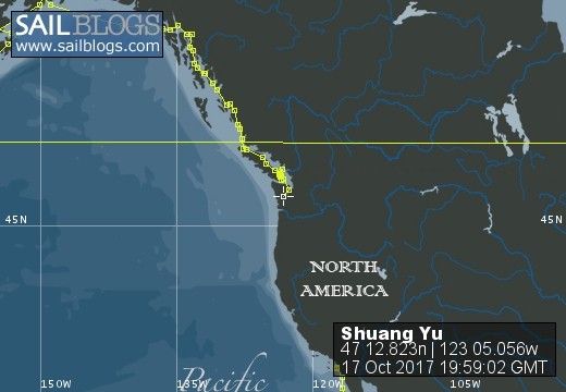
17 October 2017 | Boat position at Shelton: 47°12.82’N; 123°05.01’W
16 October 2017 | Boat position at Shilshole Marina: 47°40.65’N; 122°24.59’W
15 October 2017 | Boat position at Friday Harbor: 48°32.20’N; 123°0.59’W
27 September 2017 | Boat position on Granville Island: 49°16.35’N; 123°08.24’W
26 September 2017 | Boat position on Granville Island: 49°16.35’N; 123°08.24’W
22 July 2017 | Boat position at Granville Island: 49°16.35’N; 123°08.24’W
21 July 2017 | Boat position at Vancouver Rowing Club, Canada: 49°17.77’N; 123°07.85’W
20 July 2017 | Boat position at the Vancouver Rowing Club, Canada: 49°17.77’N; 123°07.85’W
19 July 2017 | Boat position at the Vancouver Rowing Club: 49°17.77’N; 123°07.85’W
18 July 2017 | Boat position in Active Pass: 48°51.64’N; 123°18.54’W
17 July 2017 | Boat position at Otter Cove, Pender Island, Canada: 48°47.84’N; 123°18.51’W
15 July 2017 | Boat position at Port Bedwell, Pender Island, Canada: 48 44.97'N; 123 13.97'W
14 July 2017 | Boat position at RVYC: 48 27.19'N; 123 17.73'W
13 July 2017 | Boat position at RVYC: 48 27.19'N; 123 17.73'W
12 July 2017 | Boat position at SNSYC: 48 40.44'N; 123 25.02'W
12 July 2017 | Boat position at SNSYC: 48 40.44'N; 123 25.02'W
11 July 2017 | Boat position at SNSYC: 48 40.44'N; 123 25.02'W
10 July 2017 | Boat position at Ganges: 48 51.00'N; 123 29.53'W
09 July 2017 | Boat position at Ganges: 48 51.00'N; 123 29.53'W
08 July 2017 | Boat position at Montague Harbour: 48 53.63'N; 123 24.03'W
Kanmon Kaikyo strait
14 August 2015 | Boat position at Kanmon Kaikyo strait, Japan: 33 54.147'N; 130 53.947'E
Pam Lau
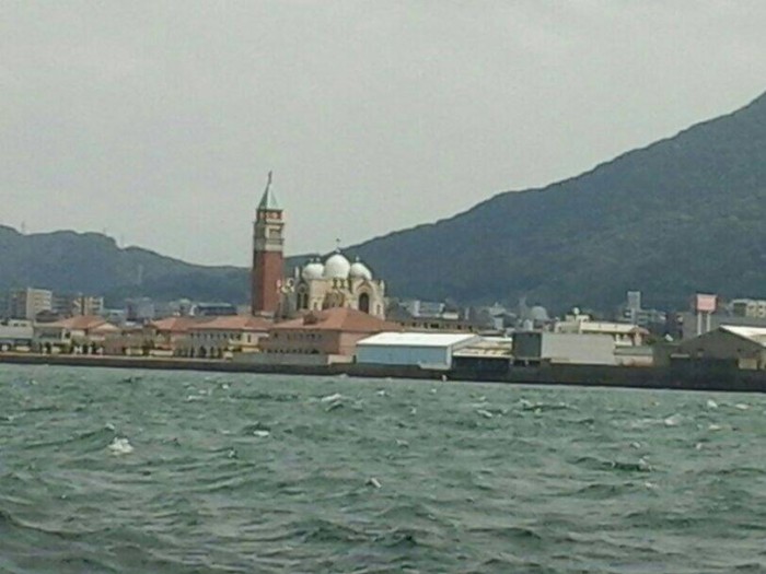
Picture: Some familiar looking buildings on the south bank of the Kanmon Kaikyo strait, probably used for wedding ceremonies.
We read and researched extensively about going through the 10 nautical mile long Kanmon Kaikyo channel (the strait between the two large islands, Kyushu and Honshu.) The current flows at 8+ knots so we would not want to enter the strait during a wrong tide since our maximum speed under power is only 6 knots. The website http://www.mirc.jha.or.jp/cgi-bin/w/w-tcp?AREA=kanmon was very informative about tides so we able to calculate when to go in.
We arrived there just when the tide turned in our favor. There is an electronic screen strategically placed on the bank at the entrance to the strait showing the direction of the flow (E or W), the speed of the current, and the arrow showing increasing or decreasing. When we went in it said, "E 7 increasing). Large ships are required to check in via VHF Channel 16 so "Kanmon Martis" (Kanmon channel control) was constantly on the radio. Communication is in English most of the time. It was like crossing the Singapore Strait; we had to dodge countless large ships, even though we stayed outside of the shipping lane.
The strait is "U" shaped and at the narrowest point, the bridge, it is less than 0.3 nautical miles wide. On our way in from the west, we passed some very large wind-generators, some actually in the sea, as well as a large industrial city called Kitakyushu. The latter was supposed to be the primary recipient for the second atomic bomb to be dropped during WWII. It was fortunate for Kitakyushu that, because of too much cloud cover, the bomb was dropped on Nagasaki where the large Mitsubishi munitions works and ship yards were located. The bridge was the last bit of trepidation for us because of the stronger current but we did not encounter any real difficulties. The anticipation is worse part of the crossing; we went through it smoothly and quickly.
Comments
| Vessel Name: | Shuang Yu |
| Vessel Make/Model: | Catalina 400 |
| Hailing Port: | San Diego |
| Crew: | Ted Berry and Pam Lau |
| Home Page: | www.sailblogs.com/member/tedandpam/ |
| Social: |
|
Shuang Yu's Photos - Main
 |
These pictures were taken from my two favorite events in Ensenada: the "Women Spanish Class" and the "Knitters and the Dabbers"
11 Photos
Created 9 February 2011
|
 |
Van, Cida, Ted and Pam went to the Catalina Islands from 12/10 to 12/17/2010.
No Photos
Created 14 January 2011
|
Who: Ted Berry and Pam Lau
Port: San Diego