
Offshore Hawaii
31 July 2011 | 48 43'N:125 35'W,
26 July 2011 | 47 14'N:140 33'W,
22 July 2011 | 44 38'N:152 26'W,
20 July 2011 | 42 54'N:157 44'W,
18 July 2011 | 39 16'N:159 15'W,
16 July 2011 | 34 20'N:159 34'W,
15 July 2011 | 31 56'N:159 31'W,
15 July 2011
12 July 2011 | 26 20'N:157 16'W,
21 June 2011 | 20 58'N:154 00'W,
18 June 2011 | 26 04'N:148 28'W,
16 June 2011 | 29 05'N:144 27'W,
14 June 2011
14 June 2011
14 June 2011
14 June 2011
14 June 2011
27 May 2011 | Semiahmoo Marina
12 May 2011
Final Days Before Landfall �...
31 July 2011 | 48 43'N:125 35'W,
There has been a brief hiatus since my last posting to the blog and a good reason for it. With Cape Flattery in sight at 50 miles with landfall expected late this evening, everyone on board is breathing a sigh of relief -- and so the story unfolds!
Three days ago when we were still 350 nautical miles offshore, we began experiencing critical problems with power. You will recall earlier postings about my references to the necessity of conservative power usage because of challenges on the battery banks. It had become obvious over the course of the previous 7-10 days that the situation was deteriorating and we were finding it necessary to run the engine more frequently in order to keep up the condition of our battery bank to operate what we had already decided are critical uses including refrigerator and navigational equipment.
This accelerated recharging schedule was creating additional stress on our fuel reserves, and not without some trepidation. We were noting from other sailing vessels ahead of us on the route reporting their check in with the nightly SSB reports, that it was quite common to be becalmed prior to entering the Strait with many of the vessels having to steam in under engine power.
Quite suddenly at 11 PM, just as we were changing watches and recharging our batteries by running the engine, our ability to produce any power to recharge our battery banks unexplainably failed. We were uncertain as to whether not the failure rested with a short-circuit which was depleting our power bank supply or whether or not the problem related to failure of the alternator. (electrical generator attached to the diesel engine to produce power supply to the battery banks).
We were now faced with a situation of approximately 10 hours of useful power and questionable capability of restarting our diesel engine as it appeared that the leakage problem also affected the cranking battery for the diesel engine.
In order to preserve all power, decisions are made to shut down all power sources not critical to navigation including the refrigerator, all indoor lights, water pressure to run galley and cabin needs, gas to the stove because of the need to support solenoid controls, water maker etc.. Running lights and radar would only be turned on if we were to make visual contact with another ship at sea. Under those circumstances, we expected to have ability to run our auto helm as well as use of the navigational equipment at the helm for approximately 8 hours.
When those power uses depleted the bank, we would be forced to hand steer the boat home with only handheld GPS devices for navigational aids along with our paper charts. Without engine power, we would not be able to sail a dock and would require finding a sheltered bay to drop our anchor and use our satellite phone to arrange for a tow to services.
It would also mean that we would have to change our watches to one hour at the helm as it is particularly difficult to hold the course by compass at any time, particularly in the darkness of night -- a grueling and exhausting ordeal. There are no landmarks to steer to and with 100% cloud cover and no stars and moon to take bearings from, you can only guide yourself by following the compass course lit by your headlamp directed on the binnacle.
We also made the decision to change out the alternator to a spare alternator that had been pulled from the boat and stowed away before the present alternator had been installed. It did not have the same wiring diagram and would require jury rigging to make it work with the regulator in place.
This job would have to be done by flashlight at midnight in rolling seas with following winds at 20 kn. and it was done.
Turning the key to start the engine confirmed our worst fears -- the engine battery was dead, fortunately the ignition is built-in with an accessory parallel relay switch that allows ability to recruit what power was left in the engine house batteries to the task of turning over the engine and the engine hesitatingly came to life. Watching anxiously to see whether or not the line voltage would come up on our panel analog readout, we gradually noted a slow but steady rise indicating that the new alternator was functioning at producing power to regenerate our battery banks.
Breathing a sigh of relief that our options had been restored, it was only a matter of letting the engine run for several hours to see what level we could restore the battery banks to. By morning it looked like we had the problem in hand, but we were still unable to explain why we were incapable of recharging the engine battery, but were somewhat reassured that the option of turning the engine over using that accessory relay switch from the house bank would continue to function.
Just when we thought we had a handle on the problem -- the next disaster struck the following night. Why does everything happen in the dead of night?
We were in the process of scheduled recharging our batteries at 11 PM at change of watch by running the engine, when all of a sudden there was this terrific banging racket. No one could identify where it was coming from. Initially we thought that it was the mainsail or controlling lines flogging because of a wind shift, but in the black of night you cannot see your sails to confirm your impressions. The racket eventually settled down after 30 seconds and we thought the problem had resolved itself.
2 min. later engine alarms blared out indicating an overheating engine. The engine was shut off immediately and on examining the engine hold it was obvious that the fan belt that have been running the new alternator had disintegrated. It was this disintegration that had been responsible for the racket previously heard. Fortunately we had 2 spare alternator belts and again in the middle of the night installed the new fan belt without any engine damage obvious on restarting the engine.
The last 16 hours have been trouble-free and it is a beautiful sunny day as we look on the Olympic Peninsula. I don't think any of us have been more pleased to see landfall.
Be careful what you wish for! -- I recall mentioning in a blog at the beginning of the voyage that one of the main purposes that I hoped to achieve on this voyage was a significant familiarity with the different systems on Telltales, and confidence in correcting or repairing any deficiencies. At this point of time I think I know far more than I want you -- some problems are much easier to accept as academic exercises then real life challenges!
Back on the Air!
26 July 2011 | 47 14'N:140 33'W,
We lost our satellite phone connection on Friday when the sat phone company dropped the ball and failed to institute additional minutes to my account. We did have our contact through e-mail with the sideband radio but it is appreciably slower and therefore no blog was uploaded.
We have had to change our plans and terms of use of radar because our present route places us on the Great Circle Routing from Japan to San Francisco and we are seeing considerable traffic sometimes up to 3-4 ships per day. This brings me to the question of how sharp their lookouts are on watch.
You often hear stories of freighters arriving in port with masts and rigging of sailing ships tied up in anchor chains and it makes you cringe at the thought of this disaster. We have had freighters pass within a mile and a half of us and they have consistently failed to answer radio calls to alert them of our presence. This is in spite of us running our rigging lights as well as a strobe at the top of our mast which must make us stand out like a Christmas tree.
You are definitely low man on the totem pole out here and have to make sure that you keep well out of their way. With the fog we are often running our radar during the day as well, as visibility can sometimes be down to 2-3 miles which gives you little time to react if you have a rogue freighter bearing down on you.
We're also seeing more sea life and a couple of days ago were visited by a group of porpoises as well as an orca. Unfortunately no one had their cameras out so you'll just have to take my word for it.
We are now approximately 650 miles north of Cape Flattery having made the turn at the top of the Pacific High. It's hard to believe that it's July in the Pacific Northwest with temperatures of 12°C. We have so much wool on that we're starting to look like Michelin men. In any case, it gives us opportunities to try out our warm gear including our survival suits at night when temperatures are bitterly cold. The good news is that we are being blessed with good Northwest winds at 15 kn makes a pleasant sail at an average of 6.5 kn.
It doesn't seem like it's very fast but at this steady pace, you are covering the equivalent of walking a golf course every hour. In a watch of 6 hours you will cover the distance of White Rock to Horseshoe Bay. In the course of 24 hours, we make the equivalent of two round trips. Do that for 6 weeks that you can cover over 5000 miles as we will have done!
This Is VE7 TLZ -- Do You Copy? -- Over
22 July 2011 | 44 38'N:152 26'W,
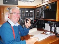
In previous blogs I have briefly mentioned our contact with the Pacific Maritimers Net over our single side band radio each evening at 0300 Zulu time (Universal or Greenwich). Sailing vessels traversing large bodies of water rely almost exclusively on this lifeline to keep in touch with other maritimers on similar routing to anticipate weather changes or alert traffic behind them of possible changes in weather patterns.
Moderators on these networks also patch maritimers through to experts, (medical or other technical matters), to assist in resolving difficulties they may be experiencing on route. We in fact used one of these patches on the first leg to Hawaii patches when Fred from Florida patched us through on a phone line to alert people who we knew were following us that we were experiencing communication problems but were otherwise okay.
Kevin, the crew member in the attached photo, has spent his entire professional career in radio communications; a retired career military man, he has also been an avid ham radio operator throughout the course of his life. Not surprisingly he is the man on the scene aboard Telltales.
On another note yesterday, we were visited by two leviathans from the deep; a gray whale mother and her calf. They stayed alongside the boat for 10 or 15 min. and then slipped away. It was quite surprising because normally we expected that their migratory route would keep them much closer to shore.
Other than that, our only visitors on a daily basis are the storm petrels; two species, Leach's Storm Petrel and Black Storm Petrel as well As Shearwaters which constantly are on the move about us with a tremendous expenditure of energy but we have never seen them feed as of yet.
We have now made the turn at the top of the Pacific High and are in the shute with westerlies pushing us towards Cape Flattery and Juan de Fuca Strait in 20 kn winds and following 15-20 foot seas. We have now voyaged 1736 miles from Hilo Hawaii and are 1157 miles from Cape Flattery.
Regrettably, we are back into our woolies and foul weather gear -- a sure reminder that we're back into the Pacific Northwest!
Life Aboard -- DAY 12
20 July 2011 | 42 54'N:157 44'W,
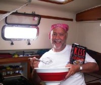
One of the important critical rituals each day is breakfast and supper. Lunchtimes are pretty well left to the individual rooting around in the refrigerator either for leftovers or making do with energy bars and other snacks stowed away in various holds. If you discover something particularly appetizing in one of the holds that you have forgotten about, you are sometimes tempted to keep silent about the stash, or feeling more generous may choose to offer it around!
I have been elected the premier "Galley Wench and Scullery Maid" which gives you some indication of the talent of the crew when it comes to culinary skills! With little else to do however I made certain that I had packed one or two recipe books aboard and have taken it upon myself to prepare something special in the oven each day to liven up the ritual meals. If anything it breaks up the day and the crew is appreciative of my efforts.
Another aside -- as of yesterday as we approach the top of the Pacific High and prepare to find the westerlies to push us home towards Juan de Fuca Strait, I made some calculations off our chart as to the distances of various landmasses. Hilo is now directly south of us at 1314 miles. The closest landmass is the tip of the Aleutians north of us at 823 miles. Interestingly enough both Russia and Japan are equidistant at 1921 miles further west to us. Homeport at Semiahmoo is 1596 miles away.
I guess you could truly say we're in the middle of nowhere!
Finer Points on the Pacific High
18 July 2011 | 39 16'N:159 15'W,
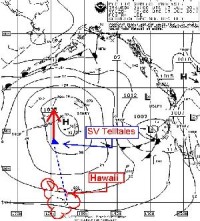
As you may have gathered from recent mentioning in the blogs, everything is dependent on the central position of the Pacific High and our relative position to it. The key is to steer a course which gets us to the outside of the center without getting too far afield westerly making up the extra distance that we have to go east in order to make landfall at Juan de Fuca Strait or pinching it too much that we actually get caught in the center without the benefit of having any wind.
Seeing as how it is so central to this voyage -- I thought I would enclose a copy of an illustrative synoptic weather chart and some comments relating to it.
Each day we download the enclosed synoptic weather charts () seen in the inset attached to this blog. As you can see from our position we're nearing the center position of the Pacific High steering a course of 345° T. This puts us on the 159° W longitude meridian which is pinching it a bit tight but at the same time if we make it, it saves us having to make up the westerly course where some of our fellow ships in the fleet ahead of us have gone as far afield as 164° W longitude before making the turn.
Everybody seems to be making the turn at about the latitude of 42-43° north so we expect to reach that point in about 36-48 hours.
More shall be revealed!
Imagine That �-- What Would Be the Odds?
16 July 2011 | 34 20'N:159 34'W,
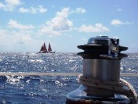
At first light this morning, we discovered the first of a fleet of sailing ships off our port quarter approximately 2 miles astern.
Raising the new arrival on our VHF we found out the vessel was a leader in a fleet of five traditional Cook Island sailing catamarans traveling from the Cook Islands to San Francisco via Honolulu.
Over the next few hours, 2 more of the sailing ships came astern and moved ahead of us on their way and if the other two vessels are on the same tack, it is likely we will see them as well before sundown.. Slightly larger and different hull shape, they're capable of moving faster through the water than our monohull vessel.
We have been traveling 900 miles with only one freighter only distantly sighted and here we see 3 sailing vessels all in one day.
We traveled the entire first leg of the trip from Cape Flattery to Hilo, Hawaii sighting only 4 vessels in the entire 2500 nautical mile trip.
The ocean is so unbelievably expansive and yet in one day it looks crowded. What a small world!
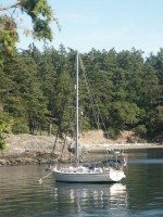
| Vessel Name: | S/V Telltales |
| Vessel Make/Model: | Island Packet 40 |
| Hailing Port: | Semiahmoo Marina |
| Crew: | Steve, Heather, Wayne, John, Kevin, Mark |
Gallery not available
S/V Telltales
Who: Steve, Heather, Wayne, John, Kevin, Mark
Port: Semiahmoo Marina