
Offshore Hawaii
31 July 2011 | 48 43'N:125 35'W,
26 July 2011 | 47 14'N:140 33'W,
22 July 2011 | 44 38'N:152 26'W,
20 July 2011 | 42 54'N:157 44'W,
18 July 2011 | 39 16'N:159 15'W,
16 July 2011 | 34 20'N:159 34'W,
15 July 2011 | 31 56'N:159 31'W,
15 July 2011
12 July 2011 | 26 20'N:157 16'W,
21 June 2011 | 20 58'N:154 00'W,
18 June 2011 | 26 04'N:148 28'W,
16 June 2011 | 29 05'N:144 27'W,
14 June 2011
14 June 2011
14 June 2011
14 June 2011
14 June 2011
27 May 2011 | Semiahmoo Marina
12 May 2011
Finer Points on the Pacific High
18 July 2011 | 39 16'N:159 15'W,
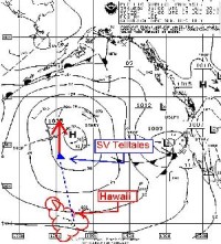
As you may have gathered from recent mentioning in the blogs, everything is dependent on the central position of the Pacific High and our relative position to it. The key is to steer a course which gets us to the outside of the center without getting too far afield westerly making up the extra distance that we have to go east in order to make landfall at Juan de Fuca Strait or pinching it too much that we actually get caught in the center without the benefit of having any wind.
Seeing as how it is so central to this voyage -- I thought I would enclose a copy of an illustrative synoptic weather chart and some comments relating to it.
Each day we download the enclosed synoptic weather charts () seen in the inset attached to this blog. As you can see from our position we're nearing the center position of the Pacific High steering a course of 345° T. This puts us on the 159° W longitude meridian which is pinching it a bit tight but at the same time if we make it, it saves us having to make up the westerly course where some of our fellow ships in the fleet ahead of us have gone as far afield as 164° W longitude before making the turn.
Everybody seems to be making the turn at about the latitude of 42-43° north so we expect to reach that point in about 36-48 hours.
More shall be revealed!
Comments
| Vessel Name: | S/V Telltales |
| Vessel Make/Model: | Island Packet 40 |
| Hailing Port: | Semiahmoo Marina |
| Crew: | Steve, Heather, Wayne, John, Kevin, Mark |
Gallery not available
S/V Telltales
Who: Steve, Heather, Wayne, John, Kevin, Mark
Port: Semiahmoo Marina