Tokimata's Travels
| Vessel Name: | Tokimata |
| Vessel Make/Model: | Ganley S130 steel cutter |
| Hailing Port: | Coromandel, New Zealand |
| Crew: | Peter, Rachel, Danny and Tom Garden |
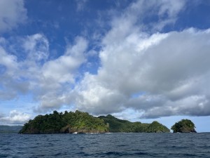
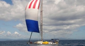
06 September 2023 | Bahia Nonda
Panama Pacific Coast
It’s now well over a month since we left Panama City. La Brisas the free anchorage on the long causeway joining three islands, was free but not the greatest pace to stay, with poor holding and many disintegrating boats, but this amazing backdrop of skyscrapers behind. These free places where yachts [...]
07 August 2023
Panama City
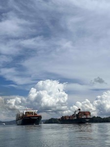
We fuelled up on 20th July 2023 and filled with water, ready for the passage through the Panama Canal. We were to leave around 2 pm next day, staying overnight in Gatun lake with our local line-handlers, and should be through by 3 pm on the following day.
21 July 2023
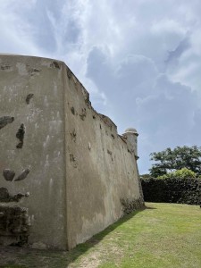
Rio Chagres and Portabelo on the Caribbean coast of Panama.
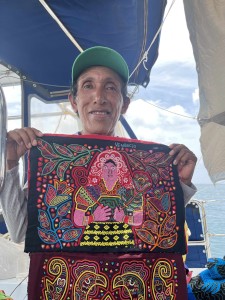
We left the San Blas islands on July 10 2023, after a last visit to Ivin, the wonderful chef at Hollandais Cays. He gave a few more image files for his recipe book and we bought his terrific coconut cake one last time. At 11.30 we upped anchor and were off on our way back east, the transit through the [...]
13 July 2023
The islands of San Blas
On Friday 23rd June at last we headed across the busy canal entrance from Shelter Bay marina and into the Caribbean sea. We were sailing to the San Blas islands, Kuna Yala to the inhabitants, hundreds of small islands and coastal villages that are still administered by the indigenous owners of the land. [...]
30 June 2023
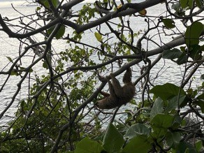
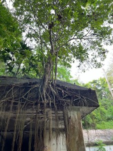
The jungles of Panama
Grinding rust on the hull of Tokimata eventually gave way to grinding rust on the decks, but this was made much easier by hiring energetic boatyard workers. Eventually this progressed to painting, using two part polyurethane over the various anti-rust treatments and primers they had applied. However [...]
07 June 2023
Two weeks in Panama
We arrived in Panama City Tuesday 23rd May from Manchester, with our usual heavy luggage: this time a Starlink system was the bulk of it along with other boat essentials. After travel via Amsterdam we arrived at last to see our taxi-driver holding a “Mr Peter” sign and were off for the hour and a [...]
King William Island - ghosts of the past
For two days at Cambridge Bay we had been watching the ice charts and weather forecasts for Victoria Strait. Strong south easterlies had been blowing around the top of King William Island and although the ice chart showed a big chunk of old ice (9/10th) locked in around the top of King William Island and extending way up north, we figured it might have blown away to the northwest by the time we got there. Close to the coast of King William Island Pete kept checking our e-mail to see if the Monday ice chart had arrived. It came in about 5pm from our daughter Kitty in Costa Rica who has been downloading the ice chart images as soon as they are published, then reducing the file size and converting to a Jpeg2000 format so they can be sent as small e-mail attachments to us. (Thank you Kit!) A 40kB ice chart image takes about 20 minutes to download on the HF/SSB radio e-mail. The chart showed the ice had moved a little west off the north coast of King William Island, but most importantly it had a big arrow showing it was expected to keep moving at 8 miles per day. Ice was still locked in nearly solid on the NE tip of the island. We continued, hoping it would clear enough to let us through in the next 24 hours.
Ice behaves in mysterious ways, or at least it appears to until you get used to it. It is influenced by current and wind but it is often hard to tell which will have the greater effect - especially when the two forces are opposed. The coriolis force is also important, pushing moving things off course because of the gyroscopic effect of the spinning earth. This is the force that makes weather systems rotate as they move (highs go anti-clockwise for us in the south, but confusingly an anti-cyclone goes clockwise in the north!) This makes northern hemisphere ice track at about 30 degrees to the right of the direction the wind tries to blow it. So trying to figure out what these huge areas of pack ice are going to do is a skilled job and we rely on the Canadian Ice Service charts to help us with these predictions.
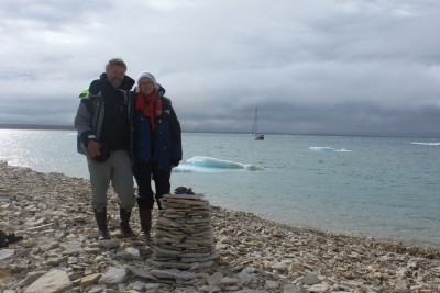
We got to Victory Point around 9 am on Tuesday and together with Sol anchored just south of the point and went ashore. Victory Point had been named by Ross in the 1820's and marked the furthest point of his exploration. This is where Franklin's men came ashore in 1848 after abandoning their big ships Erebus and Terror that had been locked in ice 20 miles to the northwest for two years. What a desolate place, all flaking rock, flat, no shelter or features at all. There is nothing much left of the cairns they built where their last messages were found, and nothing of the smaller wooden boats they hauled ashore and dragged south along the coast. An almost complete lack of any life is the main impression, - no tundra just a few tiny plants in some rocky crevices, though we did see fox and perhaps goose droppings and a couple of feathers. A few small cairns mark other visitors (one thing the flaking rock is good for!) and a small wooden shield "Made in Britain" on the back but the metal plaque on the front side ripped off.
Large pieces of pack ice were bearing down on our anchored boats and we each had to move a couple of times. But before leaving we drove the dinghy up on a large ice flow, and clambered around - slippery and fun!.
We next headed north and around the Cape Felix, the north tip of King William Island, and ahead the Clarence Islands and Boothia Peninsula 50 miles away. Yesterdays ice chart had shown as 6/10th pack ice, not passable for sailboats, but just in time a new chart came from Kitty showing the pack had moved NW again and we could skirt along just below it. We dodged a few big flows, and some 1km long chunks of decaying pack ice and made it across James Ross Strait and into the clear water running all the way north up the west coast of Boothia. The dense fog came and went throughout the day with visibility down to 100 metres at times. At one point I could hear the strange sound of lapping waves - characteristic of small waves chattering under the overhanging edges of large ice floes, then a minute later the ice comes out of the fog and we found ourselves in a bay in the middle of the pack ice and a sharp about turn was required amid flapping sails and a hastily started engine. We crunched into the relatively soft decaying pack ice and then backed out of the cul de sac and went around. Our radar detects most of the ice, but these very flat pieces of decaying pack do not show up well.
While we took this scenic tour shortcut across Victoria Strait 2 or 3 west bound yachts have taken the longer route down James Ross Strait and Simpson Strait around the bottom of King William Island - we heard this from Upchuck who had taken the same route but eastbound. It seems that as wellas our group of 4 boats from the west, there are 8 or 9 going the other way. Although we have the detailed Canadian paper charts for this area, and electronic charts on our chart plotter, the area up the west side of King William Island is completely uncharted - just a big white space on the chart. So we had to keep a constant eye on the depth sounder, but it remained deep quite close into shore and we could anchor in 4m of water only 200 metres from the beach. As we worked north up the coast of the island we followed the 20 meter depth contour about a 1/2 mile off shore. Why this area has never been surveyed I don't know, as it is quit accessible and obviously of historical interest. In Cambridge Bay we compared electronic charts between boats. Sol, Upchuck and Tranquilo were all using Navionics charts, whereas we have C-Map. The other boats noted that their electronic charts had no detail for the Simpson Strait area, a very tricky piece of water, even though a detailed chart is published for that area. However our C-Map cart cartridge had the full detail for that area. So much for all the chart plotter cartridge suppliers claiming they have every chart for their area loaded on the cartridge. The charts for the arctic are pretty sparse at the best of times and one has to navigate with a fair degree of caution, and with an eye on the depth at all times. There are also significant datum errors which can put you over land on the plotter while happily sailing in clear water.
Another factor in navigation is the proximity of the north magnetic pole to this area. On approaching the earth's magnetic poles the direction of the magnetic field tends more and more to the vertical, whereas at the equator the force is horizontal, parallel to the earths surface. Magnetic compasses have a magnetised needle that sits parallel to the earths surface, so near the equator the earths magnetic field applies maximum force to the needle and it responds quickly to changes of direction. Near the magnetic poles the component of horizontal force becomes almost non-existent as the force tries to push the need down and point it towards the centre of the earth. So the compass needle responds very slowly if at all and it becomes difficult to steer by magnetic compass. Our autopilot uses an electronic version of a magnetic compass called a fluxgate. The autopilot senses the boats direction from this and adjusts our course via a hydraulic ram connected to the rudder. This suffers from the same effect of the reduced horizontal magnetic field component, and for the last 24 hours before arriving at Cambridge Bay we found the autopilot periodically losing its sense of direction and taking us off at up to 90 degrees from our intended course. This got so bad we had to hand steer for the last 12 hours into the bay. Tokimata is a steel boat, so the boat itself has some residual magnetic field. For this reason the fluxgate is mounted over the stern on the arch that supports our solar panels. Knowing that the strength of a magnetic field falls off in inverse proportion to the square of the distance, I figured if we could get the fluxgate further away from the steel hull it might give it a chance to work better in the weak horizontal field. So I purchased a long length of inch and half square timber at Cambridge Bay and mounted a spare fluxgate compass on the end of it. ( We carry spares of all components of our Raymarine autopilot as over the last 5 years of sailing it has proved the most unreliable piece of equipment on board - every part of it has failed and some parts have failed twice - a warranty repair does you no good way out here). I then fastened the pole at an angle of 45 degrees out the back of the boat extending 2 metres beyond the arch and connected the spare flux gate to the autopilot computer instead of the normal one. Fortunately the autopilot is now happy and has not lost its sense of direction since then as we get even closer to the north magnetic pole. A more hi-tech (and expensive) way to solve this issue is to purchase a GPS based compass which uses 3 GPS receivers mounted in a boat to sense the direction, even when the boat is stationery, and this can be used to control the autopilot. Tranquilo, the Dutch boat following the same course as us has such a system and is experiencing no issues. It is interesting to note that on the navigation charts for this area, instead of the usual compass rose showing the magnetic variation (an amount to add or subtract to convert a magnetic direction to a true direction), the words "Magnetic compass useless" appear instead.
We are now passing the Tasmania Islands (the first proper rocky landscape for a few hundred miles) and the pack ice is less than a mile to our left but there is only a small amount of ice in the water where we are. We hope to get to Bellot Strait tonight and pass through the 17 mile narrow channel into Price Regent Inlet but the wind has come up to a 25 knot NE and it is hard going tacking up the sound so we may anchor for the night before the pass.