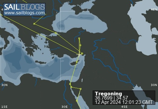
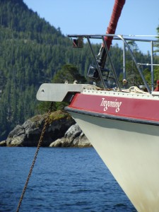
Tregoning
12 April 2024 | We are back aboard Tregoning in Mersin Marina, Mersin, Türkiye
02 April 2024 | We are in Toronto Airport, Canada: Tregoning is in Mersin Marina, Mersin, Türkiye
25 February 2024 | We are back in Gainesville, FL: Tregoning is in Mersin Marina, Mersin, Türkiye
18 February 2024 | We are in Glenwood, New Mexico: Tregoning is in Mersin Marina, Mersin, Türkiye
12 February 2024 | We are in Morro Bay, California: Tregoning is in Mersin Marina, Mersin, Türkiye
19 January 2024 | We are in Vancouver, BC Canada: Tregoning is in Mersin Marina, Mersin, Türkiye
01 January 2024 | We are in Washington State: Tregoning is in Mersin Marina, Mersin, Türkiye
15 December 2023 | We are in Minnesota: Tregoning is in Mersin Marina, Mersin, Türkiye
18 November 2023 | We are in Florida: Tregoning is in Mersin Marina, Mersin, Türkiye
29 October 2023 | We're in Florida - Tregoning is at B-dock, Mersin Marina, Mersin, Türkiye
21 October 2023 | 7 Oda Kapadokya Cave Hotel, Ürgüp, Türkiye
14 October 2023 | Hotel Aşikoğlu, Boğazkale, Türkiye
07 October 2023 | B-dock, Mersin Marina, Mersin, Türkiye
19 September 2023 | “Chez Jon & Angela”, Near Otterton, Devon, UK
14 September 2023 | Airbnb in Fortuneswell on the Isle of Portland, Dorset, UK
11 September 2023 | With Mike, Grange-over-Sands, Cumbria, UK
03 September 2023 | Ardington House, Ardington, Oxfordshire, UK
24 August 2023 | Near "Chez Joan and Peter", College of Roseisle, Moray, Scotland
11 August 2023 | Andrew's house (not exactly), Lichfield, UK
22 July 2023 | Chez Gail, near the New York Café, Budapest, Hungary
Did I mention the STAIRS?
11 April 2017 | Kaiaraara Bay, Port Fitzroy Harbour, Aotea, New Zealand
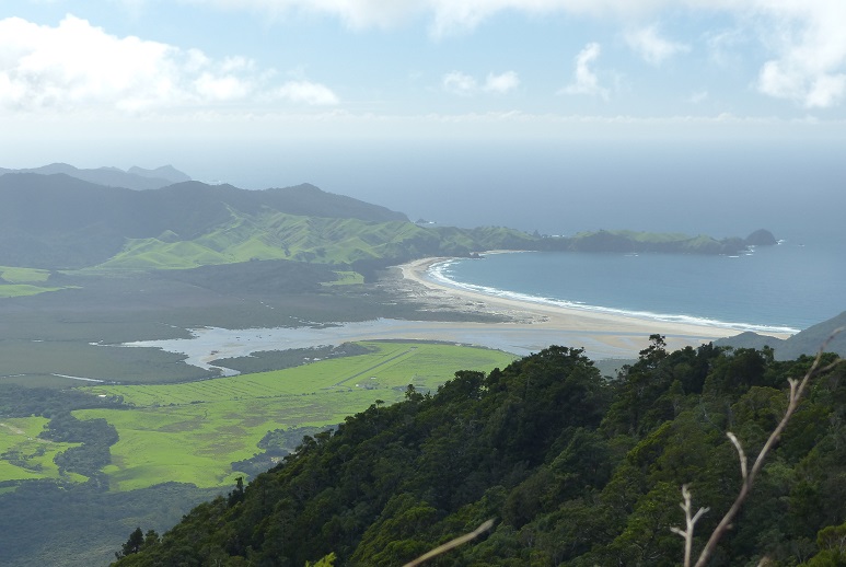
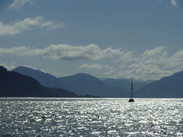
Photo: View while ascending Hirakimata; Tregoning is right of three boats in Kaiaraara Bay (center) with Motu Kaikoura and Little Barrier Island beyond
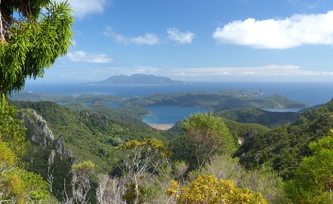
Satisfied with having explored most of the trails around Akapoua Bay and keen to attempt an ascent of Hirakimata (a.k.a. Mount Hobson), on Sunday (April 9th), we moved the short-distance to the next bay to the south, Kaiaraara Bay. We tried to anchor midway between the north and south shores but could not get the anchor to set securely so we moved towards the southern shore where several other boats were anchored, suggesting better holding.
Once we had happily set the anchor we noticed two boats that we recognized from Whangarei. Red Witch II (Robbie and Steph) was near the north shore and we had put ourselves right behind Astarté. We had not seen much of Barbara and Michael since our first summer in New Zealand but Michael kindly rode over in his dinghy to greet us. The next morning, they were planning to walk to Port Fitzroy Village while we were going to attempt to climb Hirakimata which at 627m (2,057 feet) is the highest point on the island and was clearly visible from the boat. We agreed to get together afterwards, or another day if we were too tired on our return.
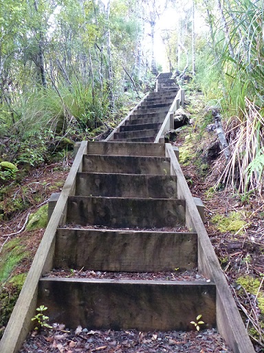
Is this the stairway to heaven?
The clouds over the mountains and rain on Sunday afternoon was rather discouraging but, happily for us, Monday dawned with fairly clear skies and sunshine, so we left the dinghy at Bush's Beach and followed the track to Kaiaraara Hut. Here we joined the Kaiaraara Track by crossing the first of seven or so swing bridges. Initially, we were walking upriver fairly close to the water but then we started climbing and met some STAIRS made from soil bound in wooden frames. I doubt that any other nation has the dedication to building stairs in steep and remote areas that the New Zealander's seem to show.
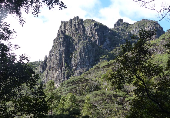
Cliffs to the south of the Kaiaraara Track reminded us of the Copper Canyon in Mexico
The valley was rapidly narrowing with impressive cliffs on the southern side from which we had to cross to continue on the marginally less sheer north side. This brought us to the first of two kauri dams on this stream and the need to walk down quite a few steps to get a good view and read the sign. It was worth the extra climb back up to the trail but all that was left of this dam were the large base logs jammed across the river.
Kauri logging started on Aotea in the 1790s when the crews of British ships felled the tall, straight trunks to make new masts. Trees near the coast were logged throughout the 19th and early 20th centuries, the most intensive harvesting being during the 1920s and 30s. Logs were extracted from the forest by horse- or bullock-drawn haulers, bush tramways, or down the small, nearby streams. Dams were built from kauri timbers to hold back huge amounts of water and kauri trunks. Once filled, a flume was opened towards the base of the dam releasing water and logs downsteam. Dams were tripped in succession, on the streams long enough to have more than one dam, driving the logs to the sea. There, the logs were collected in booms and then towed to Auckland for milling.
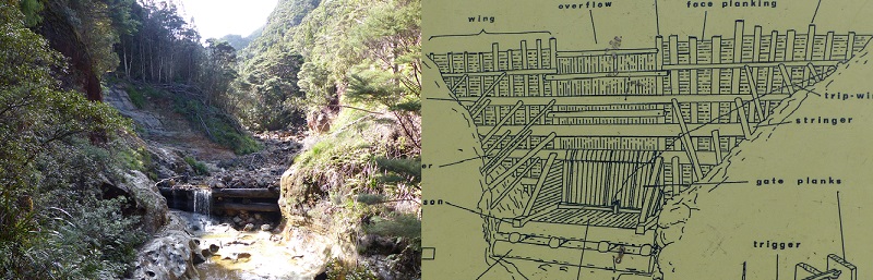
The foundation logs were all that remain of the kauri dam; a diagram of the full structure
The foundations that we were looking at were from a dam that had been built in 1927 and which had been one of the largest in the nation. The upper parts of the dam were strengthened in 1998 for conservation as an important heritage structure but, sadly, all but the bottom logs had been washed away in a terrible winter storm in June 2014, and there are no plans to rebuild it. This storm had dropped 44 cm (17 inches) of rain over three days, including a 4 hour period with 30.4 cm (12 inches), and caused numerous landslides on the island. The trail we were on had been closed for quite a while after the storm (in fact, one of our free maps indicated that it was still closed) until new paths could be established where the original track had been swept away. Some of these huge slide areas were sobering to see.
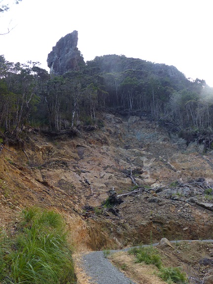
A new section of trail carved out of a major landslide from the June 2014 storm
As we approached the top of the valley, we started to see more and more kauri trees as we reached the remnants of the karuri forest that had never been logged. The track also became a continuous series of flights of wooden stairs going up steeply. We had not really appreciated from our views from the sea that the summit of Hirakimata is basically a tall rock pinnacle with vegetation clinging to the steep sides and no slopes suitable for winding tracks. The other reason for the long, long progression of STEEP STAIRS was that the top of the mountain was a nesting site for the endangered black petrels which make burrows under tree roots and other vegetation. Signs implored people to stay on the stairs and not scramble in the bush damaging nests.
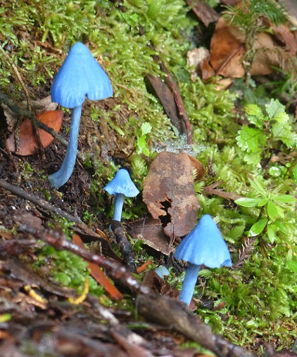
Did some Smurfs lose their umbrellas? Blue fungi on Hirakimata
We did not see any petrels even though it was not necessarily the end of nesting season but I did notice a burrow that looked freshly used and some bright blue mushrooms. The latter looked quite out of place, like something from a Smurfs' movie but they were scattered all over the mountain top although not in large groups. The wide diversity of fungal shapes, sizes and colors had been quite amazing all along the trail but being the autumn, this is presumably the prime time to find them. We also spotted a shrub with a daisy-like flower, which we think was the Great Barrier tree daisy, found only on this island.
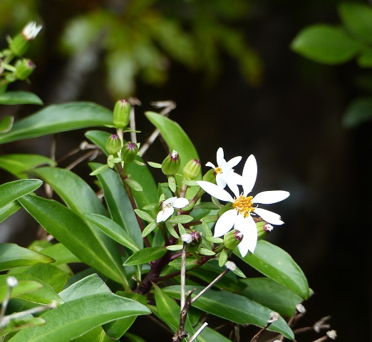
The Great Barrier tree daisy (I think)
We had met only one person on our whole four-hour ascent but when we finally reached the wooden summit platform, we joined another couple eating their lunch. Just a few minutes later a French family of seven arrived and got out their food, so it was quite the party on the summit. We all enjoyed the fabulous, almost 360 degree views over the island (just a little bit of the view to the east was blocked by vegetation but this kept us out of the wind). There is something very special about being on the highest and clear point on an island so that you can see down to the sea on all sides, including seeing Tregoning happily lying at anchor.
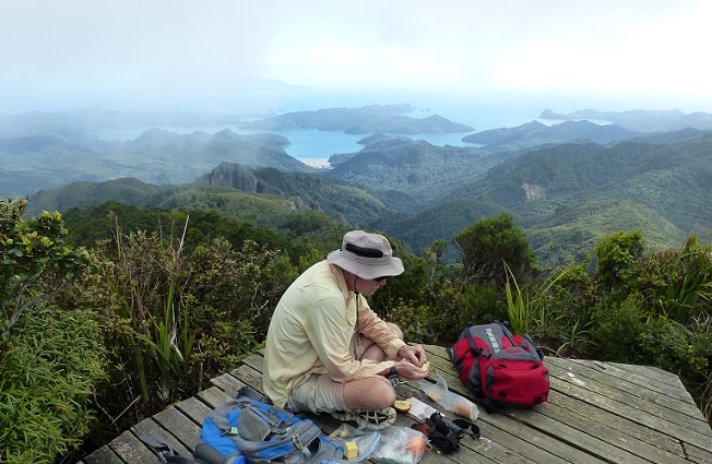
Randall dining on the summit platform
This was especially thrilling for us because we have actually seen very little of Aotea outside Fitzroy Harbour and we were impressed by the two huge arcs of sandy beach on the east coast, to the north and south of us. During our ascent, we had enjoyed breathtaking views of Little Barrier Island as it appeared over the rapidly diminishing Motu Kaikoura and from the summit we could clearly see the Hen and Chickens Islands far beyond it. With binoculars, we could even see the Whangarei Heads beyond the Hen and Chickens, a good 43 nm away.
Okiwi airfield and Whangapoua Beach as seen from Hirakimata summit
Randall had set the pace for our final ascent of the STEEP, STEEP STAIRS at a stately speed with many, short stops but this had paid-off and he felt remarkably energetic once he had devoured a large handful of crackers with peanut-butter and jelly. Thus, we both decided to continue on the loop-walk following the South Fork Track down the next valley to the south. It was a longer route than the Kaiaraara Track (essentially covering the other two sides of a triangle) but the contours on the map promised that part of it was a gradually descending ridge walk.
This was indeed true but only after descending MANY STEEP STAIRS off Hirakimata's summit. This route took us along the side of the naked pinnacle of Mount Heale and past a Department of Conservation Hut there. We had a quick look inside (with the permission of, but rather to the surprise of, two young hikers who had spread-out all of their stuff expecting to be the only people there) and were impressed with the neat kitchen (gas stove provided), bunk beds (supposedly sleeps up to 20) and the stunning view from the balcony.
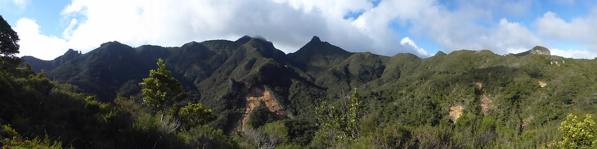
Landslip areas scar the forest; looking from the South Fork Track ridge northeast to Hurakimata (just in cloud) and, to its right, the pinnacle of Mt Heale
The gradual ridge walk was delightful with spectacular views back up to Hirakimata (starting to be shrouded in clouds so we were incredibly lucky to have clear views when up there) and south to the cliffs of the razor-topped Hogs Back Mountain. Although much of this area would have been logged for kauri trees, there were plenty of signs of regeneration of the kauri forest with some fairly large trees. At the end of our ridge, we paid for the previously gradual descent with a steep section on a narrow trail that was mostly bare earth, made slick by recent rain. I, in my hiking boots, trod carefully but pretty confidently while Randall, in his rather worn tennis shoes, deeply regretted forgetting to bring his walking stick with him. Still, we got down without mishap and looked forward to the last, easy part of the loop-trail back along an old forest road to the Kaiaraara Hut. Or so we thought.
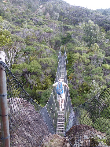
Randall on a bridge posted for just one person at a time on the South Fork Track
Before getting to the forest road, however, we reached the South Fork of the Kaiaraara Stream which we had to cross by picking out natural stepping stones (any deliberately placed ones had apparently been washed away). I thought that the DoC warning sign that suggested "After heavy rain, proceed with caution" was a bit of an understatement for this crossing. On the other side of the stream bed, there was no sign of a trail heading up the stream bank but there were tall, fluorescent pink stakes further downstream. So we started following these poles, zig-zagging back and forth across the stream on whatever emergent stones we could find. We had far enough to go that giving-up on the stones and getting our shoes wet was not particularly tempting.
Perplexed, I studied the sticker on our Track map which said "1st Stream crossing from Kaiaraara end, walk 500 meters up stream and follow the orange marker pegs". Since we were doing this in the opposite direction and we had not crossed the stream before (except much earlier on an exceptionally narrow, one-person swing bridge), it was not obvious that this note applied to us yet (why say first crossing if this was the only one?). However, it finally dawned on me that where I had assumed that it meant that the stream crossing had been moved 500 meters upstream (with no space between 'up' and 'stream') but you continued to the new crossing on a trail, it actually meant, continue 500 meters up the stream bed. So we had to make our way along the stream bed, crossing back and forth about ten times, when the bank was too steep on one side, and in places finding few suitable stepping stones. I scouted ahead until I found the trail arrows pointing up the stream bank while Randall coped by picking-up two branches for river-crossing sticks. It would have been more fun if it had not delayed us by at least half-an-hour and made us wonder if we would get back to the dinghy before dark.
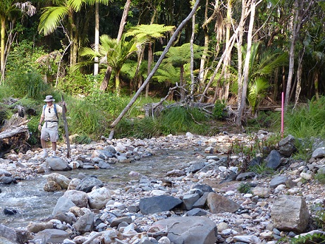
Randall and one of his stone-hopping sticks walking down the stream bed opposite a pink marker pole
Luckily, once we reached the forest road, there were much easier walking conditions all the way back to the beach so that we arrived around 5:30 pm, just before the sun set over Motu Kaikoura. At the beach, we found the dinghy we recognized from Red Witch II so we left them a note and planned to see them the next day. After our 8.5-hour expedition, we knew that once we returned to Tregoning, there would be no getting off her again for the evening. Although the actual distance covered may have been only about 14 km (just under 9 miles) and the peak was not particularly high (although we did start from actual sea level), the real challenge was, in case I did not make it clear, all of the MANY, STEEP STAIRS. We agreed with the map description that said that "You'll need to be fit."
Once we had happily set the anchor we noticed two boats that we recognized from Whangarei. Red Witch II (Robbie and Steph) was near the north shore and we had put ourselves right behind Astarté. We had not seen much of Barbara and Michael since our first summer in New Zealand but Michael kindly rode over in his dinghy to greet us. The next morning, they were planning to walk to Port Fitzroy Village while we were going to attempt to climb Hirakimata which at 627m (2,057 feet) is the highest point on the island and was clearly visible from the boat. We agreed to get together afterwards, or another day if we were too tired on our return.
Is this the stairway to heaven?
The clouds over the mountains and rain on Sunday afternoon was rather discouraging but, happily for us, Monday dawned with fairly clear skies and sunshine, so we left the dinghy at Bush's Beach and followed the track to Kaiaraara Hut. Here we joined the Kaiaraara Track by crossing the first of seven or so swing bridges. Initially, we were walking upriver fairly close to the water but then we started climbing and met some STAIRS made from soil bound in wooden frames. I doubt that any other nation has the dedication to building stairs in steep and remote areas that the New Zealander's seem to show.
Cliffs to the south of the Kaiaraara Track reminded us of the Copper Canyon in Mexico
The valley was rapidly narrowing with impressive cliffs on the southern side from which we had to cross to continue on the marginally less sheer north side. This brought us to the first of two kauri dams on this stream and the need to walk down quite a few steps to get a good view and read the sign. It was worth the extra climb back up to the trail but all that was left of this dam were the large base logs jammed across the river.
Kauri logging started on Aotea in the 1790s when the crews of British ships felled the tall, straight trunks to make new masts. Trees near the coast were logged throughout the 19th and early 20th centuries, the most intensive harvesting being during the 1920s and 30s. Logs were extracted from the forest by horse- or bullock-drawn haulers, bush tramways, or down the small, nearby streams. Dams were built from kauri timbers to hold back huge amounts of water and kauri trunks. Once filled, a flume was opened towards the base of the dam releasing water and logs downsteam. Dams were tripped in succession, on the streams long enough to have more than one dam, driving the logs to the sea. There, the logs were collected in booms and then towed to Auckland for milling.
The foundation logs were all that remain of the kauri dam; a diagram of the full structure
The foundations that we were looking at were from a dam that had been built in 1927 and which had been one of the largest in the nation. The upper parts of the dam were strengthened in 1998 for conservation as an important heritage structure but, sadly, all but the bottom logs had been washed away in a terrible winter storm in June 2014, and there are no plans to rebuild it. This storm had dropped 44 cm (17 inches) of rain over three days, including a 4 hour period with 30.4 cm (12 inches), and caused numerous landslides on the island. The trail we were on had been closed for quite a while after the storm (in fact, one of our free maps indicated that it was still closed) until new paths could be established where the original track had been swept away. Some of these huge slide areas were sobering to see.
A new section of trail carved out of a major landslide from the June 2014 storm
As we approached the top of the valley, we started to see more and more kauri trees as we reached the remnants of the karuri forest that had never been logged. The track also became a continuous series of flights of wooden stairs going up steeply. We had not really appreciated from our views from the sea that the summit of Hirakimata is basically a tall rock pinnacle with vegetation clinging to the steep sides and no slopes suitable for winding tracks. The other reason for the long, long progression of STEEP STAIRS was that the top of the mountain was a nesting site for the endangered black petrels which make burrows under tree roots and other vegetation. Signs implored people to stay on the stairs and not scramble in the bush damaging nests.
Did some Smurfs lose their umbrellas? Blue fungi on Hirakimata
We did not see any petrels even though it was not necessarily the end of nesting season but I did notice a burrow that looked freshly used and some bright blue mushrooms. The latter looked quite out of place, like something from a Smurfs' movie but they were scattered all over the mountain top although not in large groups. The wide diversity of fungal shapes, sizes and colors had been quite amazing all along the trail but being the autumn, this is presumably the prime time to find them. We also spotted a shrub with a daisy-like flower, which we think was the Great Barrier tree daisy, found only on this island.
The Great Barrier tree daisy (I think)
We had met only one person on our whole four-hour ascent but when we finally reached the wooden summit platform, we joined another couple eating their lunch. Just a few minutes later a French family of seven arrived and got out their food, so it was quite the party on the summit. We all enjoyed the fabulous, almost 360 degree views over the island (just a little bit of the view to the east was blocked by vegetation but this kept us out of the wind). There is something very special about being on the highest and clear point on an island so that you can see down to the sea on all sides, including seeing Tregoning happily lying at anchor.
Randall dining on the summit platform
This was especially thrilling for us because we have actually seen very little of Aotea outside Fitzroy Harbour and we were impressed by the two huge arcs of sandy beach on the east coast, to the north and south of us. During our ascent, we had enjoyed breathtaking views of Little Barrier Island as it appeared over the rapidly diminishing Motu Kaikoura and from the summit we could clearly see the Hen and Chickens Islands far beyond it. With binoculars, we could even see the Whangarei Heads beyond the Hen and Chickens, a good 43 nm away.
Okiwi airfield and Whangapoua Beach as seen from Hirakimata summit
Randall had set the pace for our final ascent of the STEEP, STEEP STAIRS at a stately speed with many, short stops but this had paid-off and he felt remarkably energetic once he had devoured a large handful of crackers with peanut-butter and jelly. Thus, we both decided to continue on the loop-walk following the South Fork Track down the next valley to the south. It was a longer route than the Kaiaraara Track (essentially covering the other two sides of a triangle) but the contours on the map promised that part of it was a gradually descending ridge walk.
This was indeed true but only after descending MANY STEEP STAIRS off Hirakimata's summit. This route took us along the side of the naked pinnacle of Mount Heale and past a Department of Conservation Hut there. We had a quick look inside (with the permission of, but rather to the surprise of, two young hikers who had spread-out all of their stuff expecting to be the only people there) and were impressed with the neat kitchen (gas stove provided), bunk beds (supposedly sleeps up to 20) and the stunning view from the balcony.
Landslip areas scar the forest; looking from the South Fork Track ridge northeast to Hurakimata (just in cloud) and, to its right, the pinnacle of Mt Heale
The gradual ridge walk was delightful with spectacular views back up to Hirakimata (starting to be shrouded in clouds so we were incredibly lucky to have clear views when up there) and south to the cliffs of the razor-topped Hogs Back Mountain. Although much of this area would have been logged for kauri trees, there were plenty of signs of regeneration of the kauri forest with some fairly large trees. At the end of our ridge, we paid for the previously gradual descent with a steep section on a narrow trail that was mostly bare earth, made slick by recent rain. I, in my hiking boots, trod carefully but pretty confidently while Randall, in his rather worn tennis shoes, deeply regretted forgetting to bring his walking stick with him. Still, we got down without mishap and looked forward to the last, easy part of the loop-trail back along an old forest road to the Kaiaraara Hut. Or so we thought.
Randall on a bridge posted for just one person at a time on the South Fork Track
Before getting to the forest road, however, we reached the South Fork of the Kaiaraara Stream which we had to cross by picking out natural stepping stones (any deliberately placed ones had apparently been washed away). I thought that the DoC warning sign that suggested "After heavy rain, proceed with caution" was a bit of an understatement for this crossing. On the other side of the stream bed, there was no sign of a trail heading up the stream bank but there were tall, fluorescent pink stakes further downstream. So we started following these poles, zig-zagging back and forth across the stream on whatever emergent stones we could find. We had far enough to go that giving-up on the stones and getting our shoes wet was not particularly tempting.
Perplexed, I studied the sticker on our Track map which said "1st Stream crossing from Kaiaraara end, walk 500 meters up stream and follow the orange marker pegs". Since we were doing this in the opposite direction and we had not crossed the stream before (except much earlier on an exceptionally narrow, one-person swing bridge), it was not obvious that this note applied to us yet (why say first crossing if this was the only one?). However, it finally dawned on me that where I had assumed that it meant that the stream crossing had been moved 500 meters upstream (with no space between 'up' and 'stream') but you continued to the new crossing on a trail, it actually meant, continue 500 meters up the stream bed. So we had to make our way along the stream bed, crossing back and forth about ten times, when the bank was too steep on one side, and in places finding few suitable stepping stones. I scouted ahead until I found the trail arrows pointing up the stream bank while Randall coped by picking-up two branches for river-crossing sticks. It would have been more fun if it had not delayed us by at least half-an-hour and made us wonder if we would get back to the dinghy before dark.
Randall and one of his stone-hopping sticks walking down the stream bed opposite a pink marker pole
Luckily, once we reached the forest road, there were much easier walking conditions all the way back to the beach so that we arrived around 5:30 pm, just before the sun set over Motu Kaikoura. At the beach, we found the dinghy we recognized from Red Witch II so we left them a note and planned to see them the next day. After our 8.5-hour expedition, we knew that once we returned to Tregoning, there would be no getting off her again for the evening. Although the actual distance covered may have been only about 14 km (just under 9 miles) and the peak was not particularly high (although we did start from actual sea level), the real challenge was, in case I did not make it clear, all of the MANY, STEEP STAIRS. We agreed with the map description that said that "You'll need to be fit."
Comments
| Vessel Name: | Tregoning |
| Vessel Make/Model: | Morgan Classic 41 |
| Hailing Port: | Gainesville, FL |
| Crew: | Alison and Randall |
| About: | We cast-off from Fernandina Beach in north Florida on 1st June 2008 and we have been cruising on Tregoning ever since. Before buying Tregoning, both of us had been sailing on smaller boats for many years and had worked around boats and water throughout our careers. |
| Extra: | “Tregoning” (rhymes with “belonging”) and is a Cornish word (meaning “homestead of Cohnan” or “farm by the ash trees”) and was Alison's mother’s middle name. Cornwall is in southwest England and is where Alison grew-up. |
Tregoning's Photos - Main
 |
 |
 |
 |
 |
 |
 |
 |
 |
 |
 |
The Sailblogs Prequel: Adding old posts from expired blog
166 Photos
Created 26 May 2020
|
 |
 |
 |
 |
 |
 |
 |
 |
 |
 |
 |
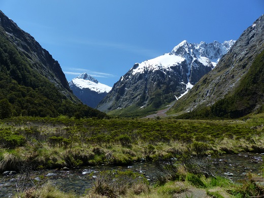 |
Extra photographs from our three-week campervan tour of the South Island from November 15th to December 5th 2015
217 Photos
Created 4 January 2016
|
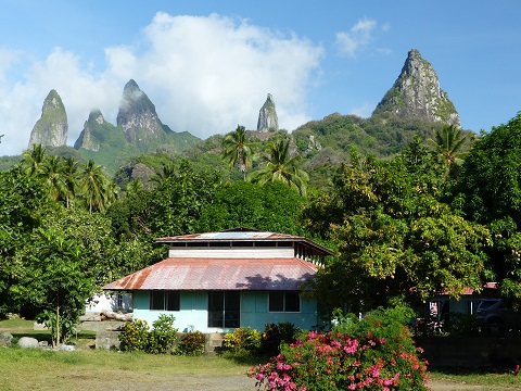 |
Random pictures from our month spent on the islands of Hiva Oa, Tahuata, Ua Pou, and Nuku Hiva
45 Photos
Created 18 July 2015
|
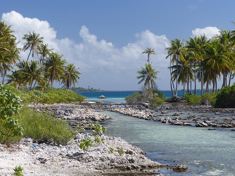 |
Random pictures from our month spent in 4 Tuamotu Atolls; Ahe, Fakarava, Tahanea, and Toau
32 Photos
Created 1 July 2015
|
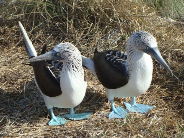 |
Some of the birds, fish, reptiles, and mammals (and others) that we have seen in Mexico
74 Photos
Created 5 May 2014
|
 |
Tregoning
Who: Alison and Randall
Port: Gainesville, FL
Gallery