s/v Tropical Spice
26 November 2008 | Cocoa Village, FL
11 November 2008 | Sunny, few cirrus clouds, breezy, cool
06 November 2008 | Town Creek Marina
04 November 2008 | Town Creek Marina, Beaufort NC
14 October 2008 | Kill Devil Hills, North Carolina
17 March 2008 | Taken by his breeder in Sarasota, FL designed to entice Peggy to fall head over heels in love with him so she would drive from NC to FL and back again with him. Which she did.
16 March 2008 | or
10:30 AM Church Creek to Beaufort, SC
11 November 2008 | Sunny, few cirrus clouds, breezy, cool
The smell of grilled cheese and ham sandwiches wafts up the companionway from the galley. The Captain is hungry and cold, the dog still asleep on his full tummy.
Just passed marker 197.
We have been snaking our way, twisting and turning running sometimes with the current at a speed of 9 knots. Sometimes against the current at 5 knots.
In this stretch the edges of the ICW are marsh on both sides. Our heading is presently SW with a turn to the W coming in a few moments.
The live oak trees are interspersed with with South Carolina's state tree, the White Palmetto.
I love their state flag.
The state flag of South Carolina was officially adopted in 1861. It has a white crescent and a white palmetto tree on a blue ground. Three white crescents (on a blue background) were first used on a South Carolina banner protesting the Stamp Act in 1765. In 1775, Colonel William Moultrie designed a banner for South Carolina troops; it had a white crescent on a blue field. When South Carolina seceded from the Union, the palmetto tree was added to the flag. The palmetto tree was chosen because this tree had helped South Carolinians defeat the British in a battle at Sullivan's Island (during the Revolutionary War). The South Carolinians built a fort out of palmetto wood, and when the British fired cannonballs at the fort, instead of knocking the fort down, the soft palmetto wood just absorbed the cannonballs.
Occasionally one sees houses across land we are passing. Range markers prevail and we notice that lining them up agrees exactly with the magenta line on our radar. Good Show.
The depth sounder sounds it's warning. The channel is narrow here.
The chart showed 15' but the depth sounder indicates 7.3. Even with our extra 2 feet the shoaling is evident.
The Captain quips that it is obviously cheaper to add range markers than dredge.
Finally, 10 to 14 feet of water...one can relax.
I am sitting in the cockpit in layered clothing. Sweat pants and rain/wind pants, shoes, socks, heavy Irish sweater and West Marine offshore foul weather jacket.
I love looking at the shore line, both with binoculars and the camera zoom.
The marsh grass is tipped in golden brown, followed by a light green band, a marsh (wake and tide) grey mud area, back to green again. On top of the mud there is a gray thatch area, then rich black mud. It is sometimes layered with a shell layer - spoil perhaps.
At he shore line there is an abundance of open clam, mussel and oyster shells exposed by the tide and devoured by heron, egrets and seagulls.
Huge vacant osprey nests fill tree tops, summer occupancy only.
Marker 184 and the long anticipated dredges appear narrowing an already narrow channel. These are suppose to be the answer to the Captain's prayer. However, a north bound sailboat at the entrance of the channel coming in from St. Helena Sound with more than plenty of space to negotiate in pushes his way into the channel between Tropical Spice and the barge forcing us up onto the pluff mud bank. We are aground.
The smaller sailboat continues north and we rock ourselves off going back and forth.
Finally, open water. St. Helena Sound.
Comments
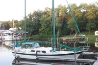
| Vessel Name: | Tropical Spice |
| Vessel Make/Model: | Wellington 44 built in 1981 in Jacksonville, FL |
| Hailing Port: | Colington Harbour, Kill Devil Hills, North Carolina |
| Crew: | Dave, Peggy & Bo our Portuguese Water Dog. |
| About: | |
| Extra: | http://ssca.org/cgi-bin/pagegen.pl?pg=home&title=Home |
| Home Page: | /member/tropicalspice |
Gallery not available
S/V TROPICAL SPICE
Who: Dave, Peggy & Bo our Portuguese Water Dog.
Port: Colington Harbour, Kill Devil Hills, North Carolina