
28 December 2010
10 October 2010
10 October 2010 | Niue
10 October 2010 | Nowhereland
10 October 2010 | Cook Islands
22 September 2010 | Rarotonga, Cook Islands
04 September 2010 | Rarotonga
22 August 2010
29 July 2010 | Tuamotus
10 July 2010 | Nuku Hiva
04 May 2010 | Oahu for one more day
Beveridge Reef
10 October 2010 | Nowhereland
Kevin

Beveridge Reef
After leaving Palmerston, we set a course for Beveridge Reef, 230 miles to the southwest. The frontal system that had kept winds above 30 knots for most of the previous week was not going anywhere, so we poled out about 50% of the genoa and flew downwind. We had heard about Beveridge Reef from a couple of other cruisers back in Papeete who recommended it as an awesome place to stop over between the Cooks and Niue. I looked for it on our electronic charts, but all it showed was a big green blotch (the color of dry reef) and made some vague comment as to the inaccuracy of the location and soundings. Before leaving Rarotonga, I had downloaded a hand-drawn chart of the reef itself from the internet. This chart at least showed the horseshoe shape of the reef, the pass on the western side, and the lagoon. But, strangely enough, the coordinates on the hand-drawn chart were close to a mile off the coordinates on our E-charts. We had expected this, as often remote reefs and islands like this are relying on bathymetric surveys from the 1800's (I kid you not, some of our paper charts for the Marquesas were from an 1882 survey). So, we just knew we'd have to find the reef the old fashioned way- arrive in the vicinity during daylight hours, and just watch like a hawk for the darned thing so we wouldn't run into it. We tend to do this anyway, even with well-charted places. The captain who ends up on the rocks is the one who trusts everything to his charts or any single source of information.
So, we planned our passage to arrive in the vicinity of Beveridge the morning of the third day at sea. When that morning arrived, and we neared the supposed location, we just kept watch for any sign of breakers, discolored clouds (green above the lagoon) or whatever. Sure enough, we saw breakers ahead, and as we rounded the southern side of the reef, plotted the actual position of the reef to be nearly 2 miles away from either of our charted locations. Go figure. Imagine trying to sail past the thing in the middle of the night, thinking you're giving it a two mile leeway, when BAM! It has definitely happened, as the fairly recent wreck of a longline fishing boat on the eastern side of the reef can attest to. When we entered the lagoon and swung up into the wind, we were blasted in the face by the force of the wind we'd been running with the whole time. It made us glad we hadn't been trying to beat into it! There were no other boats there. We motored dead upwind across the lagoon about a mile to the eastern side, and anchored a quarter mile from the wreck just off the edge of the sand margin in about 30 feet of water. This was where it transitioned from 6ft reef flat depths to the deeper (30ft) lagoon. We dropped the hook in 8 feet, with Shannon's keel just above the bottom, then drifted back over deeper water. Even the short fetch between the reef and the boat was kicking up pretty significant chop that occasionally found its way on deck. As it was, all the chop was right on the nose, so it was comfortable enough down below. The place is called Beveridge Reef, and even though it is not spelled quite the same, warranted a round of beverages for the crew. We sat up on deck in the brilliant sunshine and blasting wind and took a self-timed picture of the four of us on the bow with our beverages. It was so windy the camera kept blowing over.
We felt it was a little unsafe to go anywhere in the dinghy due to the high winds and our puny and occasionally less-than-reliable outboard (if it died, we'd be blown all the way across the lagoon and probably out the other side very quickly). So, we decided to take our exercise, and swim over to the longline wreck. When I jumped in the water I realized the incredibly good visibility of the place. With no land to cause sediment runoff, the water was super clear, despite the wind. On our way to the wreck we saw lots of stingrays, and a strange migration of thousands of nudibranchs, all crawling along in huge trains to no obvious destination.. The wreck was , well, a wreck, with the usual broken dishes, soggy matresses, empty engine room, and huge scar in the reef. We played around on it for a while, watching all the blacktip reef sharks swim around it in the shallow water with their dorsal fins out of the water . There was a whole school of Parrotfish lounging in a shallow spot next to the wreck, availing themselves of a thin stream of cool water coming in over the reef from the rising tide. Their tails and dorsal fins were out of the water too- something I'd never seen parrotfish do.
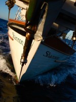
When we returned to the boat, I couldn't help but take advantage of the awesome visibility to take some photos of Shannon from below.
Because of the conditions, we decided we had seen most of what we could, and departed the next morning. Just prior to our departure, I realized that our power inverter had crapped out on us. Yes, the new one we had bought so recently in Tahiti. Well, it just refused to work, and so did our old one. What that means is that there's no way to charge the computer to run our chartplotting program. Ok, I thought, We'll just turn on the computer from time to time and do spot-checks of our position, and if we do that, the laptop battery should be able to last a few days, long enough to get the 130 miles to Niue. Well, the computer battery was stone cold dead. Hmmm. So, we broke out the backup computer. Its battery was also stone cold dead. A secret smile spread across my face as I realized that yes, technology had failed us and we would have to revert back to more traditional methods. So, we poured through our rolls of paper charts, looking for a chart of the vicinity. Well, I can tell you we have just about every other corner of the entire pacific covered, but not the no-man's land between the Cook Islands and Niue. I found one chart that covered the larger western pacific, but the exact area we needed to consult was covered by a map legend. Ha! So, with no other options, we consulted our sailing directions to at least assure there were no other uncharted reefs in our path to Niue, and busted out the plotting sheets to hand-draw our own chart. So, off we set thus, recording DR positions every hour in the log, and plotting our position from the backup handheld gps every so often. All the while I was secretly hoping that the backup gps would fail, requiring the sextant to be broken out and a noonsite to be taken the next day. Alas, it was not to be so, and we sailed into Niue a day and a half later under GPS and jury-rigged chart.
After leaving Palmerston, we set a course for Beveridge Reef, 230 miles to the southwest. The frontal system that had kept winds above 30 knots for most of the previous week was not going anywhere, so we poled out about 50% of the genoa and flew downwind. We had heard about Beveridge Reef from a couple of other cruisers back in Papeete who recommended it as an awesome place to stop over between the Cooks and Niue. I looked for it on our electronic charts, but all it showed was a big green blotch (the color of dry reef) and made some vague comment as to the inaccuracy of the location and soundings. Before leaving Rarotonga, I had downloaded a hand-drawn chart of the reef itself from the internet. This chart at least showed the horseshoe shape of the reef, the pass on the western side, and the lagoon. But, strangely enough, the coordinates on the hand-drawn chart were close to a mile off the coordinates on our E-charts. We had expected this, as often remote reefs and islands like this are relying on bathymetric surveys from the 1800's (I kid you not, some of our paper charts for the Marquesas were from an 1882 survey). So, we just knew we'd have to find the reef the old fashioned way- arrive in the vicinity during daylight hours, and just watch like a hawk for the darned thing so we wouldn't run into it. We tend to do this anyway, even with well-charted places. The captain who ends up on the rocks is the one who trusts everything to his charts or any single source of information.
So, we planned our passage to arrive in the vicinity of Beveridge the morning of the third day at sea. When that morning arrived, and we neared the supposed location, we just kept watch for any sign of breakers, discolored clouds (green above the lagoon) or whatever. Sure enough, we saw breakers ahead, and as we rounded the southern side of the reef, plotted the actual position of the reef to be nearly 2 miles away from either of our charted locations. Go figure. Imagine trying to sail past the thing in the middle of the night, thinking you're giving it a two mile leeway, when BAM! It has definitely happened, as the fairly recent wreck of a longline fishing boat on the eastern side of the reef can attest to. When we entered the lagoon and swung up into the wind, we were blasted in the face by the force of the wind we'd been running with the whole time. It made us glad we hadn't been trying to beat into it! There were no other boats there. We motored dead upwind across the lagoon about a mile to the eastern side, and anchored a quarter mile from the wreck just off the edge of the sand margin in about 30 feet of water. This was where it transitioned from 6ft reef flat depths to the deeper (30ft) lagoon. We dropped the hook in 8 feet, with Shannon's keel just above the bottom, then drifted back over deeper water. Even the short fetch between the reef and the boat was kicking up pretty significant chop that occasionally found its way on deck. As it was, all the chop was right on the nose, so it was comfortable enough down below. The place is called Beveridge Reef, and even though it is not spelled quite the same, warranted a round of beverages for the crew. We sat up on deck in the brilliant sunshine and blasting wind and took a self-timed picture of the four of us on the bow with our beverages. It was so windy the camera kept blowing over.
We felt it was a little unsafe to go anywhere in the dinghy due to the high winds and our puny and occasionally less-than-reliable outboard (if it died, we'd be blown all the way across the lagoon and probably out the other side very quickly). So, we decided to take our exercise, and swim over to the longline wreck. When I jumped in the water I realized the incredibly good visibility of the place. With no land to cause sediment runoff, the water was super clear, despite the wind. On our way to the wreck we saw lots of stingrays, and a strange migration of thousands of nudibranchs, all crawling along in huge trains to no obvious destination.. The wreck was , well, a wreck, with the usual broken dishes, soggy matresses, empty engine room, and huge scar in the reef. We played around on it for a while, watching all the blacktip reef sharks swim around it in the shallow water with their dorsal fins out of the water . There was a whole school of Parrotfish lounging in a shallow spot next to the wreck, availing themselves of a thin stream of cool water coming in over the reef from the rising tide. Their tails and dorsal fins were out of the water too- something I'd never seen parrotfish do.
When we returned to the boat, I couldn't help but take advantage of the awesome visibility to take some photos of Shannon from below.
Because of the conditions, we decided we had seen most of what we could, and departed the next morning. Just prior to our departure, I realized that our power inverter had crapped out on us. Yes, the new one we had bought so recently in Tahiti. Well, it just refused to work, and so did our old one. What that means is that there's no way to charge the computer to run our chartplotting program. Ok, I thought, We'll just turn on the computer from time to time and do spot-checks of our position, and if we do that, the laptop battery should be able to last a few days, long enough to get the 130 miles to Niue. Well, the computer battery was stone cold dead. Hmmm. So, we broke out the backup computer. Its battery was also stone cold dead. A secret smile spread across my face as I realized that yes, technology had failed us and we would have to revert back to more traditional methods. So, we poured through our rolls of paper charts, looking for a chart of the vicinity. Well, I can tell you we have just about every other corner of the entire pacific covered, but not the no-man's land between the Cook Islands and Niue. I found one chart that covered the larger western pacific, but the exact area we needed to consult was covered by a map legend. Ha! So, with no other options, we consulted our sailing directions to at least assure there were no other uncharted reefs in our path to Niue, and busted out the plotting sheets to hand-draw our own chart. So, off we set thus, recording DR positions every hour in the log, and plotting our position from the backup handheld gps every so often. All the while I was secretly hoping that the backup gps would fail, requiring the sextant to be broken out and a noonsite to be taken the next day. Alas, it was not to be so, and we sailed into Niue a day and a half later under GPS and jury-rigged chart.
Comments
| Vessel Name: | Shannon |
| Vessel Make/Model: | Union 36 |
| Hailing Port: | Kailua, Hawaii |
| Crew: | Kevin O'Brien, Christina Hoe, Ken Bwy, Alina Madadi Bwy, Britton Warfield |
Gallery not available
Crew of the Shannon
Who: Kevin O'Brien, Christina Hoe, Ken Bwy, Alina Madadi Bwy, Britton Warfield
Port: Kailua, Hawaii