
Zen - family cruising catamaran
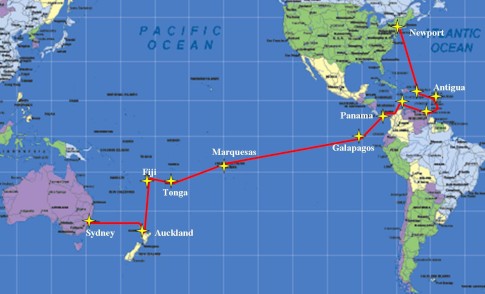
Family of 4 sailing from New England to Auckland, New Zealand '08-'10


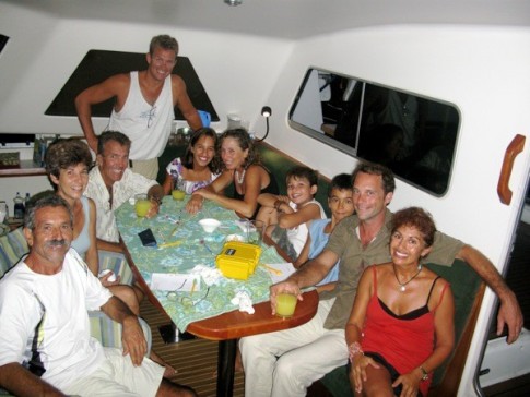
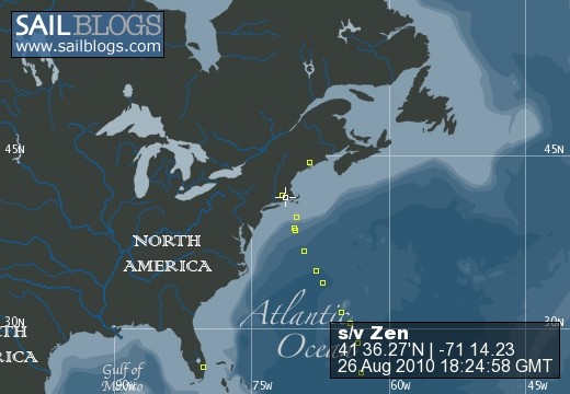
26 August 2010 | Portsmouth, Rhode Island
27 April 2010 | Rhode Island
05 April 2010 | Fort Lauderdale, FL
24 March 2010 | Portsmouth, RI
19 February 2010 | middle of Pacific Ocean
12 February 2010 | Waiheke Island, NZ
08 February 2010 | Auckland, New Zealand
30 January 2010 | Whangarei, New Zealand
26 January 2010 | Whangarei, New Zealand
22 January 2010 | Whangarei, New Zealand
20 January 2010 | Whangarei, New Zealand
17 January 2010 | Whangarei, New Zealand
14 January 2010 | Whangarei, New Zealand
08 January 2010 | Los Angeles, CA
07 January 2010 | Newark International Airport
27 December 2009 | Rhode Island, USA
10 December 2009 | New Delhi, India
02 December 2009 | South Island, NZ
13 November 2009 | Whangarei, New Zealand
10 November 2009 | Opua and Kerikeri, New Zealand
Cruising Info for Entering and Anchoring in Aitutaki, Cook Islands
09 July 2009 | Aitutaki, Cook Islands
Tom

My first suggestion on the Arutanga pass/anchorage(s) is to take a look at Aitutaki on Google Earth. I found it very helpful but obviously it is not critical. I will avoid waypoints because it is mostly eyeball navigation, my paper charts were plotted many moons ago and my Nobeltec electronic charts are not accurate for Aitutaki. The entrance to the pass is not marked but was generally close to the lat/lon on my electronic charts. It is especially important for the Arutanga pass to try and time your approach with a high mid day or afternoon sun...sun in the Western sky...so you can clearly see the entrance and bottom of the pass. When you get close you will see (eyeball) the break in the reef where the pass begins. You may also see some noticeable wave action caused by the continuous out flowing current. Another feature to look for is the row of metal (re-bar) markers that line the pass into the harbor. The re-bar leads right to the opening from the inside of the pass (sorry if that was obvious :). You will keep these markers to your left while inbound transiting the pass. The pass carries a width of approx 40 feet to the harbor and the shallowest point we recorded was 6.1 feet about half to two/thirds way down the pass. Another marker for the shallow spot is a wrecked and rusted barge set back about 30 yards to the left (while heading in) of the pass. The shallow spot is soft sand and about 15 to 25 yards long. Once inside the pass you have a choice of three small anchorage locations. You will be traveling South-East down the pass. As you near the harbor you will reach a point where you have three directional choices (this is very obvious on Google Earth). For the purpose of this description I will call this point the "intersection". If you do not have a chance to look at Google this spot is approximately 100 yards before the actual entrance of the main harbor. If you have good water clarity you will see the coral heads to your right and the opening to the pond (I describe the pond in more detail below) on your left. From the intersection the first choice is to continue straight into the main harbor, the second is to veer right (South) before the coral heads and head down the passage toward the lagoon and the third is to veer left (East) into a small "pond" just north of the main town quay. If you draw more than 4 feet the entrance to the pond may be too shallow. Now more detail on the three anchorage choices. 1. If you continue straight into the harbor you have a couple anchoring choices. In both cases you need to stay clear of the main town quay and anchor on the South part of the harbor. You can either anchor in the middle of the Southern portion with a bow and stern anchor or you can put out one anchor and tie a line to a tree on shore. The main harbor is reportedly clear of coral heads but there are a few shallow spots so go slow. 2. The second option is to veer right (South) at the intersection, heading down the lagoon pass. You can anchor anywhere between the intersection (the point in the pass that breaks into three directions) and a re-bar/metal marker approx 250 to 300 yards down this section of the pass towards the lagoon. You must also use a bow and stern anchor in this area. As you enter this area you will have a very shallow coral reef to your left (East) and very shallow mostly sand bottom to your right (West). We anchored in this spot the first night along with three other boats. We were all parallel parked with our bows facing SE. There is a constant out flowing current in this area (2 to 4 kts depending on the tide). You MUST have your stern anchor ready to go before you drop the bow anchor. If you plan to use your dinghy to set the stern anchor then have that ready too. The current makes it a bit tricky to anchor in this spot. We prepared the stern anchor outside the pass and we were able to keep Zen in place while pulling back on the bow anchor using the engines. One other note: the local tour boats use this channel to get in and out of the lagoon so you need to take care not to run your stern anchor across the channel. It is very tempting to set the stern anchor in the very shallow water to the West but you will block the channel and the locals will not be happy. 3. The third anchorage can be found in what we are calling the "pond" to the North of the town quay by turning left (East) at the intersection. We have been anchored in the pond for several days. I did not like the traffic from the tour boats in the lagoon pass. I investigated this entrance in the dinghy before entering with Zen. It turned out to be a very easy entrance. There is a shallow spot in the middle of the pond entrance. I found about 5 feet of depth and enough width on either side of the shallow spot to navigate our 26 foot beam into the pond. Once inside there are several visible coral heads and enough room for at least two boats to anchor in 5 to 6 feet of sandy bottom. We anchored on the western side (near the entrance) and are using a bow and stern anchor to keep us away from the coral heads when the wind direction changes. It seems like there are a few more coral heads closer to shore but I think you could still fit two boats in here. There is very little current in this spot. BTW...after we anchored in the pond we were told that we were the first cruising boat to anchor in this spot. I said "the first boat this year" and they responded "the first boat ever". I gave them a bit of a concerned look and they quickly responded "don't worry, it's a great anchorage and we don't know why more people don't use it". Oh well, I guess we are living on the edge in Aitutaki :)
Some final notes: There is a fair amount of traffic in the pass so you do not want to anchor in the intersection. Unlike the lagoon pass anchorage there is very little current in the main harbor and the pond. The tidal change is about 1 to 1.5 feet. The water has been murky/cloudy most of the time we have been here making it even more important to use the light of the sun to aid in navigation. The main harbor always has little or no visibility and the pond is only slightly clearer (today it was very clear and I could see most of the bottom in the pond). The lagoon pass seems to have the best visibility for anchoring, mostly from the ripping current. The island is very low so it does not seem to effect the wind speed or direction in any of the anchorages. I have found that the predicted wind (GRIBs) for this area is exactly what we get in the anchorage(s). The best part is that no matter what spot you anchor you are completely surrounded by reef and there is very little room for fetch so the sea state is very calm.
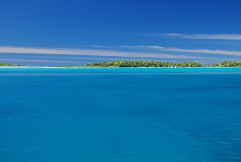
The picture accompanying this blog shows the main harbor to the right and the pond to the left. I took the picture from the mast while anchored in the pass leading to the lagoon.
Some final notes: There is a fair amount of traffic in the pass so you do not want to anchor in the intersection. Unlike the lagoon pass anchorage there is very little current in the main harbor and the pond. The tidal change is about 1 to 1.5 feet. The water has been murky/cloudy most of the time we have been here making it even more important to use the light of the sun to aid in navigation. The main harbor always has little or no visibility and the pond is only slightly clearer (today it was very clear and I could see most of the bottom in the pond). The lagoon pass seems to have the best visibility for anchoring, mostly from the ripping current. The island is very low so it does not seem to effect the wind speed or direction in any of the anchorages. I have found that the predicted wind (GRIBs) for this area is exactly what we get in the anchorage(s). The best part is that no matter what spot you anchor you are completely surrounded by reef and there is very little room for fetch so the sea state is very calm.
The picture accompanying this blog shows the main harbor to the right and the pond to the left. I took the picture from the mast while anchored in the pass leading to the lagoon.
Comments
| Vessel Name: | Zen |
| Vessel Make/Model: | Atlantic 48' catamaran |
| Hailing Port: | Newport, RI |
| Crew: | Tom, Monique and Kids |
| About: | |
| Extra: | |
| Home Page: | http://www.sailblogs.com/member/zen/ |
| Social: |
|

Zen's Photos - s/v Zen - family cruising catamaran (Main)
 |
New Zealand, Dockwise, and Florida
82 Photos
Created 14 January 2010
|
 |
Bangkok, New Delhi, Rhode Island holidays and New Zealand
118 Photos
Created 27 December 2009
|
 |
 |
 |
 |
 |
 |
Pacific Ocean Passage and French Polynesia
120 Photos
Created 19 May 2009
|
 |
 |
Panama Canal, Costa Rica and Las Perlas
118 Photos
Created 28 January 2009
|
 |
Cartagena, Panama, Puerto Rico/US, and Costa Rica
111 Photos
Created 30 December 2008
|
 |
 |
 |
 |
 |
Delivery from Maine to Newport summer 2007
15 Photos
Created 27 April 2008
|
 |
November 2007 - Tom, John and Scott
11 Photos
Created 27 April 2008
|
 |
American Virgin Islands and British Virgin Islands in 2007
358 Photos
Created 27 April 2008
|
Zen
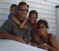
Who: Tom, Monique and Kids
Port: Newport, RI
Gallery


Blog Entries
SailBlogs Friends


Boat email - checked daily-:
sailingzen[at]gmail.com -use the @ symbol for [at]
