Aboard Aponivi
25 February 2011 | Charlestown, Nevis
29 December 2010 | Falmouth Harbor, Antigua
26 October 2010 | Palma
01 October 2010 | Ciutadella
19 September 2010 | Palma de Mallorca
07 September 2010 | Gibralter
28 August 2010 | Lagos
31 July 2010 | 41 22.34'N; 08 45.876'W
23 July 2010
16 July 2010
06 July 2010 | Brest
03 July 2010 | 54 13.424'N
25 June 2010 | Oban
25 June 2010 | Reported from Holyhead
08 June 2010 | Bngor Marina
08 June 2010 | Holyhead and Conway
31 May 2010 | Neyland, South Wales
13 April 2010
Return from the Kingdom of Man and the Isles
03 July 2010 | 54 13.424'N
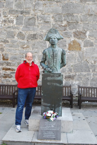
Captain Veisz and Captain Quilliam at Castle Rushen
Our "current position" has become a lagging indicator. We are back in Falmouth, having completed a 1,112 nautical mile circuit of Wales, Scotland, Northern Ireland, and the Isle of Man. Indeed, by the time you read this (if anyone is actually reading this) we may well be in France. Weather permitting, we will begin our Channel crossing on Sunday July 4, and arrive at Brest on July 5.
For now, however, we will let our "current position" mark linger on the Isle of Man, making it easy to get a Google Earth view of this very interesting part of the journey, until we have new territory to enter.
As the last blog enrty ended, we were entering Peel Harbor, on the west coast of the Isle of Man. (The Isle is in the middle of the Irish Sea, equally distant from England, Scotland and Northern Ireland.) The path into the harbor wound around the base of Peel Castle, where outer walls that have stood for six centuries encircle a tower that was built more than a thousand years ago, the remains of a cathedral that was begun in the 1150's, and the 12th century fortifications of Manx kings who ruled a vanished kingdom -- the Kingdom of Man and the Isles -- that did exist once upon a time, long, long ago.
At its zenith in the 11th through 14th centuries, the Kingdom embraced Man and the Western Islands of Scotland: principally Islay, Jura, Mull, Iona and Skye. To a large extent, the part of our voyage from Iona through the Isle of Man was a tour of this vanished Kingdom. One of the remarkable aspects of sailing through this realm is that what we saw from our boat is almost exactly what was seen by the people whose travel from island to island knitted together the Kingdom -- the Celtic "saints" who travelled these waters in the sixth century, the Vikings who travelled them in the eigth century, the kings and would-be kings who sailed these waters a thousand years ago. The view from the water is essentially unchanged. Fortunately, things have calmed down a bit on land.
Much of the Kingdom's history is recorded in a document, the Chronicles of the Kings of Man and the Isles, that was compiled in the 13th and 14th centuries. Like this blog, the writing was not strictly contemporaneous, but close enough to be reasonably reliable. A more recent history described the Chronicles as "good medieval stuff, full of rebellion, grisly mutilation, crusading and tyranny." One portion caught my attention both for its substance and for its style, which blends elements of the Passover Hagadah and a Monty Python script. The portion focuses on the rise of Godred Crovan, said to be "born of an Irish Viking Royal House", who seized control of the Kingdom in 1079 and established a dynasty that lasted for nearly two centuries. Describing Godred's vistory, on his third attempt to take the Kingdom, the Chronicles state that when his opponents, who
"saw themselves defeated without any place for them to escape to,
for the tide had filled the riverbed at Ramsey, and the enemy was
pressing from the other side, begged Godred with pitiful cries to spare
their lives. Moved with compassion and taking pity on their plight, since
he had been reared among them for some time, he called off his army
and forbade them to pursue them further."
Compassion and pity not yet havng been perfected . . .
"The following day Godred gave his army the option of either
dividing Man among themselves and living in it, if they so preferred,
or of plundering the land entirely and returning home. It pleased
them more to lay to waste the whole island and to enrich themselves
with its valuables, and thus to return to their homes."
Oh well.
Notwithstanding a few such misteps, and the shrinkage of the Kingdom to Man alone, it has much to offer. Once we rounded Peel Castle, we passed through a narrow entrance, into a long harbor in which floating docks were just installed just last year. The harbor, like many around the UK, functions much like a giant canal lock. Waters at Peel rise and fall with the tide as much as 27 feet. A few hours before or after we entered the harbor it would have been possible to walk across the channel without getting your feet wet. To keep boats afloat in the harbor a lift gate is raised into position two hours after high tide, sealing the harbor until two hours before the next high tide. For the eight hours between openings, you are either locked in or locked out, so timing is everything when planning a trip to the island.
Tied up in our slip, the castle dominated our view astern. On our port side, a very attractive town, with buildings and narrow streets dating to the 1600's and 1700's, lines the waterfront. On our starboard side, there was nothing but green hills.
We spent part of the first day getting our bicycles out of the engine room and onto the roads. Our range was limited by my struggle with hills that Lorraine failed to notice, and by the magnetic attractionl of the Waterfall Pub when it came into view not very many miles south of Peel.
Day two we took a bus to Castletown, on the south coast of the island. And from there we travelled to a few other destinations on a narrow gauge steam railroad that has been in service since the 1850's. The gleaming red and brass locomotives, and the red wooden coaches, are perfectly preserved. The preservationist trophy however, goes to Castle Rushen in Castletown. Completed in the early 1400's, it rp[laced Peel Castle as the seat of power. Tapestries hang from its walls, a fire burns in the kitchen, the table is set in the dining hall.
Outside the castle we came upon another Nelson connection, although an indirect one. At the base of the walls stands a statute of John Quilliam, a lieutenant on Victory, Nelson's flagship at the battle of Trafafgar, and later the captain of his own ship. We asked a Castle docent if he could tell us more about the lieutenant's role at Trafalgar his reply began with the promising, "ah yes, my wife's a Quilliam." As he related, and as some quick research confirmed. Quilliam was at the wheel of Victory as it led one of the two columns advancing toward the combined French and Spanish fleet. Good helmsmanship was essential to Nelson's plan. The combined fleet was in a traditional line of battle, the bow of one ship close behind the stern of another. Nelson's plan required his ships to approach the enemy line at nearly a right angle, and then required each ship to force its way between two adversaries. One British ship would sail into one gap, the next ship into the next gap, and so on. This made for a perilous approach; with canons pointing out the sides of each ship, and few guns pointing ahead, it gave the combined fleet much time to fire at the British, before British guns could be brought to bear on a target. The potential reward was that every British ship that made its way into the enemy line could fire all of its canons (110 in the case of Victory) point blank into the transoms and bows of the enemy, sending metal hurtling down the length of the ships.
Quilliam was at Victory's wheel, fortunately for him at the side of the wheel, when it was blown away by a canonball. He rushed two decks below to a giant tiller (normally controlled by lines and pulleys from the wheel) and organized a team of 40 men to handle the tiller, under his command, as bearings came down from above. As the presence of the statute suggests, he did a good job, forcing Victory through the line directly behind the French flagship Bucentaure.
An elegant building in the town center, a stone's throw from the castle, was Quilliam's home after Trafalgar.
On our final morning at Peel we waited for the gate to open, waited for the water to rise another few feet, and then began to retrace our steps southward. We reached North Wales (Holyhead) in 10 1/2 hours; continued to two anchorages in South Wales (Fishguard and Dale Bay) over the next two days; and then commenced what turned into an unexpected marathon to the outskirts of Falmouth.
We left Dale at noon on June 27, intending to sail 117 mile to the Isles of Scilly, to arrive as the sun was rising, and to anchor in one of the little island harbors that look so inviting in the guide books. We had some fairly substantial swells along the way, but nothing terrible, and arrived ahead of schedule. For about an hour, we stood off the northern edge of the islands, killing time while waiting for the sun to illuminate out destination. When the sunlight came, the view was not encouraging. The swells that seemed benign at sea were breaking violently around the islands, and sending nasty waves through the gaps between them. Water was shooting skyward at every rocky outcropping, of which there are many. The entrance we had intended to take was untenable. We went around to the south side of the Isles and found a way in, but no shelter was to be had there. We were at the highest of high tides, and low lying areas that might have provided shelter from the seas at other times were submerged, allowing the seas to run between the islands unimpeded. Finally, we poked our bow into a few south-facing anchorages on the southern periphery, where shelter from the seas might be found for a time, but where anchored boats would soon become vulnerable to forecast southerly winds. These little indentations could only contain a few boats, and were more than filled to capacity. The slightest shift in wind or tide could easily have made a tangled mess of the boats and their anchor chains. The bosts were reminiscent of refugees in a war zone, huddled together in one tiny shelter before being forced to flee to another. A corruption of the Statute of Liberty poem, "huddled masts yearning for a lee" came to mind.
As tired as we were, we decided that the safest and most attractive option was to set a new course to the Helford River, sixty miles east (past Land's end and Lizard Point) and only a few miles from Falmouth. As soon as we set sail for the Helford energy seemed to flow back into our systems, and the day became very enjoyable. Over the VHF radio, however, we could hear that the seas were causing havoc on the north coast of Cornwall. Broadcats repeatedly sought boats in one position or another (none anywhere near us) to assist in searches for persons in the water. Results varied. A fishing boat rescued one person, four swimmers who had been swept out to sea were rescued by a combination of RNLI lifeboats and helicopters. Another was still missing at the time we reached the Helford and dropped anchor. Savoring its tranquility, we dropped our anchor, had a little wine, and slept for twelve hours.
The next day it was back to the Port Pendennis Marina in Falmouth, and to a combination of preparations for the next leg, and get togethers with some of the friends we had made here and hope to see again.
Comments
| Vessel Name: | Aponivi |
| Vessel Make/Model: | Apogee 50 |
| Hailing Port: | New York, NY |
| Crew: | Howard and Lorraine Veisz |
Gallery not available
Who: Howard and Lorraine Veisz
Port: New York, NY