Aboard Aponivi
25 February 2011 | Charlestown, Nevis
29 December 2010 | Falmouth Harbor, Antigua
26 October 2010 | Palma
01 October 2010 | Ciutadella
19 September 2010 | Palma de Mallorca
07 September 2010 | Gibralter
28 August 2010 | Lagos
31 July 2010 | 41 22.34'N; 08 45.876'W
23 July 2010
16 July 2010
06 July 2010 | Brest
03 July 2010 | 54 13.424'N
25 June 2010 | Oban
25 June 2010 | Reported from Holyhead
08 June 2010 | Bngor Marina
08 June 2010 | Holyhead and Conway
31 May 2010 | Neyland, South Wales
13 April 2010
Gibralter Rocks
07 September 2010 | Gibralter
H. Veisz
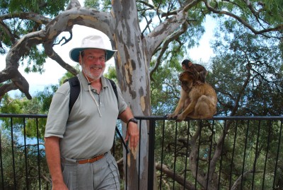
Howard (on the left) and Ape Friends
The first ironclad sign of the African coast consisted of four flashes of light. At 3:30 on Saturday morning (4 Sept.) we were nine miles southeast of Trafalgar, the scene of the great 1805 naval battle in which Nelson caught up with and destroyed the combined French and Spanish fleet, and we were heading for the Strait of Gibralter. (We were in fact following the intended path of the ill fated fleet, on a run from the Bay of Cadiz to the Med.) Eighteen miles to our south, on the northwest tip of Moracco, the Cap Spartel lighthouse was emitting its signiture four flashes every 20 seconds -- a pattern, according to our chart, that should be visibe for 30 miles under ideal conditions. We scanned the horizon for about five minutes and there it was, with the faint glow of Tanger a few miles to its east.
At this point, the gap between Spain and Morocco begins to narrow like a funnel. For the last ten miles (before the Bay of Gibralter opens to the north and the coat of Morocco drops off to the south) the continents are only eight miles apart.
At the time we spotted Cap Spartel, we still had 30 miles to go though the funnel before emerging at Gibralter. And a memorable 30 miles it was to be. When we left Rota (in the Bay of Cadiz) at 7:30 Friday evening we knew that the leventer -- an easterly wind -- would be blowing in the Strait. We checked two forecasting services. One predeicted peak winds of 14 knots, the other 19 knots. They were wrong.
By 4:46 in the morning, the apparent wind began to exceed 30 knots. (As our speed had slowed to a crawl, the true wind speed was not very much less.) By 6;30 the apparent wind was up to 34 - 35 knots, and by 7:30 it had hit 40 knots. At that point, with the wind on our nose, we were barely sustaining two knots of headway. As we entered the narrowest ten miles the wind abated to 30 knots, or slightly less, but it still took three hours to cover the ten miles.
The boat was pitching a good bit, and each drop of the bow sent spray flying across the cockpit and into the face of the person at the wheel. As the hours went on, and we became coated with salt, attempting to duck beneath each spray hardly seemed worth the effort, and we saved that exertion for the largest waves.
During this period, we stayed within two miles of the Spanish coast, in a strip between the shore and the "traffic seperation zone" that contained designated inbound and outbound lanes for commercial traffic. Even so, a string of lights along the Moroccan coast was plainly visible. Between us and that shore a steady procession of tankers and other cargo ships made their way through the strait. On our AIS screen (which tracks the location and movement of other vessels) the icons for inbound shipping were lined up end-to-end, making an unbroken line.
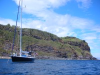
At 11:30, we emerged from the Strait and, up ahead, the Rock of Gibralter came into view. The winds continued to abate. But they were much in evidence at the Rock itself, where clouds formed at the peak and streamed downwind from there. Later, when Aponivi was tied up at Marina Bay, and we walked along a path near the top of the Rock, we could see the cloud form where the wind swept over a crest directly ahead of us, and then walked only a few feet below the base of the cloud.
This is our second visit to Gibralter by sailboat, and it has lost none of its beauty or interest in the intervening ten years. On the Rock above the town, hundreds of Barbary Apes continue to frolic. Completely at ease with people, they are happy to sit next to you, or simply ignore you while you gawk an arms length away. But beware of plastic bags. Signs warn visitors that the apes know that plastic bags are likely to contain food, and will rip them from your hands. We watched one person prove the point. She walked out of a building with a bag of fruit, and half a dozen apes went, well ape, tore apart the bag and ran off with the goods.
Down below are layers of well preserved history: seige tunnels from which British forces defended Gibralter from the Spanish during the Great Seige of the 1790's; Rosia Bay, where Nelson's Victory docked -- victorious but heavily damaged -- after the Battle of Trafalgar; and World War II tunnels, where an entire base, including a hospital and Spitfire assembly plant, was built underground.
At the base of the Rock the town of Gibralter retains an attractive historic core, within fortress walls that have stood for hundreds of years. It also appears to remain a place of great harmony. In this tiny enclave are four synagogues, a number of mosques, and a number of churches -- all of which apper to have full congregations that coexist quite nicely. If there is any hostility, it was undetectable on this trip.
We are about to untie and head east, planning to get to Ibiza on about September 12 or 13.
The first ironclad sign of the African coast consisted of four flashes of light. At 3:30 on Saturday morning (4 Sept.) we were nine miles southeast of Trafalgar, the scene of the great 1805 naval battle in which Nelson caught up with and destroyed the combined French and Spanish fleet, and we were heading for the Strait of Gibralter. (We were in fact following the intended path of the ill fated fleet, on a run from the Bay of Cadiz to the Med.) Eighteen miles to our south, on the northwest tip of Moracco, the Cap Spartel lighthouse was emitting its signiture four flashes every 20 seconds -- a pattern, according to our chart, that should be visibe for 30 miles under ideal conditions. We scanned the horizon for about five minutes and there it was, with the faint glow of Tanger a few miles to its east.
At this point, the gap between Spain and Morocco begins to narrow like a funnel. For the last ten miles (before the Bay of Gibralter opens to the north and the coat of Morocco drops off to the south) the continents are only eight miles apart.
At the time we spotted Cap Spartel, we still had 30 miles to go though the funnel before emerging at Gibralter. And a memorable 30 miles it was to be. When we left Rota (in the Bay of Cadiz) at 7:30 Friday evening we knew that the leventer -- an easterly wind -- would be blowing in the Strait. We checked two forecasting services. One predeicted peak winds of 14 knots, the other 19 knots. They were wrong.
By 4:46 in the morning, the apparent wind began to exceed 30 knots. (As our speed had slowed to a crawl, the true wind speed was not very much less.) By 6;30 the apparent wind was up to 34 - 35 knots, and by 7:30 it had hit 40 knots. At that point, with the wind on our nose, we were barely sustaining two knots of headway. As we entered the narrowest ten miles the wind abated to 30 knots, or slightly less, but it still took three hours to cover the ten miles.
The boat was pitching a good bit, and each drop of the bow sent spray flying across the cockpit and into the face of the person at the wheel. As the hours went on, and we became coated with salt, attempting to duck beneath each spray hardly seemed worth the effort, and we saved that exertion for the largest waves.
During this period, we stayed within two miles of the Spanish coast, in a strip between the shore and the "traffic seperation zone" that contained designated inbound and outbound lanes for commercial traffic. Even so, a string of lights along the Moroccan coast was plainly visible. Between us and that shore a steady procession of tankers and other cargo ships made their way through the strait. On our AIS screen (which tracks the location and movement of other vessels) the icons for inbound shipping were lined up end-to-end, making an unbroken line.
At 11:30, we emerged from the Strait and, up ahead, the Rock of Gibralter came into view. The winds continued to abate. But they were much in evidence at the Rock itself, where clouds formed at the peak and streamed downwind from there. Later, when Aponivi was tied up at Marina Bay, and we walked along a path near the top of the Rock, we could see the cloud form where the wind swept over a crest directly ahead of us, and then walked only a few feet below the base of the cloud.
This is our second visit to Gibralter by sailboat, and it has lost none of its beauty or interest in the intervening ten years. On the Rock above the town, hundreds of Barbary Apes continue to frolic. Completely at ease with people, they are happy to sit next to you, or simply ignore you while you gawk an arms length away. But beware of plastic bags. Signs warn visitors that the apes know that plastic bags are likely to contain food, and will rip them from your hands. We watched one person prove the point. She walked out of a building with a bag of fruit, and half a dozen apes went, well ape, tore apart the bag and ran off with the goods.
Down below are layers of well preserved history: seige tunnels from which British forces defended Gibralter from the Spanish during the Great Seige of the 1790's; Rosia Bay, where Nelson's Victory docked -- victorious but heavily damaged -- after the Battle of Trafalgar; and World War II tunnels, where an entire base, including a hospital and Spitfire assembly plant, was built underground.
At the base of the Rock the town of Gibralter retains an attractive historic core, within fortress walls that have stood for hundreds of years. It also appears to remain a place of great harmony. In this tiny enclave are four synagogues, a number of mosques, and a number of churches -- all of which apper to have full congregations that coexist quite nicely. If there is any hostility, it was undetectable on this trip.
We are about to untie and head east, planning to get to Ibiza on about September 12 or 13.
Comments
| Vessel Name: | Aponivi |
| Vessel Make/Model: | Apogee 50 |
| Hailing Port: | New York, NY |
| Crew: | Howard and Lorraine Veisz |
Gallery not available
Who: Howard and Lorraine Veisz
Port: New York, NY