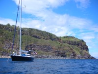
Aboard Aponivi
25 February 2011 | Charlestown, Nevis
29 December 2010 | Falmouth Harbor, Antigua
26 October 2010 | Palma
01 October 2010 | Ciutadella
19 September 2010 | Palma de Mallorca
07 September 2010 | Gibralter
28 August 2010 | Lagos
31 July 2010 | 41 22.34'N; 08 45.876'W
23 July 2010
16 July 2010
06 July 2010 | Brest
03 July 2010 | 54 13.424'N
25 June 2010 | Oban
25 June 2010 | Reported from Holyhead
08 June 2010 | Bngor Marina
08 June 2010 | Holyhead and Conway
31 May 2010 | Neyland, South Wales
13 April 2010
Sailing the North Coasts of Menorca and Mallorca
26 October 2010 | Palma
H. Veisz
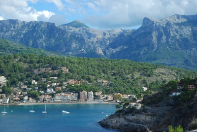
Aponivi at anchor in Puerto de Soller
8,802 miles after we set out from Rhode Island, Aponivi is at rest in Palma. We will remain here until mid-November when a Dockwise ship is scheduled to take on a cargo of sail and power yachts bound for the Caribbean.
To say that I regret sending Aponivi across as cargo, rather than sailing across with the trade winds, is a great understatement. But the decision is not without its benefits. We have been able to remain in the Med far longer than would have been prudent if we were making the westward passage. That passage invariably begins with a positioning run to the Canaries (705 miles southwest of Gibralter and 1,150 miles from here), a trip that should be completed by the end of September. One then sits in the Canaries until nearly December, awaiting the weather window for the westward leg.
And if our boom problem confined us to a smaller area of the Med than we had hoped, we can at least be grateful that we are in an area of great beauty and historical interest, and an ideal location for making repairs. We have been making the most of our surroundings while preparing for the many miles -- from the Caribbean to the northeast -- that still await us.
Our last bit of European sailing adventure took us along the north coasts of two Ballearic Islands, Menorca and Mallorca. These are rugged coasts that look, for the most part, as if they had never been inhabited. There are good reasons for that.
Both coasts, particularly Menorca, are in the path of the tramontana, the Med´s fearsome north wind. Our pilot book states that "the tramontana can be dangerous in that it can arrive and reach gale force in as little as 15 minutes on a calm sunny day with no warning". (Reading further, it appears that the better the weather seems, the more one has to prepare for the worst -- good weather being the harbinger of bad weather.) Once the tramontana begins to blow it lasts¨"at least three days and, on occassion, may last for a week or longer". During winter months, the tramontana "blows for a third of the time" at "force ten (50 knots) or above", a force that would send enormous waves crashing against the shore.
Mallorca´s north coast is a 50 mile long mountain range, the Sierra de Tramontana. Cliffs are a common feature of the European coasts but these are a different order of magnitude. One of the peaks, Puig Major, rises 4,750 feet above sea level, and many others rise half a mile or more from the water's edge. Sailing along the coast, a few small clusters of stone houses -- villages that go back 700 years or more -- can be seen clinging to mountainsides high above sea level. For most of the way there is no other human imprint.
Nature provided one spot on each coast where a sea level village could take root and some harbor facilities could be established. On Menorca, that spot is the fishing village of Fornells, home to 489 hardy souls. On Mallorca, it is the larger harbor of Soller, a hiker's gateway to the mountains and their ancient villages.
We reached Fornells on the fourth of October. As we passed through the narrow entrance to Fornells Bay the village appeared on our right, huddled in a recess that provides some shelter from the north winds. A stone quay extends the curvature of the land, forming a harbor with room enough for local fishing boats and a few visitors to berth side-by-side, one end secuired to the quay and the other to a mooring line.
We were directed to a berth at the outer end of the quay, the only place with room for a boat of our size to maneuver. In a stiff cross wind, Lorraine struggled to attach the mooring line to a deck cleat before the bow was pushed downwind and the rope was pulled from her hands. (This was Lorraine´s job because she would rather do that than handle the controls, and that seems to be for the best in most circumstances.) We managed to secure on our third attempt, with the assistance of a helpful dock attendant and a strong crew member on the neighboring boat.
Our berth gave us a fine view of the bay, where everything beyond the small bit of shoreline occupied by the village remains in its natural state.
In the evening we did what visitors are expected (and happy) to do: we had a seafood paella at a restaurant on the seawall. Reading the English translations on my menu, I came to a dish of "paella with mushroom and rabbi". Concluding that this was a typographical error rather than a vestige of the inquisition, and feeling that my very non-kosher seafood paella provided good cover in any event, I put the menu aside and enjoyed my meal.
On our second and final evening in Fornells a three masted tall ship -- square sails furled on its yardarms -- entered the harbor and dropped anchor. With nothing but woodlands as a backdrop it was a scene straight from the 18th century, when tall ships of the Royal Navy and its adversaries prowled these waters.
In the 1700´s Fornells was essentially an unguarded back door to the heavily fortified harbor at Mahon. When Britain first captured Menorca in 1708, part of its invasion force landed at Fornells. And when Britain recaptured Menorca in 1798, another landing took place here. The need to take Menorca a second time gives rise to an interesting bit of naval, literary, and cullinary history.
By 1756, Britain had controlled Menorca and the prime port of Mahon -- the base of the Royal Navy´s Mediterranean Fleet -- for 48 years. Then, the European powers squared off in what we (in the US) know as the French and Indian War, what Europeans call the Seven Year´s War, and what could well have been called the First World War. One of France´s early objectives was to take Menorca, depriving Britain of a base close to the French coast. A French invasion fleet anchored near Ciutadella, sending 12,000 men ashore. From there, the French marched across the island to Mahon, while its naval escort, 12 ships of the line and five frigates, patrolled the coast.
Only three British Frigates were in Mahon at the time of the invasion, and they were sent to sea rather than risk being captured or trapped by a long blockade. British land forces prepared to make their stand in Fort San Felipe, at the entrance to Mahon Harbor. Bombarded by French artillery, and running low on food and ammunition, the defenders pinned their hopes on the timely return of the mediterranean fleet, then under the command of Admiral John Byng.
Byng´s fleet rached Cape Favaritx -- eight miles east of Fornells and an equal distance north of Mahon -- seven days after the seige began. And then he stopped. By some accounts, he waited while attempting to make contact with the fort´s defenders. While he waited, the French fleet came into view.
The opposing fleets were well matched, 18 British ships with 874 cannons against 17 French ships with 894 cannons. The British fleet gave chase, but only a few ships at the front of its line (Byng´s flag ship not among them) ever came within firing range. After an exchange of cannon fire that inflicted no seriouis damage on either fleet the French maneuvered out of range and Byng maneuvered all the way back to Gibtalter, 450 miles away. While he waited for reinforcements the British troops at Mahon were forced to surrender.
Byng was court martialled for his timidity, and executed by a firing squad. His execution was the inspiration for Voltaire's statement, in Candide, that "it is good to kill an admiral from time to time to encourage the others." Subsequent encounters between the Royal and French navies suggest that there is a lot of truth to that statement..
The French went on to lose the war and to surrender Menorca to the British (along with France´s possessions in Canada, the Gulf coast from Florida to the Mississippi River, and Granada). But France´s occupation of Mahon lasted long enough for the French commander´s chef to perfect a variation of a local sauce and present it at a victory celebration in Paris as "Mahon-esa" -- mayonaise.
We looked forward to seeing more of the tall ship in the daylight. But we awoke the morning to find that it was already gone. We departed a few hours later.
To sail west from Fornells we first had to round Cabo Caballeria, a penninsula that extends two miles northward and ends in a vertical wall of rock 265 feet tall. When we turned west at the end of the penninsula the the tall ship -- now with with 12 sails pulling it downwind -- came into view. A tall ship under a full set of sails is a magnificent site, and one that gets the adrenaline pumping. We "gave chase" and, in seven miles, we were alongside it, shooting a broadside of photographs, before we moved ahead and put distance between us.
With a pleasant westerly wind and smooth seas, we steered into a fair weather anchorage to spend a final night on Menorca before jumping over to Mallorca. We crossed the next day, in a heavy mist that hid Mallorca until we were nearly upon it. As we moved along the coast the mist dissipated, and the mountains came fully into view. At one point a ravine led down to the sea, and the coastal range parted enough to motor into the gap. Mountains on either side of us framed a towering peak a short distance inland.
After 27 miles of coasting we reached Puerto de Soller. A marina, fishing boats, and mooring field fill the eastern half of the circular bay; the more exposed western half is an anchorage. We opted for the anchorage.
Two miles inland, at a slightly higher elevation, the town of Soller is nestled in a valley. Lucia Graves, a writer who grew up in the mountain village of Deia in the decades after World War II, described the valley as a "large bowl with one side broken off where it meets the sea." No roads penetrated the surrounding mountains until well into the 19th Century. Its long isolation had a lasting and largely positive influence. Graves wrote that the valley "was like an island within an island, where life was ruled by the cycles of its natural habitat, and by rituals so ancient that nobody could remember their origin....[O]nly the earth and the water and the elements seemed to govern people's lives...."
Before the 13th century "reconquest" of Mallorca, the Moors who inhabited the area named it Sullier, the Arabic word for "golden Valley". The name is still appropriate. The town of Soller is surrounded by orange and lemon trees. Walking from the sea in any direction, the land slopes upward ever more steeply. The citrus groves give way to olive trees that grow on terraced hillsides, the terraces held in place by row after row of stone walls. The terraces and olive trees are legacies of the Moors, and the tortured trunks of the oldest trees look old enough to have been planted by them. At about 2,00 feet, the snow line, the olive trees end. pine forests rise above that, and then only rock.
During our four days in the area we rowed ashore each morning and spent the days hiking through the mountains. Ancient cobblestone pathways lead from Soller to the hamlets and monastaries that dot the mountainside. Because of the steepness of the terrain, miles of cobblestone stairways were built to aid the traveller. The age of these pathways can be inferred from the date of the first recorded restoration program. In 1400, the church offered "forty days of indulgence" to anyone who helped restore what were already being described as the ancient walkways.
Hiking these paths was as good an activity as can be done on land. At the right elevations, olives hang within reach on every branch. Sheep bells and church bells peal. Streams tumble down the mountains along some of the pathways, and rushing water can usually be heard even when it cannot be seen.
We never tired of our stay but, like the valley life that Graves described , life on board is governed by the elements. During our fifth night in the bay wind charts that we received on our satellite phone warned of a weather change. Gale force winds from the northeast were expected to lash the coast within 36 hours. We resolved to leave in the morning and return to Palma on the sheltered south coast. We spent a mostly sleepless night at anchor. By midnight, swells found there way into the harbor far ahead of the winds thast produced them. With the harbor winds and currents conspiring to keep us broadside to the swells, we rocked through an arc of at least 40 degrees throughout the hours of darkness.
When we took off in the morning we found the progress far smoother than our night at anchor. Our two exciting seasons of voyaging-- the Atlantic crossing; the crossings of the Irish Sea, the English Channel, and the Bay of Biscay; the 25 foot tides and fierce overfalls of the British and Brittany coasts; the exciting run through the Strait of Gibralter -- ended with a quiet day sail. When the gale arrived on the north coast, we were snug in our well protected berth on the south coast.
For those who joined us during our voyage, we must do it again sometime. As for the blog, it shall return, with the Caribbean saga, in early December. Stay tuned for any bulletins.
Comments
| Vessel Name: | Aponivi |
| Vessel Make/Model: | Apogee 50 |
| Hailing Port: | New York, NY |
| Crew: | Howard and Lorraine Veisz |
Gallery not available
Who: Howard and Lorraine Veisz
Port: New York, NY