Aboard Aponivi
25 February 2011 | Charlestown, Nevis
29 December 2010 | Falmouth Harbor, Antigua
26 October 2010 | Palma
01 October 2010 | Ciutadella
19 September 2010 | Palma de Mallorca
07 September 2010 | Gibralter
28 August 2010 | Lagos
31 July 2010 | 41 22.34'N; 08 45.876'W
23 July 2010
16 July 2010
06 July 2010 | Brest
03 July 2010 | 54 13.424'N
25 June 2010 | Oban
25 June 2010 | Reported from Holyhead
08 June 2010 | Bngor Marina
08 June 2010 | Holyhead and Conway
31 May 2010 | Neyland, South Wales
13 April 2010
An Appendicitis at Nevis
25 February 2011 | Charlestown, Nevis
H. Veisz
We left Antigua's Falmouth Harbor on January 5 with fresh provisions, an ambitious cruising plan, and a ticking time bomb. Lorraine had already felt sharp abdominal pains during our last full day in Antigua, but not enough to deter her from walking the four mile round trip from the Catamaran Marina to the customs office at Nelson's Dockyard, to seek medical help, or to delay our departure plan. To the contrary, she was determined to move on, and so we did.
A night at anchor in Five Island Harbor, on the west coast of Antigua, passed pleasantly. Indeed, we thoroughly enjoyed the fine surroundings, and the fact that we shared the large harbor with only three other yachts -- a nice contrast to the crowded harbor at Falmouth. Lorraine felt better. Nevis beckoned, only 48 miles away. And so we sailed on.
Nevis is a very small island, an oval about five miles from east to west, and seven miles from north to south. There is no protected harbor, but the Nevis Port Authority has installed 100 moorings on the leeward side of the island, along Pinney's Beach. The moorings stretch from Charlestown (Nevis' principal town) to Sunshine's (Nevis' principal beach bar). Use of the moorings is mandatory, but availability is not a problem. When we arrived about 97 of the 100 moorings were inexplicably vacant.
Lorraine's abdominal pain was largely forgotten as we enjoyed a fast downwind sail to Nevis, rounded its southern end, and continued to the mooring field. The wind was blowing strongly as we approached the moorings. Lorraine, now at the wheel, struggled to hold us alongside a mooring while I threaded two lines through a small metal loop atop the mooring ball. The first attempt failed. We secured the boat on the second pass.
We finished at 17:00, too late to report to customs, just right for mixing rum punch and watching the sunset. The view was splendid: to the east the long line of Pinney's Beach, backed by palm trees, stretched in both directions; across a narrow channel to the north St. Kitts was clearly visible, its shoreline curving to the northwest; elsewhere there was only water and the setting sun. Nothing seemed very much amiss. Just a bit of tenderness.
The next morning we took our dinghy to a dock at the heart of Charlestown's waterfront. It was Sunday, and quiet. A taxi driver, John, greeted us at the dock and offered some useful information. Our destinations (the port authority office, customs and the immigration office) were too close to use his services -- a fact that did not diminish his good cheer. As we walked through town the only activity was in the churches, where filled pews could be seen through open doors.
Our last stop was the immigration office, located at the police station. While the officer was examining our passports with an intensity suitable for a terrorism suspect, we struck up a conversation with a couple from Sailacious, another American sloop, who were awaiting similar scrutiny. We planned to rendezvouz with them later that day at Sunshine's.
Symptoms began to accumulate. Lorraine uncharacteristically stated that she would like to return to Aponivi to rest. Tenderness in her lower right abdomen increased. She opted to stay behind when I took the short dinghy ride to Sunshine's. I left with a handheld VHF in case Lorraine needed to radio for assistance. The call came quickly -- about half way through my first "Killer Bee", Sunshine's signature drink. With the help of our new "Sailacious" friends I pushed the dinghy off the sand and sped back to Lorraine.
By this time, Lorraine had added a fever to her list of symptoms, and was starting to think appendicitis among a list of other possibilities. (Classic appendicitis symptoms include four to six hours of dull abdominal pain, followed by sharp pain in the lower right abdomin, and a low grade fever of 99 to 102 degrees -- all in rapid succession. Lorraine had sharp but short-lived pain in Antigua, followed five days later by lower right quadrant tenderness and fever, an atypical progression that clouded the diagnosis.) As a retired nurse her concern about a possible appendicitis carried great weight. It also caused considerable anxiety, knowing that a ruptured or perforated appendix -- one possible ending -- could spread infection throughout the abdominal cavity. If that happened, as it often does when medical care is delayed, it could prove fatal.
We got into the dinghy, sped back to Charlestown, and taxied to the island's one medical facility, the small Alexandra Hospital. Lorraine was whisked into the emergency room and a surgeon was summoned from elsewhere on the island. An IV was set up. And then we waited and contemplated our surroundings. Some of the furnishings in the room had more rust than I would like to see. I began to wonder whether the surgeon's skills (we had not yet met him) might be a little rusty too. I vividly recalled a former partner's advice that we purchase med-evac insurance before we set sail and, not knowing what was in store, I wished I had done so.
This was a part of Caribbean life that we had not seen before, and that we had not really thought about. The hospital reflected the differences that we had come to know between the Caribbean and the United States, and tended to magnify them. The island could not afford all of the sophisticated equipment that would be standard in a US hospital, but what it did have was offered generously. Nobody asked what insurance we had, only what help we needed.
When we were billed for anything, it was in the same small amounts that islanders were asked to pay; it made no difference that we had a yacht moored in the harbor. (A donation will be made.) The nurses were very caring, and very competent.
The surgeon arrived, clad in a red t-shirt, shorts and sandals. He conducted a conscientious examination, feeling for abnormalities and using an ultra-sound device that was in the ER for an inside look. The literature says that "diagnosing an appendicitis can be tricky". Symptoms are "frequently vague or extremely similar to other ailments", some of which have the sound of doom. Lorraine's case was particularly difficult to diagnose.
In a few percent of appendix cases -- including Lorraine's -- a strong immune response causes the tissue surrounding the appendix to swell so much that it walls off the appendix and prevents infectious material from spreading. The reaction can be life-saving, but it also makes an appendicitis harder to detect, and significantly complicates the surgery if an appendectomy is begun.
Based on what Lorraine told the surgeon about the slow progression of her symptoms, what he had felt, and what he had seen on the ultra-sound, he tended to discount the appendicitis theory. (Two doctors in New York did the same, before ordering a CT Scan that dispositively revealed an appendicitis.) One of the dread alternatives entered the conversation, and that possibility lingered in our minds overnight.
The next morning, following his instructions, we returned for a more sophisticated ultrasound. The dread alternative was ruled out. The actual problem remained elusive. Two powerful antibiotics were prescribed and provided -- a precaution that may have made all the difference. We were given the green light to fly home for further diagnostic tests and treatment.
The few taxi drivers who wait at the Charlestown dinghy dock are a font of information and a source of encouragement. The Sailacious crew came asking about us and were told by a driver that we were at the hospital. As we walked past the group to our dinghy, one driver (the "Music Man") assured us that "Nevis was a blessed island" and that Lorraine was "already healed". Nevertheless, we began to tackle the logistics of getting Lorraine to a New York hospital, and getting Aponivi back to the safe haven that only Antigua could provide.
We secured next day flights from St. Kitts to Miami and from Miami to New York. The small Port Zante marina at St. Kitts had a slip available, and we departed for it at once. As part of a two person crew, a doctor's note could not get Lorraine a day off, and she performed without complaint when it was time to hoist the dinghy on deck, and rope the piings at Port Zante.
A chance comment a few days before we left Falmout Harbor provided all of the information I needed to meet our longer term boat needs. Stan at Antigua Rigging (as fine an outfit as can be found anywhere) mentioned that a customer had just suffered a medical emergency on board, and that he had dispatched a crew to retrieve their boat. I described our predicament to Stan over the telephone, and he took it from there. At his direction, a local yacht agent met us at St. Kitts to handle customs and immigration matters, and a highly proffessional crew arrived at 07:00 the next morning to sail the boat back to Falmouth Harbor. The yacht agent, Rickie, returned at the same time to handle the departure formalities. Then, before we parted, he asked if he could take our hands and say a prayer for Lorraine. His prayer, and his genuine concern, warmed our hearts.
We then headed to the airport. Up north, a record breaking blizzard was heading toward New York, shutting airports all along its route.
We arrived at the St. Kitts airport with a well justified sense of urgency. We had been lucky so far, but we knew we were pressing our luck if it was an appendicitis. The storm delayed the aircraft's arrival by three hours and we began to anticipate a night at Miami. That turned out to be overly optimistic. The flight crew determined that another leg would put them over the maximum number of hours they could fly in a day, and our depature was put off until 06:00 the next morning. The Airline put everyone up for the night at a Marriot resort, which would have been a splendid experience under other circumstances.
By the time we left St. Kitts, the storm had reached the northeast, closing airports from Washington to Boston. We approached Miami not knowing when we could take off again, but thankful that a major hospital would be within taxi range if it was needed. As we began to take comfort in that thought the pilot announced that we were "experiencing engine problems", that he had "declared an emergency", and that emergency vehicles would be on the field when we arrived. We were sitting in an emergency exit row, and I took renewed interest in the instuctions for using it. There was no need. The engines kept turning. Our decent seemd normal. But the fleet of fire engines deployed near the runway, and the absence of other aircraft from the vicinity, suggested that there had been some doubt about the outcome.
The next morning, in New York, diagnostic work continued, and ended with a CT Scan that was not available in Nevis. Lorraine was sent to the emergency room with the expectation that she would be operated on immediately. The surgeon steered a different course. When treatment is delayed to that extent, and the patient has been fortunate enough to have been saved by a defensive "wall" of surrounding tissue (a phlegmon in medical parlance), the potential complications of immediate surgery outweigh the benefits. Things are not where they belong. Mistakes can be made. The preferred course is a ratcheting up of what the doctor on Nevis had begun: three days of in-patient antibiotics, followed by a week of antibiotics in close proximity to the hospital, followed six to eight weeks later by appendectomy.
We are between the antibiotics and the appendectomy, closer to the latter. Lorraine is doing well. Apponivi, Antigua Rigging assures us, is doing well. By mid-March I expect to be underway again on Apponivi, heading back through Nevis, the Virgin Islands, the Turks and Caicos, and the Bahamas, to Charleston and my temporarily beached mate. From then on, we sail together again.
A New Year in the Caribbean
29 December 2010 | Falmouth Harbor, Antigua
H. Veisz
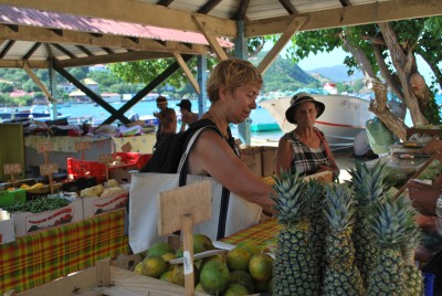
Provisioning at Iles de Saintes
The air temperature this week ranged from 77 to 81 degrees. The water temperature is always 80 point something. It's winter time in Antigua.
We are on Antigua's south coast, in Falmouth Harbor. Falmouth and adjacent English Harbor were once the base of the Royal Navy's Leeward Island Squadron. Here the wooden warships rode out hurricane seasons in relative safety and were maintained at English Harbor Dockyard, now known as Nelson's Dockyard. Nelson, as the young captain of the 28 gun Boreas, spent Christmas and New Year's Eve at the Dockyard at the end of 1784 and 1786, before sailing off to greater glory.
The English Harbor Dockyard was retired as a navy base in the late 1800's. After 70 years of neglect it was restored and brought back to life as a superyacht marina, historic site, and national park. Where the warships once put in, superyachts and lesser craft such as Aponivi now gather. When we entered Falmouth Harbor on December 15, we sailed into a world of floating palaces. Maltese Falcon, the world's largest sailing yact at 289 feet, was here. Marrying the old and the new, it has three 190 foot masts, from which 15 square sails can be unfurled at the touch of a button. The masts rotate to keep the sails trimmed to the wind. Near Maltese Falcon, and towering over it, was Mirabella V, the world's largest single mast sailing yacht. It would be an impressive sight in New York Harbor, but it cannot get in. Its 292 foot mast is 75 feet higher then the roadway of the Verrazano Bridge. The Queen Mary II can get through (barely) but not Mirabella V. Both Yachts are still in the harbor, along with others that show up regularly in yachting magazines.
Antigua also has simpler pleasures. Across the road from the Catamaran Marina, our holiday home, Sweet T's serves Philly cheese steaks and cheesebugers on an open deck done up in Caribbean colors. After nearly six months in Spain, Portugal, France, and French Caribbean islands, I can finally order my kind of food in my own language. It is something I have been longing for.
Now, about those French Islands....
Having shipped our boat from Palma on a Dockwise transport, we flew to Martinique to await its arrival. Our rendezvous point was Marin, on Martiniques's south coast. Marin has a large, well sheltered, and well marked harbor, but shoals encroach from all sides, and a long narrow shoal extends from one side of the harbor to its center. It was a good place to test our grasp of recently read rules for estimating water depth from water color.
The Dockwise vessel, Super Servant III, was due to arrive November 27. When we awoke that morning, in a hotel overlooking the harbor, it was already at anchor. Then followed the process of filling the ship's ballast tanks, lowering it 18 feet until the yachts within its cargo bay floated off their cradles, and the gunwales of the ship were no higher in the water than a floating dock. The ship was essentially a floating dock when we backed Aponivi into its 380 foot cargo bay in Palma, and a floating dock is what it became again. Only during the trans-Atlantic passage does the ship sit high in the water, its cargo bay dry and its cargo securely fastened in cradles welded to the deck.
On the 28th we, along with other owners and crew, took a launch to the ship. We stepped onto its gunwale, and then onto the deck of Aponivi. We were one of the first to load in Palma, and thus one of the last to exit in Marin. We followed a procession of power and sailing yachts, lined up four abreast in the cargo bay, as they departed. Instructions were clearly delivered to each boat by radio, and line handlers on the ship's outer walls and center divider assured a smooth start. We had briefly to maneuver in tight quarters, between the ship's wall on our port side and a 126 foot power yacht on our starboard side. Once past that, the ship's hull became a wide channel through which we motored easily out of the ship and into the bay.
Aponivi arrived in good shape, clean and with no more wear and tear than it had in Palma, 3,672 miles away. I have some lingering regrets about not sailing it back, but these are diminishing by the day. I have crossed the Atlantic three times, and I do not envy the boats that made the passage from the Canaries to the Caribbean this year. It was an unsually long passage for most boats, in weak trade winds. I looked at the crossing times for sailboats in the Atlantic Rally for Cruisers, a floatilla that is assembled each year in the Canaries for the passage to the Caribbean. Thirteen boats in the cruising division took over 30 days to cross. Another 99 boats arrived between the 25th and 30th day. A Dutch couple that we befriended in Portugal as they were heading to the Canaries on a fine 50 footer, crossed in a little over 27 days. While light winds predominated, some days must have been exceptions: one yacht lost its mast when it was a few days from the finish, and another turned back with rigging damage a few days after the start. Those who did it have my respect.
We took a slip at Marin, and it was a pleasant spot. A large number of cruising families were tied up there, and a cheerful collection of children and pets spilled onto the dock. We loaded food, became acquainted with the local rum concoctions, and began to get acclimated to the sun and rhythms of the Caribbean. And then, after a few days, we headed north along Martinique's leward coast.
We dropped anchor in Fort de France, near the wall of a 17th century fortress that rises from the waters. The fort, the town, and the mountains behind it, made for an attractive scene. Fort de France suffered somewhat on closer inspection -- our cruising guide may have been a bit over-enthusiastic -- but it certainly extended a helping hand to cruisers. A dinghy dock runs 350 feet along the town's waterfront, making it easy to get ashore to provision and to visit the few notable buildings. The best of these was the Schoelcher library, an ornate iron building that was erected at the 1899 World Exposition in Paris (the same one for which the Eiffel Tower was built) and then crated up and shipped to Martinique. Schoelcher was a leading French abolitionist and civil rights advocate-- one who believed not only that enslaved blacks should be freed, but also that free blacks should be equal. The library is a fitting tribute.
On the opposite side of the harbor, and the opposite end of the spectrum, are the remnants of a sugar cane plantation where the Emperess Josephine was born and raised, and where 150 slaves toiled. Her background and influence over Napolean may have been a factor in one of the crueller reversals of his inglorious reign. In 1793, revolutionary France issued a proclamation calling for the abolition of slavery, not immediately but soon. Martinique and Guadeloupe, 72 miles to its north, were prime targets. In 1802, Napolean rescinded that proclamation, and threw the weight of his millitary behind the plantation system.
Both the emanciption proclamation and Napolean's decree rescinding it faced practical obstacles. The British took Martinique in 1794, and held it until Napolean recaptured the island in 1802. During those years, the edicts of France's revolutionary council, including the emancipation proclamation, meant nothing on Martinique. On Guadeloupe, by contrast, the emancipation proclamation, and the revolutionary practices that followed it to the island, had an irreversible effect. Britain captured Guadeloupe at the same time that it captured Martinique, but held it only from April to December. The British were then ousted by a French force under Victor Hugues, who brought revolutionary enlightment -- and the guillotine -- to Guadeloupe. Hugues freed the slaves, and decapitated most of the slave owners, whose wealth and allegiance to the crown made them enemies of the revolution. Napolean's decree officially restored slavery, but the mechanism by which headless planters could reclaim their slaves is unclear
After leaving Fort de France, we headed further up the coast and dropped anchor at St, Pierre. This is a town with striking surroundings -- a volcano, Mount Pelee, towers above it -- and an interesting history. St. Pierre, the guidebooks tell us, was once considered "the Paris of the Caribbean". The island's most prosperous plantations were built on the slopes overlooking St. Pierre's harbor, and sailing ships routinely stopped there on voyages between France and the French Antilles. Then, in 1902, the volcano erupted. The eruption killed about 30,000 inhabitants of St. Pierre, sparing only two. (One of the two was a prisoner, saved by the thick stone walls of his jail cell.) Remnants of stone buidings scorched by the volcano can still be seen in town. A few streets have been brought back to life along the water, and they are pleasant enough, but St. Pierre will not again be likened to Paris. Twelve ships in the harbor were also destroyed, and their remains sit on the bottom of the harbor today.
Above the town, something exceptional has reemerged. In 1922, a descendant of plantation owners killed by the eruption returned to rebuild his family's home, the surrounding cane fields, and the distillery that turned the cane sugar into rum. The Depaz property is open to the public, and it was the nicest spot that we visited on the island. Also, the rum produced and served there is quite good.
After leaving St. Pierre, we sailed across the 22 mile gap between Martinique and Dominica, motored along the 33 mile leeward coast of Dominica, and then sailed onward to a tiny island group called Iles des Saintes. There we had our finest Caribbean experience to date. The sail from Martinique was a good prelude, and put us into a fine state of mind.
Sailing between the islands, with nothing to block the trade winds, is exhilarating. With up to 20 knots of wind on the beam, we flew from Martinique to Dominica, and from Dominica to Iles des Saintes, at over eight knots. Coasting along the leeward side of the islands is another matter. Where the volcanic peaks do not block the wind altogether, they bend it into a weak northerly flow, and the engine must go on. But there is magnificent scenery to compensate.
The largest of the Saintes, and the only one of the islands with a town, is Terre de Haute. It is crescent shaped, and wraps around the harbor. The island is only 2.6 miles long and about half a mile wide. When we arrived in the Caribbean, we didn't know it existed. But the cruising guides described it as a place not to be missed, and this time they were right.
The town is two streets wide for the most part, and nealy half the business establishments -- cafes, a patisserie, fruit and vegetable stands -- are right on the water. The buildings are nicely designed, brightly colored, and well maintained. There are good walks to beautiful beaches elsewhere on the island, and to peaks from which you can view the island's entire coastline, as well as the volcanic mountains of Dominica to the south and Guadaloupe to the north. The atmosphere is as welcoming as can be.
Our initial welcome came as we were hunting around the harbor for a suitable place to drop the hook. The harbor is fairly large, but the areas that were neither too deep nor too shallow had a fairly large number of boats. We were hailed by the owner of another American boat, La Dolce Vita, who saw us wandering about and guided us to a spot alongside his boat. It was a spot, I feared, that could put us too close to shore if we were to swing in that direction. But, with the trade winds blowing constantly away from the shore, I need not have worried about swinging, and the spot served us very well for what turned out to be an eight night stay.
In the morning, we lowered our dinghy and motored to town. As we headed through the anchorage -- me at the outboard looking forward, Lorraine at the bow looking the other way -- she shouted "don't look back". I had no idea what she had seen, a sea monster perhaps. In fact, she had seen "Don't Look Back" a catamaran that we had last seen three years earlier in Rhode Island. At the time, its owners had just severed their ties to land and were embarking on the cruising life. Their boat name reflected their philosophy. We liked them then, and were elated at the prospect of seeing them again. As we approached the dinghy dock from the water they stepped onto the dock from the shore, as if we had made a date back in Rhose Island to meet at the Saintes dinghy dock in three years at 10:30 in the morning.
Over the next several days the crews of Aponivi, La Dolce Vita, and Don't Look Back, were nearly inseperable. We spent time together at Fort Napoleon, a little fort that has been converted into a museum, and that offers great views of the harbor below. We had a fine dinner and game night on Don't Look Back. We hiked an almost unmarked, and barely exisiting trail to Fort Caroline, a look-out post with commanding views. Ascending to Fort Caroline, we left most other visitors behind. People became scarce and goats plentiful. At times, we wandered off the hiking train onto a goat path, but the goats clearly had other destinations in mind and it soon sorted itself out.
On one particularly fine day we all piled into our dinghy and went to an even smaller island, Islet a Cabrit, that has a population of one. A young French artist has lived there for four years, using the ruins of a little beachfront hotel as his home and studio. A little dock on the island had all but disintegrated, and we pulled the dinghy onto the beach and tied it to a tree. We had very pleasant conversations with the artist and, after we walked around the island (climbing, as always, to its highest point) he gave us a papaya (I think) to carve up and eat on the beach. Islet a Cabrit is named for the type of small goat that thrives on these islands and, as we ate the fruit on the beach, a number of them gathered around like household pets looking for table scraps. They got a few.
Our happy band of boaters could not stay forever; on successive days La Dolce Vita headed south, Don't Look Back headed north, and we began our northward sail to Antigua. With their years of combined Carribbean experience, the others in our group were good Caribbean mentors as well as friends. It was sad to part, but we caught up with Don't Look Back for another few days in Antigua, and we hope to see them all again at some point.
We departed the Saintes on a fine day. To our north, the peak of La Soufriere, a tall volcano on Guadaloupe, could be seen from our harbor for the first time. Normally, clouds obscure its upper reaches, and those of other large volcanoes on the islands, as the trade winds push moist air from the Atlantic up the windward slopes. It was a beautiful sight, but one that signalled the onset of light winds.
Our next intended destination was Deshaies. Thirty-three miles up the Guadaloupe coast, it is the last place to anchor before crossing the 43 miles to Antigua. Deshaies was an attractive harbor. A little town at the head of the harbor looked inviting, but we were content to stay aboard. In the late afternoon a "patisserie" boat came around to take orders for morning deliveries of bagettes, croissants and the like. We ordered, and at 7:00 am they arrived fresh from the oven and delicious. (The Saintes had a similar service, but there we took our dinghy direct to the source.)
On route from Deshaies to Falmouth Harbor, we could see Montserrat clearly to the west, about 20 miles away. The southern part of Montserrat was deciimated by an eruption in 1995, and its volcano has not been quiet since then. It continues to smoke, and boats that come too close to its leeward side sometimes leave with a coating of ash. The southern two thirds of the island remain off limits, and there is a two mile wide exclusion zone in the waters around that part of the island.
We passed Montserrat, passed through a group of dolphins doing their usual acrobatics, and made our way into Falmouth Harbor. It would have been another fine place to anchor, but the need to finish the rigging repairs that began in the Med caused us to get a slip at the Catamaran Marina. (The very fine Antigua Rigging company is next door.) The reception was memorable. Within minutes of tying up, a procession of local entrepreneurs with business cards in hand made their way to our boat. There was a woman from Mavis Laundry to take our laundry bags and return them to our boat the next day. There were taxi owners ready to take us on tour or to any destination. There were a number of people who will varnish your wood, wax your fiberglass, or do anything else your boat could need and, from what we have seen on surrounding boats, they do this all very well. Everyone was extremely curteous, not the loeast bit overbearing. Although we couldn't give up the thrill of varnishing or waxing, we utilized some of the other services and we enjoyed meeting the people who rendered them. What does not come automatically to your boat can generally be arranged over the boat's radio. The local grocery store, the wine shop -- pretty much everybody -- has a VHF radio to take calls from boaters.
Beyond meeting locals whose families have been on the island for generations, we met some world cruisers who sailed in and never left. One former cruiser, who still does boat deliveries to and from Europe twice a year, stopped her car to offer us a ride as we were walking off to Nelson's Dockyard, and threw in a snack from a large bunch of bananas that she had just cut from one of her trees. It is an island of warm people with a generous spirit.
We neared the end of our stay on a high note. Every Sunday night on the island is party night at Shirley Heights, a former artillery site that towers over all of English and Falmouth harbors and a good deal more. In addition to sweeping views of the harbors and surrounding hillsides, there was a wonderful view of Montserrat As the sun set behind that island its peaks glowed in shades of red and orange, as if they were once again erupting. Amidst this beauty a band played, rum punch was poured, good food was served, and people from all over the island had a great time. I know we did.
We will leave in another day or two, heading through a string of islands that will include Nevis and St. Kitts, St. Barts, St. Martin, St. Croix, St. Thomas, and elsewhere in the US and British Virgin Islands. At the end of February we plan to leave the Caribbean, and our passages will stretch out once again as we make our way to the Turks and Caicos, the Bahamas, and our expected east coast landfall, in the latter part of March, at Charleston South Carolina. This being a sailing trip, everything is subject to change, but that's the way it looks for now.
We wish all of our friends and family --and if you are reading this you must be one or both of these -- a good new year. May all your dreams be fulfilled.
Howard and Lorraine
[Work in Progress]
Sailing the North Coasts of Menorca and Mallorca
26 October 2010 | Palma
H. Veisz
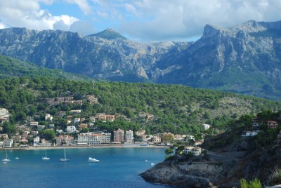
Aponivi at anchor in Puerto de Soller
8,802 miles after we set out from Rhode Island, Aponivi is at rest in Palma. We will remain here until mid-November when a Dockwise ship is scheduled to take on a cargo of sail and power yachts bound for the Caribbean.
To say that I regret sending Aponivi across as cargo, rather than sailing across with the trade winds, is a great understatement. But the decision is not without its benefits. We have been able to remain in the Med far longer than would have been prudent if we were making the westward passage. That passage invariably begins with a positioning run to the Canaries (705 miles southwest of Gibralter and 1,150 miles from here), a trip that should be completed by the end of September. One then sits in the Canaries until nearly December, awaiting the weather window for the westward leg.
And if our boom problem confined us to a smaller area of the Med than we had hoped, we can at least be grateful that we are in an area of great beauty and historical interest, and an ideal location for making repairs. We have been making the most of our surroundings while preparing for the many miles -- from the Caribbean to the northeast -- that still await us.
Our last bit of European sailing adventure took us along the north coasts of two Ballearic Islands, Menorca and Mallorca. These are rugged coasts that look, for the most part, as if they had never been inhabited. There are good reasons for that.
Both coasts, particularly Menorca, are in the path of the tramontana, the Med´s fearsome north wind. Our pilot book states that "the tramontana can be dangerous in that it can arrive and reach gale force in as little as 15 minutes on a calm sunny day with no warning". (Reading further, it appears that the better the weather seems, the more one has to prepare for the worst -- good weather being the harbinger of bad weather.) Once the tramontana begins to blow it lasts¨"at least three days and, on occassion, may last for a week or longer". During winter months, the tramontana "blows for a third of the time" at "force ten (50 knots) or above", a force that would send enormous waves crashing against the shore.
Mallorca´s north coast is a 50 mile long mountain range, the Sierra de Tramontana. Cliffs are a common feature of the European coasts but these are a different order of magnitude. One of the peaks, Puig Major, rises 4,750 feet above sea level, and many others rise half a mile or more from the water's edge. Sailing along the coast, a few small clusters of stone houses -- villages that go back 700 years or more -- can be seen clinging to mountainsides high above sea level. For most of the way there is no other human imprint.
Nature provided one spot on each coast where a sea level village could take root and some harbor facilities could be established. On Menorca, that spot is the fishing village of Fornells, home to 489 hardy souls. On Mallorca, it is the larger harbor of Soller, a hiker's gateway to the mountains and their ancient villages.
We reached Fornells on the fourth of October. As we passed through the narrow entrance to Fornells Bay the village appeared on our right, huddled in a recess that provides some shelter from the north winds. A stone quay extends the curvature of the land, forming a harbor with room enough for local fishing boats and a few visitors to berth side-by-side, one end secuired to the quay and the other to a mooring line.
We were directed to a berth at the outer end of the quay, the only place with room for a boat of our size to maneuver. In a stiff cross wind, Lorraine struggled to attach the mooring line to a deck cleat before the bow was pushed downwind and the rope was pulled from her hands. (This was Lorraine´s job because she would rather do that than handle the controls, and that seems to be for the best in most circumstances.) We managed to secure on our third attempt, with the assistance of a helpful dock attendant and a strong crew member on the neighboring boat.
Our berth gave us a fine view of the bay, where everything beyond the small bit of shoreline occupied by the village remains in its natural state.
In the evening we did what visitors are expected (and happy) to do: we had a seafood paella at a restaurant on the seawall. Reading the English translations on my menu, I came to a dish of "paella with mushroom and rabbi". Concluding that this was a typographical error rather than a vestige of the inquisition, and feeling that my very non-kosher seafood paella provided good cover in any event, I put the menu aside and enjoyed my meal.
On our second and final evening in Fornells a three masted tall ship -- square sails furled on its yardarms -- entered the harbor and dropped anchor. With nothing but woodlands as a backdrop it was a scene straight from the 18th century, when tall ships of the Royal Navy and its adversaries prowled these waters.
In the 1700´s Fornells was essentially an unguarded back door to the heavily fortified harbor at Mahon. When Britain first captured Menorca in 1708, part of its invasion force landed at Fornells. And when Britain recaptured Menorca in 1798, another landing took place here. The need to take Menorca a second time gives rise to an interesting bit of naval, literary, and cullinary history.
By 1756, Britain had controlled Menorca and the prime port of Mahon -- the base of the Royal Navy´s Mediterranean Fleet -- for 48 years. Then, the European powers squared off in what we (in the US) know as the French and Indian War, what Europeans call the Seven Year´s War, and what could well have been called the First World War. One of France´s early objectives was to take Menorca, depriving Britain of a base close to the French coast. A French invasion fleet anchored near Ciutadella, sending 12,000 men ashore. From there, the French marched across the island to Mahon, while its naval escort, 12 ships of the line and five frigates, patrolled the coast.
Only three British Frigates were in Mahon at the time of the invasion, and they were sent to sea rather than risk being captured or trapped by a long blockade. British land forces prepared to make their stand in Fort San Felipe, at the entrance to Mahon Harbor. Bombarded by French artillery, and running low on food and ammunition, the defenders pinned their hopes on the timely return of the mediterranean fleet, then under the command of Admiral John Byng.
Byng´s fleet rached Cape Favaritx -- eight miles east of Fornells and an equal distance north of Mahon -- seven days after the seige began. And then he stopped. By some accounts, he waited while attempting to make contact with the fort´s defenders. While he waited, the French fleet came into view.
The opposing fleets were well matched, 18 British ships with 874 cannons against 17 French ships with 894 cannons. The British fleet gave chase, but only a few ships at the front of its line (Byng´s flag ship not among them) ever came within firing range. After an exchange of cannon fire that inflicted no seriouis damage on either fleet the French maneuvered out of range and Byng maneuvered all the way back to Gibtalter, 450 miles away. While he waited for reinforcements the British troops at Mahon were forced to surrender.
Byng was court martialled for his timidity, and executed by a firing squad. His execution was the inspiration for Voltaire's statement, in Candide, that "it is good to kill an admiral from time to time to encourage the others." Subsequent encounters between the Royal and French navies suggest that there is a lot of truth to that statement..
The French went on to lose the war and to surrender Menorca to the British (along with France´s possessions in Canada, the Gulf coast from Florida to the Mississippi River, and Granada). But France´s occupation of Mahon lasted long enough for the French commander´s chef to perfect a variation of a local sauce and present it at a victory celebration in Paris as "Mahon-esa" -- mayonaise.
We looked forward to seeing more of the tall ship in the daylight. But we awoke the morning to find that it was already gone. We departed a few hours later.
To sail west from Fornells we first had to round Cabo Caballeria, a penninsula that extends two miles northward and ends in a vertical wall of rock 265 feet tall. When we turned west at the end of the penninsula the the tall ship -- now with with 12 sails pulling it downwind -- came into view. A tall ship under a full set of sails is a magnificent site, and one that gets the adrenaline pumping. We "gave chase" and, in seven miles, we were alongside it, shooting a broadside of photographs, before we moved ahead and put distance between us.
With a pleasant westerly wind and smooth seas, we steered into a fair weather anchorage to spend a final night on Menorca before jumping over to Mallorca. We crossed the next day, in a heavy mist that hid Mallorca until we were nearly upon it. As we moved along the coast the mist dissipated, and the mountains came fully into view. At one point a ravine led down to the sea, and the coastal range parted enough to motor into the gap. Mountains on either side of us framed a towering peak a short distance inland.
After 27 miles of coasting we reached Puerto de Soller. A marina, fishing boats, and mooring field fill the eastern half of the circular bay; the more exposed western half is an anchorage. We opted for the anchorage.
Two miles inland, at a slightly higher elevation, the town of Soller is nestled in a valley. Lucia Graves, a writer who grew up in the mountain village of Deia in the decades after World War II, described the valley as a "large bowl with one side broken off where it meets the sea." No roads penetrated the surrounding mountains until well into the 19th Century. Its long isolation had a lasting and largely positive influence. Graves wrote that the valley "was like an island within an island, where life was ruled by the cycles of its natural habitat, and by rituals so ancient that nobody could remember their origin....[O]nly the earth and the water and the elements seemed to govern people's lives...."
Before the 13th century "reconquest" of Mallorca, the Moors who inhabited the area named it Sullier, the Arabic word for "golden Valley". The name is still appropriate. The town of Soller is surrounded by orange and lemon trees. Walking from the sea in any direction, the land slopes upward ever more steeply. The citrus groves give way to olive trees that grow on terraced hillsides, the terraces held in place by row after row of stone walls. The terraces and olive trees are legacies of the Moors, and the tortured trunks of the oldest trees look old enough to have been planted by them. At about 2,00 feet, the snow line, the olive trees end. pine forests rise above that, and then only rock.
During our four days in the area we rowed ashore each morning and spent the days hiking through the mountains. Ancient cobblestone pathways lead from Soller to the hamlets and monastaries that dot the mountainside. Because of the steepness of the terrain, miles of cobblestone stairways were built to aid the traveller. The age of these pathways can be inferred from the date of the first recorded restoration program. In 1400, the church offered "forty days of indulgence" to anyone who helped restore what were already being described as the ancient walkways.
Hiking these paths was as good an activity as can be done on land. At the right elevations, olives hang within reach on every branch. Sheep bells and church bells peal. Streams tumble down the mountains along some of the pathways, and rushing water can usually be heard even when it cannot be seen.
We never tired of our stay but, like the valley life that Graves described , life on board is governed by the elements. During our fifth night in the bay wind charts that we received on our satellite phone warned of a weather change. Gale force winds from the northeast were expected to lash the coast within 36 hours. We resolved to leave in the morning and return to Palma on the sheltered south coast. We spent a mostly sleepless night at anchor. By midnight, swells found there way into the harbor far ahead of the winds thast produced them. With the harbor winds and currents conspiring to keep us broadside to the swells, we rocked through an arc of at least 40 degrees throughout the hours of darkness.
When we took off in the morning we found the progress far smoother than our night at anchor. Our two exciting seasons of voyaging-- the Atlantic crossing; the crossings of the Irish Sea, the English Channel, and the Bay of Biscay; the 25 foot tides and fierce overfalls of the British and Brittany coasts; the exciting run through the Strait of Gibralter -- ended with a quiet day sail. When the gale arrived on the north coast, we were snug in our well protected berth on the south coast.
For those who joined us during our voyage, we must do it again sometime. As for the blog, it shall return, with the Caribbean saga, in early December. Stay tuned for any bulletins.
Report from Menorca
01 October 2010 | Ciutadella
H. Veisz
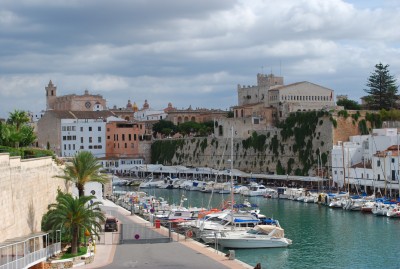
Ciutadella Harbor
With our permanant rigging repairs still in the planning stage, and awaiting our return to Palma, we are taking baby steps across the Ballearic Islands. Fortunately, baby steps are all that have been needed to reach some fine places. Our present location, the little harbor of Ciutadella on the west coast of Menorca (about 120 miles southeast of Barcelona), requires some re-rating of prior stops to leave room at the top.
After departing from Palma we went 47 miles around the coast of Mallorca to Puerto Colom, where we anchored in its well sheltered harbor. Peurto Colom is a world apart from Palma. In lieu of Palma's royal palace and other monumental buildings, there are two modest fishing villages, both very pleasant to look at and to stroll through. In lieu of the megayachts tied up at Palma's top tier yacht club and marinas, a fleet of traditional two man fishing boats were tied side-by-side at the stone quays. These open boats, with lateen rigs and small engines, still bring in the catch and, with their gleaming white hulls and carved wooden prows, are a delight to behold. We spent two night enjoying the surroundings, but the best was yet to come.
Another 24.5 miles of coastal sailing brought us to the northeast tip of Mallorca and a spectacular little anchorage called Cala Molto. The coasts of the Ballearic Islands are surrounded by calas, where indentations in the cliffs, and clear turquoise waters, create some of the most beautiful anchorages imaginable. The best of these, like Cala Molto, have a white sand bottom, ten to twenty feet of depth, just enough room for two or three boats to swing at anchor, and an absence of any man-made detractions.
As we arrived at Cala Molto Lorraine and two British friends were at the bow, ready to drop the anchor. Nervous about running aground on sands that seemed closer that our 6 1/2 foot draft, they were surprised to see more than 20 feet of chain run out before the anchor hit bottom. And when it did, the anchor and chain (including the 60 extra feet deployed to assure a good hold through the night) remained clearly visible on the bottom. With the anchor set, the Brits and I donned snorkel gear and jumped in, joining schools of fish at the edges of the Cala, where the sands meet a ring of sea grass. After a swim, we dined in the cockpit, enthralled by the surroundings and feeling fortunate to be one of the two boats that found room in this little piece of paradise.
Ciutadella, only 24 miles away, was our next destination. We arrived September 22 and have yet to leave. (We plan to tear ourselves away tomorrow.) The entrance to Ciutadella's narrow inlet is marked by a lighthouse on the port side, and a small 17th century fort, in perfect condition, on the starboard side. A short distance beyond the entrance the inlet takes a slight bend to starboard. As you make the turn Ciutadella -- a town of 17th and 18th century architectural masterpieces, perched atop a cliff, overlooking an ancient quay -- suddenlly appears. At the quay, there is room for a half dozen cruising boats to tie up, bow or stern to, among the town's fishing boats and small fleet of local pleasure craft. The tables of seafood restaurants spill out onto the quay from back rooms that are carved out of the rock.
A bit of local history helps appreciate Ciutadella and its surrroundings. From 1600 to 1200 BC, Ciutadella was a Phoenician port. When the Phoenicians arrived the island had already been settled by a people that lived in caves surrounding some of the island's finest calas (notably Cala Covas and Cala Morell) and that constructed inland buildings -- used as community tombs -- from massive blocks of stone. On a bike ride through the island's interior we came upon one such structure (the 14 by 6.5 meter Naveta des Toudons) that has stood for over 3,000 years. While admiring the construction I wondered why it never dawned on the inhabitants to live in their stone buildings and leave the dead in the caves. And then I concluded that -- from caves to condominiums -- the lure of waterfront property has always induced people to put up with deficiencies in their accomodations.
On another bicycle ride, to Cala Morell, we saw both caves and condos (or condo-like homes) on the surrounding rock. One of the caves has been converted into a restaurant, appropriately named Trogladitas, with an outdoor dining area perched on a ledge overlooking the water. -- a cave that any bronze age real estate agent would have loved to list. Here, I must confess, I rely on Lorraine for any insight into Trogladitas' interior design. Having suffered a mishap on my final approach to the restaurant, I was sprawled next to my bike on the pavement above the restaurant while Lorraine went below to arrange a ride to a private clinic in Ciutadella, where a half dozen stitches repaired the damage to my right leg. My son responded to news of my injury with characteristic concern, stating in an e-mail that he was "glad [I] did not require the traditional sailor's wooden peg leg", and observing that "a small scar from each voyage is to be expected." But I digress.
After the Phonecians came and went the Greeks arrived, followed by the Carthagenians and a few b-list conquerors. The, in about 100 BC, Menorca was incorporated into the Roman Empire, and Ciutadella became a Roman port city. In 903 AD the Moors invaded and made Menorca a part of the Cordoba Caliphate. Alfonso III of Aragon dispossessed the Moslem population in 1287, completing the reconquest of Iberia. Menorca then became part of the Kingdom of Mallorca, which was merged into the kingdom of Aragon 50 years later. The present city of Ciutadella then began to take shape.
Work on Ciutadella's cathedral began in 1300 and was completed 62 years later. It had to be rebuilt more than once, but stands today much as it did in 1362 -- an imposing structure at the heart of the city. Whatever architectural sins may have been committed during that period were wiped clean in 1558, when Turkish corsairs entered the harbor and leveled the town. The raid apparently did little lasting damage to the fortunes of the island's aristocracy. When fort San Nicholai was built at the harbior entrance the security it provided ignited an aristocratic building boom at a time of architectural greatness. During the 1600's and 1700's urban palaces sprouted throughout Ciutadella in (and here I rely on the guidebooks) Italian Renaissance, Italian Baroque and neo-classical styles. And then another invasion -- by the Royal Navy -- froze Ciutadella in its golden age.
Britain occupied Menorca for much of the 18th century, taking it by force -- without any damage to Ciutadella -- in 1708, losing it twice, and regaining it twice. Britain ceded it back to Spain for the final time in 1802. Britain took it the first time in the name of the Hapsberg's dynasty's Charles III, a would be Spanish king who Britain backed in the War of Spanish Succession. But Britain's attachment to Menorca outlived its enthusiasm for Charles, and his interest in the Spanish throne. It kept Menorca (as well as Gibralter, captured at the same time) long after the war ended and Charles rode off into the sunset. The object of Britain's affection was Mahon, a larger harbor on the far side of the island that could accomodate the largest warships of the age, and where as many as many as 32 Royal Navy ships found shelter the same time. So, in 1722, Britain shifted the seat of government from Ciutadella to Mahon, and the business of supplying and maintaining Britain's Mediterranean fleet drew the island's commercial activity to Mahon. The nobility and church officials who were left behind in Ciutadella were not wholly neglected, and certainly not abused, but the engines of growth and change had been moved elsewhere.
A few days before my accident, Lorraine and I rode our bicycles inland, watching the works of prior centuries unfold around us. We cycled out of Ciutadella on the Cami Vell (the old road in Catalan) a country lane that was once the major road to and from Ciutadella , and that is a legacy of the early British years. Two and a half miles out of town we passed the 3000 year old Naveta des Toudons. After seven miles, our route departed from the Cami Vell and continued along the far rougher and far older Cami Reial. A tour book describes the Cami Reial as a "Roman, Arab and Medieval" road, and it looks its age. Indeed, "road" is an overly generous description. The Cami Reial becomes a narrow stone path just wide enough to walk alongside a bike. It descends sharply to the base of a canyon, and proceeds a considerable way along the canyon floor, between 80 meter tall white cliffs, before it smooths out to any degree. The scenery was unquestionably beautiful but the going was rough. A guidebook describes this portion of the Cami Reial under the heading "a poc a poc" (little by little). This, the book explains, "is an expression used in Menorca to explain how to go through life." And it was the only way we could get through the Cami Reial..
As we progressed "little by little" it became clear that we could not retrace our steps before darkness. Having ruled out going backwards, we plunged onwards and, as the canyon walls receded, we reached an 18th century farmhouse where Lorraine discussed our options with the women of the farm. (Lorraine, by this point, was well passed mere fluency in Spanish. As we travelled along the south of Spain she moved on to the Catalan dialect, and then the Menorcan version of the Catalan dialect.) As I stood silently at the edge of the path Lorraine engaged in an animated, obviously enjoyable, and utterly incomprehensible conversation. Translating on a need to know basis, Lorraine advised me that our best option was to ride onward to the town of Ferreries (perched atop a hill, of course) where it seemed possible to catch a bus back to Ciutadella, with our bicycles stored in the luggage compartment beneath the seats. It was not quite that simple.
Busses that stopped at Ferreries were of the interstate varitey, with cavernous -- and empty -- luggage compartments. But, for reasons a driver tried to explain, bicycles were banned. We began to collapse our folding bikes to luggage sized parcels. If we had our carrying bags to put them in the collapsed bicycles would simply have become two pieces of luggage and that would be the end of it. Without the bags we were getting into serious questions. Is a folding bicycle still a bicycle when it is folded? Is a suitcase sized collection of bicycle parts a bicycle? Does an exposed pedal pose a continuing threat because of its inherent bikey-ness?
As the time for our bus to arrive drew near, and our bicycle fragments were reaching their minimum size, the owner of a restaurant where we had stopped earlier for a beer -- and whose outdoor dining area we were now using as our workshop -- approached in an animated state. In New York he might well have been coming to chase us from his doorstep. Here, he was applying another part of the Menorcan philosophy for going through life: not just little by little, but kindness by kindness. We have not heard that part of the philosophy expressed, nor have we seen it in print, but we have seen it demonstrated by Menorcans whenever an opportunity arose.
Having sized up our situation, he urged us to stay put while he ran back to the restaurant for a pair of sacks that made fine improvised carying bags. He then ran back for tape to complete the transformation from bicycles to luggage, spurning Lorraine´s offer of compensation with a clear ¨no dinero, no dinero¨that even I could understand.
His efforts no doubt made the difference. As I was loading my package under the bus driver´s gaze a bit of tire emerged. I felt exposed, like an Amish woman who carelessly showed a bit of ankle at the church door. He gave me an icy stare, and spent a few secends weighing the gravity of the offense, but let it pass.
Postscript: After beginning this blog entry we have moved on from Ciutadella to another fantastic cala where we spent two nights at anchor. We then moved further along the coast to Fornells, where we tied up at the quay of small fishing village.
All is well.
Gibralter to Mallorca: A Good Start and then ...
19 September 2010 | Palma de Mallorca
H. Veisz
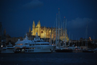
View from Aponivi at Palma de Mallorca
We left Gibralter at 3:00 pm on the seventh of September, bound for Al Merimar, a Spanish port 130 miles to the east. Throughout the afternoon and night we had strong westerly winds, propelling us at an average speed in excess of eight knots. We had Al Merimar off the beam well before daylight and decided to press on. By 1:30 in the afternoon we had rounded Cabo de Gata, one of the major headlands on the coast, and dropped anchor in Puerto Genoves, a small bay ringed by trees and fields in the foreground, mountains in the background, and little else. Somehow, this beautiful spot managed to avoid any development other than a few private homes on a nearby hillside. Having covered 166 miles in about 22 hours, and anchored in a bit of paradise, we were well pleased.
After an afternoon and evening in Peurto Genoves we raised anchor at 4:00 am on the ninth in order to reach our next destination, Cartagena, by mid-afternoon. The 75 miles to Cartagena went smoothly, and we tied up at a prime berth along the town's sea wall at 3:45. Cartagena has a long history, having been an important port for the Phonecians, Cartheginians, Romans, and so on. The port is entered through a narrow slit in the mountains that run along the coast, and each conqueror left fortifications that appear, one above another, as you pass through the slit into the broad harbor that lies beyond it. Cartagena's centuries as a Roman port are evidenced by a Roman theater, excavaqted over the last two decades, that was constructed more than 2000 years ago. Today, it is very much intact and easily accessible, only a ten minute walk from where we were tied up. There will be more about this beautiful little city in a future blog. The major event during the period of this report happened on the next leg, a 147 mile passage from Cartagena to Ibiza.
We set out for Ibiza in the afternoon of 9/11. By midnight we had covered 82.5 miles and were proceeding, under power, in a light breeze and light chop. As daylight neared, the trip was progressing smoothly. With single digit winds, we continued to motor and the autopilot was doing most of the steering. The main function of the person on watch was to look out for other traffic -- cruise ships and cargo vessels regularly criss-crossed our path -- and adjust our course when needed to avoid close encounters at sea. Avoiding other vessels was no problem; the problem was developing, imvisibly, on our own boat.
Scanning for traffic in the conditions prevailing on that passage is generally done standing up at the trailing edge of the hard dodger. I was on watch in the early hours of the twelth, spending long periods in that position. As I ducked under the dodger for a short break the boom -- a 22 foot long metal beam holding the furled mailsail -- came crashing down on the dodger, its aft end plummeting through the space that my head had occupied seconds earlier.
The boom is held up by two devices: a line (the topping lift) runs from the top of the mast to a 1/4 inch diameter steel rod bolted at both sides to the end of the boom, and a heavy metal strut (the boom vang) that runs at an angle from the base of the mast to a point on the underside of the boom. The quarter inch steel rod fractured first, sending the topping lift flying. As the full weight of the boom came down on the vang it immediately buckled and broke in half. A moment earler, the boom would have landed on me at the same instant as the boom, and I would have fared no better. As it was, the hard dodger withstood the impact, and I was unhurt. Lorraine, asleep in the cabin, was out of harm's way at the critical moment, but she had spent an equal share of the night in the danger zone.
With 25 miles still to go, we lashed down the boom, to prevent it from sliding around and causing further damage, and motored on to Ibiza -- the nearest port as well as the intended destination. Once in Ibiza we unbolted the remnants of the failed parts and put new lashings on the boom to raise it from the dodger and keep it immobile. In that fashion, we motored to Mallorca, a few days later, and began work with a rigging engineer on a more permanant cure for our problems.
Between work sessions and time spent on board waiting for workers we have managed to see some of Palma. Fortunately, some of its most beautiful structures -- notable the Cathedral La Sue on which work began in 1230 -- are visible from the marina and only a few minutes away on foot. Bellver Castle, a 13th century fortress, can be seen on a hill overlooking the bay. And the shoreline around the marina has other delights, ranging from tapas bars in narrow alleyways to a royal palace that was built by the moors and that has been occupied by Spanish Kings since the moors were evicted some 800 years ago.
With tejmporary fixes in place, and a go-ahead that we received from our rigging engineer after an inspection yesterday, we plan to leave Palma today and head to an anchorage on the other side of the island. From there, we will take the 57 mile hop to the port of Mahon on Minorca -- the third of the Ballearics and the only one we have not yet seen. After that, it is back to Palma for more permanant repairs.
Gibralter Rocks
07 September 2010 | Gibralter
H. Veisz
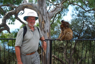
Howard (on the left) and Ape Friends
The first ironclad sign of the African coast consisted of four flashes of light. At 3:30 on Saturday morning (4 Sept.) we were nine miles southeast of Trafalgar, the scene of the great 1805 naval battle in which Nelson caught up with and destroyed the combined French and Spanish fleet, and we were heading for the Strait of Gibralter. (We were in fact following the intended path of the ill fated fleet, on a run from the Bay of Cadiz to the Med.) Eighteen miles to our south, on the northwest tip of Moracco, the Cap Spartel lighthouse was emitting its signiture four flashes every 20 seconds -- a pattern, according to our chart, that should be visibe for 30 miles under ideal conditions. We scanned the horizon for about five minutes and there it was, with the faint glow of Tanger a few miles to its east.
At this point, the gap between Spain and Morocco begins to narrow like a funnel. For the last ten miles (before the Bay of Gibralter opens to the north and the coat of Morocco drops off to the south) the continents are only eight miles apart.
At the time we spotted Cap Spartel, we still had 30 miles to go though the funnel before emerging at Gibralter. And a memorable 30 miles it was to be. When we left Rota (in the Bay of Cadiz) at 7:30 Friday evening we knew that the leventer -- an easterly wind -- would be blowing in the Strait. We checked two forecasting services. One predeicted peak winds of 14 knots, the other 19 knots. They were wrong.
By 4:46 in the morning, the apparent wind began to exceed 30 knots. (As our speed had slowed to a crawl, the true wind speed was not very much less.) By 6;30 the apparent wind was up to 34 - 35 knots, and by 7:30 it had hit 40 knots. At that point, with the wind on our nose, we were barely sustaining two knots of headway. As we entered the narrowest ten miles the wind abated to 30 knots, or slightly less, but it still took three hours to cover the ten miles.
The boat was pitching a good bit, and each drop of the bow sent spray flying across the cockpit and into the face of the person at the wheel. As the hours went on, and we became coated with salt, attempting to duck beneath each spray hardly seemed worth the effort, and we saved that exertion for the largest waves.
During this period, we stayed within two miles of the Spanish coast, in a strip between the shore and the "traffic seperation zone" that contained designated inbound and outbound lanes for commercial traffic. Even so, a string of lights along the Moroccan coast was plainly visible. Between us and that shore a steady procession of tankers and other cargo ships made their way through the strait. On our AIS screen (which tracks the location and movement of other vessels) the icons for inbound shipping were lined up end-to-end, making an unbroken line.
At 11:30, we emerged from the Strait and, up ahead, the Rock of Gibralter came into view. The winds continued to abate. But they were much in evidence at the Rock itself, where clouds formed at the peak and streamed downwind from there. Later, when Aponivi was tied up at Marina Bay, and we walked along a path near the top of the Rock, we could see the cloud form where the wind swept over a crest directly ahead of us, and then walked only a few feet below the base of the cloud.
This is our second visit to Gibralter by sailboat, and it has lost none of its beauty or interest in the intervening ten years. On the Rock above the town, hundreds of Barbary Apes continue to frolic. Completely at ease with people, they are happy to sit next to you, or simply ignore you while you gawk an arms length away. But beware of plastic bags. Signs warn visitors that the apes know that plastic bags are likely to contain food, and will rip them from your hands. We watched one person prove the point. She walked out of a building with a bag of fruit, and half a dozen apes went, well ape, tore apart the bag and ran off with the goods.
Down below are layers of well preserved history: seige tunnels from which British forces defended Gibralter from the Spanish during the Great Seige of the 1790's; Rosia Bay, where Nelson's Victory docked -- victorious but heavily damaged -- after the Battle of Trafalgar; and World War II tunnels, where an entire base, including a hospital and Spitfire assembly plant, was built underground.
At the base of the Rock the town of Gibralter retains an attractive historic core, within fortress walls that have stood for hundreds of years. It also appears to remain a place of great harmony. In this tiny enclave are four synagogues, a number of mosques, and a number of churches -- all of which apper to have full congregations that coexist quite nicely. If there is any hostility, it was undetectable on this trip.
We are about to untie and head east, planning to get to Ibiza on about September 12 or 13.
| Vessel Name: | Aponivi |
| Vessel Make/Model: | Apogee 50 |
| Hailing Port: | New York, NY |
| Crew: | Howard and Lorraine Veisz |
Gallery not available
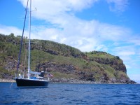
Who: Howard and Lorraine Veisz
Port: New York, NY