SY Angel of London
A government which robs Peter to pay Paul, can always count on the support of Paul. – George Bernard Shaw
Crew thoughts...

Who: Barbara and Tom
Port: New York, NY
CONTENTS
02 April 2012 | Marsh Harbor, Abacos.
12 January 2012 | Charleston
29 December 2011 | Windham Vermont
15 December 2011 | Charleston, SC
21 November 2011 | Charleston
20 October 2011 | Braunschweig, Germany
16 October 2011 | Köln, Germany
03 October 2011 | Porthsmouth VA
29 August 2011 | Westbrook, CT
14 August 2011 | Westbrook, CT
10 June 2011 | South Coast of Connecticut
18 February 2011 | George Town, Exumas
04 February 2011 | George Town, Exumas
01 February 2011 | Mayaguana
23 January 2011 | Puerto Plata
15 January 2011 | Guaiana, Puerto Rico
03 December 2010
24 November 2010 | USVI
20 November 2010
11 November 2010 | St Martin
Not somewhere in the Pacific
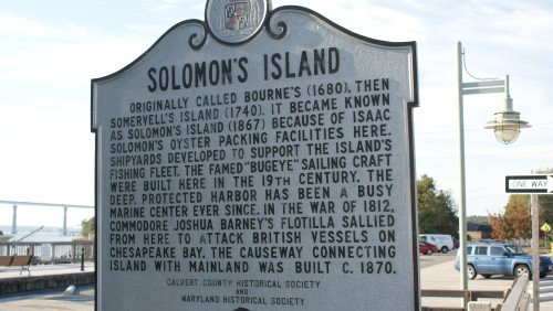
15 October 2008 | 38 19'N:76 25'W, Solomon's Island, MD (Just inside the mouth of the Pautuxent River)
TRC (Clear, cool nights and warm days)
We sure need good charts here. Lots of shallow water and Barbara really has the skills. For those of you that don't think about this....a chart is a "road map" for mariners. It tells us where they are, where we can sail safely, and delineates areas to avoid by describing the surface under the water. Our charts (paper and electronic) provide a wealth of data right down to the names of buoy's, currents and old wrecks. These hundreds of bits of information are readily available (for mental digestion) telling us virtually everything we need to know to plan routes and navigate safely. Our electronic charts interface with our radar and autopilot. We can track up to 10 other vessels at the same time using the electronic chart plotter with its output superimposed on the radar.
What is striking about the Chesapeake are the vast areas of seemingly deep water stretching for miles and miles. Clearly the mariners that came before use did not always have the benefit of accurate charts. Earlier charts were artistic and far less informative, depending on the state of exploration or survey work at a given time.
Because the Chesapeake Bay has been so important to the history of Maryland and the USA , charts have played a central role as well. From the seventeenth century forward charts were the key to economic or naval power. Charts were indispensable to Maryland's early vessels of commerce and trade, such as the tobacco ships which transported the region's cash crop to market in Europe. They were also essential to both the British and American navies during the Revolutionary War and the War of 1812. Those days sailors needed to know the location of shoals, conditions of the bottom, and the ways of tide and current to maneuver their vessels during battles on the Chesapeake and its tributaries.
Adapted from "Charting the Chesapeake" 1950-1990
Comments
| Vessel Name: | Angel of London |
| Vessel Make/Model: | Oyster 47 |
| Hailing Port: | New York, NY |
| Crew: | Barbara and Tom |
| About: | |
| Extra: | |
| Home Page: | www.angeloflondon.de |
Gallery not available
Crew thoughts...
Who: Barbara and Tom
Port: New York, NY