


- PHOTOS:
- Dec 16, 2008 - May 21, 2009
- Mar 17, 2008 - Dec 15, 2008
- Nov 01, 2007 - Mar 16, 2008
- Our SC35 Sailboat: PRUDENCE
- SELECTED BLOGS
- Jan'05: The Idea
- May'05: First Cruise - Belize
- Aug'05: Buying Ashiya
- Oct'05: School in St. Vincent
- Nov'05: Ocracoke on Ashiya
- Jul'06: Long Trip on Ashiya
- Oct'06: Prudence Comes Home
- Nov'07: First Night Offshore
- Nov'07: Offshore Take Two
- Nov'07: Gulf Stream Crossing
- Dec'07: Green Turtle Cay
- Dec'07: Lynyard Cay
- Dec'07: Warderick Wells Cay
- Jan'08: George Town
- Jan'08: Life without a Fridge
- Jan'08: Mayaguana Island
- Jan'08: Turks & Caicos
- Jan'08: Dominican Republic
- Jan'08: Down the Waterfalls
- Feb'08: Puerto Rico
- Feb'08: Starter Troubles
- Feb'08: Vieques
- Mar'08: Finally Sailing Again
- Mar'08: Trip So Far
- Mar'08: Hiking Culebra
- Mar'08: Kayak & Snorkel I
- Mar'08: Teak and Waterspouts
- Mar'08: Kayak & Snorkel II
- Mar'08: Bottom Cleaning
- Apr'08: Culebra Social Life
- Apr'08: Culebra Routine
- Apr'08: Culebra Beaches
- Apr'08: Culebrita
- Jun'08: Kayak & Snorkel III
- Jun'08: Kayak & Snorkel IV
- Jun'08: Manta Ray
- Jun'08: Sea Turtles
- Jul'08: Cost of Cruising
- Jul'08: Busy Week in Culebra
- Jul'08: Getting to Land
- Jul'08: Leatherback Boil
- Jul'08: Fish and Volcano Dust
- Aug'08: Teaching Algebra
- Sep'08: Culebra Card Club
- Oct'08: Kayak & Snorkel V
- Oct'08: Prep for Hurricane
- Oct'08: Hurricane Omar
- Oct'08: Fish and Sea Glass
- Oct'08: Waterspouts
- Dec'08: Hurricane Season Ends
- Dec'08: Culebra to St. Martin
- Jan'09: Antigua Part 1
- Feb'09: The Saints
- Feb'09: Visiting Dominica
- Mar'09: Antigua Part 2
- Apr'09: Antigua to Bermuda
- May'09: Bermuda to Norfolk
- FULL LIST of Blog Entries
SailBlogs Friends


15 July 2009
14 July 2009
15 June 2009
14 June 2009 | Annapolis, MD
13 June 2009
12 June 2009
11 June 2009
10 June 2009 | Little Creek Marina, Norfolk, VA, USA
04 June 2009 | Little Creek Marina, Norfolk, VA, USA
31 May 2009 | Little Creek Marina, Norfolk, VA, USA
29 May 2009 | Little Creek Marina, Norfolk, VA, USA
26 May 2009 | Little Creek Marina, Norfolk, VA, USA
25 May 2009 | Little Creek Marina, Norfolk, VA, USA
13 May 2009 | through 21-May-2009
13 May 2009 | through 21-May-2009
12 May 2009 | St George's Town, Bermuda
11 May 2009 | St George's Town, Bermuda
07 May 2009 | St George's Town, Bermuda
04 May 2009 | St George's Town, Bermuda
21 April 2009 | through 02-May-2009
7:00 AM: IKE is a Compact Little Ball of Energy
05 September 2008 | Culebra, Puerto Rico
CURRENT LOCATION: Anchored in Ensenada Honda, near town on Culebra
18 18.326' N, 065 17.979' W
The morning has been a flurry of mouse clicks. I awoke at 6AM, one hour after the release of the latest NOAA update. Believe me, I am as anxious as anyone for this information, but I was up until midnight reading the 11PM update last night. Then, of course, we got more rain. After yet another late night round of closing hatches, it was tough to get back to sleep. (As a quick aside from the more threatening weather situation, Sheryl and I must say that we are getting a little weary of being damp ALL the time). If it is not rain, then it is relatively high humidity. For more reasons than one, we are currently begging for winter to hurry up and arrive.
Now, back to IKE. With lots of new data to consider, let's take a look at current conditions:
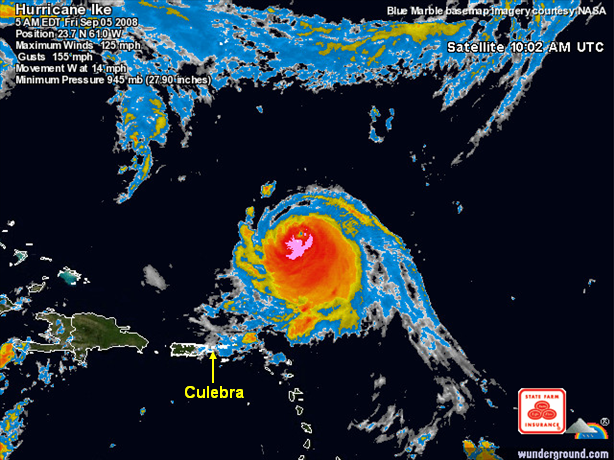
IKE (5:00 AM 9/05)
Status: CAT 3 HURRICANE
Max winds: 125 MPH
Range of hurricane force winds: OUTWARD UP TO 35 MILES
Range of tropical storm force winds: OUTWARD UP TO 105 MILES
Position: 23.7 N, 61.0 W
Movement: WSW at 15 MPH
Distance from us: ~ 460 MILES from CULEBRA
Conditions at weather buoy 41043 (~190 miles north of Culebra): wind=4kts; gusts=6kts
As expected, IKE has weakened to a Cat 3 hurricane. Of course, that is like saying that the panther perched on the tree branch above you only weighs 125 lbs, rather than 140 lbs. Not to look a gift horse in the mouth, though, we will take any evidence of a weaker storm and hope for continued trends in that direction. In addition to weakening intensity, the storm is smaller than it was yesterday. Combine that with the fact that it made some good northward progress and things are looking quite good for us. However, I should note that the movement has shifted to the westsouthwest. The key question is how much southing will IKE make in the near future?
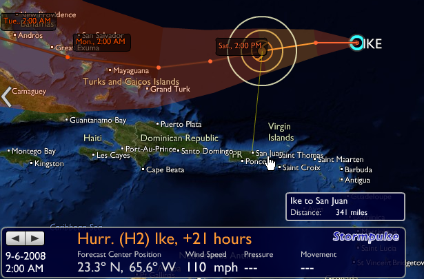
Presently, it is dead calm here (another mirror surface on the bay), and exceptionally calm at our early warning weather buoy out in the Atlantic to our north. Regular data from that buoy along with satellite images will define the next two days for us. According to the forecast, IKE should be around 300 miles due north of us by tomorrow afternoon. That means that we may be able to breathe a slight sigh of relief on Sunday. Hopefully, there will be a little downtime before we have to do it all again with Tropical Storm JOSEPHINE (currently 2,000 miles from Culebra). The return of sunny skies and tradewind breezes for a few days would certainly be welcomed by the crew of Prudence.

18 18.326' N, 065 17.979' W
The morning has been a flurry of mouse clicks. I awoke at 6AM, one hour after the release of the latest NOAA update. Believe me, I am as anxious as anyone for this information, but I was up until midnight reading the 11PM update last night. Then, of course, we got more rain. After yet another late night round of closing hatches, it was tough to get back to sleep. (As a quick aside from the more threatening weather situation, Sheryl and I must say that we are getting a little weary of being damp ALL the time). If it is not rain, then it is relatively high humidity. For more reasons than one, we are currently begging for winter to hurry up and arrive.
Now, back to IKE. With lots of new data to consider, let's take a look at current conditions:
IKE (5:00 AM 9/05)
Status: CAT 3 HURRICANE
Max winds: 125 MPH
Range of hurricane force winds: OUTWARD UP TO 35 MILES
Range of tropical storm force winds: OUTWARD UP TO 105 MILES
Position: 23.7 N, 61.0 W
Movement: WSW at 15 MPH
Distance from us: ~ 460 MILES from CULEBRA
Conditions at weather buoy 41043 (~190 miles north of Culebra): wind=4kts; gusts=6kts
As expected, IKE has weakened to a Cat 3 hurricane. Of course, that is like saying that the panther perched on the tree branch above you only weighs 125 lbs, rather than 140 lbs. Not to look a gift horse in the mouth, though, we will take any evidence of a weaker storm and hope for continued trends in that direction. In addition to weakening intensity, the storm is smaller than it was yesterday. Combine that with the fact that it made some good northward progress and things are looking quite good for us. However, I should note that the movement has shifted to the westsouthwest. The key question is how much southing will IKE make in the near future?
Presently, it is dead calm here (another mirror surface on the bay), and exceptionally calm at our early warning weather buoy out in the Atlantic to our north. Regular data from that buoy along with satellite images will define the next two days for us. According to the forecast, IKE should be around 300 miles due north of us by tomorrow afternoon. That means that we may be able to breathe a slight sigh of relief on Sunday. Hopefully, there will be a little downtime before we have to do it all again with Tropical Storm JOSEPHINE (currently 2,000 miles from Culebra). The return of sunny skies and tradewind breezes for a few days would certainly be welcomed by the crew of Prudence.
| Vessel Name: | Prudence |
| About: |
Gallery not available
- PHOTOS:
- Dec 16, 2008 - May 21, 2009
- Mar 17, 2008 - Dec 15, 2008
- Nov 01, 2007 - Mar 16, 2008
- Our SC35 Sailboat: PRUDENCE
- SELECTED BLOGS
- Jan'05: The Idea
- May'05: First Cruise - Belize
- Aug'05: Buying Ashiya
- Oct'05: School in St. Vincent
- Nov'05: Ocracoke on Ashiya
- Jul'06: Long Trip on Ashiya
- Oct'06: Prudence Comes Home
- Nov'07: First Night Offshore
- Nov'07: Offshore Take Two
- Nov'07: Gulf Stream Crossing
- Dec'07: Green Turtle Cay
- Dec'07: Lynyard Cay
- Dec'07: Warderick Wells Cay
- Jan'08: George Town
- Jan'08: Life without a Fridge
- Jan'08: Mayaguana Island
- Jan'08: Turks & Caicos
- Jan'08: Dominican Republic
- Jan'08: Down the Waterfalls
- Feb'08: Puerto Rico
- Feb'08: Starter Troubles
- Feb'08: Vieques
- Mar'08: Finally Sailing Again
- Mar'08: Trip So Far
- Mar'08: Hiking Culebra
- Mar'08: Kayak & Snorkel I
- Mar'08: Teak and Waterspouts
- Mar'08: Kayak & Snorkel II
- Mar'08: Bottom Cleaning
- Apr'08: Culebra Social Life
- Apr'08: Culebra Routine
- Apr'08: Culebra Beaches
- Apr'08: Culebrita
- Jun'08: Kayak & Snorkel III
- Jun'08: Kayak & Snorkel IV
- Jun'08: Manta Ray
- Jun'08: Sea Turtles
- Jul'08: Cost of Cruising
- Jul'08: Busy Week in Culebra
- Jul'08: Getting to Land
- Jul'08: Leatherback Boil
- Jul'08: Fish and Volcano Dust
- Aug'08: Teaching Algebra
- Sep'08: Culebra Card Club
- Oct'08: Kayak & Snorkel V
- Oct'08: Prep for Hurricane
- Oct'08: Hurricane Omar
- Oct'08: Fish and Sea Glass
- Oct'08: Waterspouts
- Dec'08: Hurricane Season Ends
- Dec'08: Culebra to St. Martin
- Jan'09: Antigua Part 1
- Feb'09: The Saints
- Feb'09: Visiting Dominica
- Mar'09: Antigua Part 2
- Apr'09: Antigua to Bermuda
- May'09: Bermuda to Norfolk
- FULL LIST of Blog Entries
SailBlogs Friends