


- PHOTOS:
- Dec 16, 2008 - May 21, 2009
- Mar 17, 2008 - Dec 15, 2008
- Nov 01, 2007 - Mar 16, 2008
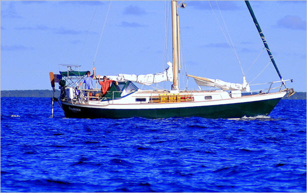
- Our SC35 Sailboat: PRUDENCE
- SELECTED BLOGS
- Jan'05: The Idea
- May'05: First Cruise - Belize
- Aug'05: Buying Ashiya
- Oct'05: School in St. Vincent
- Nov'05: Ocracoke on Ashiya
- Jul'06: Long Trip on Ashiya
- Oct'06: Prudence Comes Home
- Nov'07: First Night Offshore
- Nov'07: Offshore Take Two
- Nov'07: Gulf Stream Crossing
- Dec'07: Green Turtle Cay
- Dec'07: Lynyard Cay
- Dec'07: Warderick Wells Cay
- Jan'08: George Town
- Jan'08: Life without a Fridge
- Jan'08: Mayaguana Island
- Jan'08: Turks & Caicos
- Jan'08: Dominican Republic
- Jan'08: Down the Waterfalls
- Feb'08: Puerto Rico
- Feb'08: Starter Troubles
- Feb'08: Vieques
- Mar'08: Finally Sailing Again
- Mar'08: Trip So Far
- Mar'08: Hiking Culebra
- Mar'08: Kayak & Snorkel I
- Mar'08: Teak and Waterspouts
- Mar'08: Kayak & Snorkel II
- Mar'08: Bottom Cleaning
- Apr'08: Culebra Social Life
- Apr'08: Culebra Routine
- Apr'08: Culebra Beaches
- Apr'08: Culebrita
- Jun'08: Kayak & Snorkel III
- Jun'08: Kayak & Snorkel IV
- Jun'08: Manta Ray
- Jun'08: Sea Turtles
- Jul'08: Cost of Cruising
- Jul'08: Busy Week in Culebra
- Jul'08: Getting to Land
- Jul'08: Leatherback Boil
- Jul'08: Fish and Volcano Dust
- Aug'08: Teaching Algebra
- Sep'08: Culebra Card Club
- Oct'08: Kayak & Snorkel V
- Oct'08: Prep for Hurricane
- Oct'08: Hurricane Omar
- Oct'08: Fish and Sea Glass
- Oct'08: Waterspouts
- Dec'08: Hurricane Season Ends
- Dec'08: Culebra to St. Martin
- Jan'09: Antigua Part 1
- Feb'09: The Saints
- Feb'09: Visiting Dominica
- Mar'09: Antigua Part 2
- Apr'09: Antigua to Bermuda
- May'09: Bermuda to Norfolk
- FULL LIST of Blog Entries
SailBlogs Friends


15 July 2009
14 July 2009
15 June 2009
14 June 2009 | Annapolis, MD
13 June 2009
12 June 2009
11 June 2009
10 June 2009 | Little Creek Marina, Norfolk, VA, USA
04 June 2009 | Little Creek Marina, Norfolk, VA, USA
31 May 2009 | Little Creek Marina, Norfolk, VA, USA
29 May 2009 | Little Creek Marina, Norfolk, VA, USA
26 May 2009 | Little Creek Marina, Norfolk, VA, USA
25 May 2009 | Little Creek Marina, Norfolk, VA, USA
13 May 2009 | through 21-May-2009
13 May 2009 | through 21-May-2009
12 May 2009 | St George's Town, Bermuda
11 May 2009 | St George's Town, Bermuda
07 May 2009 | St George's Town, Bermuda
04 May 2009 | St George's Town, Bermuda
21 April 2009 | through 02-May-2009
A Final Weather Analysis, and We’re Off …
20 April 2009 | Jolly Harbour, Antigua
CURRENT LOCATION: Anchored in Mosquito Cove, just outside the entrance to Jolly Harbour, Antigua
17 04.505' N, 061 53.541' W
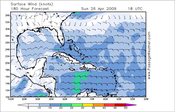
The time has come for us to wave goodbye to Antigua and to the Caribbean. Our weather analysis suggests that now is as good a time as any to head northward. We've gathered data from a variety of sources, including our good friend NOAA, but this time we have found that the most concise presentation of forecasted wind and wave conditions to suit our needs was to be found at PassageWeather.com. Their weather images look something like this:
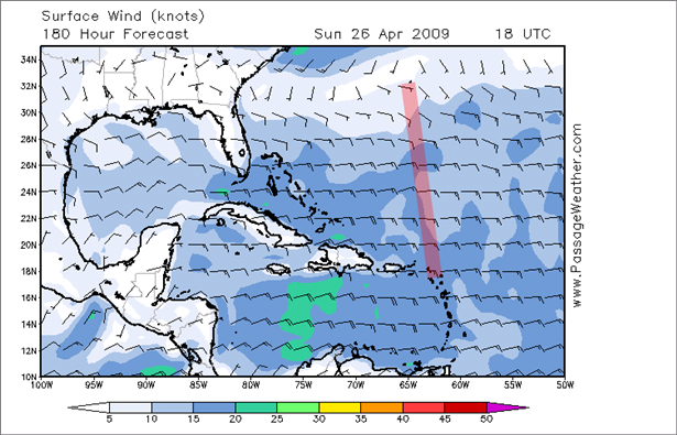
I downloaded the images into PowerPoint and added a red reference line to draw our eye to our intended path ...
... and then, considering that our position will be changing over time, I added yellow and clear alternating stripes to suggest our progress northward each day. The intersection of each stripe with the red line approximates our intended position ...
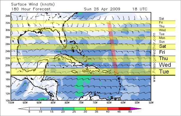
Finally, of course, not only will our position change, but the underlying weather forecast changes each day. Therefore, I animated each image in a slide show and can focus on the appropriate day's stripe - red line intersection based on the forecasted day labeled on the top of the image.
Animated Example
Well, you get the idea. Of course, we can only see (at best) a week out in the forecasts. Therefore, we are going with the hope that a front does not push through late in our voyage.
Why not wait a little longer? Well, that eventual threat of tropical cyclones may come early this year. According to one tropical storm forecaster...
So, we are ready ... I think. All of our boat chores are done to the best of our abilities, and everything appears sound and secure. Even with that, though, there is a palpable sense of tension in the air. We are both a little scared.
Despite the miles we have accumulated beneath our keels over the past four years, we are still relatively novice offshore sailors. Although the regions have often been remote, land has never been more than 24 hours away. This time it will be different. Whatever fate and mother nature throws at us, we will have to handle it on our own. I suppose that we can take comfort in the fact that we will act with our customary prudence at all times and then simply hope for the best.
Note that this will be our final blog post for some time to come. Predicting a landfall date is challenging enough, but then throw in the availability of internet access and things get really questionable. Bottom line, please do not worry. Instead, wish us luck in your hearts and hold the e-mails until you see a new CURRENT LOCATION posted with a much higher number for the latitude.
Until then,
Doug & Sheryl

17 04.505' N, 061 53.541' W
The time has come for us to wave goodbye to Antigua and to the Caribbean. Our weather analysis suggests that now is as good a time as any to head northward. We've gathered data from a variety of sources, including our good friend NOAA, but this time we have found that the most concise presentation of forecasted wind and wave conditions to suit our needs was to be found at PassageWeather.com. Their weather images look something like this:
I downloaded the images into PowerPoint and added a red reference line to draw our eye to our intended path ...
... and then, considering that our position will be changing over time, I added yellow and clear alternating stripes to suggest our progress northward each day. The intersection of each stripe with the red line approximates our intended position ...
Finally, of course, not only will our position change, but the underlying weather forecast changes each day. Therefore, I animated each image in a slide show and can focus on the appropriate day's stripe - red line intersection based on the forecasted day labeled on the top of the image.
Animated Example
Well, you get the idea. Of course, we can only see (at best) a week out in the forecasts. Therefore, we are going with the hope that a front does not push through late in our voyage.
Why not wait a little longer? Well, that eventual threat of tropical cyclones may come early this year. According to one tropical storm forecaster...
There are five hurricane seasons that have characteristics most similar to what was observed during February and March of 2009. These seasons are 1951, 1968, 1976, 1985 and 2001. One very interesting aspect regarding four out of the five years is that there was significant tropical storm development in May and June. In fact, 1951 had a major hurricane in mid to late May off of the US southeast coast. So, I am going to go out on a limb and forecast that there will be tropical storm or hurricane development close to the US coast between May 15 and June 5.So, even though it is a real long shot to forecast that kind of weather activity this far in advance, the mere notion of an increase in the possibility of encountering a tropical cyclone during our transit from Bermuda to the United States has lit a fire under us and hastened our departure slightly.
So, we are ready ... I think. All of our boat chores are done to the best of our abilities, and everything appears sound and secure. Even with that, though, there is a palpable sense of tension in the air. We are both a little scared.
Despite the miles we have accumulated beneath our keels over the past four years, we are still relatively novice offshore sailors. Although the regions have often been remote, land has never been more than 24 hours away. This time it will be different. Whatever fate and mother nature throws at us, we will have to handle it on our own. I suppose that we can take comfort in the fact that we will act with our customary prudence at all times and then simply hope for the best.
Note that this will be our final blog post for some time to come. Predicting a landfall date is challenging enough, but then throw in the availability of internet access and things get really questionable. Bottom line, please do not worry. Instead, wish us luck in your hearts and hold the e-mails until you see a new CURRENT LOCATION posted with a much higher number for the latitude.
Until then,
Doug & Sheryl
| Vessel Name: | Prudence |
| About: |
Gallery not available
- PHOTOS:
- Dec 16, 2008 - May 21, 2009
- Mar 17, 2008 - Dec 15, 2008
- Nov 01, 2007 - Mar 16, 2008
- Our SC35 Sailboat: PRUDENCE
- SELECTED BLOGS
- Jan'05: The Idea
- May'05: First Cruise - Belize
- Aug'05: Buying Ashiya
- Oct'05: School in St. Vincent
- Nov'05: Ocracoke on Ashiya
- Jul'06: Long Trip on Ashiya
- Oct'06: Prudence Comes Home
- Nov'07: First Night Offshore
- Nov'07: Offshore Take Two
- Nov'07: Gulf Stream Crossing
- Dec'07: Green Turtle Cay
- Dec'07: Lynyard Cay
- Dec'07: Warderick Wells Cay
- Jan'08: George Town
- Jan'08: Life without a Fridge
- Jan'08: Mayaguana Island
- Jan'08: Turks & Caicos
- Jan'08: Dominican Republic
- Jan'08: Down the Waterfalls
- Feb'08: Puerto Rico
- Feb'08: Starter Troubles
- Feb'08: Vieques
- Mar'08: Finally Sailing Again
- Mar'08: Trip So Far
- Mar'08: Hiking Culebra
- Mar'08: Kayak & Snorkel I
- Mar'08: Teak and Waterspouts
- Mar'08: Kayak & Snorkel II
- Mar'08: Bottom Cleaning
- Apr'08: Culebra Social Life
- Apr'08: Culebra Routine
- Apr'08: Culebra Beaches
- Apr'08: Culebrita
- Jun'08: Kayak & Snorkel III
- Jun'08: Kayak & Snorkel IV
- Jun'08: Manta Ray
- Jun'08: Sea Turtles
- Jul'08: Cost of Cruising
- Jul'08: Busy Week in Culebra
- Jul'08: Getting to Land
- Jul'08: Leatherback Boil
- Jul'08: Fish and Volcano Dust
- Aug'08: Teaching Algebra
- Sep'08: Culebra Card Club
- Oct'08: Kayak & Snorkel V
- Oct'08: Prep for Hurricane
- Oct'08: Hurricane Omar
- Oct'08: Fish and Sea Glass
- Oct'08: Waterspouts
- Dec'08: Hurricane Season Ends
- Dec'08: Culebra to St. Martin
- Jan'09: Antigua Part 1
- Feb'09: The Saints
- Feb'09: Visiting Dominica
- Mar'09: Antigua Part 2
- Apr'09: Antigua to Bermuda
- May'09: Bermuda to Norfolk
- FULL LIST of Blog Entries
SailBlogs Friends