
On to the Tuomotos -- Raroia atoll
Setting sail for the Tuomotus was a big deal for us as it would be our first significant passage since our arrival in the Marquesas over two moths prior. Unsure of our actual arrival time and weather that we’d encounter enroute, we decided that we would split the difference and set a course that would allow us to make landfall at either Raroia or Kauehi. As it turned out, our timing was good and we picked a great window for sailing; we had good winds, reaching almost the entire way. We were able to sail through the nights under clear skies and bright moonlight, under full sail with 14-18 knots of wind behind us.
On our third day, we sighted two low-lying atolls comprising the Disappointment Islands. We set our final course for Raroia and, later that day, encountered a trough in the weather and a line of squalls as far as we could see. We managed to slow down to let a few of these squalls pass in front of us, but when we saw the “gray weather wall”, we ran like hell! With motor and full sail together, we managed to slip between two squall lines and find our way to clearer weather. Our final night sleepless, as we were still running into squalls along our route, and we were thankful for the sunrise as we first spied our destination – Raroia!
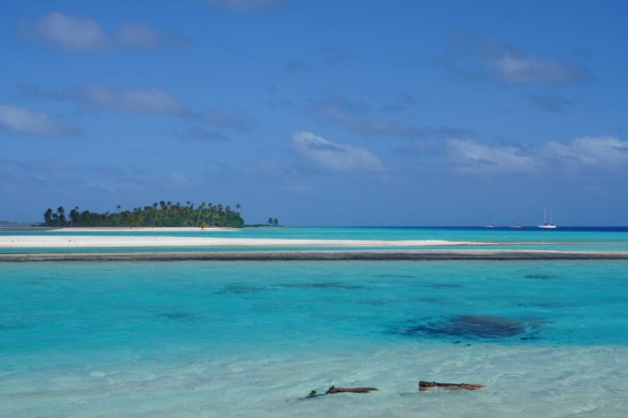
While still a part of French Polynesia, the Tuomotus and the Marquesas could not be more different. The Marqueses are relatively new, geologically, with high mountainous volcanic peaks and sheer cliffs dropping down to the ocean. The Tuomotu Archipelago is much older, consisting of atolls that are basically collapsed volcanoes. So far, our experience of “making landfall” meant seeing mountains in the distance. With atolls, we could see tiny specs of palm trees – through the binoculars – at no more than 10 miles out.
The Tuomotus are the stereotypical picture of an “uncharted desert island” from a movie scene – think Gilligan’s Island. Comprised of some 78 coral atolls, and spanning almost a 1000 miles across the ocean, each has a fringe reef with an inner lagoon that is relatively shallow – 150 feet or so, in the case of Raroia. These are not small atolls; Raroia is about 25 miles long and 8 miles across. Scattered along the fringe reef every ½ - 2 miles or so are various “motus” – basically piles of coral sand that have accumulated from the pounding surf, upon which some vegetation has taken hold (bushes, small deciduous trees, palm trees, etc.).
Strong currents often flow out of the lagoons, making entry difficult unless timed for a relatively slack tide. Once inside, we have to navigate around various “bommies” which are small coral atolls themselves, maybe 25-200 feet in diameter and 3-8 feet under the water. Until recently, sailors did not typically visit these islands, as they are very difficult and dangerous to navigate. In fact, the archipelago is often labeled on paper charts as the “Dangerous Islands.” But the advent of GPS, and then chart plotters and even Google Earth, has changed all of that by giving us much more information about what lies under the water between and within each atoll.
Entering the pass to Raroia was an entirely new sailing experience for us. Keep in mind, we had been sailing for three days, with little sleep – our anxiety about what lay ahead was keeping us alert. The first task was getting through the pass and into the actual lagoon itself, and there we had the new challenge of threading through the “bommies!” These atolls are immense “pools” of water and, with the tides, have incredibly strong inflows and outflows of water each day. Currents in the pass entries can be up to 8 knots. This means that, if your boat normally travels at 7 knots through the water, with an 8-knot current you are actually travelling BACKWARDS in the flow of water with 1 knot of speed. Timing your entry with the slack tide (neither ebbing nor flooding) is of course, ideal. The trick with this is … no one really knows when that time actually is. And on some atolls, if there are strong winds washing water over the reefs, there actually is NO slack tide, only a weaker tide. There is an excel-based tool developed by some of the cruisers that is called the Tuomotu Tide Guestimator that tries to provide guidance in all of this. But at the end of the day is it just that – a big guess. And so, ultimately, you need to rely upon what you can see and experience as you enter the pass.
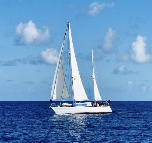
We expected to encounter a slack tide, but what we saw looked anything but “slack.” We were told to hug the north side (left) of the pass, as it was deeper. To our right, we saw waves crashing on the reef. In the middle we could see the current. I was nervous, but I had confidence in Athanor, and in Ev – our engine, so I gunned it. We had a strong outflow of current – approximately 2-3 knots which, when combined with a 20 knot headwind, reduced our speed over ground to approximately 3.5 knots. We powered through the pass, approximately 400 meters long or so, and then our speed started to ease up to 4 knots, then to 5 knots, and then we were back to our usual 6.5 knots. Whew!
But then came the next challenge – BOMMIES! We honestly had no idea what to expect. Susan I both had visions of tall skinny formations that would be lurking under the water, very hard to see, waiting to pierce the hull of a reckless sailboat. In reality, it turned out to be far less stressful than this. These “bommies” are coral formations rising up from the bottom of the atoll (approximately 50 meters in depth), approximately 25-50 meters across, that sit just below the surface. Usually, but not always, these formations have sand on the top that reflects the sunlight and makes them quite easy to see – as long as you have good sunlight and this sunlight is behind you rather than in your eyes! But not always -- there are some that are very hard to see, can sneak up on you, and that require us to be extra vigilant. We took it quite slow across the lagoon, motoring at 4-5 knots with me at the wheel and Susan spotting from the bow. We were quite lucky that another cruiser provided us with his track across the lagoon – helped a lot. No major mishaps, just one small motu hidden below the surface that caused Susan to yell “hard to port” … a new skill acquired.
Our first stop in the lagoon was the Kon Tiki anchorage. We anchored right behind the “Kon Tiki” motu, which is where the famous Kon Tiki expedition raft washed ashore following its 1947 voyage across the Pacific from Peru. The first night at anchor we watched a black and white documentary on the expedition. It is eerily spectacular to see footage of them on this exact motu some 70 years earlier. We explored the Kon Tiki monument, “reef walked”, etched our name on a mooring ball that had washed ashore, picked up trash that had washed ashore from sea, visited the pearl farm. To see – and hear - the ocean waves crashing onto the reef, just beyond the motu, is so strange. Here we are, anchored in crystal clear water, dead calm, and there’s just a reef between the powerful seas and us.
After a few days, we moved to a motu that lies at the far south end of the lagoon. The motu is nicknamed Jurassic Park and is home to THOUSANDS of birds, with birds coming and going all day and night. The name is amazingly appropriate. Upon anchoring in the bay, I donned snorkel gear to check our anchor and be sure it would be clear of any bommies should the winds change direction. Soon after entering, I heard Susan calling me, drawing my attention to a shark nearby in the water. And then another shark; then three sharks, then soon seven sharks! These were black tip reef sharks, approximately 4-5 feet in length, curious about the ship that had just invaded their space. I decided to dive the anchor a bit later. ;)
Here, we met and had great fun with Andrew & Claire aboard Eye Candy. They have been cruising for 11 years! They’ve seen it all, have great stories, and are wonderful people. Claire taught Susan how to make fresh bread; Andrew assisted me with our electrical charging system, and we compared notes on anchorages and weather patterns. We launched our kayaks and somehow felt much safer paddling in the lagoon watching the curious sea-life from above the water line! We had fun paddling up the estuaries, then cruising back with the current behind us. Susan set/achieved a goal to snorkel/swim for 10 full minutes – testing her courage to overcome her fear of the sharks. Indeed, they really could care less about us – it’s just hard to remember that as they swim about. We had heard about Coconut Crabs, so one afternoon Andrew and I (me with my PNW crabbing skills), made way to shore to catch dinner. We brought home 7, and enjoyed a “very light” meal (not the big Dungeness crabs we’re used to back home) with Andrew and Claire.
After two glorious weeks of near solitude, we realized that’s all we could stand and began plans to move on to our next atoll – Kauehi. We’ve heard wonderful things about this small atoll – namely the quaint village. We promise to share our experiences very soon!
Wishing you wonderful summer days,
Rob and Susan
On our third day, we sighted two low-lying atolls comprising the Disappointment Islands. We set our final course for Raroia and, later that day, encountered a trough in the weather and a line of squalls as far as we could see. We managed to slow down to let a few of these squalls pass in front of us, but when we saw the “gray weather wall”, we ran like hell! With motor and full sail together, we managed to slip between two squall lines and find our way to clearer weather. Our final night sleepless, as we were still running into squalls along our route, and we were thankful for the sunrise as we first spied our destination – Raroia!
While still a part of French Polynesia, the Tuomotus and the Marquesas could not be more different. The Marqueses are relatively new, geologically, with high mountainous volcanic peaks and sheer cliffs dropping down to the ocean. The Tuomotu Archipelago is much older, consisting of atolls that are basically collapsed volcanoes. So far, our experience of “making landfall” meant seeing mountains in the distance. With atolls, we could see tiny specs of palm trees – through the binoculars – at no more than 10 miles out.
The Tuomotus are the stereotypical picture of an “uncharted desert island” from a movie scene – think Gilligan’s Island. Comprised of some 78 coral atolls, and spanning almost a 1000 miles across the ocean, each has a fringe reef with an inner lagoon that is relatively shallow – 150 feet or so, in the case of Raroia. These are not small atolls; Raroia is about 25 miles long and 8 miles across. Scattered along the fringe reef every ½ - 2 miles or so are various “motus” – basically piles of coral sand that have accumulated from the pounding surf, upon which some vegetation has taken hold (bushes, small deciduous trees, palm trees, etc.).
Strong currents often flow out of the lagoons, making entry difficult unless timed for a relatively slack tide. Once inside, we have to navigate around various “bommies” which are small coral atolls themselves, maybe 25-200 feet in diameter and 3-8 feet under the water. Until recently, sailors did not typically visit these islands, as they are very difficult and dangerous to navigate. In fact, the archipelago is often labeled on paper charts as the “Dangerous Islands.” But the advent of GPS, and then chart plotters and even Google Earth, has changed all of that by giving us much more information about what lies under the water between and within each atoll.
Entering the pass to Raroia was an entirely new sailing experience for us. Keep in mind, we had been sailing for three days, with little sleep – our anxiety about what lay ahead was keeping us alert. The first task was getting through the pass and into the actual lagoon itself, and there we had the new challenge of threading through the “bommies!” These atolls are immense “pools” of water and, with the tides, have incredibly strong inflows and outflows of water each day. Currents in the pass entries can be up to 8 knots. This means that, if your boat normally travels at 7 knots through the water, with an 8-knot current you are actually travelling BACKWARDS in the flow of water with 1 knot of speed. Timing your entry with the slack tide (neither ebbing nor flooding) is of course, ideal. The trick with this is … no one really knows when that time actually is. And on some atolls, if there are strong winds washing water over the reefs, there actually is NO slack tide, only a weaker tide. There is an excel-based tool developed by some of the cruisers that is called the Tuomotu Tide Guestimator that tries to provide guidance in all of this. But at the end of the day is it just that – a big guess. And so, ultimately, you need to rely upon what you can see and experience as you enter the pass.
We expected to encounter a slack tide, but what we saw looked anything but “slack.” We were told to hug the north side (left) of the pass, as it was deeper. To our right, we saw waves crashing on the reef. In the middle we could see the current. I was nervous, but I had confidence in Athanor, and in Ev – our engine, so I gunned it. We had a strong outflow of current – approximately 2-3 knots which, when combined with a 20 knot headwind, reduced our speed over ground to approximately 3.5 knots. We powered through the pass, approximately 400 meters long or so, and then our speed started to ease up to 4 knots, then to 5 knots, and then we were back to our usual 6.5 knots. Whew!
But then came the next challenge – BOMMIES! We honestly had no idea what to expect. Susan I both had visions of tall skinny formations that would be lurking under the water, very hard to see, waiting to pierce the hull of a reckless sailboat. In reality, it turned out to be far less stressful than this. These “bommies” are coral formations rising up from the bottom of the atoll (approximately 50 meters in depth), approximately 25-50 meters across, that sit just below the surface. Usually, but not always, these formations have sand on the top that reflects the sunlight and makes them quite easy to see – as long as you have good sunlight and this sunlight is behind you rather than in your eyes! But not always -- there are some that are very hard to see, can sneak up on you, and that require us to be extra vigilant. We took it quite slow across the lagoon, motoring at 4-5 knots with me at the wheel and Susan spotting from the bow. We were quite lucky that another cruiser provided us with his track across the lagoon – helped a lot. No major mishaps, just one small motu hidden below the surface that caused Susan to yell “hard to port” … a new skill acquired.
Our first stop in the lagoon was the Kon Tiki anchorage. We anchored right behind the “Kon Tiki” motu, which is where the famous Kon Tiki expedition raft washed ashore following its 1947 voyage across the Pacific from Peru. The first night at anchor we watched a black and white documentary on the expedition. It is eerily spectacular to see footage of them on this exact motu some 70 years earlier. We explored the Kon Tiki monument, “reef walked”, etched our name on a mooring ball that had washed ashore, picked up trash that had washed ashore from sea, visited the pearl farm. To see – and hear - the ocean waves crashing onto the reef, just beyond the motu, is so strange. Here we are, anchored in crystal clear water, dead calm, and there’s just a reef between the powerful seas and us.
After a few days, we moved to a motu that lies at the far south end of the lagoon. The motu is nicknamed Jurassic Park and is home to THOUSANDS of birds, with birds coming and going all day and night. The name is amazingly appropriate. Upon anchoring in the bay, I donned snorkel gear to check our anchor and be sure it would be clear of any bommies should the winds change direction. Soon after entering, I heard Susan calling me, drawing my attention to a shark nearby in the water. And then another shark; then three sharks, then soon seven sharks! These were black tip reef sharks, approximately 4-5 feet in length, curious about the ship that had just invaded their space. I decided to dive the anchor a bit later. ;)
Here, we met and had great fun with Andrew & Claire aboard Eye Candy. They have been cruising for 11 years! They’ve seen it all, have great stories, and are wonderful people. Claire taught Susan how to make fresh bread; Andrew assisted me with our electrical charging system, and we compared notes on anchorages and weather patterns. We launched our kayaks and somehow felt much safer paddling in the lagoon watching the curious sea-life from above the water line! We had fun paddling up the estuaries, then cruising back with the current behind us. Susan set/achieved a goal to snorkel/swim for 10 full minutes – testing her courage to overcome her fear of the sharks. Indeed, they really could care less about us – it’s just hard to remember that as they swim about. We had heard about Coconut Crabs, so one afternoon Andrew and I (me with my PNW crabbing skills), made way to shore to catch dinner. We brought home 7, and enjoyed a “very light” meal (not the big Dungeness crabs we’re used to back home) with Andrew and Claire.
After two glorious weeks of near solitude, we realized that’s all we could stand and began plans to move on to our next atoll – Kauehi. We’ve heard wonderful things about this small atoll – namely the quaint village. We promise to share our experiences very soon!
Wishing you wonderful summer days,
Rob and Susan
Profile
Who: Robert Bordner & Susan Mitchell
Port: Seattle
Photo Albums


Comments