Tuamotus 25 oktober 2020
24 October 2020
• Pacific
by Wim
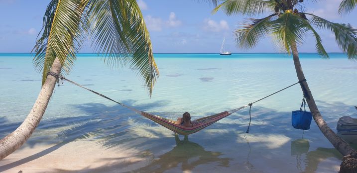
På bild: Elisabeth i hängmattan
Söndag den 25 oktober 2020, Twin Palms Yacht Club, Raroia, Tuamotus
En lugn dag. Elisabeth åkte in med hängmattan och bok och passade på att göra
tvätten iland. Jag skrapade rent sittbrunnen och testade ett annat spackel. En
segelbåt 'Askari', Australien, kom in på eftermiddagen.
På kvällen testade vi toppljuset igen och . . . inget. Om man tittade noga kunde
man se ett svagt rött ljus däruppe. Andreas lovade 'två års garanti' så vi får be
honom att ta sig upp i masten igen och kolla. Förmodligen är det själva
glödlampan eller behållaren (sockeln). Vi får testa med en vanlig glödlampa. När
vi testade lampan i sittbrunnen lyste den som den brukar. Det finns ström ,mer än
13 volt, upp till masttoppen. Ankarlampan lyser klart och tydligt.
Vi håller på att 'planera' lite inför framtiden. Det går trögt eftersom vi inte
har en aning om när länder öppnar sina gränser. Det blir i alla fall ett 'El
Niña' år i år så vi behöver inte oroa oss allt för mycket för orkaner här i
franska Polynesien.
Så här skriver Bob:
Bob McDavitt's ideas for sailing around the South Pacific.
Disclaimer: Weather is a mix of pattern and chaos; these ideas are from the
patterned world. Compiled Sun 25 Oct 2020
Southwest Pacific Tropical Cyclone Outlook the NIWA and Met Service assessment
of named tropical cyclone (TC) activity indicates 8 to 10 named TCs could occur
in the Southwest Pacific basin between November 2020 and April 2021. We are
having a La Nina. At present, sea surface temperature anomalies across the
eastern equatorial Pacific Ocean are cool (negative) while the central equatorial
Pacific Ocean has recently been trending toward cool conditions. For the coming
season, important differences are expected between the western and eastern halves
of the Southwest Pacific basin and also for early and late season activity.
Elevated TC presence is expected in and around the Coral Sea and north Tasman
Sea, especially during the late season between February and April. Reduced TC
activity is expected east of the International Dateline. The potential start to
cyclone activity may occur close to or after the New Year. New Caledonia is
expected to get the greatest TC activity. Near normal activity is expected for
Tokelau, Fiji, Vanuatu, the Solomon Islands and Papua New Guinea. Normal or
slightly reduced activity is expected for Tonga, Wallis & Futuna, and Samoa. For
the coming season, the risk for an ex-tropical cyclone affecting New Zealand is
considered above normal. If an ex-tropical cyclone comes close to the country,
there is a near-equal probability of it tracking to either the east or west of
the North Island, and landfall of a degrading ex-tropical cyclone is possible.