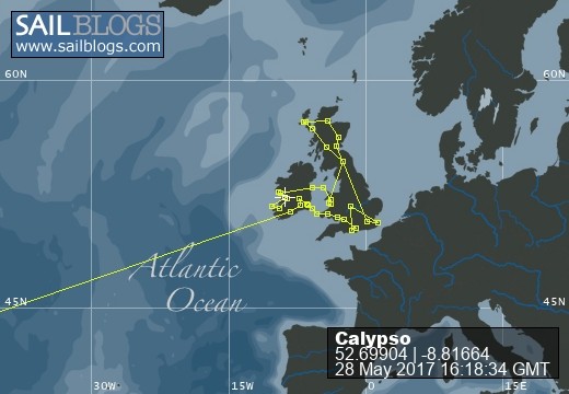
Log of Calypso

13 February 2023
08 February 2023
08 February 2023
04 February 2023
06 August 2022
01 August 2022 | Stonehaven, Scotland
28 July 2022
26 July 2022
25 July 2022
22 July 2022 | Edinburgh, Scotland
21 July 2022 | Glasgow
19 July 2022 | Edinburgh Scotland
19 July 2022
10 July 2022
10 July 2022
25 June 2020
03 June 2019
03 May 2019 | Charleston, SC
01 May 2019 | Brunswick, Ga
27 March 2019 | Palm Coast, Fl
Exuma Cays Land & Sea Park
23 January 2014 | Hawksbill Cay Mooring #5
After yesterday's fantastic sail to Hawksbill Cay, we picked up one of the park provided moorings, launched the dinghy, and headed ashore. With camera and water bottle in hand we went in search of a lush and tropical island, what we found was unexpected.
This park is 176 square miles, containing 15 major cays and several smaller ones too. Its formation goes back to 1953 when the superintendent of the Everglades National Park recommended the development of a park system in the Bahamas. In 1955 with the approval of England the park system was started.
The park headquarters is located at Warderick Wells about 5 miles away. It is a very popular location and cruisers flock to tie up to one of the 50+ moorings. We opted for Hawksbill due to its remote location and only 7 moorings. After staying at Norman's Cay with over 30 boats in the anchorage every night, how nice to see just one other boat tied up here with us.
Yesterday's explore was not at all what we expected. The park rules say to "Stay on the Trail". In other parks we have visited trails have signs, arrows, maps, or something to help guide you along. Not here, remember this is a remote park.
Just past the white sand beach we entered an area we now call "the moon". The majority of the island is coral & limestone. Those sections that are exposed to the wind and rain have had been eroded leaving a potmarked terrain resembling something that came from the lunar surface. This stuff was hard and sharp, don't fall here!
After stumbling along for several hundred yards we came across a pile of stones. Ah, a trail marker. We followed the markers until it came to a dead end at a mangrove estuary. OK, now what? Since it was low tide we could see that stones had been laid out so we could cross the mangroves without sinking into the muck. Using the stone markers we were able to walk across the island. Once we knew were we were going the return trip was much easier.
Today, while exploring a different section of the island we believe we were able to find the remains of several outbuildings and houses. They once were the homes of the Russell family who were the original family that settled the island in 1785.
We also took the dinghy and explored the small creek running through the mangroves. We topped it off by a climb up a 100' hill to take in a spectacular view from the mooring field to neighboring islands. We also go to see some of the local wildlife including a Bahamas Boa Constrictor. At least we think so, we didn't get too lose.
We found this not to be the lush green tropical island we anticipated finding. We found, however, that Hawksbill Cay has a very unique rugged beauty.
More Later, US
| Vessel Name: | Ex-Calypso |
| Hailing Port: | Morehead City, NC |
| Social: |
|
Ex-Calypso's Photos - Main
 |
Repair to Calypso's foredeck, mast step, rudder, & Seacock replacement
7 Photos
Created 3 November 2016
|
Port: Morehead City, NC