
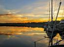
Carolina Mind
28 November 2016
28 October 2016
12 April 2015
30 March 2015
05 March 2015
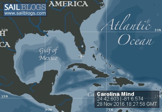
05 February 2015 | 24 57.932
25 January 2015 | Coconut Grove
24 December 2014 | Cocoa, FL
28 November 2014 | Jekyll Island, Ga
09 November 2014 | North Myrtle Beach, SC
So, where are we.
24 December 2014 | Cocoa, FL
Good morning,
At the end of each day of cruising, Beverly will generally ask me, "where are we". Sometimes the answer is not so obvious.
The single most important piece of information to a sailor is location. Without it, no other information about the ocean can be interpreted. Of course, the GPS provides our location to within a couple of meters, yes meters, giving us lat-long coordinates to several decimal places. Offshore, with no reference points other than the moving set of sun and stars, these coordinates are useful because you are moving towards another set of lat-long coordinates. Using this system, you can easily envision distance and direction to your destination, and those numbers a constantly on display on our boat. However, the numbers, taken alone, are unsatisfying to most people.
Navigating the coast and the ICW is rather different. It is impossible to head for a lat-long coordinate because the channel is rarely straight and usually meanders quite a bit. Often the general compass heading isn't even obvious without looking at the compass. In the middle of swamps or salt marshes there are often no reference points other than the occasional navigational aid. So, the answer to the question of "where are we" may be answered in a coastal context with the name of a river or creek and maybe a channel marker number. These are always available on the paper chart. However, without some familiarity with the local area, this frame of reference also is unsatisfying to many people, including Beverly.
Most of us, used to the context of cities, towns and highways generally expect a township based location. This is what Beverly would like to record in her journal. However, this information is not typically obvious on our chart plotter or on our paper charts. Because my focus in very myopically on coastal navigation, I generally have the chart plotter set to a radius of less than a quarter mile and I often answer her question with "I don't know"; even though I know our very precise location in two other reference systems.
In our recent travels, we have visited a number of these out of the way places, which is one of the major reasons for traveling on a very slow moving boat.
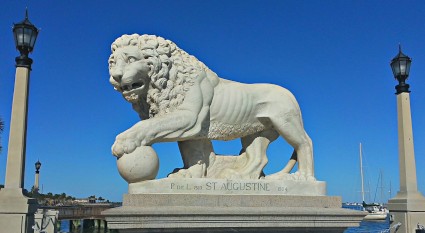
Of course, we pass by many cities too. A couple of weeks ago, we were in St.Augustine, FL, America's oldest city. This city is a popular tourist destination and can be crowded, but is charming nevertheless. We stayed at the City Marina and I was a little apprehensive on the approach even though we arrived at slack tide and with calm winds. The Grays had told a story of an approach to St. Augustine Municipal Marina in strong currents and high winds which I couldn't forget. Everything was fine for us. The city marina is located next to The Bridge of Lions, which is perhaps the prettiest bridge we have seen between the upper Chesapeake and here (pictures attached). In the city, there are many great restaurants, historic sites and shopping is just a bike ride away (biking being a topic for another update).
On leaving St. Augustine we traveled to Palm Coast and Daytona Beach anchorages before staying in Titusville a few days. Titusville is at the northern end of Brevard County with the chamber-of-commerce name of Space Coast. All the water views from Titusville feature NASA's Vehicle Assembly Building, located across the Indian River. One of the highly anticipated activities was to watch the NASA launch of the Orion spacecraft, which was scheduled for the morning of our arrival. However, we misunderstood the launch time and we failed to look in the right direction at the appropriate time and missed the launch!!!
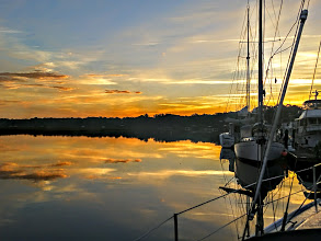
Titusville is showing the economic strain of the funding declines at NASA and many businesses are closed. While the marina and location are top notch, we needed to move south. Having talked to fellow cruisers about plans for the holidays, it seems most cruisers opt to stay in a marina for the month of December to take advantage of lower monthly rates causing the marinas fill to capacity. We were unaware of this and had not made reservations. The places where we wanted to be, further south, were full when we called, but we found a slip at Cocoa, FL. Cocoa is at the southern end of the Space Coast, about 25 miles south of Titusville.
If you have to be 'stranded' for a month, Cocoa is a great spot. The marina is located next to a pedestrian-oriented village with nice shops and restaurants, and a restored Victorian era theater. We went to a performance of the Nutcracker at the theater (fourth row seats) and found it to be outstanding.
Cocoa is just north of another small town named Rockledge. Rockledge has the charm of an old Florida coastal town without the tourist trappings of the new Florida. The road along the waterfront is designated as a Florida scenic route (palm trees and live oaks covered with Spanish moss) and a wonderful bike ride.
Soon, we will rent a car and drive to NC to visit family and friends. By mid-January we will again be pressing south.
Merry Christmas everyone.
At the end of each day of cruising, Beverly will generally ask me, "where are we". Sometimes the answer is not so obvious.
The single most important piece of information to a sailor is location. Without it, no other information about the ocean can be interpreted. Of course, the GPS provides our location to within a couple of meters, yes meters, giving us lat-long coordinates to several decimal places. Offshore, with no reference points other than the moving set of sun and stars, these coordinates are useful because you are moving towards another set of lat-long coordinates. Using this system, you can easily envision distance and direction to your destination, and those numbers a constantly on display on our boat. However, the numbers, taken alone, are unsatisfying to most people.
Navigating the coast and the ICW is rather different. It is impossible to head for a lat-long coordinate because the channel is rarely straight and usually meanders quite a bit. Often the general compass heading isn't even obvious without looking at the compass. In the middle of swamps or salt marshes there are often no reference points other than the occasional navigational aid. So, the answer to the question of "where are we" may be answered in a coastal context with the name of a river or creek and maybe a channel marker number. These are always available on the paper chart. However, without some familiarity with the local area, this frame of reference also is unsatisfying to many people, including Beverly.
Most of us, used to the context of cities, towns and highways generally expect a township based location. This is what Beverly would like to record in her journal. However, this information is not typically obvious on our chart plotter or on our paper charts. Because my focus in very myopically on coastal navigation, I generally have the chart plotter set to a radius of less than a quarter mile and I often answer her question with "I don't know"; even though I know our very precise location in two other reference systems.
In our recent travels, we have visited a number of these out of the way places, which is one of the major reasons for traveling on a very slow moving boat.
Of course, we pass by many cities too. A couple of weeks ago, we were in St.Augustine, FL, America's oldest city. This city is a popular tourist destination and can be crowded, but is charming nevertheless. We stayed at the City Marina and I was a little apprehensive on the approach even though we arrived at slack tide and with calm winds. The Grays had told a story of an approach to St. Augustine Municipal Marina in strong currents and high winds which I couldn't forget. Everything was fine for us. The city marina is located next to The Bridge of Lions, which is perhaps the prettiest bridge we have seen between the upper Chesapeake and here (pictures attached). In the city, there are many great restaurants, historic sites and shopping is just a bike ride away (biking being a topic for another update).
On leaving St. Augustine we traveled to Palm Coast and Daytona Beach anchorages before staying in Titusville a few days. Titusville is at the northern end of Brevard County with the chamber-of-commerce name of Space Coast. All the water views from Titusville feature NASA's Vehicle Assembly Building, located across the Indian River. One of the highly anticipated activities was to watch the NASA launch of the Orion spacecraft, which was scheduled for the morning of our arrival. However, we misunderstood the launch time and we failed to look in the right direction at the appropriate time and missed the launch!!!
Titusville is showing the economic strain of the funding declines at NASA and many businesses are closed. While the marina and location are top notch, we needed to move south. Having talked to fellow cruisers about plans for the holidays, it seems most cruisers opt to stay in a marina for the month of December to take advantage of lower monthly rates causing the marinas fill to capacity. We were unaware of this and had not made reservations. The places where we wanted to be, further south, were full when we called, but we found a slip at Cocoa, FL. Cocoa is at the southern end of the Space Coast, about 25 miles south of Titusville.
If you have to be 'stranded' for a month, Cocoa is a great spot. The marina is located next to a pedestrian-oriented village with nice shops and restaurants, and a restored Victorian era theater. We went to a performance of the Nutcracker at the theater (fourth row seats) and found it to be outstanding.
Cocoa is just north of another small town named Rockledge. Rockledge has the charm of an old Florida coastal town without the tourist trappings of the new Florida. The road along the waterfront is designated as a Florida scenic route (palm trees and live oaks covered with Spanish moss) and a wonderful bike ride.
Soon, we will rent a car and drive to NC to visit family and friends. By mid-January we will again be pressing south.
Merry Christmas everyone.
Comments
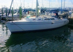
| Vessel Name: | Carolina Mind |
| Vessel Make/Model: | Catalina 350 |
| Hailing Port: | Beaufort, NC |
| Crew: | David and Beverly Johnson |
Carolina Mind's Photos - Main
, Marathon.jpg) |
Pictures from our time based in Marathon, FL, at the Harbor Cay Club Marina.
64 Photos
Created 8 March 2017
|
 |
Trip from NC to Florida Keys and more
63 Photos
Created 28 October 2016
|
 |
Just a few pictures from our visits to Key West and Marathon
8 Photos
Created 13 April 2015
|
Who: David and Beverly Johnson
Port: Beaufort, NC
Gallery
, Marathon.jpg)

Updates
SailBlogs Friends
