
s/v Ceili
"You live with a ship a few years and cuss her enough and all of a sudden one day you wake up and discover you're in love." ----Ernest K. Gann, CMA 1930 and Author of "Twilight For The Gods" and Captain of the brigantine ALBATROS
13 May 2012
09 April 2012
02 April 2012
26 March 2012
18 March 2012 | Vero Beach
12 March 2012 | Green Turtle Cay, Abacos, Bahamas
20 February 2012 | Sea of Abaco
20 February 2012
15 February 2012
03 February 2012 | Marsh Harbour
01 January 2012 | Marsh Harbour, Abacos
24 December 2011
23 December 2011
22 December 2011
22 December 2011
18 December 2011
17 December 2011
17 December 2011
13 December 2011
08 December 2011 | West End, Bahamas
Gulf Stream Crossing
08 December 2011 | West End, Bahamas
Bill
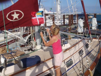
Linda Hoists Bahamian Courtesy Flag At Old Bahama Bay
We departed Vero Beach on Monday, hopeful of an improving weather forecast for favorable conditions to cross the Gulf Sream to the Bahamas. Our 9 days there provided ample time to provision and ready the boat for the crossing. On Monday night, we anchored in Hobe Sound about 50 miles south of Vero, and on Tuesday made the short hop to Lake Worth and anchored there close the the Lake Worth Inlet.
The Bahama crossing is well known among cruisers and must be approached with caution because of the strong Gulf Stream, which flows at about 3 knots north between Florida and the Bahamas. When opposed by a wind with a northern component, the Gulf Stream riles up with sharp, steep, and dangerous waves. Thus, boaters must take this into account and wait each year for the right "weather window" before crossing to or from the Bahamas.
The prevailing winds had been consistently from the north, making a crossing chancy, but forecasts showed a "window" developing with light east to south winds on Tuesday and Wednesday, before a strong northerly wind would return on Wednesday night. The seas were forecast to be light chop with a 6 foot northerly swell.
We weighed anchor at 5 AM yesterday morning, and in darkness motored the short distance to the Lake Worth Inlet. There was a full moon and enough reflected light to avoid the myriad of boats as we left the anchorage. As we left the inlet, we faced an uncomfortable chop which began in the surf zone and persisted for several hours.
The predicted location of the west wall of the Gulf Stream was 8 miles offshore, but we began to experience noticable northerly set just several miles after leaving the inlet. The rhumb line course to West End, Bahamas is 100 degrees, but we headed more southerly at about 115 degrees to correct for the drift. Uncorrected, a 100 degree course would put us 15 miles north of our destination. It turns out that it is best to head southerly early, before the stream reaches maximum velocity, so that time spent in the 30 mile wide stream can be minimized. An ideal course would describe an "S curve" where the "S " dips to the south early, crosses the stream near midway, and returns to the rhumb line from the north, hopefully terminating at the chosen destination. As it would turn out, our course would describe a northerly arc instead of a curve, because of our delay in turning south.
As we entered the Gulf Stream, the sea turned a brilliant cobalt blue. A pod of dolphins joined us, surfing in our stern wake. The water was so clear that we could see them swimming underwater. They played with us for minutes before disappearing as quickly as they came. Later, we began to see groups of flying fish, popping out of the water ahead of the boat. They seemed to fly forever, before diving back into the water.
Conditions improved as we sailed east, towards a brilliant sun. The seas flattened and winds turned southerly. We unfurled jib and staysail, and were soon making over 7 kts towards West End. At 2 pm we sighted land, and entered the narrow channel to Old Colony Bay Marina shortly thereafter. Another new experience for us was to watch the depths decrease from over 1000 feet to 15 feet in a matter of several minutes. We could now see the bottom as we motored in....always a bad sign in New England, but a good one in the Bahamas.
Immediately after docking, we raised the "Q" flag and were handed a sheaf of papers to fill out before checking through customs and immigration. Only the "captain" may leave the boat until cleared through. The process went smoothly, even though some of the questions seemed difficult to answer, so we left them blank....the officer was quite helpful in completing our forms. We struck up a friendly banter, discussed the Red Sox v. Yankees (they're Yankee fans)....half in jest he asked me "Does your wife know how to shoot?" I truthfully answered "Yes she does." He then asked, "Well, then, do you have any firearms aboard?" To which I replied, "Of course not, she's too good a shot."
Fortunately, that got a laugh instead of a scowl, or worse, a boat inspection. (Firearms are allowed in the Bahamas, but must be documented on entry to the country.)
Comments
| Vessel Name: | CEILI |
| Vessel Make/Model: | Island Packet 40 (hull #50) |
| Hailing Port: | Providence, RI |
| Crew: | Bill and Linda Daley |
| About: | Currently sailing the coast of New England in anticipation of heading South someday. Ceili is currently moored in East Greenwich, R.I. We have been sailing for awhile now, and are both USCG licensed captains (hence, no crew!) |
| Extra: | "Ceili" (kay'- lee) is gaelic for "joyful celebration." It reflects our Irish roots. |
Gallery not available
s/v CEILI
Who: Bill and Linda Daley
Port: Providence, RI
Table of Contents
Interesting Links
- Bahamian Chicken Souse
- Aldrich Mansion
- Amokura
- AtLantic Highlands Harbor
- Baltimore Promenade
- Block Island
- C and D Canal
- Capt. Billy Joel Designer Man
- CEILI on YouTube
- Coecles Harbor Marina
- Concordia Yawls/Padanaram
- Coronet/IYRS
- Current NY weather RADAR
- Current Wind Observations
- Cuttyhunk
- Cuttyhunk Fishing Club Slide Show
- Dark 'n Stormy Redux
- Dunkirk's Heroes Return
- Dutch Harbor
- Father's Day Rescue
- Fishers Island
- GAM Single Sideband Antenna
- Glebe Creek Screenworks
- Goslings Rum
- Greatland Laser Flare
- Island Packet 40 Specs
- Island Packet Photos
- Island Packet Yachts
- Katama Breach
- Lopolight
- Maine harbors
- Marine Traffic/AIS
- Masquerade Sailblog
- McMurdo FastFind PLB
- Montauk
- National Hurricane Center
- New Bedford YC/Padanaram
- Newport
- Ocean Marine Systems
- OUR BOAT PROJECTS
- Pangaea Expedition
- Queens's Wave
- Rapid Diver
- S/V ONWARD
- Safety at Sea Seminar
- Scott Boomlock
- Seven Drowned in Tarpaulin Cove
- Shelter Island
- Sleighride
- Star Island Marina-Montauk
- Stonington,CT
- Sydney Boats Ablaze
- THE BEST Ginger Beer
- The Greatest Great White
- WebCam: Edgartown Marine
- WebCam:Block Island
- WebCam:Cape Cod Canal
- WebCam:Hyannis Harbor
- WebCam:Newport
- YANMAR Help!!!