Downeast in Southeast Alaska
| Vessel Name: | Cimarron |
| Vessel Make/Model: | 1976 32' Downeast |
| Hailing Port: | Auke Bay, AK |
| Crew: | Diane and Harry |
| About: | We've been cruising SE Alaska waters on the Cimarron since 2001. Our home port is near Juneau. |
| Social: |
 |
08 August 2019 | Taku Harbor
07 August 2019 | Tracy Arm cove
06 August 2019 | West Brother Island
05 August 2019 | Farragut Bay
04 August 2019 | Petersburg
03 August 2019 | Petersburg
02 August 2019 | Deception Pt.
01 August 2019 | Thom's Place
31 July 2019 | Meyers Chuck
30 July 2019 | Ketchikan
29 July 2019 | Ketchikan
28 July 2019 | Foggy Bay
27 July 2019 | Brundige Inlet
26 July 2019 | Prince Rupert
25 July 2019 | Kelp Bay
24 July 2019 | Exposed Inlet
23 July 2019 | Exposed Inlet
22 July 2019 | Coghlan Anchorage
21 July 2019 | Bishop Bay
20 July 2019 | Khutze Inlet
Recent Blog Posts
Unease in Desolation
04 July 2019 | Gloucester Pt.
Diane Meador

Leave Cochrane Islands Anchorage 8:50a
At Walsh Cove 1:30p
Anchor down in cove by Gloucester Pt., W. Redonda Island 2:50p
Stern anchor deployed 3:55p
50 16.937:-124 49.512
Happy Fourth of July in Desolation!
Desolation Sound was certainly pretty, the landscape dramatic, with mountains diving down through the water. But it's not a waterway through wilderness, and so it doesn't really qualify as spectacular to me. There were a few houses - more on the mainland side; some logged areas and logging roads - more extensive on the mainland. Cergainly less than what we've seen further south.There were lots of boats tooling about, and even more in the paucity of anchorages. All of the ones in the Desolation Sound Marine Park were jammed. It's a holiday for the Americans, and we're still within the one-week-out zone for vacationers from Friday Harbor on a 2-week vacation on their motor vessels. Then there are the Canadians who planned their 2- week vacation around Canada Day.
There had apparently been a forest fire recently - the forest on the NE side of E. Redonda Island was dead. I'm glad we took the scenic route, though. I would have wondered what it was like had we taken the short cut.
A number of those vacationers landed in our Plan anchorage at Walsh Cove, digging in even before our early arrival at 1:30p. A bunch of them were stern tied to shore, shoe-horned in like an ill-fitting pair of dress shoes. Blast. No room at the inn. So we putted down to the next cove, to find fish pens (which we expecting) and a cargo ship (which we weren't) filling the only other nook. We could have kept going down Waddington Channel, but that was going farther and farther away from our destination tomorrow: Hole in the Wall, which requires that we be at some rapids by the slack at 1:07p tomorrow. So, we spun around, hung a left after the choke on Waddington's north side, on the hunt for a wide spot in the road to drop our hook. That ended up being an unnamed cove by Gloucester Pt. on West Redonda Island. It's very steep to, and I can just about spit and reach shore, with 5 to 6 fathoms under us. If there were any wind, I'd definitely be able to reach shore. I circled the cove twice getting the lay of the bottom topography. Our max anchoring depth is about 11 fathoms - to get at least the 3:1 scope in our confidence zone for not dragging anchor. It was a narrow ledge, jumping from about 14 fathoms to 5, some 30' or so closer to shore. If we dragged at all toward shore, we'd quickly go aground. If we dragged at all the other way, we'd quickly be adrift. There shouldn't be any wind tonight, but for some added insurance, we deployed the stern anchor to keep us from swinging. After 20 years with the Cimarron, this was the first time we've ever felt the need for a stern anchor. I guess maintaining what we've always considered our backup should we lose our primary anchor has paid off.
A non-optimal anchorage, perhaps, but it gets several million Brownie points for being secluded.
Comments
Cimarron's Photos - Main
 |
About & Links
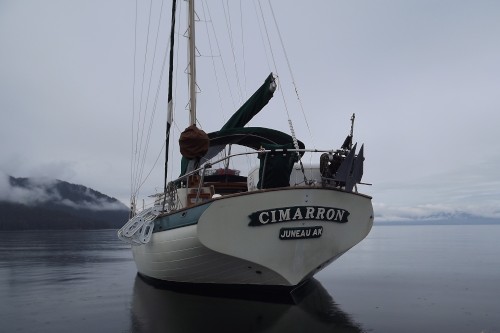
Photo Albums
 |
21 June 2016
61 Photos
|