Downeast in Southeast Alaska
| Vessel Name: | Cimarron |
| Vessel Make/Model: | 1976 32' Downeast |
| Hailing Port: | Auke Bay, AK |
| Crew: | Diane and Harry |
| About: | We've been cruising SE Alaska waters on the Cimarron since 2001. Our home port is near Juneau. |
| Social: |
 |
08 August 2019 | Taku Harbor
07 August 2019 | Tracy Arm cove
06 August 2019 | West Brother Island
05 August 2019 | Farragut Bay
04 August 2019 | Petersburg
03 August 2019 | Petersburg
02 August 2019 | Deception Pt.
01 August 2019 | Thom's Place
31 July 2019 | Meyers Chuck
30 July 2019 | Ketchikan
29 July 2019 | Ketchikan
28 July 2019 | Foggy Bay
27 July 2019 | Brundige Inlet
26 July 2019 | Prince Rupert
25 July 2019 | Kelp Bay
24 July 2019 | Exposed Inlet
23 July 2019 | Exposed Inlet
22 July 2019 | Coghlan Anchorage
21 July 2019 | Bishop Bay
20 July 2019 | Khutze Inlet
Recent Blog Posts
A tempest is building
23 July 2019 | Exposed Inlet
Diane Meador
Leave Coghlan 11:55a
Arrive Exposed Inlet, Klewnuggit 3:55p
53 39.97:-129 42.92
Meh - I really didn't want to go into Hartley at low tide in tight quarters, futz around, get fuel, and then cruise until 7 pm. Harry agreed, so we blew it off.
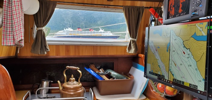
We expected a slow couple of hours starting out today, followed by a 1 - 3 knot boost (increasing over the day) going up Grenville Channel. The low tide at Hartley Bay (around the corner from Coghlan) was just before noon, but the turn to flood in Grenville should have been 2:16p, about 10 miles up the 45-mile long channel. It's one of those channels where the flood enters from both ends and meets in the middle. We were doing a 32 mile run, and figured it'd take us 5 or 6 hours. Somehow, we were riding the current the whole way, and did it in 4. Hell, we were doing almost 9 knots at times. A tail wind and motor sailing with the genny didn't hurt. I figure we were in the back eddy close to shore. We skoogied over to the side of the quarter-mile wide channel to let several fishing vessels and a Disney cruise ship go by.
We put in close to the place where the current swaps direction, in Klewnuggit. The preferred anchorage is up one of its N-S arms, but we put in at the ominously named Exposed Inlet instead. It is, indeed, very exposed to the NW (I think we can see all the way to Russia from here), but protected from the S winds we are expecting. We may need to hole up here a couple days, actually - it's blowing a gale out in Dixon Entrance (where we're heading) right now, and it's forecasted to reach storm strength winds greater than 35 knots out there.
Sounds like a tempest building out there. But pretty calm and idyllic in here, at least at the moment. We'll probably need to batten the hatches, de-thwack, and lash things down soon. We are getting a bit low on fuel for high sea conditions, as well as on reefer food and probably water, but we still have a decent inventory of canned and dehydrated foods, and I'll deploy the water catchment canvas I made when it starts raining tomorrow. It's really kinda absurd how much I love this.
We drank the last beer at anchor-down. We saved the apricot for last.
Arrive Exposed Inlet, Klewnuggit 3:55p
53 39.97:-129 42.92
Meh - I really didn't want to go into Hartley at low tide in tight quarters, futz around, get fuel, and then cruise until 7 pm. Harry agreed, so we blew it off.
We expected a slow couple of hours starting out today, followed by a 1 - 3 knot boost (increasing over the day) going up Grenville Channel. The low tide at Hartley Bay (around the corner from Coghlan) was just before noon, but the turn to flood in Grenville should have been 2:16p, about 10 miles up the 45-mile long channel. It's one of those channels where the flood enters from both ends and meets in the middle. We were doing a 32 mile run, and figured it'd take us 5 or 6 hours. Somehow, we were riding the current the whole way, and did it in 4. Hell, we were doing almost 9 knots at times. A tail wind and motor sailing with the genny didn't hurt. I figure we were in the back eddy close to shore. We skoogied over to the side of the quarter-mile wide channel to let several fishing vessels and a Disney cruise ship go by.
We put in close to the place where the current swaps direction, in Klewnuggit. The preferred anchorage is up one of its N-S arms, but we put in at the ominously named Exposed Inlet instead. It is, indeed, very exposed to the NW (I think we can see all the way to Russia from here), but protected from the S winds we are expecting. We may need to hole up here a couple days, actually - it's blowing a gale out in Dixon Entrance (where we're heading) right now, and it's forecasted to reach storm strength winds greater than 35 knots out there.
Sounds like a tempest building out there. But pretty calm and idyllic in here, at least at the moment. We'll probably need to batten the hatches, de-thwack, and lash things down soon. We are getting a bit low on fuel for high sea conditions, as well as on reefer food and probably water, but we still have a decent inventory of canned and dehydrated foods, and I'll deploy the water catchment canvas I made when it starts raining tomorrow. It's really kinda absurd how much I love this.
We drank the last beer at anchor-down. We saved the apricot for last.
Comments
Cimarron's Photos - Main
 |
About & Links
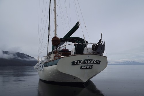
Photo Albums
 |
21 June 2016
61 Photos
|