Change of Latitude in the Pacific Northwest
Change of Latitude in the Pacific Northwest
Who: Don/Debbie/Katie Baxter/Sarah Leu
Port: Bellingham, WA
Table of Contents
SailBlogs Friends

20 May 2016
19 May 2016
18 May 2016
18 May 2016
17 May 2016
17 May 2016
17 May 2016
17 May 2016
17 May 2016
17 May 2016
17 May 2016
17 May 2016
17 May 2016
17 May 2016 | Butchart Gardens, BC
16 May 2016
16 May 2016 | Port Sidney
15 May 2016 | Stewart Island
08 May 2016 | Bellingham, WA
A change in plans
19 July 2010 | Blind Channel, BC
Don/Stuffed from a wonderful meal with Katie
Blind Channel Marina
I am sitting on our boat in the evening, wondering how my brother Dave writes a new blog post, before he goes to bed each night. He never fails and I really enjoy his description of their adventures as he and his wife, Mary, sail around the world in Leu Cat, a catamaran. He was the inspiration for this attempt at describing our adventures this summer. Dave and Mary's blog is linked at the side of this one. His posts are amazingly descriptive and entertaining. How he does this each day, with photos no less, is stunning. If you have not read his blog, you should. It is a daily read for hundreds, if not more, cruisers and would be cruisers, around he world. Dave and Mary are exceptional cruisers.
Today, Katie and I slept in. We deserved it after such a long day, yesterday. Determined to get up to Port McNeil in time to do a little fishing and crabbing, before Debbie, Sarah, and John arrive, we are trying to make time. Thus, a few long days are scheduled.
We began what was to be another long day with a healthy breakfast, one containing all of the important food groups: nuts, whole grains, and fruit. Cookies!!! We had provisioned a bunch of exceptional oatmeal, raisin, and walnut cookies in Bellingham. Today we made the most of that decision.
We did not have to depart until 11 am today. We needed to wait for the tide to be right at Seymour Narrows, a place with tidal currents up to 15 knots. Before a major feat of engineering blew Ripple Rock up, this was the most dangerous place to navigate in North America. (To read about Seymour Narrows and the blowing up of Ripple Rock see: http://www.vancouverislandabound.com/tamingof.htm) Slack water was at 12:50 pm and we were just 8 miles away. No need to leave early.
Before we lifted anchor, we checked the weather report for Johnston Straight. We were headed for Port Neville today, a somewhat remote anchorage, out of the winds of Johnston Straight. Bad news, though. A front was coming and gale force winds, over 30 knots, were forecast for Johnston Straight in the late afternoon. Since we had to depart late, we would be in the midst of that gale if we wanted to anchor at Port Neville. We poured over our books and sources for an alternative. Nothing seemed to be described except for the admonition, "You do not want to be in Current Passage (part of our route to Port Neville) with outgoing tide (there would be) and winds of 30 knots. The seas will reach 6-10 feet in an instant. You will feel like you have been in a washing machine."
Not having planned for that particular feeling on this trip, we found what looked to be a great place - Blind Channel Marina - just a few miles off of our route. The weather is scheduled to continue to be bad for the next few days, with lighter winds in the morning (15-20 knots). Our plan is to stay at Blind Channel tonight. Then, tomorrow, we will leave very early and try to make Port McNeil, arriving on schedule. If the winds are bad, we will pull into Port Neville and attempt to make Port McNeil the next day.
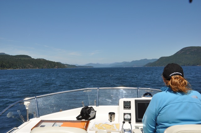
We headed for Seymour Narrows, the site of Vancouver's discovery, fighting currents of 4-5 knots. As we approached, the currents lessened, as predicted, and we went right through, saying thank you to the engineers who blew up Ripple Rock. They drilled a tunnel under the narrows and right up into the heart of Ripple Rock. Then, they placed nearly 1,500 tons of explosives in the heart of that rock and blew it up. See the photos at: http://www.vancouverislandabound.com/tamingof.htm
We went quickly through and made it down Discovery Passage. A photo of Katie, taking down Discovery Passage, appears above. We hung a right (I mean Starboard) and found Blind Channel Marina. It seems a little rolly polly here at the dock, but it will do for tonight. Katie and I had a wonderful meal of Lamb, Greek salad, and home-made pita bread and humus up a their restaurant. (The marina is run by several families, sons and daughters, of the original owners). We split a 4-berry crumble and lemon-thyme ice cream. Ummmmmm.
We are now checking the weather in hopes of making it to Port McNeil before the winds pick up again tomorrow.
By the way, a few people may think that Katie and I are underpowered when it comes to the technology tools we brought brought onboard. They may be right. The photo below shows that we only have three laptops, one iPad, and two iPhones (one took the picture.) One never knows when you might need to check weather! ;-)
I am sitting on our boat in the evening, wondering how my brother Dave writes a new blog post, before he goes to bed each night. He never fails and I really enjoy his description of their adventures as he and his wife, Mary, sail around the world in Leu Cat, a catamaran. He was the inspiration for this attempt at describing our adventures this summer. Dave and Mary's blog is linked at the side of this one. His posts are amazingly descriptive and entertaining. How he does this each day, with photos no less, is stunning. If you have not read his blog, you should. It is a daily read for hundreds, if not more, cruisers and would be cruisers, around he world. Dave and Mary are exceptional cruisers.
Today, Katie and I slept in. We deserved it after such a long day, yesterday. Determined to get up to Port McNeil in time to do a little fishing and crabbing, before Debbie, Sarah, and John arrive, we are trying to make time. Thus, a few long days are scheduled.
We began what was to be another long day with a healthy breakfast, one containing all of the important food groups: nuts, whole grains, and fruit. Cookies!!! We had provisioned a bunch of exceptional oatmeal, raisin, and walnut cookies in Bellingham. Today we made the most of that decision.
We did not have to depart until 11 am today. We needed to wait for the tide to be right at Seymour Narrows, a place with tidal currents up to 15 knots. Before a major feat of engineering blew Ripple Rock up, this was the most dangerous place to navigate in North America. (To read about Seymour Narrows and the blowing up of Ripple Rock see: http://www.vancouverislandabound.com/tamingof.htm) Slack water was at 12:50 pm and we were just 8 miles away. No need to leave early.
Before we lifted anchor, we checked the weather report for Johnston Straight. We were headed for Port Neville today, a somewhat remote anchorage, out of the winds of Johnston Straight. Bad news, though. A front was coming and gale force winds, over 30 knots, were forecast for Johnston Straight in the late afternoon. Since we had to depart late, we would be in the midst of that gale if we wanted to anchor at Port Neville. We poured over our books and sources for an alternative. Nothing seemed to be described except for the admonition, "You do not want to be in Current Passage (part of our route to Port Neville) with outgoing tide (there would be) and winds of 30 knots. The seas will reach 6-10 feet in an instant. You will feel like you have been in a washing machine."
Not having planned for that particular feeling on this trip, we found what looked to be a great place - Blind Channel Marina - just a few miles off of our route. The weather is scheduled to continue to be bad for the next few days, with lighter winds in the morning (15-20 knots). Our plan is to stay at Blind Channel tonight. Then, tomorrow, we will leave very early and try to make Port McNeil, arriving on schedule. If the winds are bad, we will pull into Port Neville and attempt to make Port McNeil the next day.
We headed for Seymour Narrows, the site of Vancouver's discovery, fighting currents of 4-5 knots. As we approached, the currents lessened, as predicted, and we went right through, saying thank you to the engineers who blew up Ripple Rock. They drilled a tunnel under the narrows and right up into the heart of Ripple Rock. Then, they placed nearly 1,500 tons of explosives in the heart of that rock and blew it up. See the photos at: http://www.vancouverislandabound.com/tamingof.htm
We went quickly through and made it down Discovery Passage. A photo of Katie, taking down Discovery Passage, appears above. We hung a right (I mean Starboard) and found Blind Channel Marina. It seems a little rolly polly here at the dock, but it will do for tonight. Katie and I had a wonderful meal of Lamb, Greek salad, and home-made pita bread and humus up a their restaurant. (The marina is run by several families, sons and daughters, of the original owners). We split a 4-berry crumble and lemon-thyme ice cream. Ummmmmm.
We are now checking the weather in hopes of making it to Port McNeil before the winds pick up again tomorrow.
By the way, a few people may think that Katie and I are underpowered when it comes to the technology tools we brought brought onboard. They may be right. The photo below shows that we only have three laptops, one iPad, and two iPhones (one took the picture.) One never knows when you might need to check weather! ;-)
Comments
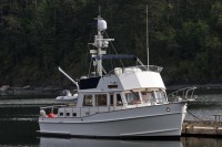
| Vessel Name: | Change of Latitude |
| Vessel Make/Model: | Grand Banks CL 42 |
| Hailing Port: | Bellingham, WA |
| Crew: | Don/Debbie/Katie Baxter/Sarah Leu |
| About: | We live on the East Coast but enjoy wilderness cruising in the Pacific Northwest. |
| Extra: | We enjoy crabbing, shrimping, fishing, and clamming. Some of us are crazy enough to swim in Northwest waters during the summer. |
Gallery not available
Change of Latitude in the Pacific Northwest
Who: Don/Debbie/Katie Baxter/Sarah Leu
Port: Bellingham, WA
Table of Contents
SailBlogs Friends