Delivery Captain
13 May 2011 | Morro Bay
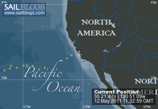
12 May 2011
10 May 2011 | 35 15'N:122 45'W, California Waters
09 May 2011 | 34 38'N:123 52'W, Pacific High
07 May 2011 | 32 36'N:129 27'W, Pacific High
06 May 2011 | 32 36'N:129 27'W, Pacific High
05 May 2011 | 32 13'N:130 52'W, Pacific High
04 May 2011 | 32 58'N:132 31'W, Pacific High
03 May 2011 | 33 08'N:133 56'W, Pacific High
02 May 2011 | 33 05'N:134 46'W, Pacific High
01 May 2011 | 32 35'N:136 26'W, Pacific High
01 May 2011 | 32 59'N:137 59'W, Pacific High
29 April 2011 | 32 59'N:137 59'W, Pacific High
28 April 2011 | 32 26'N:138 12'W, Pacific Gyre
27 April 2011 | 32 02'N:139 35'W, Pacific Gyre
26 April 2011 | 31 33'N:141 15'W, Pacific Gyre
25 April 2011 | 30 52'N:143 33'W, Pacific Gyre
24 April 2011 | 30 28'N:144 50'W, waterworld
23 April 2011 | 29 53'N:146 28'W, waterworld
22 April 2011 | 29 16'N:148 16'W, waterworld
Shot One
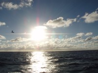
05 May 2011 | 32 13'N:130 52'W, Pacific High
Lynn
Well we are on a beam reach and the swells are hitting our port side, about 8 to 10', 15 kts out of the northeast. This will be the norm until Saturday when the winds shift to the northwest. At that time we can resume course to Morro Bay. On this tack we are making 5 to 7 kts whereas if we were to motor directly to Morro Bay, because of the swell, only about 2.5 kts. This will also allow us to get to calmer seas and favorable winds. We are only 20 miles or so south of our intended course and making better time to the coast. Like I said above, we can adjust later and this is much better direction for both the boat and crew. The last 500 miles is the hardest part of the trip so I want to make sure all is well and nothing breaks. Better to take an extra day that to look at the ass end of a Coast Guard cutter!!!!! Still looking to arrive early in the week. Weather permitting. Lynn
Comments
| Vessel Name: | Delivery Captain |
| Vessel Make/Model: | Any |
| Hailing Port: | Avalon,Ca. |
| Crew: | Lynn A. Stokes,Captain |
| About: | |
| Extra: | Willing to deliver just about anything that is seaworthy, anytime, anywhere. Also have worked as a consultant to help folks either to go cruising or to improve their experience on the ocean. |
Delivery Captain's Photos - Main
 |
 |
Pics from the 2nd attempt to get this beauty home! This is what happens when you buy a Line Is. Surf Charter boat! Surfs Up Dude!
27 Photos
Created 14 October 2010
|
 |
16 days up and 7 back. Selected sailing photos
39 Photos
Created 23 August 2010
|
 |
Delivery Captain
Who: Lynn A. Stokes,Captain
Port: Avalon,Ca.