SV Delos
| Vessel Name: | delos |
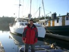
08 July 2008 | Shileshole Marina
Day 20- Home sweet home!
The rest of the night through the straits was uneventful. There was a lot of shipping traffic but it clearly showed up on the AIS and radar. We pulled into Port Townsend just before 6:00AM to a beautiful, sunny, clear morning. There wasn't a breath of wind and the water was like a mirror.
07 July 2008 | Straits of Juan de Fuca
Day 19- Land Ho!
At 1:40PM we spotted the mountains of Vancouver Island off our port bow! Initially they were hard to tell apart from the clouds on the horizon, but slowly they began to take shape. It was a very emotional experience for everyone to see land after so many days and miles at sea. About the same time [...]
06 July 2008 | North Pacific, 47 N Latitude
Day 18- 110 miles and counting.
110 miles to go until land fall! We're estimating 3PM tomorrow to reach the straits. The winds were light and their direction unfavorable so we started motoring at about 6AM and continued through most of the day until about 5:30 when the wind finally shifted and came up. Motoring wasn't unwelcome [...]
05 July 2008 | North Pacific, 45 N Latitude
Day 17- Happy 4th of July!
Wow! Only 290 more miles until we get to the straits! From there it's another 80 or so to Pt. Townsend, then another 30 or so to Shileshole Marina. We're getting closer and you can sense the anticipation of seeing family and friends on everyone's mind.
04 July 2008 | North Pacific, 44 N Latitude
Day 16- 1900 miles under the keel.
The winds were moderate and the seas relatively flat today. We ran under the asymmetrical chute for most of the day making good speed of over 7 knots. Great sailing! This morning while Kurt and I were in the cockpit we saw a pod of porpoises. They stayed with us playing in the bow wave just long [...]
03 July 2008 | North Pacific, 42 N Latitude
svcapaz.com
I meant to link to this a few days ago but it slipped my mind. The other guys have been posting to svcapaz.com. I think they have been uploading pictures. Be sure to check it out to get a different perspective on the trip!
Day 9- Wind and Routing
It always amazes me how much the motion of a sailboat improves when powered under sail. All the movements are dampened by the force of the wind on the sails. Not only are you driven forward but you're stabilized as well. The swells and waves have much less impact and the boat settles down into a more natural rhythm. Since we're sailing on a broad reach the heeling is minor and the boat is only over 5-10 digress. Compared to the 20+ degrees we saw the first few days getting around the boat like this is a cake walk.
We actually saw 2 ships today. This is the first ship traffic since leaving Hawaii. Both showed up on the AIS display way before they were visible over the horizon. AIS is a very cool technology. All large commercial vessels are now required to have an AIS transmitter. As prices for the transmitting equipment fall I suspect smaller yachts will get the transmitters as well. The info transmitted includes the ship name, speed, direction, destination, size, etc. Our first contact was the "Maja Vestida" heading to "Mitsukujma" at just over 15 knots. It was 295 meters long and 93 meters wide. Big Ship! Our closest point of contact was 3.8 nautical miles. We decided to try to hail the ship over VHF to say hi. Brad jumped on channel 16 and hailed them. At least a minute passed before they responded. We figured that either we woke the guy up at the helm, or he had to run to find someone that spoke English. In any case, we exchanged pleasantries and went on our separate ways. Two ships passing in the day sort of thing. The second vessel was the "Zulana Marie" It was similar in size to the first cargo ship but never got closer than 10 nautical miles.
One thing I've really enjoyed about this trip is the quality and experience of Brad, Kurt, and Eric. I can honestly say that everyone on this boat has some serious sailing knowledge. I am by far the least experience and skilled so the learning curve is very steep. Today I peered over Brad's shoulder to get a view into the world of weather routing. Weather forecasts and models are constantly updated with current atmospheric conditions from a number of sources. These huge weather models are run on computers at various institutions and university's across the country requiring some serious computing power to keep them currently up to date. This information is then made freely available to the public in the form of GRIB files. You can request a GRIB file for your area by sending an email to one of the service providers stating the area and type of info you are interested in (wind speed\direction, pressure gradients, satellite images, etc.) We send this email request over the sat phone. Usually the reply comes back from the automated service within a minute or two. The GRIB file is then imported into navigation software and overlaid on top of the chart on the screen. The software allows you to run various simulations of your own and look forward in time to make the best educated guess about what the wind direction and strength will be. Once you have everything input the computer will then generate a route given the GRIB file and your destination and boat speed. After digesting the route spit out by the computer a decision is made whether to change the current course or not. In this case we went with the computer and altered our course by 30 degrees to the east. This is a pretty significant change and may cut some time off the route if things work out like then should. Right now we're headed directly towards Southern California and in another day or two we'll swing more northerly. This should give us the best sailing wind. Of course, tomorrows GRIB could have a different plan for us!
I also wanted to thank everyone that left a comment on the blog so far. Although we can't see the comments Erin has been relaying them through emails. There were a few questions that I thought I might address.
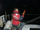
1) What do you do to the boat on watch? On watch the primary duties are looking out for traffic, monitoring course, and trimming sales. Since we have radar and AIS a scan of the horizon for lights and a walk below to look at the screen every 15-20 minutes has you covered here. An occasional look at the compass to verify course and the autopilot to make sure it's still engaged and not displaying any error codes. Early on in the trip the autopilot was faulting randomly and turning itself off. The boat was often sailing itself for a while before we found out. This issue should be resolved now but better safe than sorry. If you do get a wind shift you may need to trim the jib, main, or mizzen to correct the sails. The winds are fairly constant so I haven't made many changes at night since everything is still dialed in from sailing during the day.
2) Can you upload more pictures? Right now we're doing the posts by sending an email into the blog over the satellite. Sending pictures would be pretty slow and eat up too much satellite time for now. The pictures up there now were uploaded with my cellular card while we were still in range of Hawaii. I am taking lots of pictures and will upload them when I'm in range again.
3) Have you seen any whales? Not yet. Eric was telling us a story today of how he dodged some to avoid hitting them in last years Victoria to Maui race. They should be in this area though so our eyes are peeled.
We're at about the same latitude as LA now, so definitely making progress in the right direction. 1:00AM-3:30AM watch tonight. Should be interesting since we decided to leave the spinnaker up and it's a little more finicky if the wind pipes up overnight. The forecast shows no more than 15 knots so hopefully that holds true. Under sail we're doing 7 to 8 knots pretty consistently. Motoring is usually at 6 knots so it's nice to be going faster. Hopefully this will hold out for the remainder of the trip!