Faule Haut on her circumnavigation / Faule Haut auf ihrer Weltumsegelung
Who: Skipper Ingo Patalla
Port: Vinaròs, Spain
09 February 2019 | Opua, New Zealan
26 December 2018
07 December 2018 | Anchorage at Rangiroa, Tuamotus, French Polynesia
30 November 2018 | Rangiroa
27 November 2018 | Sailing from Fakarava to Rangiroa, French Polynesia
21 November 2018 | Fakarava, Archipel des Tuamotus, French Polynesia
15 June 2018 | Null Wind. Blick auf Panama City von meinem Ankerplatz.
14 June 2018
13 June 2018 | Balboa Yatch Club
11 June 2018 | Balboa Yatch Club
Faule Haut in New Zealand
09 February 2019 | Opua, New Zealan
Ingo Patalla
06.02.2019
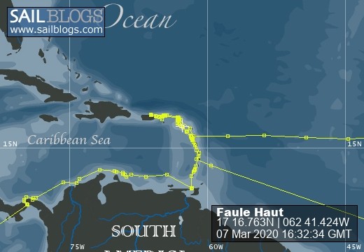
Faule Haut has reached New Zealand.
After having spent six days at the Kingdom of Tonga, Faule Haut left the island Tongatapu on Jan. 29th, 2019 and reached Opua, (northern) New Zealand on Feb 6th, safe and sound. This was Faule Haut‘s fastest passage so far. She covered the distance of 1,025 nm within 8 1/2 days, averaging a speed of little over 5 kn. Windspeed was mostly above 25 and 30 kn, so that the sails had to be reefed almost permanently. High waves and gusty winds from abeam made it a tough ride. Wind and waves – which the autopilot often could not handle. It quit working often and made the nights a drag. Jumping on deck in the middle of the night because of an alarming and not functioning autopilot is no fun and wears you out after a few nights. Sleep deprivation is the hardest thing to endure when singlehand sailing and has exhausted Skipper Ingo up to the max. But now he has dropped the anchor in a beautiful bay at LAT 35° 07.022’ S, LON 173° 58.931‘ E, close to Opua, and is looking forward to meeting the Kiwis – but first … sleeeeeeeep.
Oh – I almost forgot:
SOMETHING TO CELEBRATE
Faule Haut has left her home port Vinaròs, Spain, on Nov. 4th, 2017. Vinaròs is located close to Longitude 000°, the Greenwich 000°-meridian. She sailed westward, which means longitudes were „W“ and counting upwards. On Jan. 23rd she crossed the International Dateline close to Tonga and on Feb. 2nd she crossed LON 180° W which is likewise LON 180° E.
This means, that SHE HAS NOW COMPLETED HALF OF HER PLANNED CIRCUMNAVIGATION OF THE GLOBE,
being on her cruise for one year and three months and two days (or 459 days).
From now on LON figures are „E“ and … counting backwards.
Feels like the skipper is sailing home now.
Skipper is sailing singelhand. Two free double berths available.
CRUISINGPLAN as of 06.02.2019
Right now I am in New Zealand. I am on a circumnavigation that I started singlehand at Vinaros (Barcelona), Spain, on the 4th of Nov. 2017..
Because I spent a huge sum on repair/maintainance/improving of the boat, I am willing to take on guests to help me finance this cruise. You can either join for two week on the boat or you even stay on the boat for over a year and a half and come with me up to Spain.
Two double berths available. This means I could host two guests – each gets his own cabin – or if two person share one cabin, I could host four guests.
Here is my cruising plan which is not 100 % fixed. If you stay on the boat longer than a couple of week, I am willing to change this plan according to your wishes (within a limit).
CRUISINGPLAN as of 10.02.2019
SUBJECT TO CHANGE (nm = nautical miles, d= day)
22.02.19 departure New Zealand
1,200 nm 15 d
09.03.19 arrival Sidney, Australia
25.03.19 departure Sidney
1,800 nm 21 d
15.04.19 arrival Torres Strait
17.04.19 departure Torres Strait
1,800 nm 21 d
08.05.19 arrival at Java, Indonesia
(sailing Malaysia, Indonesia, Malaysia, Thailand in June, July and August 2019; my wife might come on board for a few weeks)
30.08.19 departure of the area around Indonesia, Malaysia, Thailand
3,300 nm 37 d (crossing the Indian Ocean)
06.10.19 arrival Mauritius
10.10.19 departure Mauritius
400 nm 5 d
15.10.19 arrival Réunion
19.10.19 departure Réunion
400 nm 6 d
25.10.19 arrival Madagascar
03.11.19 departure Madagascar
1,600 nm 20 d
23.11.19 arrival South Africa
03.12.19 departure South Africa
5,720 nm 65 d (crossing the Atlantic towards the Caribbean)
06.02.20 arrival (Guadeloupe or another island of the Lesser Antilles)
15.02.20 departure Guadeloupe
…..
most likely going to Dominican Republic, Haiti, Cuba and Bob Marley
before heading back to Vinaròs, Spain, Mediterranean via Bahamas and the Azores
(Edit)
Zum Seitenanfang
NEW CRUISING PLAN
26 December 2018
CRUISINGPLAN as of 24.12.2018 - SUBJECT TO CHANGE
Right now I am at Raiatea, French Polynesia. I am on a circumnavigation that I started singlehand at Vinaros (Barcelona), Spain, on the 4th of Nov. 2017..
Because I spend over 10,000 € on repair/maintainance/improving of the boat, I am willing to take on guests to help me finance this cruise. You can either join for two week on the boat or you even stay on the boat for over a year and a half and come with me up to Spain.
Two double berths available. This means I could host two guests - each gets his own cabin - or if two person share one cabin, I could host four guests.
Here is my cruising plan which is not 100 % fixed. If you stay on the boat longer than a couple of week, I am willing to change this plan according to your wishes (within a limit).
CRUISINGPLAN - SUBJECT TO CHANGE (nm = nautical miles, d= day)
—————————————
25.12.18 departure Raiatea
50 nm 1 d
26.12.18 arrival Bora Bora
——-
30.12.18 departure Bora Bora
40 nm 1 d
31.12.18 arrival Maupiti
——-
02.01.19 departure Maupiti
1,340 nm 17d
19.01.19 arrival Tonga
——-
25.01.19 departure Tonga
1,020 nm 13 d
07.0 2.19 arrival Opua, Northern New Zealand
——-
22.02.19 departure New Zealand
1,020 nm 12 d
06.03.19 arrival Sidney, Australia
——-
25.03.06.19 departure Sidney
1,800 nm 21 d
15.04.19 arrival Torres Strait
——-
17.04.19 departure Torres Strait
1,800 nm 21 d
08.05.19 arrival at Java, Indonesia
(sailing Malaysia, Indonesia, Malaysia, Thailand in June, July and August 2019; my wife will come on board for a few weeks)
——-
30.08.19 departure of the area around Indonesia, Malaysia, Thailand
3,300 nm 37 d (crossing the Indian Ocean)
06.10.19 arrival Mauritius
——-
10.10.19 departure Mauritius
400 nm 5 d
15.10.19 arrival Réunion
——-
19.10.19 departure Réunion
400 nm 6 d
25.10.19 arrival Madagascar
——-
03.11.19 departure Madagascar
1,600 nm 20 d
23.11.19 arrival South Africa
——-
03.12.19 departure South Africa
5,720 nm 65d (crossing the Atlantic towards the Caribbean)
06.02.20 arrival (Guadeloupe or another island of the Lesser Antilles)
——-
15.02.20 departure Guadeloupe
.....
most likely going to Dominican Republic, Haiti, Cuba and Bob Marley 🤗 before heading back to Vinaròs, Spain, Mediterranean via Bahamas and the Azores.
Crew is leaving
07 December 2018 | Anchorage at Rangiroa, Tuamotus, French Polynesia
Ingo Patalla
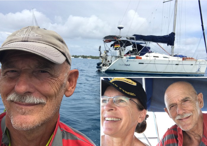
Some people wanted to see a picture of my crew. First, Cecilia did not want appear on the website. Now she asked me to put a picture of the Faule Haut and her on it.
Here it is.
But Cecilia will leave tomorrow. No more woman on board. Nobody there anymore to cook or tell the skipper how life works.
Will he starve now?😱 Will he survive?😱
Stay tuned - and he will let you know.
The skipper is looking forward to continuing his cruise, enjoying his freedom, sailing singlehand⛵️ and nude through the South Pacific, peeing freely over the railing - confident, that he will make it. 😉🤣
Invitation to sailing through paradise.
30 November 2018 | Rangiroa
Ingo Patalla
I still have a double berth available. So why don’t you hop on a plane and get here.
You can sail inside the Archipel des Tuamotus with us.
French Polynesia, the most beautiful place in the world for sailing. I will be in this area until February.
You never get such a chance to sail through paradise.
From February on, I will even have two double berth free. So you might bring your friends along.
Skipper Ingo
on sailboat Faule Haut,
Rangiroa, Archipel des Tuamotus, French Polynesia.
The Less-Than-10 Seconds-Catch.
27 November 2018 | Sailing from Fakarava to Rangiroa, French Polynesia
Ingo Patalla
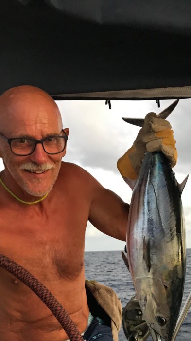
27.11.2018. The "Less-Than-10 Seconds-Catch".
No kidding.
In the evening on the first day when we left Fakarava sailing to Rangiroa (Archipel des Tuamotus, French Polynesia) short before sunset I got the fishing rod out, knowing that this would be the best time to catch something.
I threw the lure in the water and started to release some fishing line, just thinking how much line I should release. No need for thinking anymore. The line started to spin off the reel like crazy. I had a fish on the hook in less than 10 seconds.
Cecilia is my witness.
There was so much tension on the line and the reel came off the rod. Some attachment broke off. I almost lost my catch. Unable to wind up the line with the reel without the fishing rod, I wrapped the line around the winch and winched the fish towards the boat.
I cleaned it and put it in the freezer. Next morning Cecilia sliced that delicious tuna fellow in pieces and we already had tuna steaks three days in a row, including today. And guess what we gonna eat tomorrow?
I think I will never top this fishing time in my life.
Faule Haut nearly totally crashed on a coral reef inside the atoll Fakarava.
21 November 2018 | Fakarava, Archipel des Tuamotus, French Polynesia
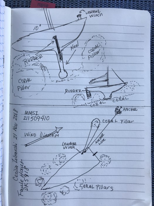
FAULE HAUT almost totally crashed on a coral reef at Fakarava, on an atoll belonging to the Archipel de Tuamotus, French Polynesia..
I'm not dramatizing.
This is what happened:
We (crew Cecilia and I) ran aground on an unmarked and uncharted (and to us invisible) coral reef on Wednesday Nov. 21st in the afternoon at 02:45 h in Position LAT 16o 29.091S, LON 145o 26.608W
I would like to have this whole scenario on a video, because its indescribable.
We were under sails, tacking/zigzagging inside the atoll of Fakarava heading north with a speed of 4.5 to 5 knots.
All of a sudden we heard a grinding sound and the boat slowed down, moving its way up on a coral reef. We got stuck. We hurried to get the tension out of the sails and got them down and rolled up. We had come to a full stop within two and three seconds. Immediately I grabed my snorkel and goggles and jumped into the water to inspect the situation under the boat.
Faule Haut's guardian angel did a great job.
Too bad, I don't have pictures of what it looked like underneath the boat:
We went up on the reef between two coral heads, one on port and one on starboard, each just one meter away from the hull. Had our course been one meter further to port or starboard, we would have crashed the keel against one of these high coral heads that stood there like pillars up to about about 1 m under the water surface, 2 m in diameter. That would have been the death of Faule Haut. The narrow space between these heads was going up slowly like on a hill. That way the boatspeed was reduced slowly (more or less). I estimate, Faule Haut was lifted about 50 cm upwards.
Cecilia helped me to get my second (spare) anchor in the dinghy and I motored 20 meter behind the boat, a little off to starboard. There I dropped it. The end of the anchor rope I wrapped around the winch. I started winching us back the way we came. Well - I tried. It did not work. The tension on the rope was to tight. The anchor started dragging, as I expected. But at least it prevented the boat from being lifted up even more on the reef by the waves and from moving to port against the coral pillar.
I got two more ropes out and tied them together and swam to the corel head that we passed on the starboard side. I wrapped the ropes around the coral head and brought the free end back to the boat. Cecilia wrapped this rope around the winch and started to winch us back. It did work for about 30 or 40 cm, but then it stopped.
I put my googles on and dived down again to inspect the situation. We had to get back a little to starboard in order not to hit the rudder against the coral head on the port side. So I advised Cecilia put more tension on the rope via the winch while I jumped back in the water and told her to motor backwards under full throttle. I was watching underneath the boat, that our rudder does not touch one of these coral heads. Cecilia did great in following my instructions to where to go and where to turn the rudder. Only me underneath the boat could see the coral heads and the way to get out between them. So Cecilia depended on my instructions. She was handling the steering wheel and the winch at the same time to keep tension on the rope around the starboard winch. It worked. Slowly the boat slid down the reef backwards while the rope that was wrapped around the coral head on starboard kept us from moving against the other coral head on port.
We got free. I did inspect the boat underneath for damage. I could not find any, except some scratches on the bottom of the keel and - of course - there is no more paint on the bottom.
The most important thing: The rudder did not have any contact with the corals. If that had happened, the rudder would have been crashed, broken off or at least bent, leaving us unmaneuverable.
From what I experienced so far on my cruise (I left my home port in Spain more than 12 month ago), I think my guardian angel has been putting in lots of overtime working 24/7 . Looking forward to meeting him one day eye to eye and shake hands with him.
Unlimited thanks and praise to my Lord Jesus Christ for assigning such a skillful vigilant one to me. He knew best what I needed.
Cecilia made this sketch for better understanding.
In the Doldrums already. In der Flaute gefangen.
15 June 2018 | Null Wind. Blick auf Panama City von meinem Ankerplatz.
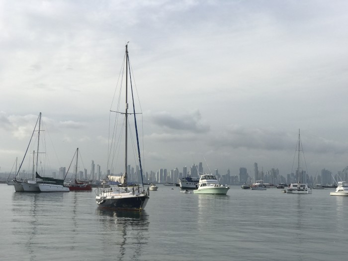
Actually, I was gonna be on my way to Pitcairn Island, but I already got stuck in the doldrums. Looks like they started already here at Panama. I’m already to close to the equator.
Well - that’s sailing.
According to my weather map, I would find wind about 600 nm further south. But I’m on a sailing boat. I can’t motor down south for six days. Ain’t got no other choice but to wait for the wind/weather to change. But the forecast is not in my favor. I might be stuck here for a few days.
I moved to another anchorage, because I was lookin for Wifi.
Currently I’m in a bay facing Panama City, as you can see on the picture. The sea is flat. No wind going at all.
Kinda tricky. I drove very slowly along the coastline checking permanently my water depth and my smartphone WLAN settings.
Right now I’m just 150 ft from the shore anchoring and picking up a free Wifi with my super duper “Bad Boy Antenna”, which I bought and installed at Saint Martin. .
I’m a lucky guy. A little bit risky though, being so close to the shore, because of the water depth. For staying overnight, I will have to anchor further out.
OK. That’s it.
As soon as you won’t hear anything from me, you know that I have left this spot heading to Pitcairn.
—————————————-
Eigentlich wollte ich seit gestern Richtung Pitcairn unterwegs sein, aber ich bin hier gefangen in einer Flautenzone. Die See ist glatter als ein Babyarsch. Null Wind.
Wetterbericht sagt nix gutes. Kein Wind die nächsten drei Tage.
Erst 600 sm weiter südlich gibt’s Wind. Aber ich kann ja nicht 600 sm Motoren. Ich bin auf einem Segelboot.
Bin auf einen anderen Ankerplatz gewechselt, weil ich gehofft hatte hier freies Wifi zu finden. Dazu bin ich ganz langsam an der Küste (gegenüber Panama City) entlang gefahren, immer mein Blick auf das Echolot um die Wassertiefe zu checken, dazu gleichzeitig auf meine Smartphone WLAN Settings um ein freies WLAN zu finden.
Bingo! Hat gefunzzt.
Für die Nacht werde ich weiter draußen Ankern, denn momentan bin ich nur 50 m von der Küste entfernt. Bisschen riskant.
Sobald ihr nichts mehr von mir hört, wisst ihr, ich bin unterwegs nach Pitcairn.
Bis dann.
Skipper Ingo, Faule Haut, Panama City.
Distance to Pitcairn 3,600 nm / Luftlinie 3.600 sm.
14 June 2018
Skipper Ingo
The Pacific - covering about a third of the entire area of our planet. It's the greatest of all oceans. It's wider than the Indian Ocean and the Pacific all together.
The east-west range covers about half the circumference of the earth.
Ahead of me lies the longest cruise and the longest distance of all legs on my circumnavigation.
------------------------------------------------------
Der Pazifik. Er bedeckt ca. 1/3 der Erdoberfläche. In ost-west Richtung überspannt er an seiner breitesten Stelle den halben Erdumfang. Er ist größer als der Atlantik und der Indische Ozean zusammen.
Vor mir liegt die längste Etappe meiner Weltumsegelung
Wish me luck !
What's next? / Wo geht‘s hin?
13 June 2018 | Balboa Yatch Club
Skipper Ingo
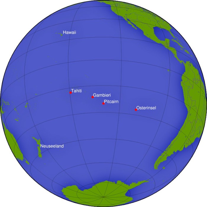
to Pitcairn Island
Home of the descendants of the Mutineers of the Bounty. Considered to be one of the remotest islands in the world.
-----------------------------------------------------
Nach Pitcairn Island.
Pitcairn ist die Hauptinsel der Pitcairninseln (englisch Pitcairn Islands) und liegt im Pazifik, etwa 5000 km von Neuseeland und rund 5400 km von Südamerika entfernt. Sie ist die einzige bewohnte Insel des Archipels. Weitere Inseln der Gruppe sind Oeno mit dem dazugehörigen winzigen Sandy Island, Henderson und das Atoll Ducie. In der Kreolsprache, dem Pitcairn-Englisch, heißt sie Pitkern.
Die Einwohner sind großteils Nachfahren der Meuterer von der Bounty und ihrer polynesischen Frauen.
Fletcher Christian, der Anführer der Meuterei, hielt die Insel für den geeigneten Zufluchtsort vor den britischen Schiffen, die die Admiralität zur Festnahme der Meuterer entsenden würde. Die insgesamt neun Europäer, sechs polynesischen Männer und zwölf polynesischen Frauen sichteten die felsige Insel am 15. Januar 1790. Die acht Briten, die Christian begleiteten, waren der Seekadett Edward "Ned" Young, die Matrosen John Adams alias Alexander Smith, Isaac Martin, William McCoy, John Mills, Matthew Quintal, John Williams und der zweite Gärtner William Brown. Sie konnten aber wegen der starken Brandung erst drei Tage später mit einem Beiboot anlanden
Pitcairn wurde am 2. Juli 1767 von dem Seekadetten Robert Pitcairn, Sohn des Marineoffiziers John Pitcairn, entdeckt und ist seit 1838 britische Kronkolonie bzw. britisches Überseegebiet. Die Pitcairninseln sind die letzte britische Kolonie im Pazifik.
Heute wird Pitcairn durchschnittlich vier- bis sechsmal im Jahr von einem Containerschiff angelaufen, das die lebensnotwendigen Güter und Post überbringt. Gelegentlich kommt auch ein Kreuzfahrtschiff zu Besuch
Pitcairn hat keinen Hafen.
Die Schiffe liegen jeweils auf Reede und die Güter werden in oft gefährlichen Manövern mit den beiden rund zwölf Meter langen Aluminium-Arbeitsbooten (Longboats) der Pitcairner überstellt
Das abgelegene und nicht erschlossene Pitcairn ist nur schwierig zu erreichen. Die Versorgungsschiffe ab Neuseeland fahren unregelmäßig und nehmen Touristen nur in Ausnahmefällen mit. Kreuzfahrtschiffe suchen mehrmals im Jahr Pitcairn auf, sie liegen vor der Insel auf Reede, und die Pitcairner kommen, wenn das Wetter es erlaubt, mit ihren Booten an Bord, um Souvenirs zu verkaufen. Das Ausbooten von Passagieren ist wegen der starken Brandung oft zu gefährlich, sodass die meisten Kreuzfahrtpassagiere sich mit einer Umrundung der Insel begnügen müssen. Eine weitere Möglichkeit, die Insel zu erreichen, ist das Chartern einer Hochseeyacht in Tahiti oder auf den Marquesas.
Hauptattraktion ist wohl die Insel selbst mit ihren Bewohnern und das Wissen, zu den wenigen Menschen zu gehören, die Pitcairn jemals betreten haben
------------------------------------------------------------------------
We had that before (Atlantic crossing). / Das hatten wir doch schon mal.
12 June 2018
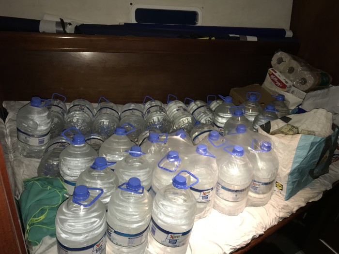
My water bed.
Not enough room for all the food and equippment.
--------------------------------------------------------
Mein Wasserbett.
Ich weiß kaum wohin mit dem Proviant.
Not enough room for all the food and equippment.
--------------------------------------------------------
Mein Wasserbett.
Ich weiß kaum wohin mit dem Proviant.
| Vessel Name: | Faule Haut |
| Vessel Make/Model: | Beneteau Oceanis 393 Clipper |
| Hailing Port: | Vinaròs, Spain |
| Crew: | Skipper Ingo Patalla |
| About: | Mostly no crew on board. Skipper sails singelhand. Crew places are available. Boat has two free double berths. Come on and join. |
| Home Page: | http://www.faule-haut.de |
Faule Haut's Photos - Main
 |
Vorbereitungen für die Fahrt nach Pitcairn
5 Photos
Created 12 June 2018
|
|
Faule Haut on her circumnavigation / Faule Haut auf ihrer Weltumsegelung
Who: Skipper Ingo Patalla
Port: Vinaròs, Spain