A Belize Adventure
A Belize Adventure
05 January 2013 | The Islands along the Belize Reefs
Nick
Chapter 1 - Caye Caulker to St. Georges Caye
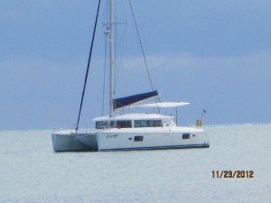
Day 1 - Friday, November 23rd
We started our redeye journey just after midnight early Friday morning, November 23rd, on United Airlines UA132, out of SFO (37.6190° N, 122.3749° W) with a destination to Belize City (17.4964° N, 88.1828° W), Belize. We arrived in Belize City at 11:19am and boarded Tropic Air Flight 60 for the island of Caye Caulker (17.7425° N, 88.0250° W). The Tropic Air aircraft are single engine, turboprop, Cessna Caravan’s capable of transporting a total 12 passengers with three single seat rows on the left side, three double seat rows on the right side, and three seats in the last row. The flight from Belize City was our first image of our targeted sailing journey and all passengers had a great view out their window. Flying at an altitude of not more than 1500 feet, we visualized transparent and shallow water, mangrove and sand-edged islands, coral heads, sand and grass sea bottoms, the barrier reefs, and of course the Caribbean’s open ocean water to the horizon. When we landed in Caye Caulker, it felt like the wheels were inflated to 1000 pounds as we bounced down the runway between two rows of densely planted vegetation that barely seemed to avoid the Cessna’s outstretched wings. Once on the ground and looking back at the dirt airstrip it looked like it was just barely long enough for our little Cessna Caravan.
As we deboarded the Cessna we were immediately greeted by Devlin, the Belizian Tropic Air employee that Patty hired for a water taxi ride from the air strip to around the island and to the anchorage where the catamaran, Avanga, was waiting for our arrival. The air strip was hot and we sweltered while we waited. Finally, when Devlin announced our water taxi had arrived, with luggage in tow we walked across the airstrip, through a small cemetery near the shore, and then to a rickety dock where we walked some 150 feet along weather worn, warped, dangerously thin, buckling planks that bent towards the Caribbean Ocean under the combined weight of each sailor and their luggage. We spaced ourselves appropriately so as not to overwhelm the weak planks. Each step was a balancing challenge and a deliberate progression. Getting down into the Yamaha driven 18 foot wooden fishing board, our so called water taxi, was just the same. The dock towered above the little boat and presented quite a drop to our intended seat; there were no seat belts I noticed. The luggage took priority and nearly filled the boat. However, we all made our way safely into the boat without any excitement, avoiding all the luggage and the large red gasoline tank in the middle of the craft. The bottom of the boat was dry and so was our fabric luggage, at least for now. The boat smelled like gasoline.
Our Belizian taxi crew was extremely friendly and very talkative throughout the journey, providing us with some history of Caye Caulker and about their personal lives. Devlin moved to Caye Caulker from Belize City to work for Tropic Air and the captain of the water taxi lived his whole life in Caye Caulker which now boasts a population of 1300. Since Belize is a former British colony, the official language of the Belizian's is English even through Kriol is the first language of 33% of the population and Spanish is the first language of 46% of the population. So far, English hadn’t been an obstacle for us.
Alan and Patty traveled to Belize the previous Sunday. They spent a couple of nights in San Pedro, Ambergris Cay relaxing and enjoying the scene some and then on to do the provisioning for our catamaran, hiring a skipper for the first leg of the journey without us, and then departing for Caye Caulker on Wednesday on the Avanga. They would wait there until we arrived. On Caye Caulker, Alan and Patty finished the provisioning of fresh fruit and vegetables with a woman they labeled Marge Simpson. The street merchant, a Canadian woman with a Belizian husband and three little children, the youngest of which was held in a sling that hung on her chest, sold her wares on main street in a little wooden stand of sorts, quite common on Caye Caulker’s main street. She got her tag from the swirl of hair that swooped up into a beehive hairstyle nearly matching that of the matriarch of the Simpson cartoon family.
As we rounded the island and motored into the anchorage, Patty was there to greet us. There was one other catamaran at anchor. After securing permission to come aboard, the new arrivals settled into the Avanga, a 42 foot, 2008 Lagoon 420 catamaran, picking a stateroom, unpacking, filling the heads with toilet paper, and touring the rest of this grand ship. At the same time Patty negotiated a dozen lobster from a local Belizian fisherman who paddled by in his tiny wooden canoe to sell his goods. Alan arrived moments later in the Avanga’s dingy with a case of Pelican Beer from a Belizian beer distribution company on the island. Pelican Beer, a local beer, is brewed somewhere in Belize.
Not long after we downed our first round of chilled Pelican beers, which by the way is a very good brew, we pulled anchor and got underway. Pulling the anchor, however, proved to be a quite a chore taking almost 45 minutes. We stalled one of the twin diesel engines making boat management very difficult, well almost impossible. Once we realized the lack of a functional propeller was the problem, we started the port engine and the crew persevered. Once the anchor was cleared, we were are on our way. Our first destination was St Georges Caye (17.5531° N, 88.0739° W). Since we were getting a very late start in the day, we decided to motor south since we needed to get through the dreaded Porto Stuck (17°37'0" N and 88°6'0" W) and anchored at St Georges Caye well before sundown.
It is a requirement to visually navigate the shallows along the islands of Belize. The charter company, TMM, recommends anchoring in daylight to both avoid running aground and for successful anchor setting. It did’t take us long to respect that requirement.
Getting from Caye Caulker to St Georges Caye was a navigation challenge. We relied on paper charts, Alan’s Nobeltech navigation software on his Toshiba laptop, Alan’s Garmin ETREX handheld GPS, and the onboard Raymarine E120 chartplotter that was located at the navigation station in the galley. I thought the Raymarine should be located at the helm because of the reputation of the shallow waters along the charted routes but it wasn’t. We also relied on visual sighting, the depth finder, and the other instruments as the passage was very shallow and tricky to navigate. I was totally freaked out about shallow water but should I be?
As we passed by the red tower along Porto Stuck I thought we were home free. But where were the “sticks” that we read about in the Belize cruising guide; they are supposed to be on our port side. Then we spotted them, off our starboard side and the Raymarine depth gauge was already reading zero. We were off course! We looked over the starboard side of the helm and could clearly see the bottom before we feel a slight drag, then another drag. We ran aground but we were still moving. Behind each hull was a muddy, sandy trail, a clear sign we were dragging the bottom. We immediately changed our heading toward the “sticks”, changing fear to hope for deeper water. I held my breath and finally exhaled when we found ourselves safely on the favorable side of the famous sticks. The depth gauge cooperated and jumped to 1-2 feet, enough margin to eliminate my terror.
A few hours later we arrived at St George’s Caye where anchoring went very well. Alan managed the helm and Patty the anchor pendant. I managed the anchor drop and attempted to hand-signal Alan to keep the bow facing the anchor chain for a clean drop. With only 5-6 feet of depth at our anchorage, it was quite easy to accomplish the 7:1 ratio of anchor rode to depth. On Avanga, the anchor rode is all chain so a little plastic tie wrap was added at the most strategic chain link to mark the proper anchor rode length and the best point to attach the anchor rode bridle. Only after the bridle was attached, and we floated downwind to rest on the bridle, did we reverse the engines to set the hook for the night. Three TMM Cats now lined the anchorage, Felicity off our starboard side and Toucan off their starboard side. With the primary plow anchor set, it was time to drop the secondary anchor. This was our home for the night.
The secondary anchor, a safety backup anchor, required Alan to motor forward towards the direction of the evening’s wind. Once in position, I dropped the Danforth anchor by hand and carefully let out the anchor rode, a combination of chain and rope. Once the second anchor was strategically sitting on the sea floor, the Cat was carefully reversed, and the anchor was set by tugging hard on the anchor rode and then slacked until the Cat once again settled downwind on the tension of the main anchor’s bridle. Once that was accomplished, the slack of the secondary anchor was resolved and secured to a deck cleat using a cleat hitch. Now we were good to go for our first overnight anchorage. It’s was time for a Pelican beer.
The evening hours started with a fine dinner of lobster and snapper, wild rice and zucchini. Our executive chef, Bert, did a great job with the sides while our Sous Chef, Alan, labored over the stanchion mounted hot BBQ pit grilling the fresh seafood. After dinner was VSOP Cognac and South American Cognac soaked cigars for the guys who were banished to the upper deck as the wind howled and we barely kept the cigars alive. It took more than a couple flame thrower attempts to keep mine going. Bert and Alan reported some issues as well.
We capped off the evening with Darlis, Linda, Patty, Bert, Alan, and I all talking on the back deck, reflecting on the day, and watching the stars under a canopy of clouds. The big stars were bright but no constellations would be seen on this night. The winds did not subside.
The Toucan and Felicity were strangely quiet all night. Then, in the dark of the night, we saw a bright light rounding the Western side of the island heading toward the Avanga. It was a dingy and a flashlight. They had dinner on the island. As they edged closer we could hear the roar of their little outboard motor. The dingy ride looked wet and cold as they headed into the wind toward their Cat. Little did we know. The dingy passed Avanga’s bow and soon after their crew climbed onto their Cats stern. They were safely home for the night. The wind was still howling.
In the late evening, many hours later, off in the distance towards the coral reef, a tiny sail was barely illuminated by the evening’s seven eights moon phase and headed towards the Avanga. We continued to watch the bright white sail for some 30-40 minutes until we saw the outline of a small wooden monohull of Belizian origin with a stern mounted but silent outboard motor, a single sail, and seven men aboard. They sailed slowly past Avanga and landed safely under sail at the docks. The sailboat, which was actually a fishing boat, could not have been more than 18-20 feet long. On each side of the little sailboat was a stack of three little fishing canoes. Obviously maned by local fishermen, the crew of seven men somehow slept on their boat or maybe on the dock. When the excitement was over we all retired to our staterooms.
Chapter 2 - Dinner at Spanish Lookout Caye
Day 2 - Saturday, November 24th
After a very windy and shifting night at anchor, the Avanga rotated with the wind to a completely different position and direction from where we originally anchored. The anchors held perfectly while the winds moved from a northernly to easterly blow, moving our boat’s direction in the wind some ninety degrees different. In anchorage Toucan and Felicity were still anchored next door.
We all started the day with cup of coffee and watched Felicity, the 38 foot Lagoon 380, get underway. It was about 8:00am. We waved them good bye. We decided, however, to walk the island of St George, a sort of sight seeing trip. The island was long and narrow, about 150 yards wide. We could see the ocean on both sides at the same time. It took us about 15-20 minutes to walk the length of the island.
There were a number of homes on the island, many with realtor signs, and only a few inhabitants. We encountered a Belizian man in his backyard who told us that most of the residents of St Georges Caye were on the mainland in the off season. The island looked uninhabited. However, there was a resort on the island and a restaurant that Toucan used the previous evening.
St Georges Caye Resort, the islands sole resort, was where we found all the islands action. The tiny resort sported a collection of little cabin huts with thatch roofs both on the water and inland. A Belizian resort worker was busy raking the beach of debris and combing the sand, something he said he does every morning. We found the restaurant bar and met some folks who are visiting the island from the mainland. We engaged in a short chat and determined they were staying in the private home right next to the resort. They encouraged us to visit Placentia but it is not part of our plans.
The island resort is touted as a secluded paradise getaway and that was definitely evidenced by the three couples we found staying at the hotel. If you want a quiet respite in late November, St George's Caye Resort is your place.
We departed St Georges Caye with a charted course to travel east of Drowned Cays along the barrier reef. We raised the sails and made our way east of Gallows Point until we arrived at Shags Bluff. While sailing to Shags Bluff we were greeted by three very large Dolphins that raced along our boat for some 8-10 minutes. As we entered the lagoon we needed to avoid the sandy shoal the charts characterized at two feet in depth; navigation was again tricky. We found a clean, safe spot, and anchored for lunch. Once at anchor we never saw the Dolphins again. We all enjoyed lunch and swam for a while in very strong currents without waiting for the required thirty minutes for our food to settle.
Our next destination was Spanish Lookout Caye (17°24'0" N 88°4'0" W), a privately owned island of 186 acres. The trick was to navigate the narrow channel and stay aware of shallows, shoals, lobster sticks, and any other obstacles as we headed past Farls Bogue for our western approach to Spanish Lookout Cayee. The passage was very deep, perhaps dredged, and as we popped out between the islands, we could see the mainland maybe twenty miles away. The water was deep, we were sailing fast, and the water was vast. We now had wide open sailing with beautiful, relatively open seas. We sailed for a couple of hours. It was fantastic.
As we approached Spanish Lookout Caye, we unexpectedly met up with the Toucan and followed them into the anchorage. Patty hailed the Toucan on VHF channel 8 and their skipper, John, warned us of lots shallows in the anchorage. Duh! They anchored first and we followed directly behind. The first and main anchor dropped perfectly but as we motored 90 degrees to port to drop the secondary anchor, we ran aground. The Raymarine depth gauge measured zero. We were stuck. Alan skillfully reversed the twin diesels towards the first anchor location and got us unstuck. Whew! No big deal! We paused, floated downwind, rested on the bridle, and then trimmed the secondary anchor rode for the evening’s anchorage. We all opened a Pelican beer and relaxed on the back deck for a couple of hours. It was time for some music.
The Avanga was outfitted with an iPod compatible stereo system with speakers strategically located speakers in the galley and on the back deck. It was always decision time for who’s iPhone would be connected; who’s music library would be featured. My playlist, called Belize Vacation, included Boat in Belize by Kelly Mcguire, After the Storm by Bela Fleck, Come Away To Belize With Me by Island Jam, Harbour Lights by Boz Scaggs, High Water by Rush, Song of the Sea by Dan Fogelberg, Wooden Ships by Crosby, Stills, and Nash, Seagull by Bad Company, Sunsets by Sang Froid, well you get the picture. My playlist was a little exteme for the group so the other iPhones got the most attention.
Dinner was our next challenge. We had reservations, the restaurant was around the weather side of the island, and our water taxi was Avanga’s Suzuki powered inflatable dingy. It was already early evening and the wind was picking up and changing directions. All six of the Avanga crew climbed into the dingy. Heading into the wind the dingy ride was wet and the water near the island was shallow, so shallow that we ran aground momentarily, once or twice. The dingy produced that all too familiar wake of muddy water signaling Alan to head for deeper water. Bert was wearing a rain poncho and sat at the front of the dingy. He was safe. Directly behind Bert, my right side was completely drenched. I did a good job preventing the salty spray from reaching Darlis. When we finally reached the docks at the edge of the restaurant, we were immediately greeted by a Belizian staff member who helped us tie off our dingy. We waited for the Toucan crew who was right behind us at first but lagged long after we arrived; they got stuck too. The right cotton sleeve of my cotton tropical shirt was still dripping as we entered the restaurant.
Once in the restaurant we found there were 12 brand new cabanas on stilts over the water nearby and a gift shop next door that featured dive and snorkel gear. The signs in the gift shop described a full-service onsite PADI facility that promised diverse dive and snorkel tours.
Dinner was at the Belize Adventure Lodge, the first pink building with the white string lights bordering the windows. We were greeted by a staff of three. My pre-dinner drink was a Bombay Sapphire Gin and tonic. Yay! Gin was not part of our provisioning but still my favorite hard liquor. There were twelve sailors that emanated from the two dingy’s and we are lucky to have made reservations because we were the only ones in the restaurant. We were the only visitors on the island. We were virtually in the middle of nowhere on a tiny island having dinner with our fellow sailers, sewing yarns of trips gone-by, eating a delightful grouper dinner with red pickled carrots and a carefully formed mold of brown rice. It wasn’t exactly a gourmet quality dinner but nonetheless it was reasonably good; we were hungry. But at $25 per plate with gourmet restaurant proportions, it was definitely a vacation class dinner. Dinner was capped off with Key Lime pie. Darlis ordered chicken but no pie.
After a short tour through the tiny gift shop where we purchased some little items for our daughters, we all climbed back into out respective dingy’s for the ride back to the Cat’s. The dingy ride back to the Cat’s was downwind in the dark, a favorable direction. Although it was fairly dry ride with little spray, we rounded the island by a large margin to avoid the shallows along the island. The ride back was much longer. As we headed to our anchorage our only visual of home was the mast head lights of the two Cats; we used that for dingy navigation. Once we got closer, the white pontoons of each Cat glimmered in the moonlight, drawing our path to home for the night.
Chapter 3 - Spanish Lookout Caye to Colson Cay
Day 3 - Sunday, November 25th
When I woke up at the Spanish Lookout Caye anchorage I gazed at the tiny island to starboard through a side hatch of our cabin. I wondered who lived in the little white house on the island. The seas and wind were calm. I stood on our berth through the open overhead hatch and watched a large bird dive into the water, again to starboard, never to return to the surface. I watched the sunrise and headed to the galley for coffee.
We fiddled a little with getting the inverter power to the outlets. The switch was located in the cabin that Darlis and I selected and the crew was dependent on our timing. Coffee was more important than sleeping in. It finally worked or I finally figured out what to do and Bert flipped the switch on the coffee maker. I began to smell coffee and Linda set me up. Next was the smell fried potatoes and it was only 7:00am. The coffee tasted extra good today and everybody was now up and moving around. Next step was a hearty breakfast and planning the day. Our next destination was Colson Cay (16°27'0" N 88°18'0" W).
We set sail on the Western side of Spanish Lookout Caye and headed south, passing on our port side Water Caye, and then headed into the main channel for deep water. Yes, our Raymarine depth gauge found greater than 100 feet of depth, a luxury indeed. The wind was strong which quickly got the Cat moving along at greater than 5.5 knots. It was good to be sailing again. We continued sailing south past Middle Long Caye (17°16'0" N 88°4'0" W), Bluefield Range and Alligator Caye (17°10'60" N 88°4'60" W). At Alligator Caye we lost our wind so we powered up the twin diesels, and motored down into Colson Cays. We decided to round the southern tip of the island and anchor in a cove just south of the lobster camp displayed on our charts. We found the lobster camp was little more than a small wooden building on stilts, next to it another one of those rickety docks that looked like it had been abandoned for years. We successfully anchored on the leeward side of the island and found the wind was light and the seas were calm. We relocated ourselves on the bow for the first time, talking and preparing our first tropical drinks for the day. It would be Don Julio margarita’s for the girls and Pelican beer for the guys. We mellowed out for a couple of hours and turned up the music.
Except for the uninhabited lobster camp, the island looked desolate. There’s no restaurant on Colson Cay. There’s nothing on Colson Cay. We will definitely have dinner aboard the Avanga tonight.
At 4:00pm Bert started dinner, Darlis and Linda grabbed their books, and Alan, Patty and I jumped into the dingy to investigate potential snorkel destinations. Off our starboard side we immediately found DINK PASS and proceeded through a narrow mangrove lined path in shallows, over a grass carpeted floor only 1.5 to 2 feet deep, and finally ended up on the other side of the island. Once on the weather side of the island we found the sea was significantly rougher with a fresh breeze rolling over the tiny island. No snorkel zone was found though. Around again to the leeward side of the island we spotted only a couple of small coral outcrops, but lot’s of starfish. The highlight of the ride was the large swarm of flying fish the size of aquarium guppies that crossed the dingy’s bow. Our dingy trip did yield a new place for a Monday morning swim in shallow water near the leeward shore. It would be a place we never used.
Back on the Cat I worked on this blog, Bert made the evening’s salad, the ladies were still reading, Patty was just plain busy, and Alan was looking out towards the mainland at the beautiful sunset. He was up next to start the BBQ in calm winds, unlike two nights ago when the wind howled to provide a nearly instant red hot coal bed. It was a more sedate path to our fresh lobster dinner.
Dinner was excellent as usual, Lobster, brown rice, vegetable salad, and green beans. Dessert was dark chocolate with almonds. Indeed another luxury. We deserve those. We followed dinner with a round of hearts. It was a hard fought battle but in the end Patty took it for the team and exceeded the 100 point goal. It was not be to a cigar and Cognac night for the boys. I could tell Bert was disappointed.
As we buttoned up the Cat for bed time, we marveled at the lack of noise and the stillness of our surroundings. Only the occasional bird sang out now and a strangely faint bark coming from the completely deserted island.
Chapter 4 - The Shallow Water of Columbus Cay
Day 4 - Monday November 26th
Retiring to the cabin early has its advantages; I woke up to a sky full of stars. I popped up through the open hatch and just star gazed. As I expected, we were alone in our little sheltered bay. So much for the Flotilla of five catamarans each of which had been doing their own thing. The bay was flat and the wind was a mild steady breeze of 4-5 knots coming from the East. Back to the stars. Beautiful, bountiful, and vast. Overnight Orion shifted from Bow to Stern. As I continued to watch through the hatch, the horizon behind the mangrove island began to light up. The birds began to squawk. Even the faint bark of that dog fish called out over the whistle of the breeze. The stars slowly disappeared before my eyes until only the brightest were left and then they were gone too. The birds began to take flight and one flew by our bow on its morning hunt over the water. The last I saw it was still searching for its first meal of the day. Breakfast sounded good.
I sat in the galley with nearly a 360 degree view. I could see the mangrove lined island with 180 degrees of the view facing east. Clouds were hovering just above the water on the horizon, bright orange on the East and gray to black else where. The clouds looked like pulled taffy, swirling in the sky. The sun lifted above the horizon and it was too bright to look at anymore. It felt warm on my skin. It was time for some sunglasses. It was time for some sunscreen.
GPS navigation deserves an honorable mention as I reflect on the previous day of sailing. Without it we would not know where we are or where we are going. We rely on the charts and GPS to tell us where we are on those charts. Our brain has to merge a two dimensional chart with what we see visually and put it altogether. The typical water way navigation aids, like buoys, are relatively non-existent along the islands and its up to the skipper and its crew to interpret charts into three dimensional reality. At a distance and at various angles, the islands appear very different. Patience and faith in the navigation tools are key ingredients to successful navigation. Slowly it begins to sink in; yes, that island matches the charts and were heading in the right direction.
I heard a boat motor and looked all around our Cats perimeter to no avail. Must be the fishermen on the windward side of the island. Everybody was still asleep and I’ve already been up a couple of hours. The sun was now well above the horizon; it was 6:30am.
At 7:30am everybody was up and running. We enjoyed a yogurt and cereal breakfast, a side of watermelon and oranges, and of course coffee. We talked about the days trip in preparation for embarking on our journey. Just before our departure we saw a Cat near the northern island of Colson Cays. The Cat wasn’t marked and VHF didn’t give us any additional clues. It looked like they were anchoring to search for that snorkel location we never found. Our plan was Tobacco Cays. We didn’t know it then but that Cat was the Toucan.
After a short morning swim we headed out with the charted intention of sailing south along the reef around Columbus Cay (17°0'0" N 88°1'0" W) and Cross Cay (16°58'0" N 88°3'0" W). With all navigation systems set, we motored out through the channel that separated Colson Cay into two, just north of the lobster camp, and headed east on a route of 245 degrees true. On the way, we saw a huge animal which I believed was a manatee. At first it looked like a large patch of bottom sand but it was moving and when its tail breached the waters surface, we knew we had just seen our first pair of manatee. They quickly swam off our port bow and disappeared. Damn, we forgot our cameras.
Once in the main channel, which Raymarine measured at 10-12 feet deep, we turned south. Our first passing was Columbus Cay to the eastern reef side of the island. The wind was light to nonexistent so we had no choice but to motor our way down and wait for the wind.
Just as we passed abeam of Columbus Cay the depth gauge dived in value and concern set in big time. I was at the helm and Alan was watching forward to make sure we were in deep enough water. But then it happened. Just a bump at first, then another, and then another. Our depth gauge was reading zero and flashing.Then we ground to an abrupt halt! We ran aground! Again! We were stuck! Alan immediately took over the helm. I felt embarrassed. I drove us into this predicament. No time for that now.
The charts suck! The heading on the chart was 188 degrees True and changed to S-curve to avoid the shallows along the island and the shallows along the reef. The chart didn’t pick up a new heading until Cross Cay, the next island south. So, the route along Columbus Cay was purely a visual navigation. It was our job to find that narrow path where the charts indicated 6-8 foot depths.
The ocean bottom was sandy and grassy. No coral, no rocks, nothing bad, thank God. But it was shallow, very shallow. After trying to diesel power Avanga out of trouble with full throttle reverse to no avail it was time to take different tact. The tide was not on our side and would be at its lowest in two hours. Alan’s quick thinking of using the secondary anchor and the stern winch, primarily used to hoist the dingy, was that new direction. We grabbed the anchor from the forward anchor locker, headed aft, jumped into the dingy, and headed away from the Cat looking for deeper water. Once the water looked deep, may five feet, we dropped and set the anchor. As we returned to the boat, I looked up at the crew on deck and everybody looked calm, reassured that everything was under control. No panic.
Back on the stern, Patty and I managed the stern winch and Alan managed the twin diesel engines. We pulled the Cat free. In the chaos, the dingy was driven between the pontoons and the secondary anchor rode was extremely taught. Now panic was in order because we feared the anchor rode had fouled the starboard prop. With calm heads, we determined the line was around the starboard keel so I dove below the surface with the bitter end and it was free. Whew!
We headed south again along the same course looking for deeper water. The charts promised 8 foot depths along the island but 2-3 feet closest to the island and 3-4 feet along the reef but just how close to the island do we need to travel. Not more than 3-4 minutes later the dreaded bump bump bump and we were stuck again. We just couldn’t find that tiny thread of depth the chart portrayed. As I looked around the waterway ahead, I couldn’t see any deeper water and I wondered if we would ever get a positive reading on our depth gauge. Now concern changed to worry. Same plan again?
This time we decided not to use the dingy. There were no strong currents to worry about so Alan and I jumped off the stern of the Cat, grabbed the secondary anchor, and walked what seemed like a mile. It was only about 100 yards. Our objective was to set the anchor for our second attempt to free the Cat. We had already burned an hour at this point and low tide wasn’t far away. There was a sense of urgency. This time the winch pulled us free with very little help from the engines. We paused as we floated on both hulls with shallows all around us. Now what?
Alan and I looked at each other with the look that said lets get out of here. We turned the Cat north from where we came and Alan throttled up. The Raymarine depth gauge was still zero. The bumps were still there but intermittent. The muddy water followed the Cat. The throttle stayed on. As the twin diesel engines roared with a new route to travel around Columbus Cay to the north, I could almost hear a sigh of relief from the crew. I certainly heard my own. The depth gauge stabilized at 0.0 then 0.5, then 1.5, then 2 and growing. Were we safe now?
Around Columbus Cay we set a course to pass Cross Cay on the reef side of the island. Here we go again. With careful navigation, which had never been our problem, we successfully passed Cross Cay with Tobacco Cay (16°52'60" N 88°3'0" W) in full view. After an hour under power, to our starboard side was a Cat. Was it the same Cat we saw anchored at Colson Cays or the Toucan. Patty turned on the VHF radio and hailed the Toucan. It was one in the same. It was the Toucan that anchored at Colson Cays. As both Cats approached the anchorage, Avanga dropped anchor first and Toucan quickly followed.
Everybody on both Cats dingy’ed onto the island and took a short tour of the five acre island by one of the locals. The tour started at the waters edge where a small crab box was filled with about twenty 4 to 5 inch sea turtles. Our unofficial tour guide, an elderly Belizian, let us hold one of the turtles as he explained they would all be released when they aged to nine months. As we rounded the island on foot, I watched a dozen men attempt to lift a huge generator out of a fishing boat, a generator our tour guide said was dropped into the boat with a crane on the mainland. But there was not nor would there ever be a crane on Tobacco Cay. This generator must be moved to it’s new location by manpower.
Tobacco Cay had a number of guests at their little resort. The cabins were little more than shacks and the guests didn’t come across as friendly. Maybe they were not happy about their expensive vacation shacks, as they were very spartan, almost dumpy. To the south of the island was a large shallow area against the reef and there we found a couple of manta rays floating along the bottom. In the same area we saw a school of small fish, a crab or two, dead lobster shells and a large number of conch shells all around both in the water and out.
We had a brief thought of snorkeling around the reef but the area looked a little run down. With masks and snorkels in hand, we boarded our dingy and traveled back to the Cat. At was around 4:00pm and dinner sounded better than looking for a dive spot.
Back at the boat we swam in clear, calm water with no current. I snorkeled the length of each anchor chain and found each was dug in well. Along the chain, the grass was crushed to the floor leaving an eight inch swath and a path for fish to cross the divide. With a little patience I observed large numbers of little fish in every color.
Dinner was ground steak burgers, salad, mashed potatoes, and vegetables. Another quality meal indeed. After dinner was cigars and Cognac for the guys and card games for our ladies.
The island lights were glowing and the little bar where we found a self-proclaimed licensed tour guide, masseuse, manicurist, pedicurist, and bartender all in the same package, had a flashing rope of white lights that beckoned its guests to purchase the next drink. The woman, a jack of all trades, was a pleasant Belizian, eager to talk, eager to make that next deal.
After our group talk about the day, about life, about sex, the yawns began and soon we were all saying good night. I know I was exhausted. Below we opened all the hatches only to close them again after a shower passed over the boat. No body occupied the second story that night.
Chapter 5 - The Storm
Day 5 - Tuesday, November 27th
We all agree that Tobacco Cay was a disappointment. We had high expectations from what we read in the Belize Cruising Guide. But the next island would be different. We set south for South Water Cay (16°48'0" N 88°4'60" W). It was only 5.5 miles away so we expected a 1 to 1.5 hour sail. The winds were light and downwind and our SOG only reached between 3.0 and 3.5 knots. It was closer to a 1.5 hour trip. The journey was smooth with generous depth, something we’ve become to treasure.
As we approached South Water Cay, the charts warned us of a grassy bottom but showed us sandy patch which we found and used as we dropped the main anchor on target in the middle of the light green water, evidence of that sandy patch. Anchoring was getting better and better, well synchronized, and effective. We routinely dropped the secondary anchor after the primary anchor was set and we did so again at this anchorage.
The plan for this day was play day. It’s was only 11:00am and in our future was a dingy ride to find a suitable snorkel location, swimming behind the Cat, and some island exploration. With that decision made we dingy’ed to the island. Our first objective was to explore the island and determine the best place to snorkel from the locals. Along the way we found a friend, the man’s best friend type, and she joined us for our island walk. She looked like she recently had puppies and we didn’t see any, but for now we were her most important task. She was our escort, another unofficial tour guide. She followed us everywhere.
We determined there were two good locations for snorkeling. One was what the locals described as the “beginners area” and the other was what they called the “challenging area.” With our new found information, we returned to the Cat to get our gear. Linda and Darlis stayed back at the island and the balance of the crew dingy’ed to the Avanga to get snorkel equipment, towels, shoes, and what ever personal equipment we needed for the day. I pulled out my lycra diving shirt that I bought for this trip. This time we returned to a dock that was closest to our intended snorkel area.
We walked a short distance to a sandy beach with fins, mask, and snorkel in hand. At first we all went to the beginners area and started our snorkel adventure there. The water was clear, the surge, tides, and current were all nonexistent. After we paddled across a grassy bottom only 18 inches below the surface we arrived at a sandy clearing close to the reef. The fish were abundant, some small and some fairly large. We encountered a crab in a shell walking the bottom as we paddled by the occasional coral crop.It was nice but I wasn’t exactly Wowed.
After 30 minutes, Alan and I decided to venture over to the challenging dive area around the corner. We swam out across the grassy bottom for a couple hundred yards and found little in the way of living sea life. The only challenging part was the swim because we were now on the windward side of the island and it was blowing pretty hard creating a significant amount of water turbulence. Disappointed, we returned to the protected shoal and snorkeled for another 30 minutes giving me an opportunity to use the GoPro camera underwater. This time the population of fish and sea life was significantly less. I guess that Murphy guy vacations in Belize as well.
Everybody was done swimming and snorkeling so we decided to return to Avanga. We were extremely happy we returned to the Cat when we did. The winds picked up, the sea went turbulent, and we had a wet ride back to the boat. Fortunately we were all dressed in our swimming and water gear. It was about 4:30pm. We were also glad that we were having dinner aboard because we knew the Toucan crew was going to shore because we made them dinner reservations while on the island. Safely aboard we collected our thoughts and later, at 5:30pm, we could see the Toucan dingy head to shore for dinner. No envy here! To starboard, facing the reef, black clouds headed our direction. We expected a small storm, a squall, that deviated from our morning weather report.
We all retired at 8:00am, extremely tired from an early morning rise and from all the events of the day. As we slept in our berth, the wind began to whistle at a fevered pitch, the seas were pounding the hulls, the wind was pounding the rigging. It was impossible to sleep. We tried.
At 11:30pm, BOOM, CRASH, BANG, something happened that emptied the cabins. Were we in peril? What was that noise? Were we still under anchor? What do we do next?
The wind was howling louder now and the instruments measured 35 knots gusting to 40. Although the moon was completely obscured, we could see white capped waves hitting the boat, rocking it violently. Up on the second deck the traveler was racing end to end under a slack sheet. It was the first adjustment we made. All other critical sheets were examined and adjusted. Again on the second deck, also the home of the boom, the sail bag was doing its best to retain in the mainsail but the slack in the main halyard signaled immediate danger. This was no time for the mainsail to fill inadvertently but the sail bag’s zipper was not enough to hold it place. Alan jumped to action and secured the head of the sail near the halyard shackle. It was now secure. We postulated the main halyard or perhaps the traveler was the loud crashing noise that we heard some 30 minutes earlier. We checked our anchored position visually and surmised we hadn’t moved a bit. Not very scientific. As a cross step, we checked our saved GPS position from Alan’s Etrex handheld Garmin and we were satisfied our anchor position was rock solid. Toucan was directly behind us and it looked like they have not moved as well. We were not moving and that was good news. At least good news for the moment. Since we had received our daily morning weather forecast, which predicted 10-15 knots winds and overcast skies, we now had no idea what the rest of the night would deliver. Was this a freak storm, will it get worse, and should we be worried or not?
We knew we were not in any immediate danger so there was no need to hail the coast guard. But we were in the dark both literally and figuratively. We thought about getting a weather forecast from TMM? One of the features of the bareboat charter with TMM is they supply a cell phone so we can contact them and they can contact us. It seemed like an excellent time to use that cell phone. Alan called Simon, the TMM operator, and explained our situation, the storm, the lack of a good forecast, and asked what they were experiencing up at San Pedro. Alan was hoping for a forecast. Simon come across nonchalant, almost annoyed that we were calling at midnight. He said it was stormy in San Pedro as well but had no forecast details to offer us. His first advice was to anchor on the leeward side of Twin Cays, out of the storm. Huh! That was out of the question because we were not about to pull the hook and travel at night. His next advise was to weather the storm, wait until morning and head north through the main channel. Simon wasn’t concerned about his Cat so we were on our own. After nearly an hour, with everything looking and feeling secure, we decided to retire again.
The rest of the night was what Darlis called a nightmare. The waves kept pounding the Cat, the winds howled, the waves accelerated between the pontoons which sounded just like water flowing into the cabin. There would be no sleep only attempt. The hatches were battened so we were dry but the weather was unrelenting. Hour after hour after hour the same violent rocking, loud crashing of the waves against each hull, with a slightly increasing calm period between the violent crashes. Each lull gave us hope but only until the next crashing wave reminded us the storm was not over. After each wave I checked our position relative the my island reference point to make sure the anchor was holding. I really trust that anchor. I never slept that night.
Chapter 6 - Heavy Weather
Day 6 - Wednesday, November 28th
We weathered the storm. At 6:00am I moved to the galley and thought how thrilled I was to be writing the blog again. It was a rough night at anchorage and it was still stormy, windy, rainy, and the seas are very turbulent. It was nothing like the previous night though. Our first thoughts this morning were to make a plan, a plan to get out of this weather. We remembered Simon said, no pun intended, that the main channel’s weather would have the least impact on our journey north.
Our first challenge was to pull the secondary anchor. Alan went forward to survey the situation and found the secondary anchor rode slack. We lost the secondary anchor during the storm. We survived the night on a single anchor, the primary plow anchor. With both the secondary and primary anchors pulled and stowed we got underway.
We departed South Water Cay and motored into the main channel. The wind was 30+ knots and we found the seas with 5-6 foot swells. It was not better in the main channel. We remembered that Colson Cays provided some relief from the weather a few days earlier so we set that as our next destination. Along the way we spotted Hope and Purrfect to our starboard. We contacted Hope on the VHF radio, communicated our intentions, and agreed we would all stop at Colson Cays. Yay, we’ll have fellow Cats at our next anchorage. We also expected that Toucan would do the same but as they arrived within VHF coverage they radioed their intention to continue on to Spanish Cay. In all, three Cats anchored on the South side, the leeward side of the northern island. The leeward side was calm, much appreciated by the crew. During the five hour journey to Colson Cays, the Avanga crew was queazy to sick. When we anchored at Colson Cays we found exactly what we were looking for, a calm respite from the weather.
Anchoring was Alan at the helm and Me forward for the drop. Hey, were getting good at this anchoring stuff. The anchor dropped with ease into a sandy shoal showing 6 feet in depth. Purrfect anchored to our starboard and Hope anchored to our port.
Breakfast eluded us this morning so we brought out the cheese, crackers, yogurt, fruit, and had a little snack. I shampoo’ed my hair at the stern and rinsed my head with fresh water. Feels great! The crew showers for the first time. We were out of the storm, out of choppy water, out of the wind and it was time to relax. I opened up the Mac Air and started writing this blog, while the rest of the crew was relaxing, reading, talking, and wondering about that dog fish we heard barking on our previous visit. Then we heard a bark, the same bark we heard a few days earlier. Alan got out the binoculars.
No were not crazy! There are two dogs on the dock at the lobster camp just across the way from our anchoring. Where are their owners? Are they ok? Do they look skinny? Are they hungry? It didn’t matter. Alan dropped the dingy from the davits, boarded Linda and Patty and headed over to the rickety docks at the lobster camp to drop off a care package. Fellow Cat, the Hope, volunteered to donate some of their leftovers to the cause. It was a good time for Alan to get some additional air into our inflatable dingy. Our pump didn’t work; we heard theirs did. Lunch for the dogs was BBQ chicken, lobster, snapper, and tortilla’s. That would provide some relief even if only temporary. We hoped they were not abandoned by their owners. We hoped the lobster camp was still active.
Dinner at Colson Cays was red snapper and hamburgers. The wind had picked up significantly and shifted from the North to from the East, a common pattern along the islands of Belize. In the East and off in the distance dark clouds looked like no problem at first but after we settled into an east facing position after sunset, the clouds changed their direction and headed our way. Darn, another storm to deal with tonight. Alan started the coals early and we were in good shape. But, by the time Bert’s side dishes were nearly completed and timed to the meat, the rain hit. I must say that BBQ’ing in the rain, on the stern of a Cat is challenging. The snapper occupied the entire grill surface and the burgers would follow in the next session. The rain was horizontal and felt like hundreds of plastic martini picks hitting my face. After each turn of the fish, Alan and I grabbed our towels from the galley, dried off the rain, only to return to the stern’s BBQ pit for the next turn. We got to do all over again for the burgers. Once the ordeal of cooking the fish and burgers in the pouring rain was over, dinner was excellent as usual.
Chapter 7 - Managing Porto Stuck
Day 7 - Thursday, November 29th
The entire crew was prepared for a 7:00am departure. As we raised the hook, we could see Hope motoring out of the sheltered leeward side of the island. It was a reasonably calm night. There were three Cats, Avanga, Hope, and Purrfect plus one other, a small fishing craft off our port side that arrived after dark.
The plan for the day was to reach St. Georges Cay or Caye Caulker. St. Georges Cay was greater than twenty miles away and Caye Caulker was greater than 35 miles away. At an average speed of five knots, do the math. We would be moving the Cat all day long long.
On our return North we stayed west of the islands passing Alligator Cay, Bluefield's Range, Middle Long Cay, English Cay and Goffes Cay to our first waypoint, a red buoy after the Water Cay Split. The entire time Hope was shadowing us at a very close proximity.
We continued North past Water Cay and as we approached Spanish Lookout Caye we could see Toucan leaving the island. To our stern we could also see Purrfect far in the distance. They departed Colson Cays long after we departed.
We turned to a heading of 348 true and passed Farls Bogue. When we got clear of Mapps Cay we could see St.Georges Cay. It was decision time. Do we stop or continue on to Caye Caulker?
The seas were rough but nothing like the day before. The rain was significant but not bitting and eased up after a couple of hours. At the helm, we got drenched at first but the strong winds dried us completely. In the galley the crew was dry and nobody had the blues. We decided to press on for Caye Caulker, adding another 3 hours to our journey.
Navigation was now key; we had to travel through Porto Stuck to reach Caye Caulker. Hope and Toucan had quite a lead on us now but as we approached Porto Stuck, there seemed to be some confusion especially when we saw the port side of Toucan at a 90 degree angle to our heading. We remembered Porto Stuck, stay left of the red tower and right of the sticks. The two Cats ahead motored down to a crawl and we quickly caught up safely on our charted course only to throttle back to match their speed.
It was definitely shallow going through Porto Stuck, a suitable name for this passage between two islands named Hicks Cay. The depth meter was averaging 1.0 with periodic lows of 0.0, 0.5, 0.8, 0.7 feet and highs up to 2.5 feet. If I haven’t said this before, the depth meter starts its measurement at the bottom of the keel. That said, the keel was barely scooting across the bottom at 0.0. The stress level always went up when the depth meter went below 1.0. This time through we easily found the red tower and the sticks, the critical navigation aids.
Once we got through the Porto Stuck passage, Hope and Toucan began to diverge. But it was still shallow. Should we follow the Cats ahead or follow our previous route? Which Cat do we choose? We thought neither. We decided to take our previous route and all three Cats diverged into unique routes. In the end, all three Cats successfully motored through the pass and passed Long Cay after which we spotted Cay Chapel (17°40'60" N 88°1'60" W).
Toucan traveled east towards Cay Chapel and we figured they were going to anchor there for a while. Hope maintained a course to Caye Caulker. Cay Chapel is a privately owned island with a golf course, an airstrip, and what looked like plenty of large buildings. The island, however, is totally uninhabited. What a shame because somebody put a lot of money into modernizing the island for upper class vacationing. There are some reports, maybe rumors, that Bill Gates is interested in some kind of venture to revive the island including the addition of a luxury resort hotel.
Caye Caulker was only 15 minutes away from Cay Chapel so soon we were anchored next to Hope and Toucan. We were wrong about Toucan. Only twenty minutes after anchoring, Purrfect headed in and anchored next to us. This was the first night with four Cats in the same anchorage. We wondered where Felicity was anchored this evening.
The plan for dinner was to find lobster on the island. Since it was around 3:00pm we reasoned that fishermen had already sold their catch and we would take dinner on the island. Not to worry, Miguel floated up on his tiny canoe and uncovered seven live lobster. We negotiated eleven lobster for twenty dollars and dingy’ed to the fisherman’s village to pick up the balance. With seven lobster in the fridge and four in our backpack, we headed to the divers dock for our walk on the island.
Chapter 8 - The Aussie and the Colorado Voyagers
Caye Caulker is much wider than all the islands we have visited so far. From diver dock to main street the width was approximately 300 yards, the narrowest points of the island. The length, however is quite long. Judging from the chart, Caye Caulker was four miles long. When we reached main street, we turned south to see what we could see.
The first thing I noticed was the lack of cars. There were virtually none, only the occasional government pickup truck that traveled between the constant stream of gasoline powered carts. Although similar to what we call golf carts, only a minute percentage were battery powered. It was the only mode of transportation except walking and biking. It seemed like an endless parade of carts roaring up and down main street moving passengers, goods, equipment, and even bicycles. Even the taxicabs were carts. You had to pay attention because it was easy to walk into oncoming traffic where you would get a polite honk to get out of the way.
The island is not exactly upscale. Main street is lined with burger and fast food fish joints, internet cafes, liquor stores and food shops, jewelry and food stands, snorkel and dive shops, and shops for gifts, dresses, T-shirts, paintings and sculptured art, not to mention all the locals and all the twenty something tourist, diver, wanderer, partyier, hell raiser, hippie, honeymooner, and baby carrying visitors, all moving along their experience on the island. It was then that I spotted the two most unusual visitors.
The first thing I spotted was the Aladdin pants, I think they are called “harem pants”, on the thirty something man with no shirt, no shoes, long black hair parted down the middle with navigator sun glasses hanging on his face. He was walking, almost running up and down the street apparently looking for something. And then there was his partner, or so we believed because of the same harem pants of a different pattern, no shirt, no shoes, short hair with a shaved pattern, cheap sunglasses, and looking twenty something. They both had that pirate look. When the rain broke through the clouds, we all ran for cover under the roof overhang. The thirty something said he hailed from New Zealand but after some additional discussion, he admitted he was an ex-restaurant owner from Australia some two years ago. The twenty something said he was from north of Denver, Colorado and he and his partner had been “hitchhiking” around the Caribbean for 3-4 months. When we leaked out our adventure on the Avanga Cat, they hinted at getting a lift to the mainland. We didn’t bite so after the rain concluded they purchased some cheap Belizian rum from the shop behind us and disappeared up main street.
Bert had been itching for days to jump on the internet so the internet cafe on Caye Caulker was just what he was looking to find. He disappeared into the little shop filled with personal computers. The rest of us decided to rent bicycles and cruse around the island. The bikes we rented were the traditional beach cruisers and we set out to cover more ground than we could on foot. We headed north and ended up at the edge of the island where the hurricane of 1960 separated Caye Caulker into two. The only way to the Northern island was by boat. This is the location of the Lazy Lizard Bar, a popular, rowdy, and loud hang-out for the twenty somethings. At midday it was docile.
To the left of the Lazy Lizard Bar in a tiny inlet sat a broken down sailing vessel that looked like a homeless shelter for its skipper. When we ventured over for a look, a Belizian man in his forty’s stood on the bow and barked out some marketing verbiage encouraging us to take a sailing trip around the island. The wooden ship looked a little worse for wear than safe so the offer was less than enticing. I think Darlis whispered, “Hell No!” When we told him we were living on one of the Cats in anchorage, he offered his touring services, then snorkel and diving services, and when that failed, he offered dinner at sea on his yacht. That offer failed too. We jumped on our cruisers and headed down the southern side of main street.
Main street seemed to be a step and repeat of the same kind of shops so we veered off to another street that was parallel to main street. Now the view was condos, houses, government buildings, commercial building, churches, and only a few shops. The further we got to the airstrip, the more residential the landscape became.
After a few hours on bikes, we collected Bert from the internet cafe and headed back to our Cat. It was now dinner time and tonight would be another round of lobster. None of us were sick of lobster yet!
Chapter 9 - The Final Leg of our Journey
Day 8 - Friday, November, November 30th
Caye Caulker provided a great anchorage. The winds were light and the sea was calm. The only down side was the hatches were closed because it rained overnight. This morning at 6:30am the weather looked like another rainy day. At 7:30am the clouds are breaking and the sun was peeking through the clouds, adding some warmth to the galley. Alan was now busy creating new waypoints and setting a course to Ambergris Cay. The winds were coming from the North and were hoping to set sails for our journey north today. We hadn’t sailed in quite a few days.
The Caye Caulker anchorage was busy with dive boats running to the reefs, fishing boats motoring in and out, and a large barge pushed by a tug boat headed to the islands refueling station with gasoline for the motorized carts and portable generators and diesel fuel for the large diesel powered generators that whined through out the night.
The chartering company, TMM, was located in San Pedro City, Ambergris Cay (17.9214° N, 87.9611° W). Our course was set to 30 degrees True for an eastern approach. The winds quickly shifted and died out prompting us to drop the sails and motor into San Pedro. We were on a schedule now. Ambergris Cay is Belize’s largest island, about 25 miles long and one mile wide. San Pedro is a town on the southern part of Ambergris Cay with a population of 12,000 residents. Ambergris Cay is the home of antivirus executive John McAfee.
The plan was for TMM to board our Cat for refueling and docking at the TMM docks for refilling the water tanks, and checking in the boat. Starting a mile or two out, we expected that each passing boat was our docking crew. It wasn’t until we were 100 yards out that Marco and Claudio finally boarded a power boat with two large outboards and raced to our Cat to board and took over control of the helm. TMM Charters doesn’t allow any docking by other than their experienced skippers.
On the island of Ambergris Caye for the first time (except for Alan and Patty), we found the main drag full of vans, cars, and of course motor driven carts. Different from Caye Caulker, all the locals seemed to drive automobiles, mostly vans, and the tourists were driving the carts. It seemed like there was a cart rental store on every corner. There’s mom and the kids going to the store in their rented cart. There’s mom and dad going to dinner in their rented cart. There’s the ladies going to the night club in their rented cart.
Also different from Cay Calker the hotels were upscale and the bars and restaurants were abundant and full of 30 somethings, 40 somethings, 50 somethings, and 60 somethings. It looks like we left all the 20 somethings in Caye Caulker.
Dinner tonight was at Elvi’s Kitchen, the most famous restaurant on Ambergris Caye. According to our waitress, their humble beginning in 1974 was a take-out burger stand called “Elvi’s Burger Isle.” Over the years Elvi and her family transformed the Elvi’s Burger Isle into an award winning restaurant. That was good enough for us so the six of us picked a table and ordered lobster. We ordered garlic lobster, lobster and butter, but most of us ordered Elvi’s Roasted Garlic and Chipotle Lobster. Darlis ordered chicken. It would be our last dinner in Belize and our last lobster dinner in Belize and Elvi did not disappoint. The lobster dinner was excellent.
Chapter 10 - Departing San Pedro
Day 9 - Saturday, December 1st
At 6am I rose to a beautiful sunrise covered by orange clouds while the sun’s rays were fighting their way to earth, highlighting the coral reef in the background. In a couple of hours we would be heading to the airport. We drank our last cup of coffee, packed, and prepared for the final checkout. After the short ride from our anchorage to the TMM docks, the TMM crew boarded and took a final inventory of towels and linens and reported to Simon. We were cleared.
The TMM headquarters was 100 yards from the docks and the airport was only 50 yards from TMM. We stopped by TMM headquarters for a short goodbye and we were off to the airport. We boarded our Tropic Air Cessna and said goodbye to Belize. As we reached an altitude of 1000 feet and looked to the reefs, our flotilla, Toucan, Hope, Purrfect, and Felicity, were all headed to TMM. We symbolically waved them goodbye.
| Vessel Name: | Avanga |
| Vessel Make/Model: | Lagoon 420 |
| Hailing Port: | Belize |
Gallery not available