Hedonism
10 April 2022
12 September 2021 | Maupiti
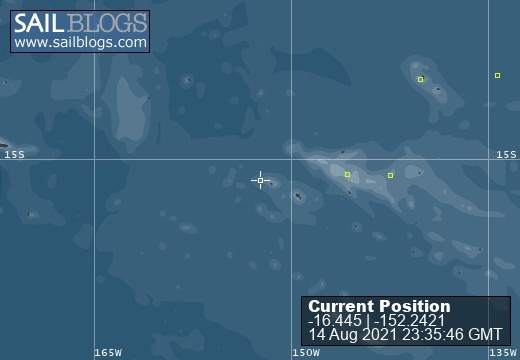
14 August 2021
12 June 2021
02 May 2021
21 February 2021 | Toau Atoll
29 January 2021
16 January 2021
17 December 2020
09 February 2020
09 February 2020
28 January 2020
18 June 2019
23 January 2019 | Rotoava
06 January 2019 | Fakarava
17 November 2018
28 October 2018
14 October 2018 | Papeete, Tahiti
19 August 2018 | 16 06.30'S:142 22.78'W, Rarioa, French Polynesia
30 July 2018 | 16 06.30'S:142 22.78'W, Nuku Hiva
Panama to French Poly At Sea - day 23
16 April 2018 | 07 18.45'S:120 44.3'W, ~1100 nm east of Nuku Hiva
Bob
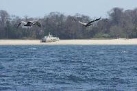
Monday April 16, 2018 Day 23 at sea We feel like we are getting close, only about 1100 miles to go! Or about a week. The photo of the Pelicans was taken as we entered the Les Pearlas Islands that Shawnda took on our way in there 3 weeks ago. I just found it on one of the cameras.
We had a couple of squally nights lately but nothing too bad. We are averaging around 7 kts. Yesterday we did 171 miles, much better than 88 miles north of the Galapagos! The wind is supposed to get milder over the next few days, down to around 15 kts or less. Should still be okay though. As we have said previously, we are not pushing the boat at all. Double reef in the genoa the last few nights (squalls around) with the Solent out as well on the opposite side. Have not used the main sail in about a week.
A SPECIAL thanks goes out to Sheldon, Payton and Atari! I asked them to help me with some questions I had about French Polynesia as we don�'t have �"real�" internet out here. More about that later�.... So, from their emails: Sheldon, we are heading to an Island called Nuku Hiva in French Polynesia. Can you find out for me, How many Islands there are in ALL of French Polynesia?
hi papa its Sheldon i have the answer the answer is 118 islands split into five groups the five groups are called society tuamotu marquesas australs gambiers are the group names
Payton, I think French Polynesia is a big place but am not sure just how big. Can you find out how many square kilometers (or miles) is all of French Polynesia? Hi papa I know the answer it's 3521 square kilometers(1360) And; Atari; Can Mom help you find out how high the mountain is in Nuku Hiva? Hey Papa Nana, its Atari.. the highest peak/mountain in Nuku Hiva would be the Tekao. It has an elevation of 1,224 m. and is located in the province of Te l'i.
So thank you Sheldon, Payton and Atari! This place is WAY BIGGER than I thought it was!
So the internet on the boat is extremely slow. We have an Iridium Go (nicked name Iridium Slow by everyone who has one) but it is sufficient to do weather checking, basic emails and texting too! We have the �"unlimited data�" plan that comes with 150 minutes of voice calling too! Sounds too good to be true? Well, first, we cannot seem to get the calling working, I think that is because of the antenna moving around as the boat rocks. We will try at anchor later. The Iridium Go has a slow data speed; about 2.4 kb. Your old home �"dial up�" was around 16 kb or about 8 times faster! So we do have the �"unlimited data plan�" at the moment. It is Unlimited but a good analogy would be; Your local bar special offered �"unlimited beer per month�" at a fixed rate but the catch is, you can only drink it through a syringe! So, we are checking weather which I do twice daily using a Program called �"Predict Wind�". Predict Wind can be optimized for slow satellite internet. I select the data that I want, the area that I want to view etc. and then click download. I then go for supper or ??? Depending what I have requested it usually takes over 30 minutes to download. The download is always less than a MB so that should give you an idea how slow it is. The nice thing is though, if it �"drops the connection�" (it does several times through a download) it restarts itself and continues where is left off, not at the beginning! That is nice. It does take some getting used to though as we are all accustom to information NOW! Predict Wind gives me several options to choose from. I set my proposed route and off it goes to New Zealand where their servers look at the route, takes into account our boat�'s performance parameters, preferences (avoid wind over 35 kts for example) and so on, then the wind from 4 different sources (GFS, Euro and 2 Predict Wind models), currents etc. and then sends back 4 different routes based on that information. It is then up to me to pick the route I want or split the difference. Which model do I prefer? I don�'t know. My experience is the Euro model has always appeared more accurate in the last few years in the Caribbean but the GFS computer model was improved last year. I only just started using Predict Wind on this trip thanks to Paul on Scally Wag that we met last year in Bonaire. Paul is a Kiwi and should be back there by now. Looking out the window and seeing what is really happening vs. the computer models is interesting and not exact. So I look at them all. They are all usually pretty close to each other though.
Comments
| Vessel Name: | Hedonism |
| Vessel Make/Model: | Outbound '46 |
| Hailing Port: | Thunder Bay, Ontario |
| Crew: | Bob and Laurie Mackie |
| About: | Retired |
| Extra: | |
| Home Page: | http://hedonism1.ca/ |
Hedonism's Photos - Main
No items in this gallery.
Hedonism
Who: Bob and Laurie Mackie
Port: Thunder Bay, Ontario