Hedonism
10 April 2022
12 September 2021 | Maupiti
14 August 2021
12 June 2021
02 May 2021
21 February 2021 | Toau Atoll
29 January 2021
16 January 2021
17 December 2020
09 February 2020
09 February 2020
28 January 2020
18 June 2019
23 January 2019 | Rotoava
06 January 2019 | Fakarava
17 November 2018
28 October 2018
14 October 2018 | Papeete, Tahiti
19 August 2018 | 16 06.30'S:142 22.78'W, Rarioa, French Polynesia
30 July 2018 | 16 06.30'S:142 22.78'W, Nuku Hiva
Moving on to Raroia Atoll, Tuamotu Archipelago, French Polynesia
30 July 2018 | 16 06.30'S:142 22.78'W, Nuku Hiva
Bob
July 30, 2018
Moving on to Raroia Atoll, Tuamotu Archipelago, French Polynesia
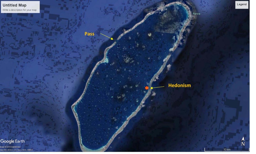
After almost 3 months in the Marquesas it was time to move on. So we provisioned for the estimated 2 or 3 months without any supplies for our visits to the more remote Atolls of French Polynesia. BTW; French Polynesia is about the same size as ALL of continental Europe, so lots of destinations. I did not realize just how big it is. You could spend a lot of time here and not visit the same place twice. (It is a 3 ½ hour flight from Nuku Hiva to Tahiti for example on an ATR 42) We departed Nuku Hiva at 4 PM local time for the estimated 2 ½ day or 450 NM sail to Raroia. As usual in Taiohae Bay, we had a stern anchor set to point the bow into the continuous swell coming in the bay to keep from rolling. From what I could see, there were perhaps 4 boats with stern anchors out and the rest to them rolled side to side constantly, sometimes toe rail to toe rail. (and then complain about their lack of sleep and how rolly the anchorage was) Sorry, I digressed. Taking up the stern anchor involved letting out our bow anchor rode and winching ourselves over the stern anchor to winch it up. It was so �"set�" there was no way to pull it out by hand. (I tried to pull it out with the dinghy there once and it would not budge at full power) So, just as we break the anchor loose from the bottom a squall came over the hill and hit us with 25 kt winds and a torrential downpour. We just sat and waited it out. Once we got everything up and stored for the sail we sailed out of the bay getting hit by one squall after another until we were about 10 miles south of the island. Not a pleasant way to leave but oh well. The sail itself was fairly uneventful. New rule on the boat though; Boobies are not allowed to roost on the boat at night. Too much work the next day�..... (Boobies overgrown Seagulls) We did not know it until the next morning but one had landed on the solar panels and spent the night. We knew about the one on the dinghy. Had to get the salt water hose out the next morning. The wind was fairly constant but on the last night I noticed a squall rapidly forming about 5 miles upwind from us. They do form rapidly, perhaps in 20 minutes, pretty amazing. So we ended up putting in a double reef and less than a minute later we were in it, 35 kts of wind but no rain. The rain passed both ahead and behind us. We actually needed the rinse cycle�.... We did get up to over 10 kts in the squall though. Stepping back a bit, we planned our departure timing so that we would arrive at Raroia close to slack tide with the sun high in the sky and NO (or very few) clouds. That was the hard part but you cannot navigate in the Lagoon without sunshine overhead. No maps here, too many coral heads coming straight up to the surface from 100+ feet down. See the attached photo, those white blobs in the lagoon are the larger coral heads. You can�'t see the small ones in the Google Earth shot. As we approached the Atoll we had a nice sunny morning and arrived ahead of our planned arrival time, by a few hours. There was �"supposed�" to be a slack tide at around 7:30 am so we could sneak in the only pass in the reef into the lagoon. To figure out �"slack tide times�" someone has made a tide �"Guesstimator�", basically a calculator that took the tides from one tide station a couple hundred miles away and based Low, High and Slack tide times as well as currents in the passes. Everyone cruising here has a copy of the program. Anyhow, we arrived about 30 minutes prior to the �"guesstimated�" slack time and realized that the slack tide had already passed and the water was roaring out of the lagoon due to the tide ebbing. We were not completely disappointed as it was early so the sun was low and in our face; not the �"high in the sky�" sun we really needed to cross inside of the lagoon. While some boats may have powered in anyways we elected to wait it out for the next slack tide. The current in the pass was 4+ knots but the water throughout looked like we were going to shoot rapids, uphill! And, this was our first experience doing a �"pass�" into a lagoon. So we turned the boat around and put out the Solent only and sailed back towards the Marquesas direction for a couple hours. We then turned around to arrive back at the pass at least 1 ½ hours prior to the slack time as spit out by the �"Guesstimator�" to be sure to get the slack tide. It was already going full force INTO the lagoon when we got there. So much for the Guesstimator�... Well, it was now about noon local time, the sun was high so we decided to shoot the pass anyways �- downhill though. So we went from thousands of feet of water to less than 20 in nothing flat. The Atoll comes straight up from the ocean bottom. Fortunately there was a �"range�" (Localizer approach) in the lagoon to line up with to keep us centered in the pass. In places it was only 2 feet deep off to our starboard �- a good reason to stay on course. But with the current all over the place it was like shooting an instrument approach with wind shears every hundred feet. 30 degrees right of course to m ake COG and then 20 left, back and forth. Oh, did I mention bouncy? IFR skills helped�... We entered at high power to maintain steerage in the 4 + kt tail wind, I mean current. I asked Laurie later what our SOG was in the pass (Speed over Ground) and neither of us knew, we were both to busy navigating the pass to look. Once just inside the pass you have to make a 90 degree turn to the right to avoid coral �"Bommies�", all while still in the current. That was fun but very quickly after we got away from the current and things settled down. As we headed in along the west coast of the lagoon we could see the village (population ~60) and the Pearl Farm buoys �- everywhere! There are boat catching nets associated with those! Not to mention unhappy Pearl Farmers if you rip up their nets (fences really). So, our destination was the east side of the lagoon to get shelter from the east trade winds, 6 ½ miles away, we turned left to head over. Now we had first chance at �"eyeball navigation�" (not really, been doing it since I as a kid). But just like home, sun high in the sky and preferably a bit on your back makes it easier to see the �"Bommies�" as well as the buoys of the Pearl Farms. While most are fairly easy to see there were a couple that were dark brown and small that we did not see until a couple of hundred of feet away. Those ones would have been a problem if the sun was not out. Before we crossed the lagoon we started a �"track�" on the chart plotter so we could use the reverse track to get out in not-so-good light conditions if need be. We were sure to set it to the most accurate setting updating every 0.01 nm instead of the normal .1 nm. Yes, we were �"weaving�" that much. So here we are. We only saw one other sail boat anchored about 2 miles up from us. They actually moved down and anchored adjacent to us to get more protection the wind which is now backing a bit north of east. Speaking with them, they have been here since March! And in French Polynesia since last March (2017). They spent the cyclone season in Anaho Bay on Nuku Hiva and are planning the same this year too. Funny, we were thinking the same thing. So we are now settled in, have sunshine all day long most days (no mountains around) and wind. In the Marquesas we had to run the generator once daily as it was so cloudy and shaded with the mountains. Here, we are making water and running everything on solar and wind. Nice to get back to that. Did I mention sharks? EVERYWHERE! Some get right up and close. Many hang out in the small �"passes�" (only a foot deep or so) between the islets (I think they are call Motu�'s) along the edge of the lagoon. There, the water flows into the lagoon from the sea and the sharks are waiting for snacks to arrive? So every time we go out and walk the shore we see 10 or more sharks, not all babies! Black tip reef sharks, lemon sharks, black(er) sharks (type unknown to me) and whiter ones as well. So, that takes some mind bending to get used to. I do swim around the boat and I need to dive and clean the bottom hull. We do see the sharks swimming around the boat on a daily basis. I guess I have to remember that the Pearl Farmers spend their entire day in the water and the population is �"steady�" at 60. Oh; and that tide Guesstimator�"? The day after we anchored I sat down to see why it was so far �"off�". The Guesstimator bases its calculations on the Tide Tables for another Atoll about 300 nm west of here. Those tables are listed in the Guesstimator. I had also downloaded the NOAA tide tables to my computer before we left Nuku Hiva and Elaine emailed the tide tables for the only other station in the Tuamotus, Hao Atoll which is also a couple of hundred miles away (SE). (Thanks Elaine!!!!) Long story short, the tables are published in GMT (UTC) and who ever entered them into the Guesstimator converted them to �"Local time�" here which is supposed to be -10 hours GMT. The problem is; they entered them into the calculator using -11 Hours GMT! I had read that a couple of people were complaining that the Guesstimator was off but no one that I know of realizes that the Reference Tide tables are off by exactly one hour, every day. One last thing, no WIFI here so I will not be able to update the photo album for a while.
Moving on to Raroia Atoll, Tuamotu Archipelago, French Polynesia
After almost 3 months in the Marquesas it was time to move on. So we provisioned for the estimated 2 or 3 months without any supplies for our visits to the more remote Atolls of French Polynesia. BTW; French Polynesia is about the same size as ALL of continental Europe, so lots of destinations. I did not realize just how big it is. You could spend a lot of time here and not visit the same place twice. (It is a 3 ½ hour flight from Nuku Hiva to Tahiti for example on an ATR 42) We departed Nuku Hiva at 4 PM local time for the estimated 2 ½ day or 450 NM sail to Raroia. As usual in Taiohae Bay, we had a stern anchor set to point the bow into the continuous swell coming in the bay to keep from rolling. From what I could see, there were perhaps 4 boats with stern anchors out and the rest to them rolled side to side constantly, sometimes toe rail to toe rail. (and then complain about their lack of sleep and how rolly the anchorage was) Sorry, I digressed. Taking up the stern anchor involved letting out our bow anchor rode and winching ourselves over the stern anchor to winch it up. It was so �"set�" there was no way to pull it out by hand. (I tried to pull it out with the dinghy there once and it would not budge at full power) So, just as we break the anchor loose from the bottom a squall came over the hill and hit us with 25 kt winds and a torrential downpour. We just sat and waited it out. Once we got everything up and stored for the sail we sailed out of the bay getting hit by one squall after another until we were about 10 miles south of the island. Not a pleasant way to leave but oh well. The sail itself was fairly uneventful. New rule on the boat though; Boobies are not allowed to roost on the boat at night. Too much work the next day�..... (Boobies overgrown Seagulls) We did not know it until the next morning but one had landed on the solar panels and spent the night. We knew about the one on the dinghy. Had to get the salt water hose out the next morning. The wind was fairly constant but on the last night I noticed a squall rapidly forming about 5 miles upwind from us. They do form rapidly, perhaps in 20 minutes, pretty amazing. So we ended up putting in a double reef and less than a minute later we were in it, 35 kts of wind but no rain. The rain passed both ahead and behind us. We actually needed the rinse cycle�.... We did get up to over 10 kts in the squall though. Stepping back a bit, we planned our departure timing so that we would arrive at Raroia close to slack tide with the sun high in the sky and NO (or very few) clouds. That was the hard part but you cannot navigate in the Lagoon without sunshine overhead. No maps here, too many coral heads coming straight up to the surface from 100+ feet down. See the attached photo, those white blobs in the lagoon are the larger coral heads. You can�'t see the small ones in the Google Earth shot. As we approached the Atoll we had a nice sunny morning and arrived ahead of our planned arrival time, by a few hours. There was �"supposed�" to be a slack tide at around 7:30 am so we could sneak in the only pass in the reef into the lagoon. To figure out �"slack tide times�" someone has made a tide �"Guesstimator�", basically a calculator that took the tides from one tide station a couple hundred miles away and based Low, High and Slack tide times as well as currents in the passes. Everyone cruising here has a copy of the program. Anyhow, we arrived about 30 minutes prior to the �"guesstimated�" slack time and realized that the slack tide had already passed and the water was roaring out of the lagoon due to the tide ebbing. We were not completely disappointed as it was early so the sun was low and in our face; not the �"high in the sky�" sun we really needed to cross inside of the lagoon. While some boats may have powered in anyways we elected to wait it out for the next slack tide. The current in the pass was 4+ knots but the water throughout looked like we were going to shoot rapids, uphill! And, this was our first experience doing a �"pass�" into a lagoon. So we turned the boat around and put out the Solent only and sailed back towards the Marquesas direction for a couple hours. We then turned around to arrive back at the pass at least 1 ½ hours prior to the slack time as spit out by the �"Guesstimator�" to be sure to get the slack tide. It was already going full force INTO the lagoon when we got there. So much for the Guesstimator�... Well, it was now about noon local time, the sun was high so we decided to shoot the pass anyways �- downhill though. So we went from thousands of feet of water to less than 20 in nothing flat. The Atoll comes straight up from the ocean bottom. Fortunately there was a �"range�" (Localizer approach) in the lagoon to line up with to keep us centered in the pass. In places it was only 2 feet deep off to our starboard �- a good reason to stay on course. But with the current all over the place it was like shooting an instrument approach with wind shears every hundred feet. 30 degrees right of course to m ake COG and then 20 left, back and forth. Oh, did I mention bouncy? IFR skills helped�... We entered at high power to maintain steerage in the 4 + kt tail wind, I mean current. I asked Laurie later what our SOG was in the pass (Speed over Ground) and neither of us knew, we were both to busy navigating the pass to look. Once just inside the pass you have to make a 90 degree turn to the right to avoid coral �"Bommies�", all while still in the current. That was fun but very quickly after we got away from the current and things settled down. As we headed in along the west coast of the lagoon we could see the village (population ~60) and the Pearl Farm buoys �- everywhere! There are boat catching nets associated with those! Not to mention unhappy Pearl Farmers if you rip up their nets (fences really). So, our destination was the east side of the lagoon to get shelter from the east trade winds, 6 ½ miles away, we turned left to head over. Now we had first chance at �"eyeball navigation�" (not really, been doing it since I as a kid). But just like home, sun high in the sky and preferably a bit on your back makes it easier to see the �"Bommies�" as well as the buoys of the Pearl Farms. While most are fairly easy to see there were a couple that were dark brown and small that we did not see until a couple of hundred of feet away. Those ones would have been a problem if the sun was not out. Before we crossed the lagoon we started a �"track�" on the chart plotter so we could use the reverse track to get out in not-so-good light conditions if need be. We were sure to set it to the most accurate setting updating every 0.01 nm instead of the normal .1 nm. Yes, we were �"weaving�" that much. So here we are. We only saw one other sail boat anchored about 2 miles up from us. They actually moved down and anchored adjacent to us to get more protection the wind which is now backing a bit north of east. Speaking with them, they have been here since March! And in French Polynesia since last March (2017). They spent the cyclone season in Anaho Bay on Nuku Hiva and are planning the same this year too. Funny, we were thinking the same thing. So we are now settled in, have sunshine all day long most days (no mountains around) and wind. In the Marquesas we had to run the generator once daily as it was so cloudy and shaded with the mountains. Here, we are making water and running everything on solar and wind. Nice to get back to that. Did I mention sharks? EVERYWHERE! Some get right up and close. Many hang out in the small �"passes�" (only a foot deep or so) between the islets (I think they are call Motu�'s) along the edge of the lagoon. There, the water flows into the lagoon from the sea and the sharks are waiting for snacks to arrive? So every time we go out and walk the shore we see 10 or more sharks, not all babies! Black tip reef sharks, lemon sharks, black(er) sharks (type unknown to me) and whiter ones as well. So, that takes some mind bending to get used to. I do swim around the boat and I need to dive and clean the bottom hull. We do see the sharks swimming around the boat on a daily basis. I guess I have to remember that the Pearl Farmers spend their entire day in the water and the population is �"steady�" at 60. Oh; and that tide Guesstimator�"? The day after we anchored I sat down to see why it was so far �"off�". The Guesstimator bases its calculations on the Tide Tables for another Atoll about 300 nm west of here. Those tables are listed in the Guesstimator. I had also downloaded the NOAA tide tables to my computer before we left Nuku Hiva and Elaine emailed the tide tables for the only other station in the Tuamotus, Hao Atoll which is also a couple of hundred miles away (SE). (Thanks Elaine!!!!) Long story short, the tables are published in GMT (UTC) and who ever entered them into the Guesstimator converted them to �"Local time�" here which is supposed to be -10 hours GMT. The problem is; they entered them into the calculator using -11 Hours GMT! I had read that a couple of people were complaining that the Guesstimator was off but no one that I know of realizes that the Reference Tide tables are off by exactly one hour, every day. One last thing, no WIFI here so I will not be able to update the photo album for a while.
Comments
| Vessel Name: | Hedonism |
| Vessel Make/Model: | Outbound '46 |
| Hailing Port: | Thunder Bay, Ontario |
| Crew: | Bob and Laurie Mackie |
| About: | Retired |
| Extra: | |
| Home Page: | http://hedonism1.ca/ |
Hedonism's Photos - Main
No items in this gallery.
Hedonism
Who: Bob and Laurie Mackie
Port: Thunder Bay, Ontario