21 March 2014 | 53 54.7'S:067 45.9'W, Beagle Channel
05 March 2014 | 64 49.7'S:063 29.6'W, Lockroy
04 March 2014 | 64 49.7'S:063 29.6'W, Lockroy
03 March 2014 | 65 06.5'S:064 04.4'W, Pleneau
28 February 2014 | 65 03.9'S:064 01.9'W, Port Charcot
23 February 2014 | 64 49.5'S:063 29.6'W, Port Lockroy
22 February 2014 | 64 49.5'S:063 29.6'W, Port Lockroy
20 February 2014 | 64 49.5'S:063 29.6'W, Port Lockroy
20 February 2014 | 64 49.5'S:063 29.6'W, Port Lockroy
14 February 2014 | 64 49.5'S:063 29.3'W, Port Lockroy
12 January 2014 | 64 49.2'S:063 29'W, Port Lockroy
27 December 2013 | 64 49.2'S:063 29'W, Port Lockroy
23 December 2013 | 64 49.2'S:063 29'W, Port Lockroy
20 December 2013 | 64 49.2'S:063 29'W, Port Lockroy
26 November 2013 | 60 15.9'S:065 54.7'W, Drake Passage
23 November 2013 | 64 49.7'S:063 29.6'W, Jougla Point, Port Lockroy
16 November 2013 | 64 49.7'S:063 29.6'W, Jougla Point, Port Lockroy
13 November 2013 | 64 49.4'S:063 29.7'W, In the fast ice, back bay Port Lockroy
11 November 2013 | 64 49.7'S:063 29.8'W, Half a mile from Port Lockroy
07 November 2013 | 64 49.7'S:063 29.8'W, Half a mile from Port Lockroy
Deception calling
29 November 2011 | Inner Telefon Bay, Deception Island
Magnus Day
Yesterday morning about 10:30 local I was on deck watching the world go by. Sailing is all about watching. 12 hours a day are spent watching. I often wonder what exactly I'm supposed to be watching as a whole watch can go by with absolutely no change to the conditions and no passing ships, especially in this part of the world. Any road there I was watching in a forward direction as it happens and it occured to me that the clouds some way above the horizon were not behaving quite right. The looked sort of, well solid. I grabbed the Rommels (binoculars) for a closer look and sure enough I was looking at a mountain peak. A check of the chart showed this was most likely the northern peak of Smith Island almost 60 miles away! As the sky cleared a little more and the ridge of the island and the much taller southern peak appeared I called Thomas on deck to verify my amazing discovery. I pointed, Thomas looked and accused me of being simple. 'No no right up there' I told him. 'Where?', 'Right up there', 'Jeez, that is high!' exclaimed Thomas.
Smith Island is on our chart at 6900 feet at it's higher southern peak, over 2100m tall and less than 5 miles wide. A veritable fin of rock rising out of the sea.
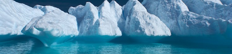
The light on the Antarctic Penninsula is something to behold but generally it seems to follow one of two themes. There is the stunning blue sky and black rock and white ice theme and there is the thousands of shades of grey theme. Yesterday afternoon was definately the thousands of shades of grey theme with a heavy leaden sky hanging somewhere above mast height and a dullness and yet infinite detail to everything. The air was somehow transparent in a visible kind of way and we encountered our first icebergs of the trip. In this moody atmosphere we sailed in on a close reach under full sail over smooth seas. A very fitting end to a smooth, one tack passage that has had the wind just off the starboard bow almost all the way from Stanley.
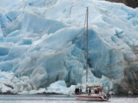
As I mentioned before in this blog it seems to take a long time to leave any port but it seems to take even longer to get into the next one, a sensation heightened by the good visibility. Slowly Deception hove into view, its coastal rocks first and then it's flanks and finally the peaks of its many craters revealed themselves. Cruising down the west and south coasts of the island the enormity of the tasks set us by Ron Naveen and his Oceanites organisation became apparent. We had Thomas' computer on deck with a beautiful satellite image of Deception with the penguin colonies he wants to survey marked on it. It seems that one of the reasons that Chinstrap penguins survive is their ability to colonise nasty, inhospitable, inaccesible unfriendly patches of rock in the middle of nowhere. We have to visit and count all the penguins therein. This is not going to be easy. If we can read car number plates from space can we not count penguins? Luckily for us it seems we cannot. Yet.
The entrance to lagon that forms the centre of Deception (Port Foster) is called Neptune's Bellows and is about one third of a mile across and only 20 meters deep with a rock in the middle which caught out a cruise ship just a few years ago. It's quite a dramatic way into anywhere with high cliffs on either side and view into the snowy bowl beyond. We've all been here before but even in the halflight of the midnight dusk things did not look quite right. The snow of the mountain sides continued across the fives miles of water in the lagoon. Ice! And loads of it! Passing Whalers Bay on our right it was by no means clear that we would be able to find our way all the way across Port Foster to Telephon Bay. A quick scan from the spreaders confirmed our fears, 60-70% ice all the way across, only first year sea ice and fairly broken but still about a meter thick and with no clear leads all the way across and Pelagic is no ice breaker. With a forty knot blow forecast for two days time and no other really secure anchorages nearby Telephon it had to be and we decided to try. In the end we got across with yours truly sat on the spreaders halfway up the mast directing and some expert driving from Chris Harris. It took a couple of hours, an extremely cold backside for me and a bit of ice shunting to cross the lagoon in the grey light. Often I was giving directions when I wasn't really sure if I was taking us into an ice cul de sac.
The last mile or so was much clearer so arrived at Telephon in high spirits only to have them dashed as we rounded the head to discover the entrance completely blocked with ice. Soft thin watery looking ice but all the way across the entrance and perhaps 50 meters across. This area is not really charted and the homemade charts we have in the Pelagic 'rutter' only plot the depths if you drive in through the middle of the channel, just where the ice looked thickest and widest. Backing outside we anchored temporerily to assemble the 'Zode' and went for a look withhand held depth finder and hunting rangefinder in hand. More bad luck, the depthfinder had given up the ghost, reliably informing us the water was about zero but giving no clue as to the depth. Back to the old skool, a knotted string with a weight on the end. Yes we would give it go.
It took a few goes to butt our way through but 35 tonnes of steel with a pointy front end goes along way to detering mushy ice which eventually tore away from the shore on one side and swung aside like a half acre door and let us in. We puttered into Telephon Bay outer and with a bit more survey work into Telephon inner, a tiny bay seemingly well sheltered from the west where we expect the worst winds from in the coming days.
Chris and I have both worked in this environment quite a lot but we've never anchored a boat together and this is not an easy anchorage. The holding is lightweight volcanic gravel, kind of like mooring in a bowl of granola and there a but a few sustantial rocks to tie extra mooring lines to and they manage to all to in the wrong place. It took a while to sort it out but eventually Pelagic was lying to one anchor and three lines and we were all below enjoying well earned bacon and eggs. It was 7:30 in the morning......
Smith Island is on our chart at 6900 feet at it's higher southern peak, over 2100m tall and less than 5 miles wide. A veritable fin of rock rising out of the sea.
The light on the Antarctic Penninsula is something to behold but generally it seems to follow one of two themes. There is the stunning blue sky and black rock and white ice theme and there is the thousands of shades of grey theme. Yesterday afternoon was definately the thousands of shades of grey theme with a heavy leaden sky hanging somewhere above mast height and a dullness and yet infinite detail to everything. The air was somehow transparent in a visible kind of way and we encountered our first icebergs of the trip. In this moody atmosphere we sailed in on a close reach under full sail over smooth seas. A very fitting end to a smooth, one tack passage that has had the wind just off the starboard bow almost all the way from Stanley.
As I mentioned before in this blog it seems to take a long time to leave any port but it seems to take even longer to get into the next one, a sensation heightened by the good visibility. Slowly Deception hove into view, its coastal rocks first and then it's flanks and finally the peaks of its many craters revealed themselves. Cruising down the west and south coasts of the island the enormity of the tasks set us by Ron Naveen and his Oceanites organisation became apparent. We had Thomas' computer on deck with a beautiful satellite image of Deception with the penguin colonies he wants to survey marked on it. It seems that one of the reasons that Chinstrap penguins survive is their ability to colonise nasty, inhospitable, inaccesible unfriendly patches of rock in the middle of nowhere. We have to visit and count all the penguins therein. This is not going to be easy. If we can read car number plates from space can we not count penguins? Luckily for us it seems we cannot. Yet.
The entrance to lagon that forms the centre of Deception (Port Foster) is called Neptune's Bellows and is about one third of a mile across and only 20 meters deep with a rock in the middle which caught out a cruise ship just a few years ago. It's quite a dramatic way into anywhere with high cliffs on either side and view into the snowy bowl beyond. We've all been here before but even in the halflight of the midnight dusk things did not look quite right. The snow of the mountain sides continued across the fives miles of water in the lagoon. Ice! And loads of it! Passing Whalers Bay on our right it was by no means clear that we would be able to find our way all the way across Port Foster to Telephon Bay. A quick scan from the spreaders confirmed our fears, 60-70% ice all the way across, only first year sea ice and fairly broken but still about a meter thick and with no clear leads all the way across and Pelagic is no ice breaker. With a forty knot blow forecast for two days time and no other really secure anchorages nearby Telephon it had to be and we decided to try. In the end we got across with yours truly sat on the spreaders halfway up the mast directing and some expert driving from Chris Harris. It took a couple of hours, an extremely cold backside for me and a bit of ice shunting to cross the lagoon in the grey light. Often I was giving directions when I wasn't really sure if I was taking us into an ice cul de sac.
The last mile or so was much clearer so arrived at Telephon in high spirits only to have them dashed as we rounded the head to discover the entrance completely blocked with ice. Soft thin watery looking ice but all the way across the entrance and perhaps 50 meters across. This area is not really charted and the homemade charts we have in the Pelagic 'rutter' only plot the depths if you drive in through the middle of the channel, just where the ice looked thickest and widest. Backing outside we anchored temporerily to assemble the 'Zode' and went for a look withhand held depth finder and hunting rangefinder in hand. More bad luck, the depthfinder had given up the ghost, reliably informing us the water was about zero but giving no clue as to the depth. Back to the old skool, a knotted string with a weight on the end. Yes we would give it go.
It took a few goes to butt our way through but 35 tonnes of steel with a pointy front end goes along way to detering mushy ice which eventually tore away from the shore on one side and swung aside like a half acre door and let us in. We puttered into Telephon Bay outer and with a bit more survey work into Telephon inner, a tiny bay seemingly well sheltered from the west where we expect the worst winds from in the coming days.
Chris and I have both worked in this environment quite a lot but we've never anchored a boat together and this is not an easy anchorage. The holding is lightweight volcanic gravel, kind of like mooring in a bowl of granola and there a but a few sustantial rocks to tie extra mooring lines to and they manage to all to in the wrong place. It took a while to sort it out but eventually Pelagic was lying to one anchor and three lines and we were all below enjoying well earned bacon and eggs. It was 7:30 in the morning......
Comments
| Vessel Name: | Pelagic |
| Hailing Port: | Stanley, Falkland Islands |
Gallery not available
Port: Stanley, Falkland Islands