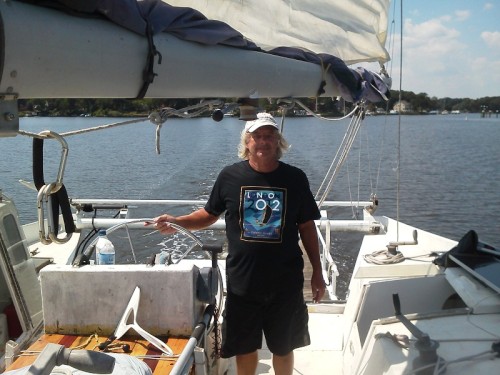
Kaimusailing
s/v Kaimu Wharram Catamaran
| Vessel Name: | Kaimu |
| Vessel Make/Model: | Wharram Custom |
| Hailing Port: | Norwalk, CT |
| Crew: | Andy and the Kaimu Crew |
| About: | Sailors in the Baltimore, Annapolis, DC area. |
17 April 2024 | St Marys, GA
Dinghy Skeg
I was suffering with what seemed like a cold and also had allergy symptoms. I awoke and felt fine. The green pollen that was coating everything was gone. Maybe it will return.
07 April 2024 | St. Marys, GA
Clammy Hands
Items came in from TEMU, the Chinese cut rate retailer. One was a nice little drone that cost about twelve and a half dollars. It looked like an easy thing to play with while I coughed and sneezed. I was fighting a summer cold, even though it is not summer elsewhere, it seems like it here. A nice [...]

02 April 2024 | St. Marys, GA
Sun Doggie
After laminating the cedar strips onto the gunwales of the dinghy I found the screws I used wouldn’t come out. The epoxy had seized them. The screw heads were stripped so I cut a straight slot in the heads with the cut off wheel. The cedar smoked when the screw heads got red hot. I could remove [...]
21 March 2024 | St. Marys, GA
Just Add Water
The rainy weekend started off with overcast and fog but no rain. It looked like I might be able to get something done on the D4 dinghy. I wanted to change the bow seat which is really the bow deck. The sailing option uses the deck to hold the freestanding mast. I didn’t like how the deck looked, [...]
01 March 2024 | St. Marys, GA
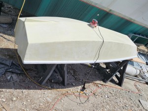
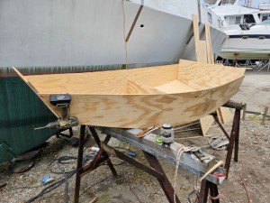
D4 Dinghy Alternative Seats
The rain event was more wind than rain, strong winds with gusts up to 44 mph. We drove into town to see what the harbor was like. There was a small sailboat that had dragged anchor and was sitting close to shore. The tide was out. We left and played with Bleu at Notter’s Pond.
23 February 2024 | St. Marys, GA
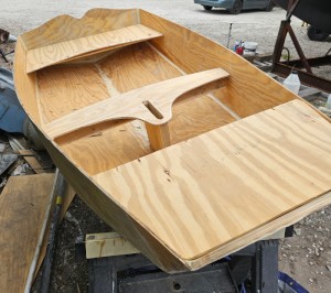
D4 Inside Seams
Day two of the dinghy build started out with me finishing wiring the hull bottoms together on the centerline of the bottom panels. This was much easier than the wiring of the chine edges of the bottom panels and the side panels.
Willoughby Bay to Bodkin Inlet
.
We will have to make a new #4 beam and that would be best be done back at the boatyard at St. Marys. I have some rigging adjustment to do and some sail repair. That will be done in the Annapolis area. The D4 dinghy needs its bow repaired, plus I would like to make another version of it and sell the original. It’s a nice little boat but has too little leg room for me.
.
I don’t want to get into the condition where the boat is deteriorating faster than I can keep up with it. Sooner or later I will need help, including help with sailing her, but the ethos now is DIY and write about it, maybe it will save some other soul from getting caught up in a never ending project. I’m not sure it’s this boat or me, or maybe everyone has a list of things to do and never enough time to do it all. The fact that we have made it up to the Bay indicates we are operational and functional.
.
In the morning I went about my business knowing it was late, 8 AM breakfast, underway at 10 with a real struggle to get that anchor up. Lots of radio traffic, Navy ships returning from wherever they went to hide from the hurricane. Two vessels in particular announced safety clearance of 500 yards and do not cross our bows. It was an aircraft carrier and a submarine. I was hugging the South side of the channel and not in it, so if they wanted to run me down, they couldn’t, I was in too shallow water.
.
I decided to get to the other side of the channel, since I was going North and there seemed to be a lull in the marine traffic. I set my sights on the red buoy across the channel and revved up the engine, I wanted to get across before any more ships came through. The submarine has almost no profile when it is on the surface, just the conning tower and the hull is very low to the water. There was a patrol boat associated with the sub and I could see that I would barely make it across. But I did.
.
I was working my way NE and the wind was from the SE, on the beam. We had to keep heading NE to clear the western shore of the bay and the various points and shoals. We could turn North at The Wolf Trap. Our speed increased to 7 knots, the forecast was for 15-20 SE and S during the overnight. I decided to take advantage of these positive conditions and go all night. If I got tired and had to stop we would at least gain a lot of ground with the wind on our tail. We had enough fuel to go all the way.
.
The other consideration was that a North wind was forecast following these South breezes. Going North against the wind whether sailing or motoring would be no fun. If we at least got the bulk of the trip up the bay done in benign conditions, then any difficulties would be kept to a minimum.
.
The tailwind had us putting down a steady 6-7 knots under power and buoys came by one after the other. We would hit the halfway point after dark when we passed Smith Point. Smith Point is where the Potomac River enters the bay, it is the South shore of the river. The Potomac is very wide at the bay and it takes a long time to put it behind us.
.
The wind begins to drop off in the wee hours of the morning and I finally decide to get some rest. When I stop the engine the boat is dead still in the water. I don’t deploy the anchor but keep the anchor light on. We are in about 10 feet of water with a long way to drift to the North. We have passed Cove Point. I only sleep for about 40 minutes, then start the engine briefly to keep it warm. I make breakfast of coffee and leftover tuna salad sandwich. I decide to get underway and turn the key to start the engine but nothing happens. I check to make sure it is in neutral, still no action. This has happened before when the fuse at the engine vibrated apart. I contemplate trying to work on the engine in the dark with the wave action. Not likely.
.
I manage to get the boat headed in the right direction making about 1 1/2 knots. After a long while I try to start the engine again and it starts. We are underway again. I am now hugging the right side of the channel which is more straightforward than all the inlets and towns on the West shore of the bay.
.
I am calculating how much fuel we have used, how far we have gone, how far left to go, and I realize we are cutting it close. We’ve put in about 2/3‘s of the distance, about a hundred miles, and have used 26 gallons of fuel. We started with 38, so the remaining 12 gallons of fuel would just about get us to Bodkin Inlet, our destination. However, we had great assistance of the following 15-20 breeze and now would not have that. We will probably burn fuel at a greater rate without the wind aiding us.
.
I have marginal phone service out on the bay but I am able to search for “fuel dock Kent Island”. We will pass close to Kent Island which is across the bay from Annapolis. The best bet there looks to be Bay Bridge Marina. It does take us a while to get there, now going 4 1/2 knots. I begin to feel tired but I keep at it. I am navigating from red buoy to red buoy and the magnetic course of 020 lines up a bunch of these buoys in a row. I have a section of 9 miles that will take 2 hours, of course, and I can watch the fuel gauge to see how much fuel we burn in those 2 hours. It turns out we are just under 1 1/2 gallons per hour, which is what this engine has done in the past.
.
When I get within 10 miles of the marina I call their number to find out if I can squeeze a 44 foot catamaran with a 22 foot beam into their fuel dock. Shockingly, they reply that their fuel dock is closed and has been all summer. I panic. I have about 3 gallons of fuel left and a range of about 10 miles. Then I remember the little day tank and I see a couple of gallons in it, and decant that gas into a jerry can that can pour into the main tank. I go online with the phone again and find another marina, Kentmoor, which says it has a fuel dock. I call them and end up with a long conversation trying to find the place. It is small. The person on duty says he thinks I can fit int there. But where is there?
.
He says they are 5 miles South of the Bay Bridge, and so am I, maybe 7. He says there is a large ship with white letters on its side and the marina is abeam of it. So am I. But I can’t make out anything on shore that matches his description. I ask for lat and long and after a while he tells me and I write it down, then start trying to locate it. On the phone the Navigator Lite app shows the lat and long of a mark for just a few seconds. That’s no help. I need the computer and OpenCPN where I can see lat and long of the cursor continually. The Getac boots up but for some reason the touchpad isn’t working. I end up on the CF-C1 whose display is very difficult to read in the sunlight.
.
I move the cursor around to match his lat and long. He gave degrees, minutes, and seconds while the display is in degrees and minutes with decimal fractions of minutes. I end up marking what must be the spot and see we are near. I have to motor up the coast a bit and finally point Kaimu at the likely spot and confirm on the computer we are also heading for that spot. On the chart it says reported depth 4 feet and we draw about 3.
.
Very narrow, we just make it into the small marina. I have to be pointing out when I leave the dock so I turn into a wide slip and Kaimu is tied up starboard bow to the end of the fuel dock. There is a light breeze that brings the rest of the boat around and we end up snug, starboard side to the dock, an attendant comes down and we fill two 5 gallon jerry cans. Off we go.
.
Now we cross the Bay, but here at Annapolis it is narrow. I want to be on the left side of the channel going North, the Bodkin Inlet is to the left. A ship gets underway and now we have a collision situation, but I turn away to the right and idle the engine, let the ship pass, and pour a jerry can into the main tank. Now it reads half full, or about 10 gallons.
.
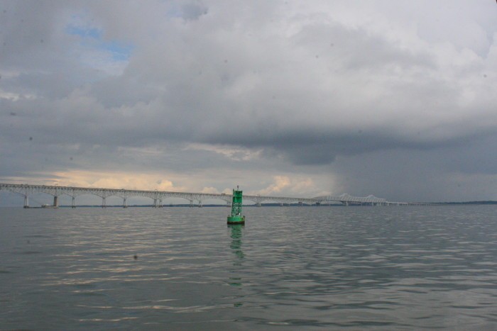
We continue heading to the Bay Bridge and take to the left. I take a picture that shows how calm the waters are now. Shortly after passing under the bridge and heading up towards the Bodkin I see dark storm clouds coming. I get drenched from a sudden rainshower, then get hit with a blast of wind. It is strong enough to raise many whitecaps on the flat water, little white caps that begin to get larger as the waves build. I spend some time in the pilothouse out of the rain.
.
It takes a while to get up to Bodkin Point, then a long left turn following the channel which goes to Baltimore and also takes us past the shoal at Bodkin Point. I feel exhilarated, giddy, even though I am wet and tired. We follow the markers into the inlet and we dock at our old dock. It’s a little more run down that it was 3 years ago. Captain Chris greets me, he’s just home to his trawler from work. We have beer and wine and he gives me some roast chicken and potato salad. He gets the whole story of the trip. I sleep well.
.
The photo is of the Bay Bridge as storm clouds, wind, and rain engulf it.