The First Mate's Journal
Where to next?
Great Lakes to The Bahamas
Who: Wayne & Pat
Port: Jackson
Favorites
05 November 2009 | Deltaville, VA
16 October 2009 | Deltaville, VA
27 May 2009 | Deltaville
26 May 2009 | Deltaville
25 May 2009 | Deltaville
24 May 2009 | Fishing Bay (N37*32.418 W76*20.203) to Deltaville
23 May 2009 | Great Bridge VA (N36*43.285 W76*14.508) to Fishing Bay VA (N37*32.418 W76*20.203)
22 May 2009 | Buck Island, NC (N36*16.034 W75*57.520) to Great BridgeVA (N36*43.285 W76*14.508)
21 May 2009 | The Alligator River Bridge, NC (N35*53.847 W76*02.024) to Buck Island, NC (N36*16.034 W75*57.520)
20 May 2009 | Alligator River Bridge, NC
19 May 2009 | Alligator River Swing Bridge, NC
17 May 2009 | The Pungo River, NC (N35*33.715 W76*28.557) to Alligator Swing Bridge, NC (N35*53.874 W76*02.024)
16 May 2009 | Eastham Creek Anchorage NC (N35*17.680 W76*36.514) to The Pungo River, NC (N35*33.715 W76*28.557)
15 May 2009 | Town Creek Marina, Beaufort NC (N34*43.519 W76*39.898) to Eastham Creek, NC (N35*17.680 W76*36.514)
14 May 2009 | Town Creek Marina, Beaufort, NC
13 May 2009 | Taylor Creek, Beaufort, NC (34*42.860 76*39.831) to Town Creek Marina, Beaufort, NC
12 May 2009 | Mile Hammock Bay (N34*33.163 W77*19.528) SM#244.5 to Taylor Creek, Beaufort, NC (34*42.860 76*39.831)
11 May 2009 | Wrightsville Beach NC (N34*12.441 W77*47.965) SM#283.2 to Mile Hammock Bay (N34*33.163 W77*19.528) SM#244.5
10 May 2009 | Shallottes Inlet, NC (N33*54.913)SM330 to Wrightsville Beach Anchorage (N34*12.447 W77*47.953)
09 May 2009 | Bull Creek, SC (N33 36.667 W79 06.228) to Shallottes Inlet, NC (N33*54.913)
First Night Trip
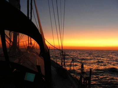
21 August 2008 | Erie, PA to Buffalo, NY to Tonawanda NY 1:30AM
E. Winds 5-10knots; Temp: Low 50s; High Pressure System; � moon very bright though
Oh my gosh! At 1:30 am my phone started playing loud rap music! That was quite an alarm... I probably woke up the sailboat next to us. I definitely need to figure out how to change the volume for the alarm clock - it works quite well LOL!!!
2:15 am with coffee in hand, the anchor came up, and we were navigating in the dark staying between the red and green buoys out of the lagoon. Then into the harbor, find the buoys again, check the charts and out of the harbor, into Lake Erie once more. This is our first night sail and I was on pins and needles all the way out. At 3:50am I plotted our position at 42o11.30 x 80o01.8 and from there we headed 51o to Buffalo. We both stayed up top for a bit, then Wayne took the helm and I went below for a little over an hour before Wayne called me up for sunrise. The horizon started to glow faintly, then turn red for about a half hour before sunrise (6:35am). Sunset today is at 8:35pm which gives us plenty of time to get across the lake and into Buffalo.
It was really difficult to sleep but we both tried catnaps all morning before giving up. I'm sure we look like the living dead. We went under the Peace Bridge that connects Buffalo to Ontario with a vertical clearance of 83 ft.
Comments
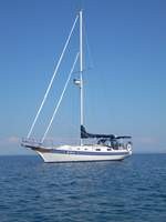
| Vessel Name: | Kolibrie |
| Vessel Make/Model: | Bayfield 36 |
| Hailing Port: | Jackson |
| Crew: | Wayne & Pat |
| About: | Back in Michigan for Hurricane Season 2009... |
| Extra: | Our boat is a Bayfield 36. Not the fastest little thing, but a nice little cruiser that we like to call home. |
| Home Page: | www.kolibrie.us |
Gallery not available
Great Lakes to The Bahamas
Who: Wayne & Pat
Port: Jackson