The First Mate's Journal
Where to next?
Great Lakes to The Bahamas
Who: Wayne & Pat
Port: Jackson
Favorites
05 November 2009 | Deltaville, VA
16 October 2009 | Deltaville, VA
27 May 2009 | Deltaville
26 May 2009 | Deltaville
25 May 2009 | Deltaville
24 May 2009 | Fishing Bay (N37*32.418 W76*20.203) to Deltaville
23 May 2009 | Great Bridge VA (N36*43.285 W76*14.508) to Fishing Bay VA (N37*32.418 W76*20.203)
22 May 2009 | Buck Island, NC (N36*16.034 W75*57.520) to Great BridgeVA (N36*43.285 W76*14.508)
21 May 2009 | The Alligator River Bridge, NC (N35*53.847 W76*02.024) to Buck Island, NC (N36*16.034 W75*57.520)
20 May 2009 | Alligator River Bridge, NC
19 May 2009 | Alligator River Swing Bridge, NC
17 May 2009 | The Pungo River, NC (N35*33.715 W76*28.557) to Alligator Swing Bridge, NC (N35*53.874 W76*02.024)
16 May 2009 | Eastham Creek Anchorage NC (N35*17.680 W76*36.514) to The Pungo River, NC (N35*33.715 W76*28.557)
15 May 2009 | Town Creek Marina, Beaufort NC (N34*43.519 W76*39.898) to Eastham Creek, NC (N35*17.680 W76*36.514)
14 May 2009 | Town Creek Marina, Beaufort, NC
13 May 2009 | Taylor Creek, Beaufort, NC (34*42.860 76*39.831) to Town Creek Marina, Beaufort, NC
12 May 2009 | Mile Hammock Bay (N34*33.163 W77*19.528) SM#244.5 to Taylor Creek, Beaufort, NC (34*42.860 76*39.831)
11 May 2009 | Wrightsville Beach NC (N34*12.441 W77*47.965) SM#283.2 to Mile Hammock Bay (N34*33.163 W77*19.528) SM#244.5
10 May 2009 | Shallottes Inlet, NC (N33*54.913)SM330 to Wrightsville Beach Anchorage (N34*12.447 W77*47.953)
09 May 2009 | Bull Creek, SC (N33 36.667 W79 06.228) to Shallottes Inlet, NC (N33*54.913)
Lockport to Medina
28 August 2008 | Medina, NY
Cloudy, drizzly to light rain today, High: 68-72
Made a Sausage/egg and fruit breakfast after coffee this morning, then, when we went up top I saw a lumber barge was parked down the wall from us. It was the same one we passed on the way here that was cutting branches and trees along the canal. Wow - We both must have been sleeping like logs to miss that guy coming in and tying to the wall last night. Talked to Penelope this morning and let her know that all's well. She called me her wandering little sister; She's always been my Rock of Gibraltar. I got all choked up thinking about her (and Wendell) - our lives and all the paths we've been down as kids and adults. I love you (both)...
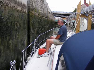
Onward to the Locks - It was exciting - my first lock in the Erie Canal - Lock 35. Armed with mooring lines and boat hooks in hand, we took a portside stance and listened as the doors clanked shut with a creaking groan. The water level started dropping and we dropped the first 25 ft. As the next doors opened there were 2 boats waiting on the same side of the wall as us (one a large tour boat and the other a canal house boat) so we entered the next lock (#34) around them to the starboard side and then they came through into the lock we vacated. Another 25-foot drop and we have now officially transited our 1st two locks on the Erie Canal. The Lock Master told us he'd let the Exchange Street Lift bridge operator know that we were coming, and informed us that the same bridge tender operated the Adams Street Bridge too. So there was only one operator for both bridges - good exercise I guess... It was funny because as we got to the first lift bridge it started opening like magic as we approached. The next one we called to make sure he was there and he told us to come ahead - it'd be open as we got there.
The countryside along the canal is breathtaking in spots. Wildflowers, apple orchards, farms (one farmer was spreading manure from his tractor and some kind of spraying, throwing equip. that jettisoned the cow manure from a trailer attached to the tractor) older homes and newer ones, parks and a few small marinas were scattered about. Sections of the canal were aqueduct and I couldn't get over how in spots, when you looked to the north, the canal was higher than the surrounding landscape. You could look north and see the tops of the houses and waaaaay below, huge fields of corn and orchards. It felt like we were suspended in air looking down on the landscape. I couldn't believe we were - in a boat - in water, but higher than the surrounding landscape. It felt totally bizarre.
Seeing all the beautiful apple trees along the way (wild ones just as lush in their fruit bearing activity as the orchards) made me want an apple so it was apples and oatmeal cookies for lunch LOL. All along the way I kept seeing this incredible sandstone that was strewn along the canal walls, some red, some grey/tan. But it was the same type I have back in my classroom with ripple marks, some quite large. According to the charts it comes from the Medina quarries, which has shipped it's sandstone all over the world. Buckingham palace was one place it was used, that stood out in my mind, along with the base of the Brooklyn Bridge.
We tied up along the south wall of Medina, east of the Medina lift bridge. The bridge tender asked if we'd like the code to use the facilities here and we told him yes, thank you very much. They have free showers (very clean), power, pump out (do it yourself for donations), and water along the south wall. The pump out station looks like an outhouse with a moon cut out LOL - very cute. They also have a small farmers market set up today (Thursday) along the south wall too where the local farmers were selling their fruits and vegetables. We walked through town in the rain and of course I had to ohhhhh and ahhhh and take pictures of all the old architecture, built with the sandstone. They have quite a few churchs here, quite beautiful, and the downtown had made extensive use of the sandstone. Oh, the graffiti on one bridge was quite interesting - very anti-Satan - and I'll leave it at that. We crossed over to the north side - there are tie-ups there for boats that are free too but there's no power or amenities - and followed the canal wall. You could hear it before you could see it - the sound of rushing water. As we rounded a bend you could look down about 100 ft and see forest and a river below the canal, and further around the bend was a waterfall! A river passes under the canal with a waterfall right under the canal!!! It's like the canal truly is suspended over the whole countryside here! Amazing... I can't believe that there were no professional engineers that had a hand in building this canal, aqueduct marvel!!! Further up there's a place where a road goes under the canal. It only has 7 ft clearance, but it's the only road where you can drive under the canal (it crosses over Culvert Rd on an aqueduct). After wandering the town and canal wall we came back to the boat, shook off the rain, and tried to pull in the Lion's game. Reception was bad and we couldn't pull in any channels on the T.V. so we put the T.V. back away after moving it to various places in the boat. In a couple places if you held the end of the antenna you could hear parts of the game over the static, but I wasn't going to stand there acting like an antenna attachment to "listen" to the game... Salmon burgers, salad and oranges for dinner and time to download my pictures...
I'll try and post them in the next few days.
Comments
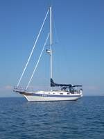
| Vessel Name: | Kolibrie |
| Vessel Make/Model: | Bayfield 36 |
| Hailing Port: | Jackson |
| Crew: | Wayne & Pat |
| About: | Back in Michigan for Hurricane Season 2009... |
| Extra: | Our boat is a Bayfield 36. Not the fastest little thing, but a nice little cruiser that we like to call home. |
| Home Page: | www.kolibrie.us |
Gallery not available
Great Lakes to The Bahamas
Who: Wayne & Pat
Port: Jackson