The First Mate's Journal
Where to next?
Great Lakes to The Bahamas
Who: Wayne & Pat
Port: Jackson
Favorites
05 November 2009 | Deltaville, VA
16 October 2009 | Deltaville, VA
27 May 2009 | Deltaville
26 May 2009 | Deltaville
25 May 2009 | Deltaville
24 May 2009 | Fishing Bay (N37*32.418 W76*20.203) to Deltaville
23 May 2009 | Great Bridge VA (N36*43.285 W76*14.508) to Fishing Bay VA (N37*32.418 W76*20.203)
22 May 2009 | Buck Island, NC (N36*16.034 W75*57.520) to Great BridgeVA (N36*43.285 W76*14.508)
21 May 2009 | The Alligator River Bridge, NC (N35*53.847 W76*02.024) to Buck Island, NC (N36*16.034 W75*57.520)
20 May 2009 | Alligator River Bridge, NC
19 May 2009 | Alligator River Swing Bridge, NC
17 May 2009 | The Pungo River, NC (N35*33.715 W76*28.557) to Alligator Swing Bridge, NC (N35*53.874 W76*02.024)
16 May 2009 | Eastham Creek Anchorage NC (N35*17.680 W76*36.514) to The Pungo River, NC (N35*33.715 W76*28.557)
15 May 2009 | Town Creek Marina, Beaufort NC (N34*43.519 W76*39.898) to Eastham Creek, NC (N35*17.680 W76*36.514)
14 May 2009 | Town Creek Marina, Beaufort, NC
13 May 2009 | Taylor Creek, Beaufort, NC (34*42.860 76*39.831) to Town Creek Marina, Beaufort, NC
12 May 2009 | Mile Hammock Bay (N34*33.163 W77*19.528) SM#244.5 to Taylor Creek, Beaufort, NC (34*42.860 76*39.831)
11 May 2009 | Wrightsville Beach NC (N34*12.441 W77*47.965) SM#283.2 to Mile Hammock Bay (N34*33.163 W77*19.528) SM#244.5
10 May 2009 | Shallottes Inlet, NC (N33*54.913)SM330 to Wrightsville Beach Anchorage (N34*12.447 W77*47.953)
09 May 2009 | Bull Creek, SC (N33 36.667 W79 06.228) to Shallottes Inlet, NC (N33*54.913)
Birds, sandbars, skipjacks
18 October 2008 | La trappe to Cambridge MD
N. Winds 20-25, 2-5 ft waves, high 54, low 37
Woke up to the sound of geese calling each other before sunrise. I wish I could speak goose this morning. I wanted Wayne to hear them lowly calling to each other in the darkness. Big mistake. Remember the rain last night? It collected in the window and as I opened it, Wayne didn't appreciate the cold water in the face. Oops... There's a lot of conversation going on out there that I don't understand as they collect into bigger groups. The conversation in the bed after the wet face I do understand...perfectly...
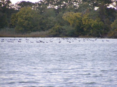
Made some coffee and went up top to look at our surroundings. Since it was about dark when we pulled in last evening, I didn't really see much. The colors are more pronounced here than in Annapolis and there's an amazing amount of birds here. I couldn't begin to name them. They're different than what I'm used to back home. An osprey is sitting atop a tree branch, various petrels are soaring and diving for breakfast, hundreds of little white birds are sitting on the sand spit off Martin Point, and there's a huge flock, no two huge flocks of some birds that are into synchronized flying - darting and flitting around as one entity above me. The geese are collected all over the creek and river in various groups calling to each other. I can hear guns in the distance so I know that there is some kind of hunting season. Wayne says "it's probably water fowl" since there seems to be an abundance of them migrating right now. He reminds me of the first time I was on a sailboat (Hans' boat - a little Westerly) on Lake Erie. We ran aground and stayed the night there in the fog. At daybreak there was the sound of guns going off, even though you couldn't see anything, duck season had begun. Funny how I'd forgotten about that - it seems so long ago, also in October, also cold and damp. Who'd have thought that 30 some odd years later we'd be sitting on our own sailboat, in the cold, listening to water fowl and guns again remembering my first time on a sailboat. Well, at least we're not aground, and in the fog (yet). Not sure where we're heading yet today. Depends on weather. It looks like maybe the Patuxent River, Solomon's Island is within our distance at 35.3 miles.
Hmmmm... well scratch that place on Patuxent River. In coming out of the Creek at 10:00 am, we ran aground in 4.2 ft of water. We were supposed to follow the same path out as we took in (9ft), but veered off to the right a little ran into mud and couldn't get off. Phone has no dots but we tried backing out. No luck. Tried going forward, no luck. Tried hoisting the sail to heel us over, and the sail ended up in the lazy jacks, shrouds, and got a bit twisted due to the wind abate (abaft? Behind) at 20 knots. So basically, no luck. A fishing boat came by and signaled do you want me to call someone? I yelled yes please - Boat US. So he called and wished us "Good Luck". I brought my phone up top and got 1 dot and tried Boat US and got through. I asked if someone called for us and she said Nick called. Thank you Nick, where ever you are. I hope you catch a lot of crabs (the good kind), or fish, or whatever you try to catch. Tow Jamm 2 showed up at around 12:30 and we were freed at 1:00pm. To late to go 30 miles, so we decided to go down to the Little Choptank (I couldn't see returning to the same anchorage - even though it was gorgeous - and having a repeat tomorrow morning). There's free tie up in front of the Dorchester County Building with enough room for 4 boats (ifff they tie up nicely to let a 4th boat get in). We couldn't snug in behind the small sailboat that had taken up a lot of room that he didn't need. In trying to, I ran aground (4 ft) but was able to back off again. We circled around the little area between the drawbridge leading into Cambridge proper, the Dorchester County Building and Snappers Water Front Caf� in 11 ft of water. Hope we're okay here (2:40pm) because Skipper Bob's called this an anchorage (???). Sooo all that's missing now is the fog (from that first time on a sailboat) LOL. Wayne says I jinxed us this morning mentioning running aground. I told him he ran us aground on purpose because I put it in his mind... We passed a pretty little skip jack coming through Little Choptank. What a beautiful little boat! Low shear, large sail and a boom longer than the back of the boat. It was taking people out on the Choptank River.
After dark a riverboat came by us. It was the kind with the big paddle wheel off the back. There were people partying inside and outside - it looked pretty fun.
Comments
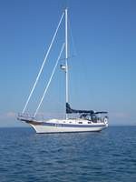
| Vessel Name: | Kolibrie |
| Vessel Make/Model: | Bayfield 36 |
| Hailing Port: | Jackson |
| Crew: | Wayne & Pat |
| About: | Back in Michigan for Hurricane Season 2009... |
| Extra: | Our boat is a Bayfield 36. Not the fastest little thing, but a nice little cruiser that we like to call home. |
| Home Page: | www.kolibrie.us |
Gallery not available
Great Lakes to The Bahamas
Who: Wayne & Pat
Port: Jackson